|
Okuyoshino Pumped Storage Power Station
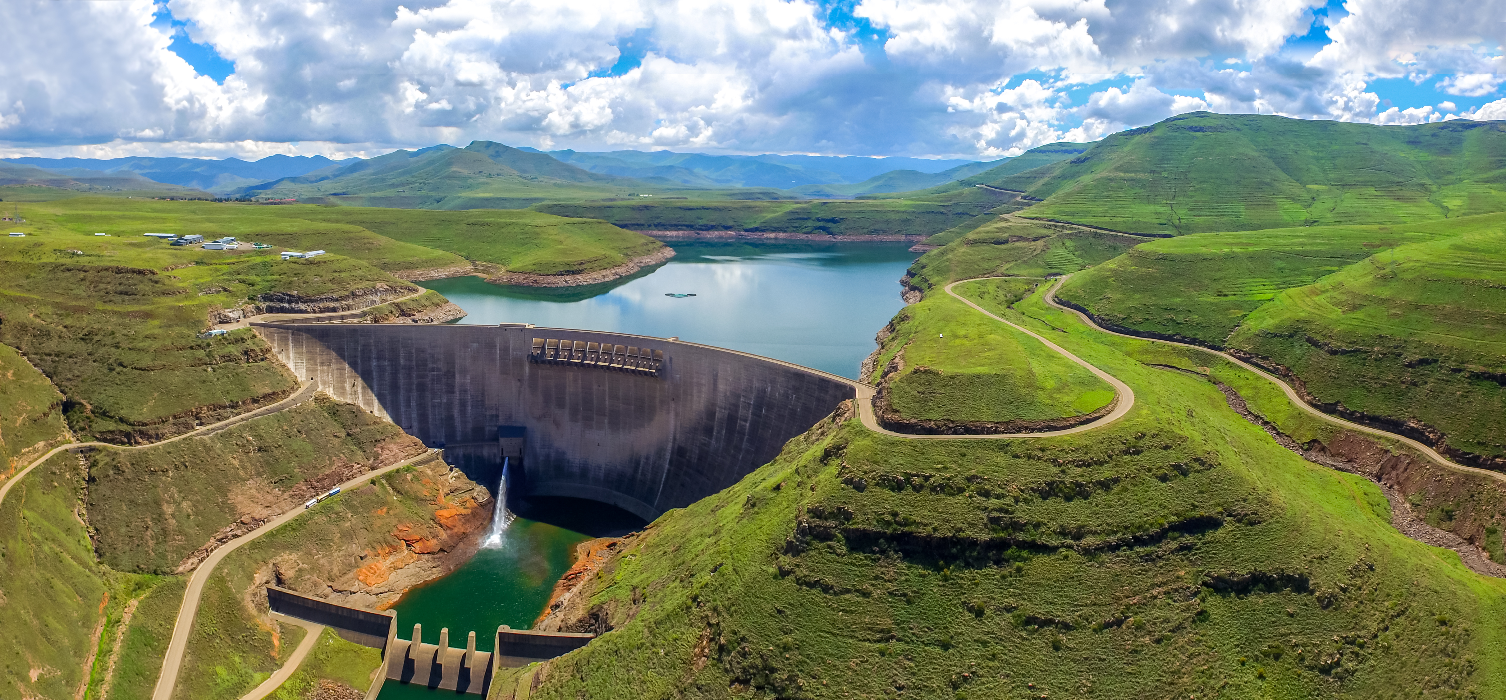
The Okuyoshino Pumped Storage Power Station (奥吉野発電所) is located north of Totsukawa in Nara Prefecture, Japan. Using the pumped-storage hydroelectric method, the power plant has an installed capacity of . To accomplish power generation, the power station shifts water between two reservoirs, the lower Asahi Reservoir and the upper Seto Reservoir. Construction on both the Asahi and Seto Dams began in 1971 and was complete in 1978. The power station was commissioned in 1980. Due to heavy sediment and turbidity in the Seto Reservoir, caused by logging and landslides upstream, a sediment bypass tunnel was constructed between 1992 and 1998. Design and operation Asahi Dam The lower reservoir is created by the Asahi Dam which is a tall and long arch dam on the Asahi River of the Shingu River system. Its catchment area covers an area of and the surface of the reservoir covers . The lower reservoir's storage capacity is of which is active (or usable) for pumping up to the ... [...More Info...] [...Related Items...] OR: [Wikipedia] [Google] [Baidu] |
Totsukawa, Nara
is a village located in Yoshino District, Nara Prefecture, Japan. It is the largest village in Japan in terms of area. As of January 2017, the village has an estimated population of 3,488 and a density of 5.2 persons per km2. The total area is 672.35 km2. History In 1889, a major flood happened in Totsukawa, causing widespread destruction. In result, many citizens moved to Hokkaido and developed a new village there. It was named “ Shintotsukawa”, meaning “New Totsukawa" . Geography Climate Totsukawa has a humid subtropical climate (Köppen climate classification ''Cfa''), which is hot and humid in the summer (above ) and is somewhat cold in the winter with temperatures dropping to around freezing () Demographics Per Japanese census data, the population of Totsukawa in 2020 is 3,061 people. Totsukawa has been conducting censuses since 1920. Landmarks * Tanize Suspension Bridge (谷瀬の吊り橋): a suspension bridge known for the ''Yuredaiko'', an annual drum ... [...More Info...] [...Related Items...] OR: [Wikipedia] [Google] [Baidu] |
Asahi River
The Asahi River is a river in Okayama Prefecture is a Prefectures of Japan, prefecture of Japan located in the Chūgoku region of Honshu. Okayama Prefecture has a population of 1,906,464 (1 February 2018) and has a geographic area of 7,114 Square kilometre, km2 (2,746 sq mi). Okayama Prefectur ..., Japan. References Rivers of Okayama Prefecture Rivers of Japan {{Japan-river-stub ... [...More Info...] [...Related Items...] OR: [Wikipedia] [Google] [Baidu] |
Energy Infrastructure Completed In 1980
In physics, energy (from Ancient Greek: ἐνέργεια, ''enérgeia'', “activity”) is the quantitative property that is transferred to a body or to a physical system, recognizable in the performance of work and in the form of heat and light. Energy is a conserved quantity—the law of conservation of energy states that energy can be converted in form, but not created or destroyed. The unit of measurement for energy in the International System of Units (SI) is the joule (J). Common forms of energy include the kinetic energy of a moving object, the potential energy stored by an object (for instance due to its position in a field), the elastic energy stored in a solid object, chemical energy associated with chemical reactions, the radiant energy carried by electromagnetic radiation, and the internal energy contained within a thermodynamic system. All living organisms constantly take in and release energy. Due to mass–energy equivalence, any object that has mass when ... [...More Info...] [...Related Items...] OR: [Wikipedia] [Google] [Baidu] |
List Of Power Stations In Japan ...
This page is a list of power stations in Japan that are publicly or privately owned. List Former power station * Senju Thermal Power Station See also *Electricity sector in Japan *Energy in Japan *List of largest power stations in the world References {{Economy of Japan Japan Power stations Power stations A power station, also referred to as a power plant and sometimes generating station or generating plant, is an industrial facility for the generation of electric power. Power stations are generally connected to an electrical grid. Many pow ... [...More Info...] [...Related Items...] OR: [Wikipedia] [Google] [Baidu] |
List Of Pumped-storage Hydroelectric Power Stations
The following page lists all pumped-storage hydroelectric power stations that are larger than in installed generating capacity, which are currently operational or under construction. Those power stations that are smaller than , and those that are decommissioned or only at a planning/proposal stage may be found in regional lists, listed at the end of the page. List of plants larger than 1000 MW capacity The table below lists currently operational power stations. Some of these may have additional units under construction, but only current installed capacity is listed. Under construction This table lists future 1,000 MW or larger stations that are under construction; some may be partially operational with a current installed capacity under 1,000 MW. See also * List of energy storage projects * List of hydroelectric power station failures * Lists of hydroelectric power stations * List of largest power stations * United States Department of Energy Global Ener ... [...More Info...] [...Related Items...] OR: [Wikipedia] [Google] [Baidu] |
Weir
A weir or low head dam is a barrier across the width of a river that alters the flow characteristics of water and usually results in a change in the height of the river level. Weirs are also used to control the flow of water for outlets of lakes, ponds, and reservoirs. There are many weir designs, but commonly water flows freely over the top of the weir crest before cascading down to a lower level. Etymology There is no single definition as to what constitutes a weir and one English dictionary simply defines a weir as a small dam, likely originating from Middle English ''were'', Old English ''wer'', derivative of root of ''werian,'' meaning "to defend, dam". Function Commonly, weirs are used to prevent flooding, measure water discharge, and help render rivers more navigable by boat. In some locations, the terms dam and weir are synonymous, but normally there is a clear distinction made between the structures. Usually, a dam is designed specifically to impound water behind ... [...More Info...] [...Related Items...] OR: [Wikipedia] [Google] [Baidu] |
Hydraulic Head
Hydraulic head or piezometric head is a specific measurement of liquid pressure above a vertical datum., 410 pages. See pp. 43–44., 650 pages. See p. 22. It is usually measured as a liquid surface elevation, expressed in units of length, at the entrance (or bottom) of a piezometer. In an aquifer, it can be calculated from the depth to water in a piezometric well (a specialized water well), and given information of the piezometer's elevation and screen depth. Hydraulic head can similarly be measured in a column of water using a standpipe piezometer by measuring the height of the water surface in the tube relative to a common datum. The hydraulic head can be used to determine a ''hydraulic gradient'' between two or more points. "Head" in fluid dynamics In fluid dynamics, ''head'' is a concept that relates the energy in an incompressible fluid to the height of an equivalent static column of that fluid. From Bernoulli's principle, the total energy at a given point in a fluid i ... [...More Info...] [...Related Items...] OR: [Wikipedia] [Google] [Baidu] |
Embankment Dam
An embankment dam is a large artificial dam. It is typically created by the placement and compaction of a complex semi-plastic mound of various compositions of soil or rock. It has a semi-pervious waterproof natural covering for its surface and a dense, impervious core. This makes the dam impervious to surface or seepage erosion. Such a dam is composed of fragmented independent material particles. The friction and interaction of particles binds the particles together into a stable mass rather than by the use of a cementing substance. Types Embankment dams come in two types: the earth-filled dam (also called an earthen dam or terrain dam) made of compacted earth, and the rock-filled dam. A cross-section of an embankment dam shows a shape like a bank, or hill. Most have a central section or core composed of an impermeable material to stop water from seeping through the dam. The core can be of clay, concrete, or asphalt concrete. This type of dam is a good choice for sites wit ... [...More Info...] [...Related Items...] OR: [Wikipedia] [Google] [Baidu] |
Drainage Basin
A drainage basin is an area of land where all flowing surface water converges to a single point, such as a river mouth, or flows into another body of water, such as a lake or ocean. A basin is separated from adjacent basins by a perimeter, the '' drainage divide'', made up of a succession of elevated features, such as ridges and hills. A basin may consist of smaller basins that merge at river confluences, forming a hierarchical pattern. Other terms for a drainage basin are catchment area, catchment basin, drainage area, river basin, water basin, and impluvium. In North America, they are commonly called a watershed, though in other English-speaking places, "watershed" is used only in its original sense, that of a drainage divide. In a closed drainage basin, or endorheic basin, the water converges to a single point inside the basin, known as a sink, which may be a permanent lake, a dry lake, or a point where surface water is lost underground. Drainage basins are similar ... [...More Info...] [...Related Items...] OR: [Wikipedia] [Google] [Baidu] |
Arch Dam
An arch dam is a concrete dam that is curved upstream in plan. The arch dam is designed so that the force of the water against it, known as hydrostatic pressure, presses against the arch, causing the arch to straighten slightly and strengthening the structure as it pushes into its foundation or abutments. An arch dam is most suitable for narrow canyons or gorges with steep walls of stable rock to support the structure and stresses. Since they are thinner than any other dam type, they require much less construction material, making them economical and practical in remote areas. Classification In general, arch dams are classified based on the ratio of the base thickness to the structural height (b/h) as: * Thin, for b/h less than 0.2, * Medium-thick, for b/h between 0.2 and 0.3, and * Thick, for b/h ratio over 0.3. Arch dams classified with respect to their structural height are: * Low dams up to , * Medium high dams between , * High dams over . History The developme ... [...More Info...] [...Related Items...] OR: [Wikipedia] [Google] [Baidu] |
Kansai Electric Power Company
, also known as , is an electric utility with its operational area of Kansai region, Japan (including the Keihanshin megalopolis). The Kansai region is Japan's second-largest industrial area, and in normal times, its most nuclear-reliant. Before the Fukushima nuclear disaster, a band of 11 nuclear reactors – north of the major cities Osaka and Kyoto – supplied almost 50 percent of the region's power. As of January 2012, only one of those reactors was still running. In March 2012, the last reactor was taken off the powergrid. Power plants Kansai Electric Power Company has 164 plants with a total production capacity of 35,760 MW. Nuclear Thermal Hydro Accidents and incidents Mihama accident in 2004 On 9 August 2004, KEPCO reported that five of its employees were killed by a steam burst in the turbines housing building, at the Mihama Nuclear Power Plant in Fukui Prefecture. The burst, according to KEPCO, was due to the neglect of mandated safety checks and the ... [...More Info...] [...Related Items...] OR: [Wikipedia] [Google] [Baidu] |


.jpg)

