|
Oka–Don Lowland
The Oka–Don Lowlands (russian: Окско-Донская равнина) (also: Oka–Don Plain), is a flat plain in European Russia, bounded on the north by the Oka River (and the Meshchera Lowlands), on the south by the Don River, on the west by the Central Russian Upland, and on the east by the Volga Upland. The area is part of the larger East European Plain. The terrain is flat, with altitude averaging 160 meters above sea level, and the rivers meander on broad floodplains. Agricultural use of the plain is high, mostly for grain growing – wheat, barley and rye. The plain provides a flat south–north route for transportation, situated between uplands. Until a line of forts was built across the territory by the Russian government in the 1640s (the Belgorod Line), the plain was a route for Tatar invasion from the south. Topography The plain is about 250 km west–east, and 500 km north–south. The central and southern parts are sometimes called the "Tambov plain", ... [...More Info...] [...Related Items...] OR: [Wikipedia] [Google] [Baidu] |
Russia
Russia (, , ), or the Russian Federation, is a List of transcontinental countries, transcontinental country spanning Eastern Europe and North Asia, Northern Asia. It is the List of countries and dependencies by area, largest country in the world, with its internationally recognised territory covering , and encompassing one-eighth of Earth's inhabitable landmass. Russia extends across Time in Russia, eleven time zones and shares Borders of Russia, land boundaries with fourteen countries, more than List of countries and territories by land borders, any other country but China. It is the List of countries and dependencies by population, world's ninth-most populous country and List of European countries by population, Europe's most populous country, with a population of 146 million people. The country's capital and List of cities and towns in Russia by population, largest city is Moscow, the List of European cities by population within city limits, largest city entirely within E ... [...More Info...] [...Related Items...] OR: [Wikipedia] [Google] [Baidu] |
Ryazan Oblast
Ryazan Oblast ( rus, Рязанская область, r=Ryazanskaya oblast, p=rʲɪˈzanskəjə ˈobləsʲtʲ) is a federal subjects of Russia, federal subject of Russia (an oblast). Its administrative center is the types of inhabited localities in Russia, city of Ryazan, which is the oblast's largest city. Geography Ryazan Oblast borders Vladimir Oblast (N), Nizhny Novgorod Oblast (NE), the Republic of Mordovia (E), Penza Oblast (SE), Tambov Oblast (S), Lipetsk Oblast (SW), Tula Oblast (W), and Moscow Oblast (NW). In terms of physical geography, Ryazan Oblast lies in the central part of the Russian Plain between the Central Russian Upland, Central Russian and Volga Upland, Volga uplands. The terrain is flat, with the highest point of no more than 300 m above sea level. Soils are podzolic and boggy on the left bank of the Oka River, Oka, changing southward to more fertile podzolic and leached black-earths (chernozem, chernozyom). Hydrography Most of the Ryazan Oblast lies wi ... [...More Info...] [...Related Items...] OR: [Wikipedia] [Google] [Baidu] |
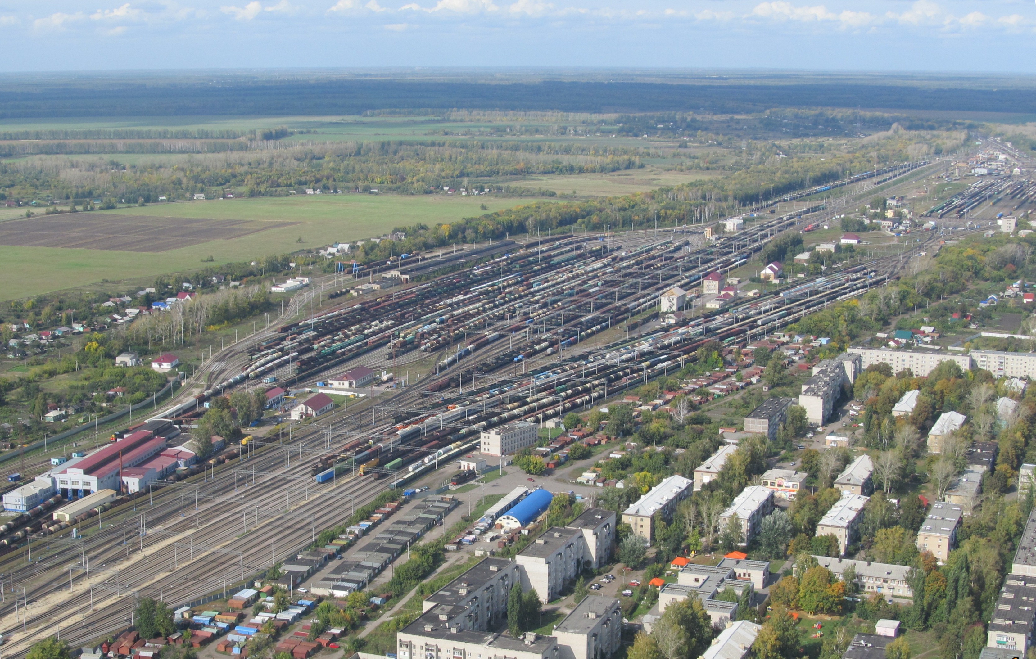
Freight Station North Of Michurinsk
Cargo consists of bulk goods conveyed by water, air, or land. In economics, freight is cargo that is transported at a freight rate for commercial gain. ''Cargo'' was originally a shipload but now covers all types of freight, including transport by rail, van, truck, or intermodal container. The term cargo is also used in case of goods in the cold-chain, because the perishable inventory is always in transit towards a final end-use, even when it is held in cold storage or other similar climate-controlled facility. The term freight is commonly used to describe the movements of flows of goods being transported by any mode of transportation. Multi-modal container units, designed as reusable carriers to facilitate unit load handling of the goods contained, are also referred to as cargo, especially by shipping lines and logistics operators. Similarly, aircraft ULD boxes are also documented as cargo, with an associated packing list of the items contained within. When empty containe ... [...More Info...] [...Related Items...] OR: [Wikipedia] [Google] [Baidu] |
Voronina Nature Reserve
Voronina (Voroninsky) Nature Reserve (russian: Воронинский заповедник) is a strict ecological reserve (a ''zapovednik'') located in the valley of the Vorona River (the right tributary of the Khopyor River), in the forest-steppe zone of southwest Russia. The Voroninsky Reserve protects riverine wetlands in the southeast of the Oka–Don Plain. The reserve is situated in Kirsanovsky and Inzhavinsky districts of Tambov Oblast, about 100 km southeast of the city of Tambov. It was created in 1994, and covers an area of . Topography The Voronina Reserve has a terrain that is relatively flat river valley plain, with some spurs of the Central Uplands. The river valley, of glacial alluvial origin, is 2–6 km wide, and at the most 60–70 meters below the adjacent plateau. The average altitude is about 160 meters above sea level. About 78% of the reserve is wooded, and the remainder is wetlands and open field. The reserve consists of two large protect ... [...More Info...] [...Related Items...] OR: [Wikipedia] [Google] [Baidu] |
Forb
A forb or phorb is an herbaceous flowering plant that is not a graminoid (grass, sedge, or rush). The term is used in biology and in vegetation ecology, especially in relation to grasslands and understory. Typically these are dicots without woody stems. Etymology The word "forb" is derived from Greek ''phorbḗ'' (), meaning "pasture" or "fodder". The Hellenic spelling "phorb" is sometimes used, and in older usage this sometimes includes graminids and other plants currently not regarded as forbs. Guilds Forbs are members of a guilda group of plant species with broadly similar growth form. In certain contexts in ecology, guild membership may often be more important than the taxonomic relationships between organisms. In informal classification In addition to its use in ecology, the term "forb" may be used for subdividing popular guides to wildflowers, distinguishing them from other categories such as grasses, sedges, shrubs, and trees. Some examples of forbs are clovers, s ... [...More Info...] [...Related Items...] OR: [Wikipedia] [Google] [Baidu] |
Medveditsa River (Don Basin)
The Medveditsa (russian: Медве́дица) is a river in Volgograd and Saratov Oblasts in Russia, a left tributary of the Don.Медведица (река в Саратовской и Волгоградской обл.) The name means ''she-bear'', and according to legend alludes to the large population of s in the area in earlier times. It is long, with a |
Khopyor River
The Khopyor (, also transliterated as Khoper) is a river in European Russia, the biggest left tributary of the river Don.Хопёр It is long, with a watershed of .«Река Хопер» Russian State Water Registry The width is . The Khopyor is navigable up to from the mouth. The maximum discharge is ; the aver ... [...More Info...] [...Related Items...] OR: [Wikipedia] [Google] [Baidu] |
Moksha River
Moksha (, ) is a river in central Russia, a right tributary of the Oka. It flows through Penza Oblast, Nizhny Novgorod Oblast, Ryazan Oblast and the Republic of Mordovia, and joins the Oka near Pyatnitsky Yar, near the city of Kasimov. It is in length, and has a drainage basin of .«Река МОКША» Russian State Water Registry In the 1950s, several hydroelectric power stations were built in the middle course of the river, but without navigable locks. In 1955, 2 km below the mouth of the river. Prices on the Moksha River built Rasypukhinsky hydro-power plant with a hydroelectric power station and a wooden shipping lock. Navigation on the river was carried out until the mid-1990s. On the Moksha is the Trinity-Scans monastery, the Nativity-Theotokos Sanaksar Monastery and the Krasnoslobodsky Savior-Transfiguration Monas ... [...More Info...] [...Related Items...] OR: [Wikipedia] [Google] [Baidu] |
Tsna River (Moksha Basin)
The Tsna (in its upper part: ''Mokraya Vershina'') is a river in the Tambov and Ryazan oblasts of Russia, a left tributary of the Moksha (Volga basin). The length of the river is 451 km. The catchment area is 21500 km². The height of the mouth is 86 m above sea level. On the river are the cities of Kotovsk, Tambov, Morshansk, Sasovo. It begins in the Sampursky District under the name of ''Mokraya Vershina''. Tributaries The Tsna has the following tributaries, from mouth to source: *22 km: Aleshnya *31 km: Vyalsa *67 km: Vysha (Noksa) *74 km: Aza *98 km: Shacha *187 km: Kashma *200 km: Piterka *222 km: Kersha *246 km: Chelnovaya *365 km: Lesnoy Tambov *375 km: Lipovitsa *381 km: river without a name, near Vorontsovka *386 km: Karian *406 km: Antiushevka *420 km: Osinovka *425 km: Ponzari Karian - length 48 km, Lipovitsa - 52 km, Lesnoy Tambov - 89 km, Chelnaya 121 ... [...More Info...] [...Related Items...] OR: [Wikipedia] [Google] [Baidu] |
Podzol
In soil science, podzols are the typical soils of coniferous or boreal forests and also the typical soils of eucalypt forests and heathlands in southern Australia. In Western Europe, podzols develop on heathland, which is often a construct of human interference through grazing and burning. In some British moorlands with podzolic soils, cambisols are preserved under Bronze Age barrows (Dimbleby, 1962). Term Podzol means "under-ash" and is derived from the Russian под (pod) + зола́ (zola); the full form is "подзо́листая по́чва" (podzolistaya pochva, "under-ashed soil"). The term was first given in middle of 1875 by Vasily Dokuchaev. It refers to the common experience of Russian peasants of plowing up an apparent under-layer of ash (leached or E horizon) during first plowing of a virgin soil of this type. Characteristics Podzols can occur on almost any parent material but generally derive from either quartz-rich sands and sandstone or sedimentary debri ... [...More Info...] [...Related Items...] OR: [Wikipedia] [Google] [Baidu] |
Voronezh Oblast
Voronezh Oblast (russian: Воронежская область, Voronezhskaya oblast) is a federal subject of Russia (an oblast). Its administrative center is the city of Voronezh. Its population was 2,308,792 as of the 2021 Census. Geography Voronezh Oblast borders internally with Belgorod Oblast, Kursk Oblast, Lipetsk Oblast, Tambov Oblast, Saratov Oblast, Volgograd Oblast and Rostov Oblast and internationally with Ukraine. Voronezh Oblast is located in the central belt of the European part of Russia, in a very advantageous strategic location, transport links to the site going to the industrial regions of Russia. Within the radius (12 hours of driving 80 km/h) 960 kilometers around Voronezh more than 50% of the population Russia, and 40% in Ukraine live. The area of the region - 52.4 thousand km2, which is about one third of the whole area of Central Black Earth Region. The length of the region from north to south - 277.5 km, and from west to east - 352 km. Mu ... [...More Info...] [...Related Items...] OR: [Wikipedia] [Google] [Baidu] |
Penza Oblast
Penza Oblast (russian: Пе́нзенская о́бласть, ''Penzenskaya oblast'') is a federal subject of Russia (an oblast). Its administrative center is the city of Penza. As of the 2010 Census, its population was 1,386,186. Geography The highest point of Penza Oblast is an unnamed hill of the Khvalynsk Mountains reaching above sea level located at the southeastern end, near Neverkino. Main rivers Penza Oblast has over 3000 rivers; the overall length is 15,458 km. The biggest rivers are: * Sura; *Moksha; *Khopyor. * Penza River gave its name to the city of Penza. Fauna There are 316 species of vertebrates within the region, including: *about 10 species of amphibians; *about 200 species of birds; *about 8 species of reptiles; *about 68 species of mammals (fox, rabbit, ferret, badger, squirrel). Seven existing species of mammals were already acclimatized on land: the American mink, muskrat, raccoon dog, wild boar, Siberian roe deer, red deer and Sika d ... [...More Info...] [...Related Items...] OR: [Wikipedia] [Google] [Baidu] |


.jpg)