|
Ogasawara, Tokyo
is a village in Ogasawara Subprefecture, Tokyo Metropolis, Japan, that governs the Bonin Islands, Volcano Islands, and three remote islands ( Nishinoshima, Minamitorishima and Okinotorishima). History In 1940, five municipalities were created in the islands, which had been unincorporated before, two on Chichijima, two on Hahajima, and one on Iwojima. * on Chichijima * on Chichijima * on Hahajima * on Hahajima * on Iwojima (Iōtō), which includes all of the Volcano Islands Both villages of Kita Iwo Jima became part of the newly created Iwojima municipality in 1940: *Ishinomura (east) *Nishimura (west) Following World War II, the islands were administered by the United States. The islands were returned to Japanese control in 1968 and organized as Ogasawara Village. Airport plan In August 2020, the Tokyo Metropolitan Government held a council about a potential airport. It would be operational in 10 years at the earliest. The mayor of Ogasawara Village, Kazuo Morishita sai ... [...More Info...] [...Related Items...] OR: [Wikipedia] [Google] [Baidu] |
List Of Villages In Japan
A is a Local government, local administrative unit in Japan. It is a local public body along with , , and . Geographically, a village's extent is contained within a prefecture. It is larger than an actual settlement, being in actuality a subdivision of a rural , which are subdivided into towns and villages with no overlap and no uncovered area. As a result of merger and dissolution of municipalities of Japan, mergers and elevation to higher statuses, the number of villages in Japan is decreasing. Currently, 13 prefectures no longer have any villages: Tochigi Prefecture, Tochigi (since March 20, 2006), Fukui Prefecture, Fukui (since March 3, 2006), Ishikawa Prefecture, Ishikawa (since March 1, 2005), Shizuoka Prefecture, Shizuoka (since July 1, 2005), Hyōgo Prefecture, Hyōgo (since April 1, 1999), Mie Prefecture, Mie (since November 1, 2005), Shiga Prefecture, Shiga (since January 1, 2005), Hiroshima Prefecture, Hiroshima (since November 5, 2004), Yamaguchi Prefecture, Yamag ... [...More Info...] [...Related Items...] OR: [Wikipedia] [Google] [Baidu] |
Minamitorishima
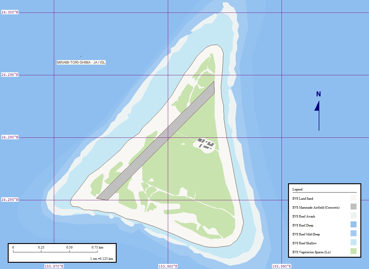
, also known as Marcus Island, is an isolated Japanese coral atoll in the northwestern Pacific Ocean, located some southeast of Tokyo and east of the closest Japanese island, South Iwo Jima of the Ogasawara Islands, and nearly on a straight line between mainland Tokyo and Wake Island, further to the east-southeast. The closest island to Minamitorishima is East Island in the Mariana Islands, which is to the west-southwest. It is the easternmost territory belonging to Japan, and the only Japanese territory on the Pacific Plate, past the Japan Trench. Although small () it is of strategic importance, as it enables Japan to claim a exclusive economic zone in the surrounding waters. It is also the easternmost territory of Tokyo, being administratively part of Ogasawara village. There is no civilian population, except personnel of the Japan Meteorological Agency, JSDF, and Japan Coast Guard serving temporary tours of duty on the island. Access The island is off-limits to civili ... [...More Info...] [...Related Items...] OR: [Wikipedia] [Google] [Baidu] |
Chichi-jima
, formerly known as Peel Island, is the largest island in the Ogasawara Islands, Ogasawara archipelago. Chichijima is about north of Iwo Jima. The island is within the political boundaries of Ogasawara, Tokyo, Ogasawara Village, Ogasawara Subprefecture, Tokyo, Japan. 2,120 people live on its land area of . History The first European discovery of the Ogasawara Islands is said to have taken place in 1549 by the Spain, Spanish explorer Bernardo de la Torre. Archeological excavations show that Micronesian people, Micronesians lived on the island in the past, though no details are yet known. The Tokugawa Shogunate dispatched an expedition in 1675 and made a map of the island. It remained uninhabited until May 1830. Nineteenth century Western ships visited the island on several occasions in the 19th century, including: *The Frederick William Beechey, Beechey Pacific expedition on HMS Blossom (1806), HMS ''Blossom'' in 1827 *Naturalist Heinrich von Kittlitz in 1828 with the Russia ... [...More Info...] [...Related Items...] OR: [Wikipedia] [Google] [Baidu] |
Okino Torishima
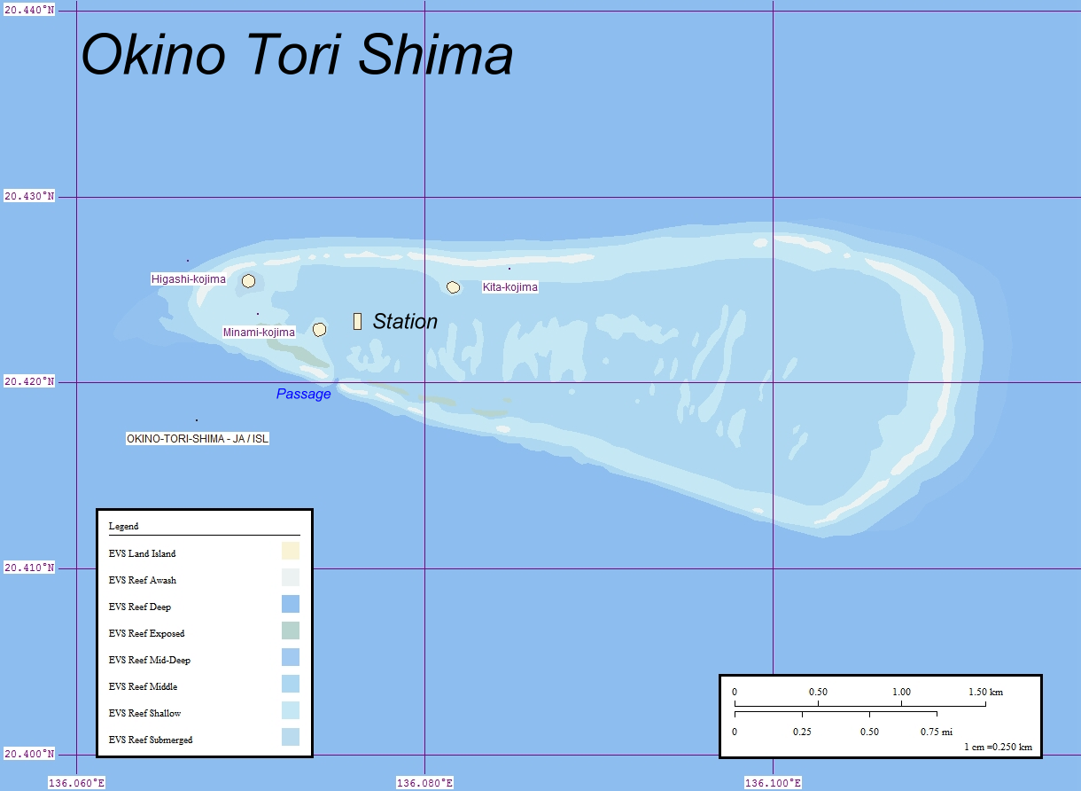
, or Parece Vela, is a coral reef with two rocks enlarged with tetrapod-cement structures. It is administered by Japan with a total shoal area of and land area . Its dry land area is mostly made up by three concrete encasings and there is a stilt platform in the lagoon housing a research station. There is a third completely artificial tetrapod-cement islet. It is located on the Palau–Kyushu Ridge in the Philippine Sea, southeast of Okidaitōjima and west-southwest of South Iwo Jima in the Bonin Islands or south of Tokyo, Japan. The atoll is the southernmost part of Japan and the only Japanese territory south of the Tropic of Cancer. Japan argues that the atoll is significant enough for it to claim a exclusive economic zone (EEZ) around it, but China, South Korea, and Taiwan dispute the Japanese EEZ, saying that the atoll does not meet the definition of an island under the United Nations Convention on the Law of the Sea. History The atoll may have been sighted first b ... [...More Info...] [...Related Items...] OR: [Wikipedia] [Google] [Baidu] |
Minami-Tori-shima
, also known as Marcus Island, is an isolated Japanese coral atoll in the northwestern Pacific Ocean, located some southeast of Tokyo and east of the closest Japanese island, South Iwo Jima of the Ogasawara Islands, and nearly on a straight line between mainland Tokyo and Wake Island, further to the east-southeast. The closest island to Minamitorishima is East Island in the Mariana Islands, which is to the west-southwest. It is the easternmost territory belonging to Japan, and the only Japanese territory on the Pacific Plate, past the Japan Trench. Although small () it is of strategic importance, as it enables Japan to claim a exclusive economic zone in the surrounding waters. It is also the easternmost territory of Tokyo, being administratively part of Ogasawara village. There is no civilian population, except personnel of the Japan Meteorological Agency, JSDF, and Japan Coast Guard serving temporary tours of duty on the island. Access The island is off-limits to ci ... [...More Info...] [...Related Items...] OR: [Wikipedia] [Google] [Baidu] |
South Iwo Jima
, native_name_link = , image_caption = Minami-Iōtō , image_size = , pushpin_map = Japan complete , pushpin_label = South Iwo Jima , pushpin_label_position = , pushpin_map_alt = , pushpin_relief = , pushpin_map_caption = , map_custom = , nickname = , location = Pacific Ocean , coordinates = , archipelago = Volcano Islands , total_islands = , major_islands = , area_km2 = 3.54 , length_km = , width_km = , coastline_km = 7.5 , highest_mount = , elevation_m = 916 , country = Japan , country_admin_divisions_title = Prefecture , country_admin_divisions = Tokyo , country_admin_divisions_title_1 = Subprefecture , country_admin_divisions_1 = Ogasawara Subprefecture , country_admin_divisions_title_2 = Village , country_admin_divisions_2 = Ogasawara , population = 0 , populati ... [...More Info...] [...Related Items...] OR: [Wikipedia] [Google] [Baidu] |
Yuriko Koike
is a Japanese politician who currently serves as the Governor of Tokyo since 2016. She graduated from the American University in Cairo in 1976 and was a member of the House of Representatives of Japan from 1993 until 2016, when she resigned to run for Governor of Tokyo. She also previously served as Minister of the Environment in the Junichiro Koizumi cabinet from 2003 to 2006 and briefly as Minister of Defense in the first cabinet of Shinzō Abe in 2007.Koike decides to leave post, cites responsibility over information leak , JapanNewsReview.com; accessed 18 June 2015. Koike was |
Tokyo Metropolitan Government
The is the government of the Tokyo Metropolis. One of the 56 prefectures of Japan, the government consists of a popularly elected governor and assembly. The headquarters building is located in the ward of Shinjuku. The metropolitan government administers the special wards, cities, towns and villages that constitute part of the Tokyo Metropolis. With a population closing in on 14 million living within its boundaries, and many more commuting from neighbouring prefectures, the metropolitan government wields significant political power within Japan. Structure of Tokyo Metropolis Under Japanese law, Tokyo is designated as a ''to'' ( 都), translated as ''metropolis''. Within Tokyo Metropolis lie dozens of smaller entities, including twenty-three special wards (特別 区 -ku) which until 1943 made up Tokyo City but which now have individual local governments, each with a leader and a council. In addition to these 23 local governments, Tokyo also encompasses 26 cities ( 市 -shi), ... [...More Info...] [...Related Items...] OR: [Wikipedia] [Google] [Baidu] |
North Iwo Jima
, native_name_link = , image_caption = Kita-Iwō-jima , image_size = , pushpin_map = Japan complete , pushpin_label = North Iwo Jima , pushpin_label_position = , pushpin_map_alt = , pushpin_relief = , pushpin_map_caption = , map_custom = , nickname = , location = Pacific Ocean , coordinates = , archipelago = Volcano Islands , total_islands = , major_islands = , area_km2 = 5.57 , length_km = , width_km = , coastline_km = 8.0 , highest_mount = Sakagi-ga-mine , elevation_m = 792 , country = Japan , country_admin_divisions_title = Prefecture , country_admin_divisions = Tokyo , country_admin_divisions_title_1 = Subprefecture , country_admin_divisions_1 = Ogasawara Subprefecture , country_admin_divisions_title_2 = Village , country_admin_divisions_2 = Ogasawara , population ... [...More Info...] [...Related Items...] OR: [Wikipedia] [Google] [Baidu] |
Iōjima, Tokyo
was a village in the Japanese prefecture of Tokyo. Its administrative area covered the whole island of Iwo Jima (officially ''Iōtō'' since 2007), one of the Volcano Islands. It existed from 1923 when the Ogasawara islands were organized into modern municipalities to 1952 when mainland Tokyo returned to Japanese sovereignty and Iwo Jima was put under US military administration. When the island was returned to Japan in 1968 it became part of the village of Ogasawara, Tokyo. In 1943, the village had a population of 1,018 in 192 households. For a period the population was fewer than 1,200. Administratively the villages and towns on Tokyo's islands were never subordinate to counties, but through subprefectures more directly tied to the prefectural administration (Home Ministry An interior ministry (sometimes called a ministry of internal affairs or ministry of home affairs) is a government department that is responsible for internal affairs. Lists of current ministries of interna ... [...More Info...] [...Related Items...] OR: [Wikipedia] [Google] [Baidu] |
Hahajima
, native_name_link = , image_caption = Map of the Hahajima Rettō (Imōtojima is mislabeled as Tori-shima) , image_size = , pushpin_map = Japan complete , pushpin_label = Hahajima , pushpin_label_position = , pushpin_map_alt = , pushpin_relief = , pushpin_map_caption = , map_custom = , nickname = , location = Pacific Ocean , coordinates = , archipelago = Ogasawara Islands , total_islands = , major_islands = , area_km2 = 19.88 , length_km = , width_km = , coastline_km = , highest_mount = Chibusayama , elevation_m = 462 , country = Japan , country_admin_divisions_title = Prefecture , country_admin_divisions = Tokyo , country_admin_divisions_title_1 = Subprefecture , country_admin_divisions_1 = Ogasawara Subprefecture , country_admin_divisions_title_2 = Village , country_admin_divisions_ ... [...More Info...] [...Related Items...] OR: [Wikipedia] [Google] [Baidu] |


