|
Oceanic Gyres
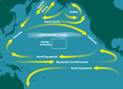
In oceanography, a gyre () is any large system of circulating ocean currents, particularly those involved with large wind movements. Gyres are caused by the Coriolis effect; planetary vorticity, horizontal friction and vertical friction determine the circulatory patterns from the ''wind stress curl'' (torque). ''Gyre'' can refer to any type of vortex in an atmosphere or a sea, even one that is human-created, but it is most commonly used in terrestrial oceanography to refer to the major ocean systems. Major gyres The following are the five most notable ocean gyres:The five most notable gyres PowerPoint Presentation * * |
Oceanography
Oceanography (), also known as oceanology and ocean science, is the scientific study of the oceans. It is an Earth science, which covers a wide range of topics, including ecosystem dynamics; ocean currents, waves, and geophysical fluid dynamics; plate tectonics and the geology of the sea floor; and fluxes of various chemical substances and physical properties within the ocean and across its boundaries. These diverse topics reflect multiple disciplines that oceanographers utilize to glean further knowledge of the world ocean, including astronomy, biology, chemistry, climatology, geography, geology, hydrology, meteorology and physics. Paleoceanography studies the history of the oceans in the geologic past. An oceanographer is a person who studies many matters concerned with oceans, including marine geology, physics, chemistry and biology. History Early history Humans first acquired knowledge of the waves and currents of the seas and oceans in pre-historic times. Observations ... [...More Info...] [...Related Items...] OR: [Wikipedia] [Google] [Baidu] |
South Pacific Gyre
__NOTOC__ The Southern Pacific Gyre is part of the Earth's system of rotating ocean currents, bounded by the Equator to the north, Australia to the west, the Antarctic Circumpolar Current to the south, and South America to the east. The center of the South Pacific Gyre is the oceanic pole of inaccessibility, the site on Earth farthest from any continents and productive ocean regions and is regarded as Earth's largest oceanic desert. The gyre, as with Earth's other four gyres, contains an area with elevated concentrations of pelagic plastics, chemical sludge, and other debris known as the South Pacific garbage patch. Sediment flux and accumulation Earth's trade winds and Coriolis force cause the ocean currents in South Pacific Ocean to circulate counterclockwise. The currents act to isolate the center of the gyre from nutrient upwelling and few nutrients are transported there by the wind (eolian processes) because there is relatively little land in the Southern Hemisphere to su ... [...More Info...] [...Related Items...] OR: [Wikipedia] [Google] [Baidu] |
Kuroshio Current
The , also known as the Black or or the is a north-flowing, warm ocean current on the west side of the North Pacific Ocean basin. It was named for the deep blue appearance of its waters. Similar to the Gulf Stream in the North Atlantic, the Kuroshio is a powerful western boundary current that transports warm equatorial water poleward and forms the western limb of the North Pacific Gyre, North Pacific Subtropical Gyre. Off the East Coast of Japan, it merges with the Oyashio Current to form the North Pacific Current. The Kuroshio Current has significant effects on both physical and biological processes of the North Pacific Ocean, including nutrient and sediment transport, major pacific storm tracks and regional climate, and Pacific mode water formation.Terazaki, Makoto (1989) "Recent Large-Scale Changes in the Biomass of the Kuroshio Current Ecosystem" in Kenneth Sherman and Lewis M. Alexander (eds.), Biomass Yields and Geography of Large Marine Ecosystems (Boulder: Westview) AAA ... [...More Info...] [...Related Items...] OR: [Wikipedia] [Google] [Baidu] |
Gulf Stream
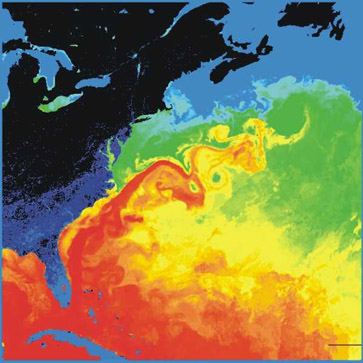
The Gulf Stream, together with its northern extension the North Atlantic Current, North Atlantic Drift, is a warm and swift Atlantic Ocean, Atlantic ocean current that originates in the Gulf of Mexico and flows through the Straits of Florida and up the eastern coastline of the United States then veers east near 36 latitude (North Carolina) and moves toward Northwest Europe as the North Atlantic Current. The process of Boundary current, western intensification causes the Gulf Stream to be a northwards accelerating current off the east coast of North America. At about , it splits in two, with the northern stream, the North Atlantic Drift, crossing to Northern Europe and the southern stream, the Canary Current, recirculating off West Africa. The Gulf Stream influences the climate of the coastal areas of the east coast of the United States from Florida to southeast Virginia (near 36 north latitude), and to a greater degree the climate of Northwest Europe. There is consensus that t ... [...More Info...] [...Related Items...] OR: [Wikipedia] [Google] [Baidu] |
Boundary Current
Boundary currents are ocean currents with dynamics determined by the presence of a coastline, and fall into two distinct categories: western boundary currents and eastern boundary currents. Eastern boundary currents Eastern boundary currents are relatively shallow, broad and slow-flowing. They are found on the eastern side of oceanic basins (adjacent to the western coasts of continents). Subtropical eastern boundary currents flow equatorward, transporting cold water from higher latitudes to lower latitudes; examples include the Benguela Current, the Canary Current, the Humboldt (Peru) Current, and the California Current. Coastal upwelling often brings nutrient-rich water into eastern boundary current regions, making them productive areas of the ocean. Western boundary currents Western boundary currents may themselves be divided into sub-tropical or low-latitude western boundary currents. Sub-tropical western boundary currents are warm, deep, narrow, and fast-flowing currents t ... [...More Info...] [...Related Items...] OR: [Wikipedia] [Google] [Baidu] |
Downwelling
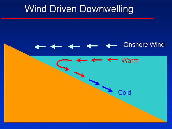
Downwelling is the process of accumulation and sinking of higher density material beneath lower density material, such as cold or saline water beneath warmer or fresher water or cold air beneath warm air. It is the ''sinking'' limb of a convection cell. Upwelling is the opposite process, and together, these two forces are responsible in the oceans for the thermohaline circulation. The sinking of the cold lithosphere at subduction zones is another example of downwelling in plate tectonics. Oceanic downwelling Downwelling occurs in anti-cyclonic regions of the ocean where warm rings spin clockwise, causing surface convergence. When these surface waters converge, the surface water is pushed downwards. Downwelling can also occur as a result of the wind driving the sea towards the coastline. Downwelling regions have low productivity because the nutrients in the water column are used but are not continuously replenished by cold, nutrient-rich water from below the surface. Oxygenati ... [...More Info...] [...Related Items...] OR: [Wikipedia] [Google] [Baidu] |
Ocean Circulation Model
Ocean general circulation models (OGCMs) are a particular kind of general circulation model to describe physical and thermodynamical processes in oceans. The oceanic general circulation is defined as the horizontal space scale and time scale larger than mesoscale (of order 100 km and 6 months). They depict oceans using a three-dimensional grid that include active thermodynamics and hence are most directly applicable to climate studies. They are the most advanced tools currently available for simulating the response of the global ocean system to increasing greenhouse gas concentrations. A hierarchy of OGCMs have been developed that include varying degrees of spatial coverage, resolution, geographical realism, process detail, etc. History The first generation of OGCMs assumed “rigid lid” to eliminate high-speed external gravity waves. According to CFL criteria without those fast waves, we can use a bigger time step, which is not so computationally expensive. But it also filt ... [...More Info...] [...Related Items...] OR: [Wikipedia] [Google] [Baidu] |
Geostrophic Flow
A geostrophic current is an oceanic current in which the pressure gradient force is balanced by the Coriolis effect. The direction of geostrophic flow is parallel to the isobars, with the high pressure to the right of the flow in the Northern Hemisphere, and the high pressure to the left in the Southern Hemisphere. This concept is familiar from weather maps, whose isobars show the direction of geostrophic winds. Geostrophic flow may be either barotropic or baroclinic. A geostrophic current may also be thought of as a rotating shallow water wave with a frequency of zero. The principle of ''geostrophy'' or ''geostrophic balance'' is useful to oceanographers because it allows them to infer ocean currents from measurements of the sea surface height (by combined satellite altimetry and gravimetry) or from vertical profiles of seawater density taken by ships or autonomous buoys. The major currents of the world's oceans, such as the Gulf Stream, the Kuroshio Current, the Agulhas Cu ... [...More Info...] [...Related Items...] OR: [Wikipedia] [Google] [Baidu] |
Northern Hemisphere
The Northern Hemisphere is the half of Earth that is north of the Equator. For other planets in the Solar System, north is defined as being in the same celestial hemisphere relative to the invariable plane of the solar system as Earth's North Pole. Owing to Earth's axial tilt of 23.439281°, winter in the Northern Hemisphere lasts from the December solstice (typically December 21 UTC) to the March equinox (typically March 20 UTC), while summer lasts from the June solstice through to the September equinox (typically on 23 September UTC). The dates vary each year due to the difference between the calendar year and the astronomical year. Within the Northern Hemisphere, oceanic currents can change the weather patterns that affect many factors within the north coast. Such events include El Niño–Southern Oscillation. Trade winds blow from east to west just above the equator. The winds pull surface water with them, creating currents, which flow westward due to the Coriolis e ... [...More Info...] [...Related Items...] OR: [Wikipedia] [Google] [Baidu] |
Ekman Transport
Ekman transport is part of Ekman motion theory, first investigated in 1902 by Vagn Walfrid Ekman. Winds are the main source of energy for ocean circulation, and Ekman Transport is a component of wind-driven ocean current. Ekman transport occurs when ocean surface waters are influenced by the friction force acting on them via the wind. As the wind blows it casts a friction force on the ocean surface that drags the upper 10-100m of the water column with it. However, due to the influence of the Coriolis effect, the ocean water moves at a 90° angle from the direction of the surface wind. The direction of transport is dependent on the hemisphere: in the northern hemisphere, transport occurs at 90° clockwise from wind direction, while in the southern hemisphere it occurs at 90° anticlockwise.Colling, pp 42-44 This phenomenon was first noted by Fridtjof Nansen, who recorded that ice transport appeared to occur at an angle to the wind direction during his Arctic expedition during the ... [...More Info...] [...Related Items...] OR: [Wikipedia] [Google] [Baidu] |
Coriolis Force
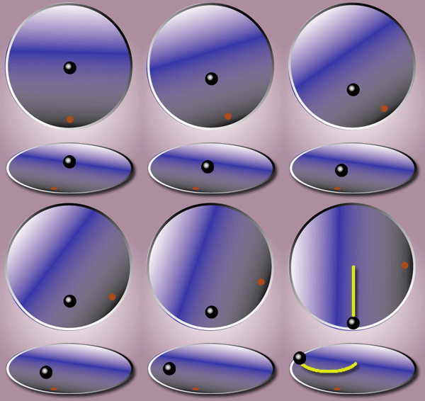
In physics, the Coriolis force is an inertial or fictitious force that acts on objects in motion within a frame of reference that rotates with respect to an inertial frame. In a reference frame with clockwise rotation, the force acts to the left of the motion of the object. In one with anticlockwise (or counterclockwise) rotation, the force acts to the right. Deflection of an object due to the Coriolis force is called the Coriolis effect. Though recognized previously by others, the mathematical expression for the Coriolis force appeared in an 1835 paper by French scientist Gaspard-Gustave de Coriolis, in connection with the theory of water wheels. Early in the 20th century, the term ''Coriolis force'' began to be used in connection with meteorology. Newton's laws of motion describe the motion of an object in an inertial (non-accelerating) frame of reference. When Newton's laws are transformed to a rotating frame of reference, the Coriolis and centrifugal accelerations appe ... [...More Info...] [...Related Items...] OR: [Wikipedia] [Google] [Baidu] |


