|
Ocean Drilling Program
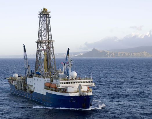
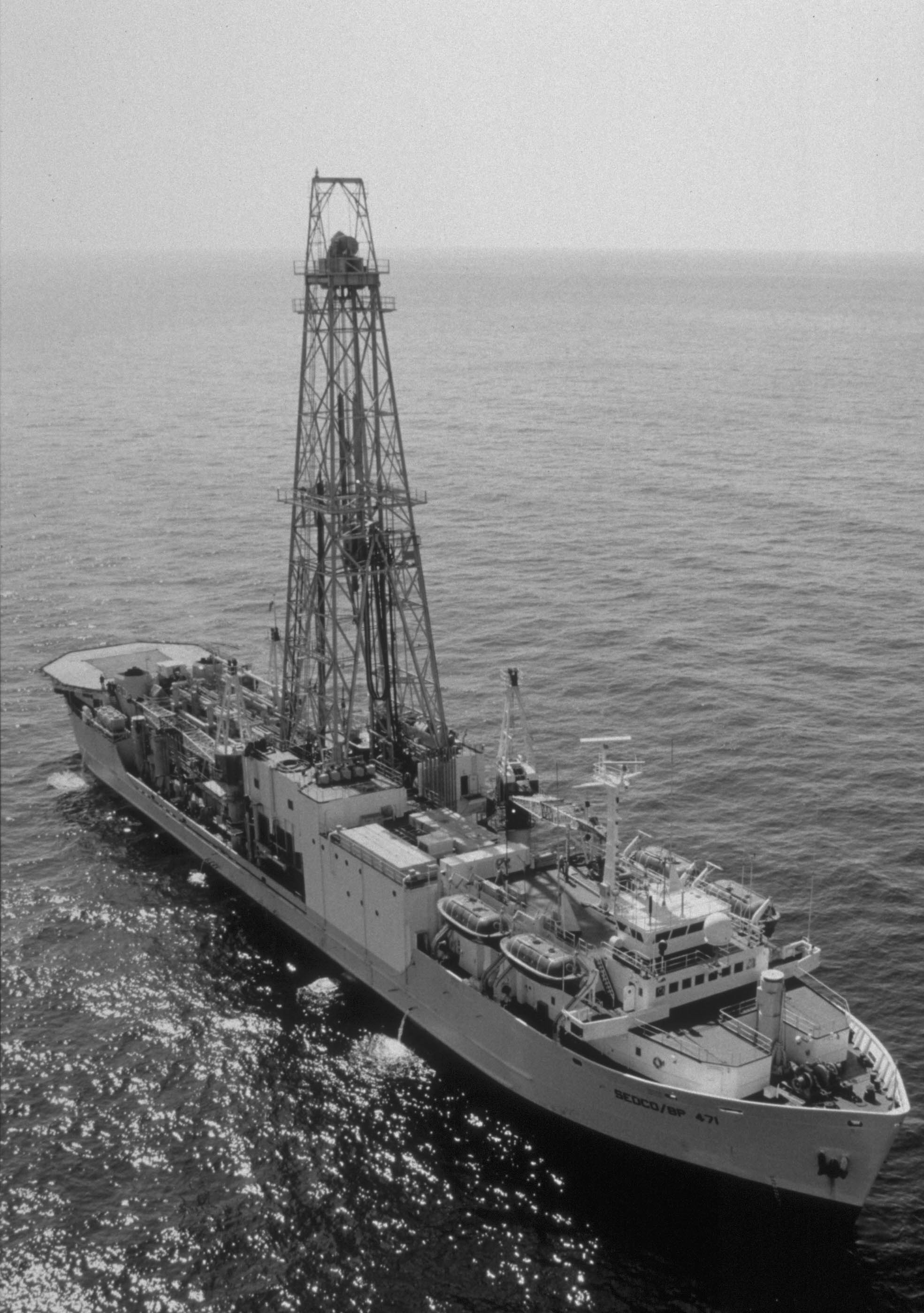
The Ocean Drilling Program (ODP) was a multinational effort to explore and study the composition and structure of the Earth's oceanic basins. ODP, which began in 1985, was the successor to the Deep Sea Drilling Project initiated in 1968 by the United States. ODP was an international effort with contributions of Australia, Germany, France, Japan, the United Kingdom and the ESF Consortium for Ocean Drilling (ECOD) including 12 further countries. The program used the drillship ''JOIDES Resolution'' on 110 expeditions (legs) to collect about 2,000 deep sea cores from major geological features located in the ocean basins of the world. Drilling discoveries led to further questions and hypotheses, as well as to new disciplines in earth sciences such as the field of paleoceanography. In 2004 ODP transformed into the Integrated Ocean Drilling Program (IODP). See also * Project Mohole * Deep Sea Drilling Program * Integrated Ocean Drilling Program * Allison Guyot Allison Guyot (fo ... [...More Info...] [...Related Items...] OR: [Wikipedia] [Google] [Baidu] |
Oceanic Basin
In hydrology, an oceanic basin (or ocean basin) is anywhere on Earth that is covered by seawater. Geologically, ocean basins are large geologic basins that are below sea level. Most commonly the ocean is divided into basins following the continents distribution: the North and South Atlantic (together approximately 75 million km2/ 29 million mi2), North and South Pacific (together approximately 155 million km2/ 59 million mi2), Indian Ocean (68 million km2/ 26 million mi2) and Arctic Ocean (14 million km2/ 5.4 million mi2). Also recognized is the Southern Ocean (20 million km2/ 7 million mi2). All ocean basins collectively cover 71% of the Earth's surface, and together they contain almost 97% of all water on the planet. They have an average depth of almost 4 km (about 2.5 miles). Definitions of boundaries Boundaries based on continents ''"Limits of Oceans and Seas"'',International Hydrographic Organization (IHO), (1953): Limits of Oceans and Seas, Internat ... [...More Info...] [...Related Items...] OR: [Wikipedia] [Google] [Baidu] |
Deep Sea Drilling Project
The Deep Sea Drilling Project (DSDP) was an ocean drilling project operated from 1968 to 1983. The program was a success, as evidenced by the data and publications that have resulted from it. The data are now hosted by Texas A&M University, although the program was coordinated by the Scripps Institution of Oceanography at the University of California, San Diego. DSDP provided crucial data to support the seafloor spreading hypothesis and helped to prove the theory of plate tectonics. DSDP was the first of three international scientific ocean drilling programs that have operated over more than 40 years. It was followed by the Ocean Drilling Program (ODP) in 1985, the Integrated Ocean Drilling Program in 2004 and the present International Ocean Discovery Program in 2013. History The initial contract between the National Science Foundation (NSF) and the Regents of the University of California was signed on June 24, 1966. This contract initiated the first phase of the DSDP, which wa ... [...More Info...] [...Related Items...] OR: [Wikipedia] [Google] [Baidu] |
JOIDES Resolution
295px, Drillship ''JOIDES Resolution'' in 1988 The riserless research vessel ''JOIDES Resolution'' (Joint Oceanographic Institutions for Deep Earth Sampling), often referred to as the JR, is one of the scientific drilling ships used by the International Ocean Discovery Program (IODP), an international, multi-drilling platform research program. The JR was previously the main research ship used during the Ocean Drilling Program (ODP) and was used along with the Japanese drilling vessel ''Chikyu'' and other mission-specific drilling platforms throughout the Integrated Ocean Drilling Program. She is the successor of ''Glomar Challenger''. The ship was first launched in 1978 as ''Sedco/BP 471'', an oil exploration vessel. It was converted for scientific use 6 years later in 1984 and began working as the main research ship for ODP in January 1985. The JR was modernized during 2007–2008 and returned to active service in February 2009 following an extensive renovation of her laboratory f ... [...More Info...] [...Related Items...] OR: [Wikipedia] [Google] [Baidu] |
Paleoceanography
Paleoceanography is the study of the history of the oceans in the geology, geologic past with regard to circulation, chemistry, biology, geology and patterns of sedimentation and biological productivity. Paleoceanographic studies using environment models and different proxies enable the scientific community to assess the role of the oceanic processes in the global climate by the re-construction of past climate at various intervals. Paleoceanographic research is also intimately tied to paleoclimatology. Source and methods of information Paleoceanography makes use of so-called proxy (climate), proxy methods as a way to infer information about the past state and evolution of the world's oceans. Several geochemical proxy tools include long-chain organic molecules (e.g. alkenones), stable and radioactive isotopes, and trace metals. Additionally, sediment cores can also be useful; the field of paleoceanography is closely related to sedimentology and paleontology. Sea-surface tem ... [...More Info...] [...Related Items...] OR: [Wikipedia] [Google] [Baidu] |
Integrated Ocean Drilling Program
The Integrated Ocean Drilling Program (IODP) was an international marine research program. The program used heavy drilling equipment mounted aboard ships to monitor and sample sub-seafloor environments. With this research, the IODP documented environmental change, Earth processes and effects, the biosphere, solid earth cycles, and geodynamics. The program began a new 10-year phase with the International Ocean Discovery Program, from the end of 2013. Navigating the route to discovery Scientific ocean drilling represented the longest running and most successful international collaboration among the Earth sciences. Scientific ocean drilling began in 1961 with the first sample of oceanic crust recovered aboard the ''CUSS 1'', a modified U.S. Navy barge. American author John Steinbeck, also an amateur oceanographer, documented Project Mohole for LIFE Magazine. Legacy programs The Deep Sea Drilling Project (DSDP), established in June 1966, operated the ''Glomar Challenger'' i ... [...More Info...] [...Related Items...] OR: [Wikipedia] [Google] [Baidu] |
Project Mohole
Project Mohole was an attempt in the early 1960s to drill through the Earth's crust to obtain samples of the Mohorovičić discontinuity, or Moho, the boundary between the Earth's crust and mantle. The project was intended to provide an earth science complement to the high-profile Space Race. While such a project was not feasible on land, drilling in the open ocean was more feasible, because the mantle lies much closer to the sea floor. Led by a group of scientists called the American Miscellaneous Society with funding from the National Science Foundation, the project suffered from political and scientific opposition, mismanagement, and cost overruns. The U.S. House of Representatives defunded it in 1966.Mohole, LOCO, CORE, and JOIDES: A brief chronology Betty Shor, The Scripps Institution ... [...More Info...] [...Related Items...] OR: [Wikipedia] [Google] [Baidu] |
Deep Sea Drilling Program
The Deep Sea Drilling Project (DSDP) was an ocean drilling project operated from 1968 to 1983. The program was a success, as evidenced by the data and publications that have resulted from it. The data are now hosted by Texas A&M University, although the program was coordinated by the Scripps Institution of Oceanography at the University of California, San Diego. DSDP provided crucial data to support the seafloor spreading hypothesis and helped to prove the theory of plate tectonics. DSDP was the first of three international scientific ocean drilling programs that have operated over more than 40 years. It was followed by the Ocean Drilling Program (ODP) in 1985, the Integrated Ocean Drilling Program in 2004 and the present International Ocean Discovery Program in 2013. History The initial contract between the National Science Foundation (NSF) and the Regents of the University of California was signed on June 24, 1966. This contract initiated the first phase of the DSDP, which wa ... [...More Info...] [...Related Items...] OR: [Wikipedia] [Google] [Baidu] |
Allison Guyot
Allison Guyot (formerly known as Navoceano Guyot) is a tablemount (guyot) in the underwater Mid-Pacific Mountains of the Pacific Ocean. It is a trapezoidal flat mountain rising 1,500 metres above the seafloor to a depth of less than 1,500 m, with a summit platform 35 by 70 kilometres wide. The Mid-Pacific Mountains lie west of Hawaii and northeast of the Marshall Islands, but at the time of their formation were located in the Southern Hemisphere. The tablemount was probably formed by a hotspot in the present-day Southern Pacific before plate tectonics moved it to its current location. Several hotspots, including the Easter, Marquesas and Society hotspots, may have been involved in the formation of the Mid-Pacific Mountains. Volcanic activity is dated to have occurred circa 111–85 million years ago and formed a volcanic island. Subsequently, carbonate deposition commenced as Allison Guyot subsided and eventually buried the island, forming an atoll-like structure and a carb ... [...More Info...] [...Related Items...] OR: [Wikipedia] [Google] [Baidu] |
Marine Geology
Marine geology or geological oceanography is the study of the history and structure of the ocean floor. It involves geophysical, geochemical, sedimentological and paleontological investigations of the ocean floor and coastal zone. Marine geology has strong ties to geophysics and to physical oceanography. Marine geological studies were of extreme importance in providing the critical evidence for sea floor spreading and plate tectonics in the years following World War II. The deep ocean floor is the last essentially unexplored frontier and detailed mapping in support of both military (submarine) objectives and economic (petroleum and metal mining) objectives drives the research. Overview The Ring of Fire around the Pacific Ocean with its attendant intense volcanism and seismic activity poses a major threat for disastrous earthquakes, tsunamis and volcanic eruptions. Any ''early warning'' systems for these disastrous events will require a more detailed understanding of marine ge ... [...More Info...] [...Related Items...] OR: [Wikipedia] [Google] [Baidu] |


