|
Obthorpe
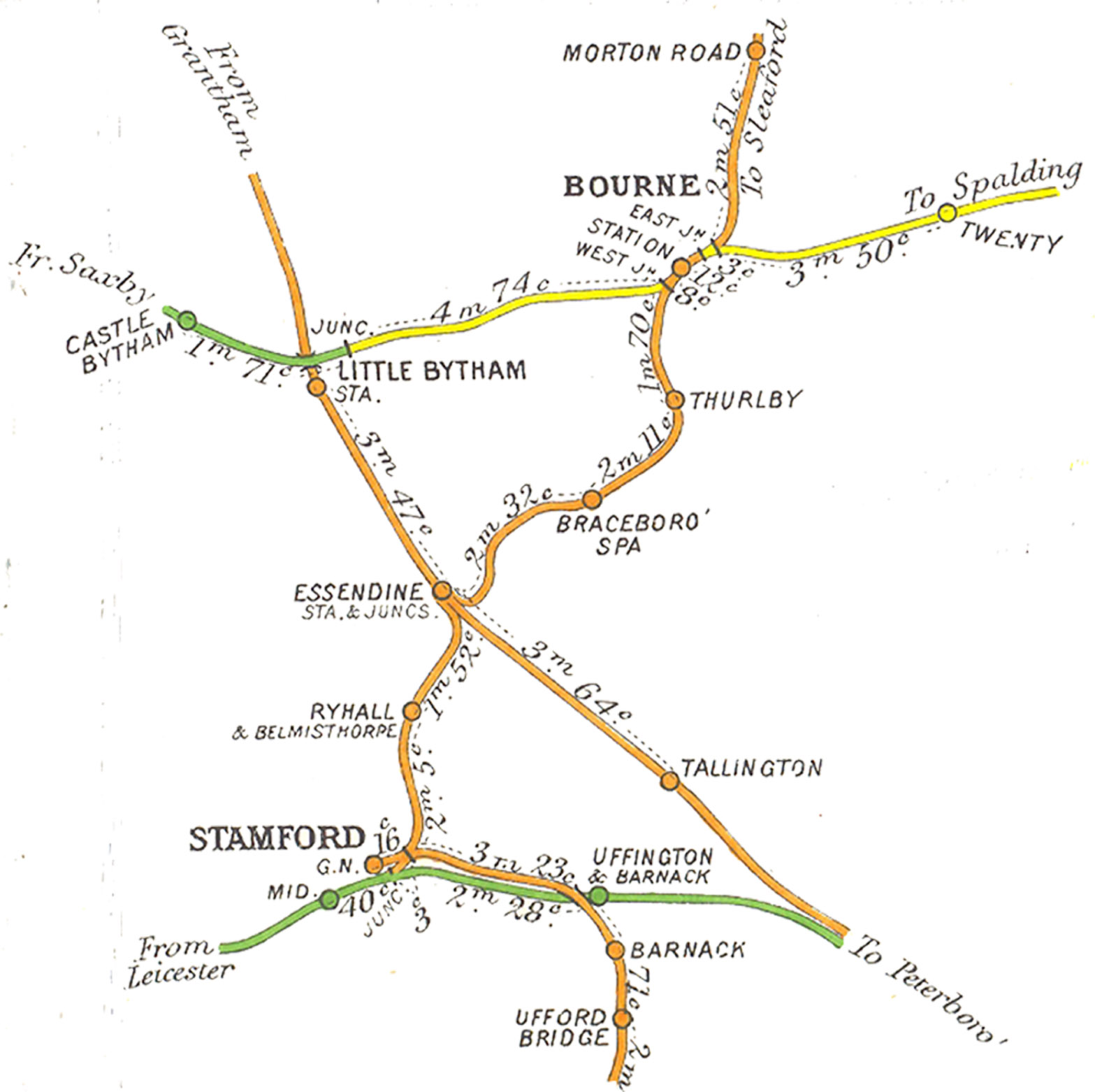
Obthorpe is a hamlet in the civil parish of Thurlby, in the South Kesteven district of Lincolnshire, England. It lies south from Bourne, north-east from Stamford and less than west from the A15. Thurlby is the nearest village, to the north. The house known as Obthorpe Lodge lies about 1 mile due east from the hamlet; both are on the Macmillan Way footpath. Obthorpe is mentioned in the ''Domesday'' account as "Opetorp". The manor comprised 19 households and 17 freemen, and had a meadow and woodland, both of . Lordship in 1066 was held by Ulf Fenman, transferred to Gilbert of Ghent in 1086, who was also Tenant-in-chief. Folio: 355r, ''Great Domesday Book''; |
A15 Road (England)
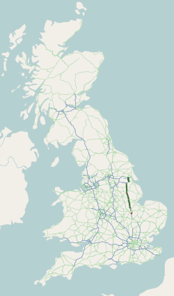
The A15 is a major road in England. It runs north from Peterborough via Market Deeping, Bourne, Sleaford and Lincoln along a variety of ancient, Roman, and Turnpike alignments before it is interrupted at its junction with the M180 near Scawby. The road restarts east, and then continues north past Barton-upon-Humber, crossing the Humber on the Humber Bridge before terminating at Hessle near Kingston upon Hull. Driving conditions According to the AA, the route is long, and should take 2 hours. Norman Cross to Bourne takes 33 minutes, Bourne to Lincoln takes 46 minutes, and Lincoln to the Humber Bridge takes 54 minutes. A section of the A15 (between Scampton and the M180) provides the longest stretch of straight road in the UK. Route Peterborough The A15 is Peterborough's main connecting road from the south to the A1(M), joining near Stilton, at Norman Cross. It begins as ''London Road'' at junction 16 of the A1(M) with the B1043 (former A1) in Cambridgeshire and the di ... [...More Info...] [...Related Items...] OR: [Wikipedia] [Google] [Baidu] |
Thurlby By Bourne
Thurlby is a village and civil parish in the South Kesteven district of Lincolnshire, England. It is situated just west of the A15 road, south from the town of Bourne, and on the edge of the Lincolnshire Fens. It is sometimes referred to as ''Thurlby by Bourne'' to distinguish it from other villages in Lincolnshire with the same name. Thurlby and the hamlet of Northorpe to its north are conjoined. The parish had a population of 2,136 at the 2001 census and 2,153 at the 2011 census. History The Roman Car Dyke passes through the parish to the east of the road. The A15 road itself broadly follows the route of the Roman Road King street. The church of St Firmin dates back to before the Norman Conquest, reportedly to 925 AD. It has features of Saxo-Norman and Perpendicular style. Thurlby is mentioned in the 1086 '' Domesday'' survey as "Tvrolvebi", "Tvrodldbi", "Torulfbi" and "Turoluebi". A Methodist chapel, Trinity Methodist Church, was established in 1912. Thurlby ... [...More Info...] [...Related Items...] OR: [Wikipedia] [Google] [Baidu] |
Domesday
Domesday Book () – the Middle English spelling of "Doomsday Book" – is a manuscript record of the "Great Survey" of much of England and parts of Wales completed in 1086 by order of King William I, known as William the Conqueror. The manuscript was originally known by the Latin name ''Liber de Wintonia'', meaning "Book of Winchester", where it was originally kept in the royal treasury. The ''Anglo-Saxon Chronicle'' states that in 1085 the king sent his agents to survey every shire in England, to list his holdings and dues owed to him. Written in Medieval Latin, it was highly abbreviated and included some vernacular native terms without Latin equivalents. The survey's main purpose was to record the annual value of every piece of landed property to its lord, and the resources in land, manpower, and livestock from which the value derived. The name "Domesday Book" came into use in the 12th century. Richard FitzNeal wrote in the ''Dialogus de Scaccario'' ( 1179) that the book w ... [...More Info...] [...Related Items...] OR: [Wikipedia] [Google] [Baidu] |
The National Archives (United Kingdom)
, type = Non-ministerial department , seal = , nativename = , logo = Logo_of_The_National_Archives_of_the_United_Kingdom.svg , logo_width = 150px , logo_caption = , formed = , preceding1 = , dissolved = , superseding = , jurisdiction = England and Wales, HM Government , headquarters = Kew, Richmond, Greater London TW9 4DU , region_code = GB , coordinates = , employees = 679 , budget = £43.9 million (2009–2010) , minister1_name = Michelle Donelan , minister1_pfo = Secretary of State for Digital, Culture, Media and Sport , minister2_name = TBC , minister2_pfo = Parliamentary Under Secretary of State , chief1_name = Jeff James , chief1_position = Chief Executive and Keeper of the Public Records , chief2_name = , chief2_position = , chief3_name = , chief3_position = , chief4_name = , chief4_position = , chief5_name = , chief5_position = , agency_type = , chief6_name = , chief6_position = , chief7_name = , chief7_position = ... [...More Info...] [...Related Items...] OR: [Wikipedia] [Google] [Baidu] |
Tenant-in-chief
In medieval and early modern Europe, the term ''tenant-in-chief'' (or ''vassal-in-chief'') denoted a person who held his lands under various forms of feudal land tenure directly from the king or territorial prince to whom he did homage, as opposed to holding them from another nobleman or senior member of the clergy.Bloch ''Feudal Society Volume 2'' p. 333Coredon ''Dictionary of Medieval Terms & Phrases'' p. 272 The tenure was one which denoted great honour, but also carried heavy responsibilities. The tenants-in-chief were originally responsible for providing knights and soldiers for the king's feudal army.Bracton, who indiscriminately called tenants-in-chief "barons" stated: "sunt et alii potentes sub rege qui barones dicuntur, hoc est robur belli" ("there are other magnates under the king, who are called barons, that is the hardwood of war"), quoted in Sanders, I.J., ''Feudal Military Service in England'', Oxford, 1956, p.3; "Bracton's definition of the ''baro''" (plur ''baro ... [...More Info...] [...Related Items...] OR: [Wikipedia] [Google] [Baidu] |
Gilbert De Gant, Earl Of Lincoln
Gilbert de Gant, 1st Earl of Lincoln ( 1126 – 1156) was an English nobleman who fought for King Stephen during The Anarchy. He was the son of Walter de Gant (third son of the Domesday magnate Gilbert de Gant, Gant being a contemporary name for Ghent) and Maud of Brittany, a daughter of Stephen, Count of Tréguier. Gilbert was thus a nephew of Alan, 1st Earl of Richmond, one of King Stephen's commanders. Another uncle, Robert de Gant, was Lord Chancellor for King Stephen. His father Walter de Gant is thought to have accompanied David, Earl of Huntingdon (later King David I) when he came north to the Lowlands in the early 1100s. Walter de Gant became known as Walter de Lindsey, a baron in Scotland under King David. He is described in 19th-century clan records using modernized spellings as "Walter de Ghent Now Walter de Lindsay". While still fairly young, Gilbert fought on the side of King Stephen at the Battle of Lincoln in 1141, where he was captured along with the king. ... [...More Info...] [...Related Items...] OR: [Wikipedia] [Google] [Baidu] |
Lord Of The Manor
Lord of the Manor is a title that, in Anglo-Saxon England, referred to the landholder of a rural estate. The lord enjoyed manorial rights (the rights to establish and occupy a residence, known as the manor house and demesne) as well as seignory, the right to grant or draw benefit from the estate. The title continues in modern England and Wales as a legally recognised form of property that can be held independently of its historical rights. It may belong entirely to one person or be a moiety shared with other people. A title similar to such a lordship is known in French as ''Sieur'' or , in German, (Kaleagasi) in Turkish, in Norwegian and Swedish, in Welsh, in Dutch, and or in Italian. Types Historically a lord of the manor could either be a tenant-in-chief if he held a capital manor directly from the Crown, or a mesne lord if he was the vassal of another lord. The origins of the lordship of manors arose in the Anglo-Saxon system of manorialism. Following the N ... [...More Info...] [...Related Items...] OR: [Wikipedia] [Google] [Baidu] |
Serfdom
Serfdom was the status of many peasants under feudalism, specifically relating to manorialism, and similar systems. It was a condition of debt bondage and indentured servitude with similarities to and differences from slavery, which developed during the Late Antiquity and Early Middle Ages in Europe and lasted in some countries until the mid-19th century. Unlike slaves, serfs could not be bought, sold, or traded individually though they could, depending on the area, be sold together with land. The kholops in Russia, by contrast, could be traded like regular slaves, could be abused with no rights over their own bodies, could not leave the land they were bound to, and could marry only with their lord's permission. Serfs who occupied a plot of land were required to work for the lord of the manor who owned that land. In return, they were entitled to protection, justice, and the right to cultivate certain fields within the manor to maintain their own subsistence. Serfs were ofte ... [...More Info...] [...Related Items...] OR: [Wikipedia] [Google] [Baidu] |
Manorialism
Manorialism, also known as the manor system or manorial system, was the method of land ownership (or "tenure") in parts of Europe, notably France and later England, during the Middle Ages. Its defining features included a large, sometimes fortified manor house in which the lord of the manor and his dependents lived and administered a rural estate, and a population of labourers who worked the surrounding land to support themselves and the lord. These labourers fulfilled their obligations with labour time or in-kind produce at first, and later by cash payment as commercial activity increased. Manorialism is sometimes included as part of the feudal system. Manorialism originated in the Roman villa system of the Late Roman Empire, and was widely practiced in medieval western Europe and parts of central Europe. An essential element of feudal society, manorialism was slowly replaced by the advent of a money-based market economy and new forms of agrarian contract. In examining the o ... [...More Info...] [...Related Items...] OR: [Wikipedia] [Google] [Baidu] |
Macmillan Way
The Macmillan Way is a long-distance footpath in England that links Boston, Lincolnshire to Abbotsbury in Dorset. The route's distance is . It is promoted to raise money for the charity Macmillan Cancer Relief. The fully waymarked route follows existing footpaths, bridleways and byways, and small stretches of minor roads when these are unavoidable. It runs across open fen country for its first and for the rest of its journey it then follows the course of the oolitic limestone belt. The Macmillan Way starts from Boston and then runs across the Fens to their western edge at Kate's Bridge near Bourne before joining the limestone belt. From Boston it heads to Stamford and then along the shore of Rutland Water to Oakham. It then leads south and west via Warmington to Stow-on-the-Wold, then through the Cotswolds via Cirencester and Tetbury to Bradford-on-Avon. Then through Somerset and into Dorset via Castle Cary and Sherborne to Abbotsbury on the coast. The route links with ... [...More Info...] [...Related Items...] OR: [Wikipedia] [Google] [Baidu] |
South Kesteven
South Kesteven is a Non-metropolitan district, local government district in Lincolnshire, England, forming part of the traditional Kesteven division of the county. It covers Bourne, Lincolnshire, Bourne, Grantham, Market Deeping and Stamford, Lincolnshire, Stamford. The 2011 census reports 133,788 people at 1.4 per hectare in 57,344 households. The district borders the counties of Cambridgeshire, Leicestershire, Northamptonshire, Nottinghamshire and Rutland. It is also bounded by the Lincolnshire districts of North Kesteven and South Holland, Lincolnshire, South Holland. History The district was formed on 1 April 1974, under the Local Government Act 1972, from the municipal boroughs of Grantham and Stamford, along with Bourne Urban District, South Kesteven Rural District, and West Kesteven Rural District. Previously the district was run by Kesteven County Council, based in Sleaford. Geography South Kesteven borders North Kesteven to the north, as far east as Horbling, where the ... [...More Info...] [...Related Items...] OR: [Wikipedia] [Google] [Baidu] |
Stamford, Lincolnshire
Stamford is a town and civil parish in the South Kesteven District of Lincolnshire, England. The population at the 2011 census was 19,701 and estimated at 20,645 in 2019. The town has 17th- and 18th-century stone buildings, older timber-framed buildings and five medieval parish churches. It is a frequent film location. In 2013 it was rated a top place to live in a survey by ''The Sunday Times''. Its name has been passed on to Stamford, Connecticut, founded in 1641. History Roman and Medieval Stamford The Romans built Ermine Street across what is now Burghley Park and forded the River Welland to the west of Stamford, eventually reaching Lincoln. They also built a town to the north at Great Casterton on the River Gwash. In 61 CE Boudica followed the Roman legion Legio IX Hispana across the river. The Anglo-Saxons later chose Stamford as the main town, being on a larger river than the Gwash. The place-name Stamford is first attested in the Anglo-Saxon Chronicle, where it appears ... [...More Info...] [...Related Items...] OR: [Wikipedia] [Google] [Baidu] |


