|
Nossob River
The Nossob (also Nosob or Nossop) River (''ǂnuse ǃab'', Khoikhoi for black river) is a dry river bed in eastern Namibia and the Kalahari region of South Africa and Botswana. It covers a distance of 740 km and last flooded in 1989. The river also lends its name to Nossob camp in the Kgalagadi Transfrontier Park. Course The Nossob has its origin in two main tributaries, the Swart-Nossob and Wit-Nossob, meaning black and white respectively. Both tributaries have their origins in the eastern slopes of the Otjihavera mountain range, east of Windhoek. Their sources are at 1,800 m and over 2,000 m above sea level respectively. The two river beds have their confluence some 80 km south of Gobabis, which is situated on the bank of the Swart-Nossob. From this confluence the river course passes the settlements of Leonardville and Aranos to arrive at Union's End, South Africa. From Union's End the river bed, forming the Botswana border, meanders through the Kgalagadi ... [...More Info...] [...Related Items...] OR: [Wikipedia] [Google] [Baidu] |
Auob River
The Auob River is a tributary of the Nossob River in the Northern Cape province of South Africa. Headwaters * in Namibia Namibia (, ), officially the Republic of Namibia, is a country in Southern Africa. Its western border is the Atlantic Ocean. It shares land borders with Zambia and Angola to the north, Botswana to the east and South Africa to the south and ea ... Mouth * , Nossob River Route The river flows about southeastward through Namibia and Northern Cape. Rivers of Namibia Rivers of the Northern Cape {{namibia-river-stub ... [...More Info...] [...Related Items...] OR: [Wikipedia] [Google] [Baidu] |
Sea Level
Mean sea level (MSL, often shortened to sea level) is an average surface level of one or more among Earth's coastal bodies of water from which heights such as elevation may be measured. The global MSL is a type of vertical datuma standardised geodetic datumthat is used, for example, as a chart datum in cartography and marine navigation, or, in aviation, as the standard sea level at which atmospheric pressure is measured to calibrate altitude and, consequently, aircraft flight levels. A common and relatively straightforward mean sea-level standard is instead the midpoint between a mean low and mean high tide at a particular location. Sea levels can be affected by many factors and are known to have varied greatly over geological time scales. Current sea level rise is mainly caused by human-induced climate change. When temperatures rise, Glacier, mountain glaciers and the Ice sheet, polar ice caps melt, increasing the amount of water in water bodies. Because most of human settlem ... [...More Info...] [...Related Items...] OR: [Wikipedia] [Google] [Baidu] |
Rivers Of Namibia
This is a list of streams and rivers in Namibia, arranged geographically by drainage basin. Flowing into the Atlantic Ocean * Hoanib River ** Aap River ** Ganamub River ** Mudorib River ** Ombonde River *** Honib River *** Otjovasandu River ** Otjitaimo River ** Tsuchub River * Hoarusib River * Huab River ** Aba Huab River ** Klein Omaruru River ** Klip River ** Ongwati River *** Kakatswa River ** Sout River * Khumib River * Koigab River ** Gui-Tsawisib River ** Springbok River * Kuiseb River ** Chausib River ** Gaub River *** Ubib River ** Goagos River ** Gomab River ** Koam River ** Nausgomab River ** Ojab River * Kunene River * Messum River * Omaruru River ** Goab River ** Leeu River ** Okandjou River ** Otjimakuru River ** Spitzkop River * Orange River ** Fish River ** Konkiep River ** Löwen River ** ''Molopo River (South Africa, Botswana)'' *** Nossob River **** Auob River ***** Oanob River ***** Olifants River ***** Skaap River *** ... [...More Info...] [...Related Items...] OR: [Wikipedia] [Google] [Baidu] |
Oanob Dam
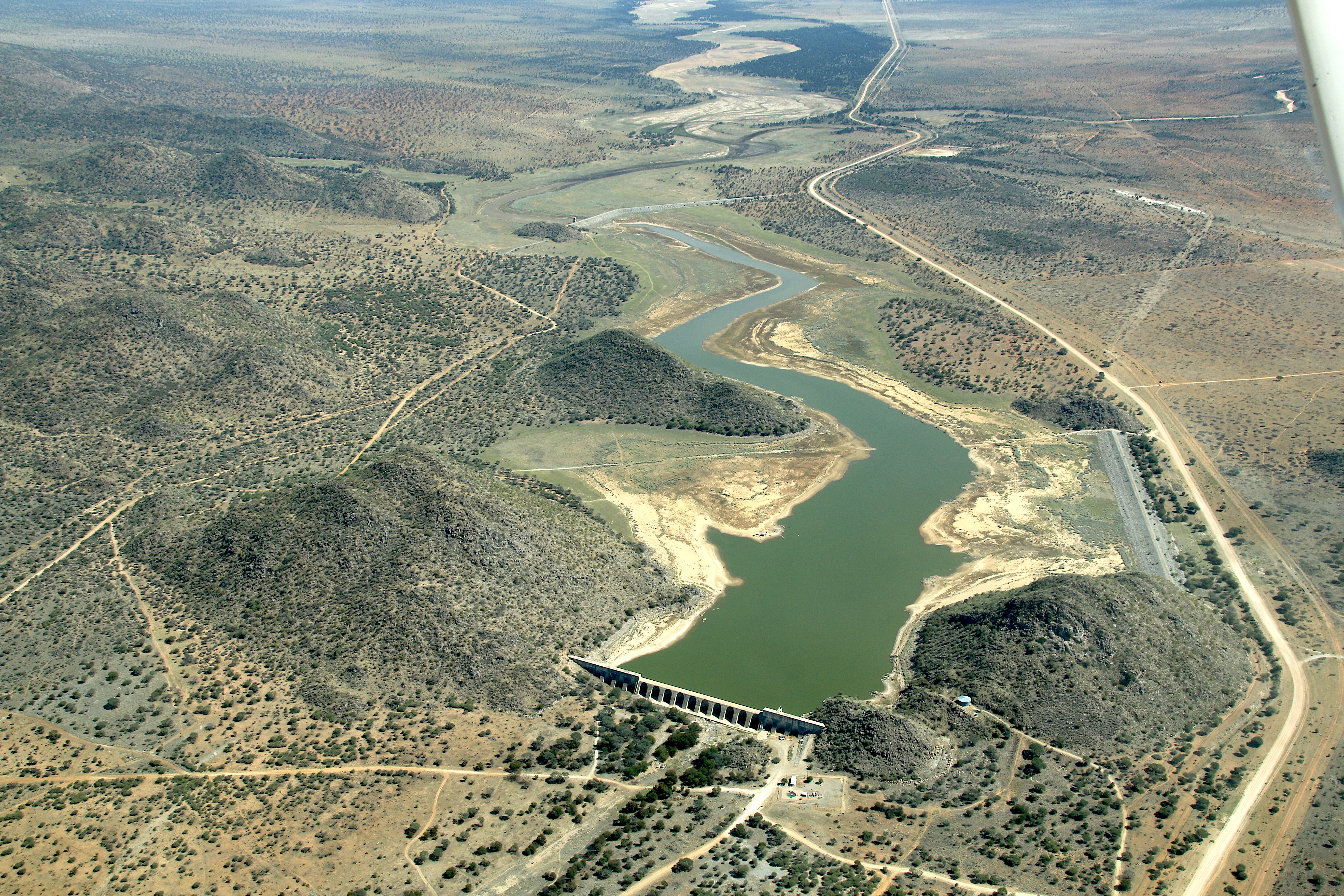
Oanob Dam is a dam outside Rehoboth, Hardap Region, Namibia Namibia (, ), officially the Republic of Namibia, is a country in Southern Africa. Its western border is the Atlantic Ocean. It shares land borders with Zambia and Angola to the north, Botswana to the east and South Africa to the south and ea .... Located outside Rehoboth, it dams the Oanob River and provides the town with a majority of its water. It has a capacity of and was completed in 1990, the year of Namibia's independence. at NamWater.com References Dams in Namibia Rehoboth, Namibia[...More Info...] [...Related Items...] OR: [Wikipedia] [Google] [Baidu] |
Omitara
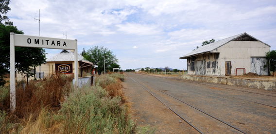
Omitara is a settlement in the Steinhausen electoral constituency in the Omaheke Region of Namibia. Together with the adjacent village of Otjivero — the two places are often referred to as one — it had a population of approximately 1,200 as of October 2008. Otjivero and Omitara Railway Station are two contiguous TransNamib railway stops en route from Windhoek to Gobabis. Economy and Infrastructure Basic Income Grant project In 2008 and 2009, Omitara and Otjivero were the site of a basic income grant test project. Every person under the retirement age of 60 was given 100 Namibian dollars (Namibian pensioners get an independent allowance of 550N$ per month). The follow-up study, published in October 2008, reported that poverty-related crime, malnutrition rates among children and school drop outs had decreased since the inception of the project. The coalition advocating for a BIG in Namibia was led by labour and church organisations, hoping for a nationwide implementation of th ... [...More Info...] [...Related Items...] OR: [Wikipedia] [Google] [Baidu] |
Otjivero Dam
Omitara is a settlement in the Steinhausen electoral constituency in the Omaheke Region of Namibia. Together with the adjacent village of Otjivero — the two places are often referred to as one — it had a population of approximately 1,200 as of October 2008. Otjivero and Omitara Railway Station are two contiguous TransNamib railway stops en route from Windhoek to Gobabis. Economy and Infrastructure Basic Income Grant project In 2008 and 2009, Omitara and Otjivero were the site of a basic income grant test project. Every person under the retirement age of 60 was given 100 Namibian dollars (Namibian pensioners get an independent allowance of 550N$ per month). The follow-up study, published in October 2008, reported that poverty-related crime, malnutrition rates among children and school drop outs had decreased since the inception of the project. The coalition advocating for a BIG in Namibia was led by labour and church organisations, hoping for a nationwide implementation of th ... [...More Info...] [...Related Items...] OR: [Wikipedia] [Google] [Baidu] |
Augrabies Falls
The Augrabies Falls is a waterfall on the Orange River, the largest river in South Africa. Since 1966 the waterfall, set in a desolate and rugged milieu, is enclosed by the Augrabies Falls National Park. The falls are around in height. Some sources cite an approximate height of 480 feet; this is actually the height from the base of the canyon to the top of the walls, not that of the falls themselves. Exploration The original Khoikhoi residents named the waterfall "Ankoerebis" — "place of great noise" — from which the Trek Boers, who settled here later on, derived the name, "Augrabies". The last leader of area's native residents was Klaas Pofadder who lived on an island upstream of the falls, now known as Klaas Island. The first westerner to see the falls was the renegade Swedish mercenary Hendrik Jakob Wikar. He arrived at the falls in October 1778, after years long wanderings in the wilderness. When another traveler, George Thompson, was led to the falls by his Griqua peop ... [...More Info...] [...Related Items...] OR: [Wikipedia] [Google] [Baidu] |
Orange River
The Orange River (from Afrikaans/Dutch: ''Oranjerivier'') is a river in Southern Africa. It is the longest river in South Africa. With a total length of , the Orange River Basin extends from Lesotho into South Africa and Namibia to the north. It rises in the Drakensberg mountains in Lesotho, flowing westwards through South Africa to the Atlantic Ocean. The river forms part of the international borders between South Africa and Lesotho and between South Africa and Namibia, as well as several provincial borders within South Africa. Except for Upington, it does not pass through any major cities. The Orange River plays an important role in the South African economy by providing water for irrigation and hydroelectric power. The river was named the Orange River in honour of the Dutch ruling family, the House of Orange, by the Dutch explorer Robert Jacob Gordon. Other names include simply the word for river, in Khoekhoegowab orthography written as !Garib, which is rendered in Afrikaan ... [...More Info...] [...Related Items...] OR: [Wikipedia] [Google] [Baidu] |
Twee Rivieren, Northern Cape , a dialect of the Akan language spoken in southern and central Ghana
*
{{disambiguation ...
Twee (Dutch for two) may refer to: * Twee pop, a music genre * Twee River, a river that forms the Groot River (Western Cape), South Africa See also * Twi Twi () is a dialect of the Akan language spoken in southern and central Ghana by several million people, mainly of the Akan people, the largest of the seventeen major ethnic groups in Ghana. Twi has about 17-18 million speakers in total, includ ... [...More Info...] [...Related Items...] OR: [Wikipedia] [Google] [Baidu] |
Acacia Erioloba
''Vachellia erioloba'', the camel thorn, giraffe thorn, or Kameeldoring in Afrikaans, still more commonly known as ''Acacia erioloba'', is a tree of southern Africa in the family Fabaceae. Its preferred habitat is the deep dry sandy soils in parts of South Africa, Botswana, the western areas of Zimbabwe and Namibia. It is also native to Angola, south-west Mozambique, Zambia and Eswatini. The tree was first described by Ernst Heinrich Friedrich Meyer and Johann Franz Drège in 1836. The camel thorn is a protected tree in South Africa. The tree can grow up to 20 metres high. It is slow-growing, very hardy to drought and fairly frost-resistant. The light-grey colored thorns reflect sunlight, and the bipinnate leaves close when it is hot. The wood is dark reddish-brown in colour and extremely dense and strong. It is good for fires, which leads to widespread clearing of dead trees and the felling of healthy trees. It produces ear-shaped pods, favoured by many herbivores including c ... [...More Info...] [...Related Items...] OR: [Wikipedia] [Google] [Baidu] |


