|
North Padre Island
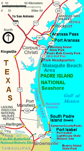
North Padre Island is a barrier island along the coast of Texas. It and South Padre Island were formed after the creation of the Port Mansfield Channel split Padre Island in two. From north to south, North Padre Island is located in parts of Nueces, Kleberg, Kenedy, and Willacy counties. The northernmost part of the island to the Kleberg County line is part of the city of Corpus Christi. Corpus Christi The upper portion of North Padre Island is a district of the city of Corpus Christi. "The Island" as known by locals consists of high-income residential housing and condominiums and is a popular fishing destination. The Packery Channel, an inlet which connects the Gulf of Mexico to the Laguna Madre, separates North Padre Island from Mustang Island. There are numerous hotels located on North Padre Island, either along the beach or near the intersection of Texas Highway 361 and Texas Park Road 22, the district's two only main thoroughfares. Boating is also a popular activity on t ... [...More Info...] [...Related Items...] OR: [Wikipedia] [Google] [Baidu] |
Padre Island 0001
{{disambiguation, geo ...
__NOTOC__ Padre means father in many Romance languages, and it may also refer to: Music * "Padre" (song) People * A military chaplain * A Latin Catholic priest * A member of the San Diego Padres baseball team Places * Padre Island, a barrier island in the U.S. State of Texas * North Padre Island, northern part of the Padre Island * South Padre Island, southern part of the Padre Island * Padre Island National Seashore Software * Padre (software), an integrated development environment for the Perl programming language Others * PADRE, Partnership for Acid Drainage Remediation in Europe * ''The Padre'', a 2018 film See also *Padres (other) The San Diego Padres are a Major League Baseball team based in San Diego, California. Padres may also refer to * Padres workers at the Spanish missions in California *PADRES, a Chicano priests' organization *Tucson Padres, a minor league baseball t ... [...More Info...] [...Related Items...] OR: [Wikipedia] [Google] [Baidu] |
Corpus Christi, Texas
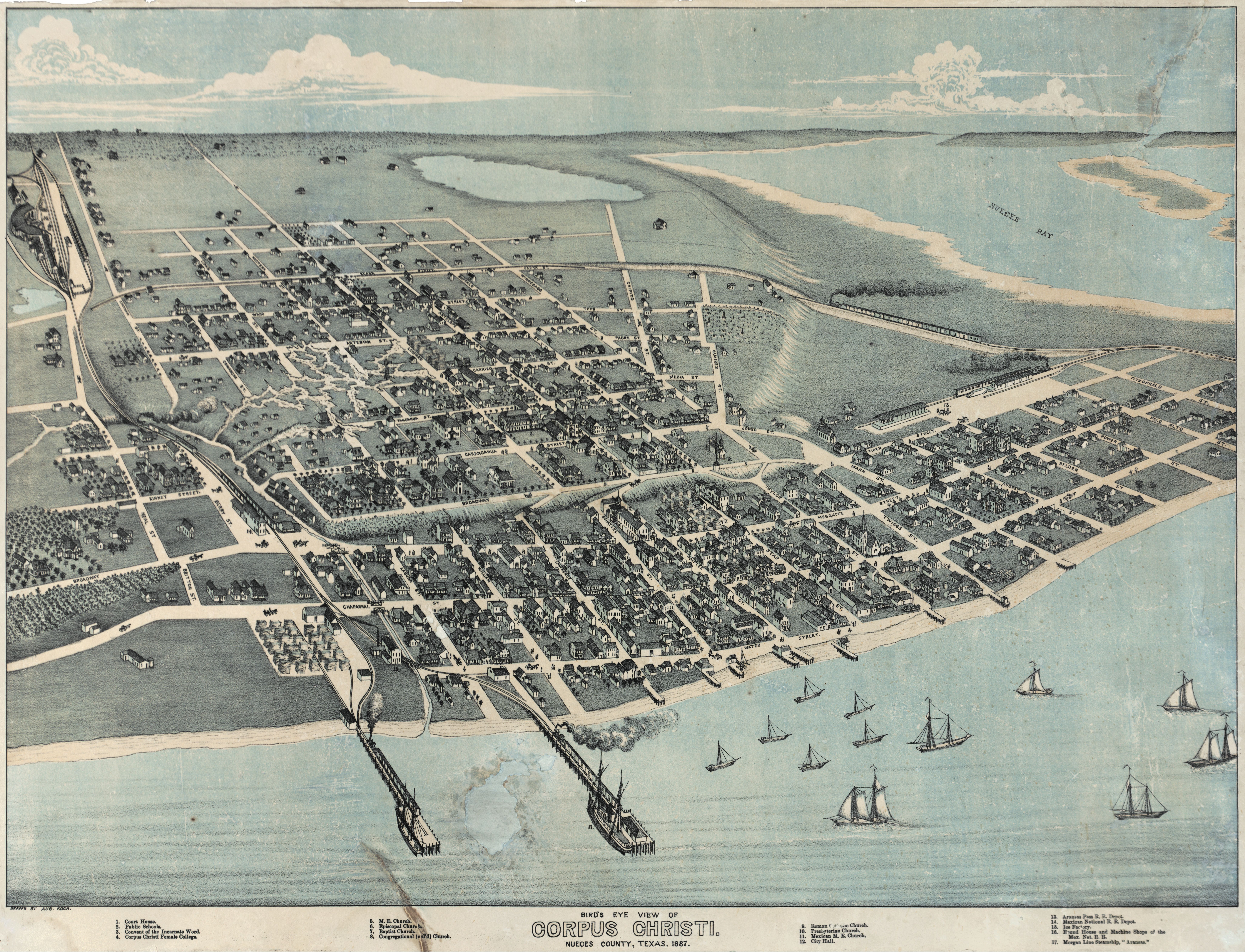
Corpus Christi (; Ecclesiastical Latin: "'' Body of Christ"'') is a coastal city in the South Texas region of the U.S. state of Texas and the county seat and largest city of Nueces County, it also extends into Aransas, Kleberg, and San Patricio Counties. It is southeast of San Antonio. Its political boundaries encompass Nueces Bay and Corpus Christi Bay. Its zoned boundaries include small land parcels or water inlets of three neighboring counties. The city's population was 317,863 in 2020, making it the eighth-most populous city in Texas. The Corpus Christi metropolitan area had an estimated population of 442,600. It is also the hub of the six-county Corpus Christi-Kingsville Combined Statistical Area, with a 2013 estimated population of 516,793. The Port of Corpus Christi is the fifth-largest in the United States. The region is served by the Corpus Christi International Airport. The city's name means body of Christ in Ecclesiastical Latin, in reference to the Christian sac ... [...More Info...] [...Related Items...] OR: [Wikipedia] [Google] [Baidu] |
Islands Of Nueces County, Texas
An island or isle is a piece of subcontinental land completely surrounded by water. Very small islands such as emergent land features on atolls can be called islets, skerries, cays or keys. An island in a river or a lake island may be called an eyot or ait, and a small island off the coast may be called a holm. Sedimentary islands in the Ganges Delta are called chars. A grouping of geographically or geologically related islands, such as the Philippines, is referred to as an archipelago. There are two main types of islands in the sea: continental islands and oceanic islands. There are also artificial islands (man-made islands). There are about 900,000 official islands in the world. This number consists of all the officially-reported islands of each country. The total number of islands in the world is unknown. There may be hundreds of thousands of tiny islands that are unknown and uncounted. The number of sea islands in the world is estimated to be more than 200,000. The t ... [...More Info...] [...Related Items...] OR: [Wikipedia] [Google] [Baidu] |
Landforms Of Kleberg County, Texas
A landform is a natural or anthropogenic land feature on the solid surface of the Earth or other planetary body. Landforms together make up a given terrain, and their arrangement in the landscape is known as topography. Landforms include hills, mountains, canyons, and valleys, as well as shoreline features such as bays, peninsulas, and seas, including submerged features such as mid-ocean ridges, volcanoes, and the great ocean basins. Physical characteristics Landforms are categorized by characteristic physical attributes such as elevation, slope, orientation, stratification, rock exposure and soil type. Gross physical features or landforms include intuitive elements such as berms, mounds, hills, ridges, cliffs, valleys, rivers, peninsulas, volcanoes, and numerous other structural and size-scaled (e.g. ponds vs. lakes, hills vs. mountains) elements including various kinds of inland and oceanic waterbodies and sub-surface features. Mountains, hills, plateaux, and plains are the fo ... [...More Info...] [...Related Items...] OR: [Wikipedia] [Google] [Baidu] |
Landforms Of Kenedy County, Texas
A landform is a natural or anthropogenic land feature on the solid surface of the Earth or other planetary body. Landforms together make up a given terrain, and their arrangement in the landscape is known as topography. Landforms include hills, mountains, canyons, and valleys, as well as shoreline features such as bays, peninsulas, and seas, including submerged features such as mid-ocean ridges, volcanoes, and the great ocean basins. Physical characteristics Landforms are categorized by characteristic physical attributes such as elevation, slope, orientation, stratification, rock exposure and soil type. Gross physical features or landforms include intuitive elements such as berms, mounds, hills, ridges, cliffs, valleys, rivers, peninsulas, volcanoes, and numerous other structural and size-scaled (e.g. ponds vs. lakes, hills vs. mountains) elements including various kinds of inland and oceanic waterbodies and sub-surface features. Mountains, hills, plateaux, and plains are the fou ... [...More Info...] [...Related Items...] OR: [Wikipedia] [Google] [Baidu] |
Landforms Of Corpus Christi, Texas
A landform is a natural or anthropogenic land feature on the solid surface of the Earth or other planetary body. Landforms together make up a given terrain, and their arrangement in the landscape is known as topography. Landforms include hills, mountains, canyons, and valleys, as well as shoreline features such as bays, peninsulas, and seas, including submerged features such as mid-ocean ridges, volcanoes, and the great ocean basins. Physical characteristics Landforms are categorized by characteristic physical attributes such as elevation, slope, orientation, stratification, rock exposure and soil type. Gross physical features or landforms include intuitive elements such as berms, mounds, hills, ridges, cliffs, valleys, rivers, peninsulas, volcanoes, and numerous other structural and size-scaled (e.g. ponds vs. lakes, hills vs. mountains) elements including various kinds of inland and oceanic waterbodies and sub-surface features. Mountains, hills, plateaux, and plains are the fou ... [...More Info...] [...Related Items...] OR: [Wikipedia] [Google] [Baidu] |
Padre Island National Seashore
Padre Island National Seashore (PINS) is a national seashore located on Padre Island off the coast of South Texas. In contrast to South Padre Island, known for its beaches and vacationing college students, PINS is located on North Padre Island and consists of a long beach where nature is preserved. Most of the park is primitive, but camping is available, and most of the beach is only accessible to four-wheel-drive vehicles. All but four miles is open to vehicle traffic. PAIS is the fourth designated national seashore in the United States.David Sikes of ''Corpus Christi Caller-Times'', "Padre Island seashore marks 50th", ''Laredo Morning Times'', December 3, 2012, p. 3A North Padre Island is the longest undeveloped barrier island in the world. The national seashore is long with of Gulf beach. PAIS hosts a variety of pristine beach, dune, and tidal flat environments, including the Laguna Madre on its west coast, a famous spot for windsurfing. It is located in parts of Kleberg, ... [...More Info...] [...Related Items...] OR: [Wikipedia] [Google] [Baidu] |
Mustang Island
Mustang Island is a barrier island on the Gulf Coast of Texas in the United States. The island is 18 miles (29 km) long, stretching from Corpus Christi to Port Aransas. The island is oriented generally northeast–southwest, with the Gulf of Mexico on the east and south, and Corpus Christi Bay on the north and west. The island's southern end connects by roadway to Padre Island. At the northern end of the island is Port Aransas, beyond which is San José Island. The Aransas Channel, also known as the "Aransas Pass," which separates Mustang Island from San José Island, is protected by jetties extending into the Gulf from each island. The town of Port Aransas is located at the northern end of the island. Mustang Island State Park encompasses the entire southern third of the island, including 3,955 acres (1,600 ha) and 5 miles (8 km) of beach. The city of Corpus Christi includes the northernmost portion of Padre Island and part of Mustang Island between Port Arans ... [...More Info...] [...Related Items...] OR: [Wikipedia] [Google] [Baidu] |
Laguna Madre
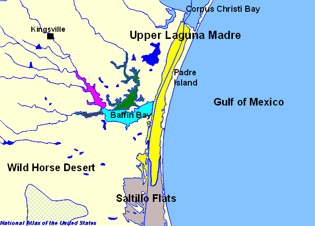
The Laguna Madre is a long, shallow, hypersaline lagoon along the western coast of the Gulf of Mexico in Nueces, Kenedy, Kleberg, Willacy and Cameron Counties in Texas, United States. It is one of seven major estuaries along the Gulf Coast of Texas. The roughly long Saltillo Flats land bridge divides it into Upper and Lower lagoons joined by the Intracoastal Waterway, which has been dredged through the lagoon. Cumulatively, Laguna Madre is approximately long, the length of Padre Island in the US. The main extensions include Baffin Bay in Upper Laguna Madre, Red Fish Bay just below the Saltillo Flats, and South Bay near the Mexican border. As a natural ecological unit, the Laguna Madre of the United States is the northern half of the ecosystem as a whole, which extends into Tamaulipas, Mexico approximately south of the US border, to the vicinity of the Rio Soto La Marina and the town of La Pesca, extending approximately through USA and Mexico in total.Tunnell, Jr. John ... [...More Info...] [...Related Items...] OR: [Wikipedia] [Google] [Baidu] |
Willacy County, Texas
Willacy County is a county in the U.S. state of Texas. As of the 2020 census, its population was 20,164. Its county seat is Raymondville. The county was created in 1911 and organized the next year. Willacy County comprises the Raymondville micropolitan statistical area, which is included in the Brownsville-Harlingen-Raymondville combined statistical area, which itself is part of the larger Rio Grande Valley region. History Willacy County was formed in 1911 from parts of Cameron and Hidalgo Counties, and originally included what is now Kenedy County; it was named for state senator John G. Willacy. Kenedy was split from Willacy in 1921, when the long-settled ranchers of the northern (Kenedy) part of the county sought to separate from the newly arrived farmers of the southern part. The Bermuda onion was introduced to Willacy County in 1912. It grew well and slowly displaced ranchland in the southern part of the county, becoming the most important crop. For many years, th ... [...More Info...] [...Related Items...] OR: [Wikipedia] [Google] [Baidu] |
Barrier Island
Barrier islands are coastal landforms and a type of Dune, dune system that are exceptionally flat or lumpy areas of sand that form by wave and tidal action parallel to the mainland coast. They usually occur in chains, consisting of anything from a few islands to more than a dozen. They are subject to change during storms and other action, but absorb energy and protect the coastlines and create areas of protected waters where wetlands may flourish. A barrier chain may extend uninterrupted for over a hundred kilometers, excepting the tidal inlets that separate the islands, the longest and widest being Padre Island of Texas, United States. Sometimes an important inlet may close permanently, transforming an island into a peninsula, thus creating a barrier peninsula, often including a beach, barrier beach. The length and width of barriers and overall morphology of barrier coasts are related to parameters including tidal range, wave energy, Sediment transport, sediment supply, Sea leve ... [...More Info...] [...Related Items...] OR: [Wikipedia] [Google] [Baidu] |
Kenedy County, Texas
Kenedy County is a county located in the U.S. state of Texas. As of the 2020 census, its population was 350. It is the third-least populous county in Texas and fourth-least populous in the United States. Its county seat is Sarita. The county was created in 1921 from parts of Hidalgo and Willacy counties and is named for Mifflin Kenedy, an early area rancher and steamboat operator. Kenedy County is included in the Kingsville, TX Kingsville Micropolitan Statistical Area, which is also included in the Corpus Christi-Kingsville- Alice, TX Combined Statistical Area. There are no incorporated municipalities in Kenedy County. In 1999, Hurricane Bret struck the county, but damage was minimal due to the sparse population. The Peñascal Wind Power Project was built near Sarita in the early 21st Century and is expected to slightly raise the population of the area. The King Ranch, of which Mifflin Kenedy had been a partner prior to 1868, covers a large part of the county. Geograp ... [...More Info...] [...Related Items...] OR: [Wikipedia] [Google] [Baidu] |


.jpg)

