|
Nishitama, Tokyo
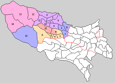
is a district located in Tokyo Metropolis, Japan. It comprises the following three towns and a village: * Hinode *Mizuho *Okutama * Hinohara Historically, the cities of Ōme, Fussa, Hamura, and Akiruno were part of Nishitama District but these have broken off from the district after they were elevated to city status. Education Each of the towns and villages operate separate public elementary and junior high school systems. Tokyo Metropolitan Government Board of Education operates Mizuho Nougei High School in Mizuho. The school district also operates the following high schools in nearby Ōme: * Norin High School * Ome Sogo High School * Tama High School The district operates the following high schools in Fussa: * Fussa High School * Tama Technical High School The district operates Hamura High School in Hamura. The district operates the following schools in Akiruno: * Akirudai High School * Itsukaichi High School District timeline * July 22, 1878: Tama District, whi ... [...More Info...] [...Related Items...] OR: [Wikipedia] [Google] [Baidu] |
Districts Of Japan
In Japan, a is composed of one or more rural municipalities (Towns of Japan, towns or Villages of Japan, villages) within a Prefectures of Japan, prefecture. Districts have no governing function, and are only used for geographic or statistical purposes such as mailing addresses. Cities of Japan, Cities are not part of districts. Historically, districts have at times functioned as an administrative unit in Japan, administrative unit. From 1878 to 1921The governing law, the district code (''gunsei'', 郡制Entry for the 1890 originalanentry for the revised 1899 ''gunsei''in the National Diet Library ''Nihon hōrei sakuin''/"Index of Japanese laws and ordinances"), was abolished in 1921, but the district assemblies (''gunkai'', 郡会) existed until 1923, the district chiefs (''gunchō'', 郡長) and district offices (''gun-yakusho'', 郡役所) until 1926. district governments were roughly equivalent to a County (United States), county of the United States, ranking below Prefectu ... [...More Info...] [...Related Items...] OR: [Wikipedia] [Google] [Baidu] |
Mizuho Nougei High School
Mizuho () literally means "abundant rice" in Japanese and "harvest" in the figurative sense. It was also an ancient name of Japan. It might refer to: Places * Mizuho, Gifu, a city in Gifu * Mizuho, Tokyo, a town in Tokyo * Mizuho Plateau in Antarctica ** Mizuho Station (Antarctica) * Mizuho Township, former name during the Japanese colonial period of the town of Ruisui, Hualien in Taiwan People * Mizuho Ōta (1876–1955), Japanese poet * Mizuho Suzuki (born 1927), Japanese actor * Mizuho Fukushima (born 1955), Japanese female politician * Mizuho Aimoto (born 1964), Japanese female manga artist * Mizuho Yoshida (born 1965), Japanese actor * Mizuho Katayama (born 1969), female synchronized swimming coach in Japan who represented South Korea at the 1988 Olympics * Mizuho Kusanagi (born 1979), Japanese female manga artist *, Japanese long-distance runner * Mizuho Sakaguchi (born 1987), Japanese female association footballer * Mizuho Saito, member of the former Japanese band Zone ... [...More Info...] [...Related Items...] OR: [Wikipedia] [Google] [Baidu] |
Minamitama District, Tokyo
Minamitama (南多摩郡, ''Minamitama-gun'', South Tama) was a district or county (''gun'') of Tokyo Tokyo (; ja, 東京, , ), officially the Tokyo Metropolis ( ja, 東京都, label=none, ), is the capital and largest city of Japan. Formerly known as Edo, its metropolitan area () is the most populous in the world, with an estimated 37.468 ... (''Metropolis''/{refecture), Japan. It was created in the early Meiji era when the old Tama District, Musashi, Tama District of Musashi Province was divided into four parts and split between Kanagawa and Tokyo. It lost its status as an administrative unit in the 1920s when county governments and councils were abolished across the country. As a geographical unit, it ceased to exist in 1971 when its last two remaining municipalities were promoted to Cities of Japan, independent cities. History * Minamitama District was created in 1878 and initially consisted of more than 120 subdivisions. * When the modern municipality system was set ... [...More Info...] [...Related Items...] OR: [Wikipedia] [Google] [Baidu] |
Kitatama District, Tokyo
was a district located in the Japanese Prefecture of Kanagawa from 1878 to 1893 and then in the Prefecture of Tokyo until 1970. In 1878, the Meiji government made the first step to introduce modern administrative divisions on the municipal level: The districts (''gun'') were created from the pre-modern districts (''gun'' or ''kōri'') with their towns and villages. The old Tama District of Musashi Province was divided into four parts: Eastern Tama ( Higashitama) became part of Tokyo Prefecture and the three other districts of Northern Tama (Kitatama), Southern Tama ( Minamitama) and Western Tama ( Nishitama) part of Kanagawa Prefecture. In 1889 when the modern cities, towns and villages were incorporated, the communities of Northern Tama were organized into 39 municipalities: the town (initially ''-eki'', became ''machi'' in 1893) of Fuchū where the district government was set up, the towns of Chōfu and Tanashi and 37 villages. Four years later, in 1893, the three Western Tam ... [...More Info...] [...Related Items...] OR: [Wikipedia] [Google] [Baidu] |
Musashi Province
was a province of Japan, which today comprises Tokyo Metropolis, most of Saitama Prefecture and part of Kanagawa Prefecture. It was sometimes called . The province encompassed Kawasaki and Yokohama. Musashi bordered on Kai, Kōzuke, Sagami, Shimōsa, and Shimotsuke Provinces. Musashi was the largest province in the Kantō region. History Musashi had its ancient capital in modern Fuchū, Tokyo, and its provincial temple in what is now Kokubunji, Tokyo. By the Sengoku period, the main city was Edo, which became the dominant city of eastern Japan. Edo Castle was the headquarters of Tokugawa Ieyasu before the Battle of Sekigahara and became the dominant city of Japan during the Edo period, being renamed Tokyo during the Meiji Restoration. ''Hikawa-jinja'' was designated as the chief Shinto shrine (''ichinomiya'') of the province; and there are many branch shrines. The former province gave its name to the battleship of the Second World War. Timeline of important events * ... [...More Info...] [...Related Items...] OR: [Wikipedia] [Google] [Baidu] |
Tama District, Musashi
Tama may mean: Languages * Tama language, the language of the Sudanese Tama people * Tama languages, a language family of northern Papua New Guinea Music * Tama Drums, a Japanese brand manufactured by Hoshino Gakki * Tama (percussion), a type of talking drum from West Africa * "Tama", a song by Mory Kanté People * Tama Hochbaum (born 1953), American artist and photographer * Tama people, an ethnic group in Chad and Sudan * La Tama, previously Ocute, a Native American people of the U.S. state of Georgia * Tama, the ring name of professional wrestler Sam Fatu * Tama, clan of junior Kazakh Jüz "horde", numbering ca. 70–115,000 * Tama people (Colombia), an indigenous group of Colombia Places * Tama, Iowa, United States * Tama County, Iowa, United States * Tama, Niger * Tama, La Rioja, Argentina * Tama, Musashi (), an old district in Musashi Province, Japan ** Tama Area (), the western portion of Tokyo Prefecture *** Tama Cemetery, the largest municipal cemetery in Japan *** T ... [...More Info...] [...Related Items...] OR: [Wikipedia] [Google] [Baidu] |
Hamura High School
is a city located in the western portion of Tokyo Metropolis, Japan. , the city had an estimated population of 54,622, and a population density of 5500 persons per km². The total area of the city was . Geography Hamura is approximately in the west-center of Tokyo Metropolis, on the Musashino Terrace. It flanks the Tama River about upriver from the mouth. Hamura is composed of the following neighborhoods: Fujimidaira, Futabacho, Gonokami, Hane, Hanehigashi, Kawasaki, Midorigaoka, Ozakudai, Shinmeidai, Tamagawa, Yokotakichinai. Surrounding municipalities Tokyo Metropolis * Ōme *Akiruno *Fussa *Mizuho Climate Hamura has a Humid subtropical climate (Köppen ''Cfa'') characterized by warm summers and cool winters with light to no snowfall. The average annual temperature in Hamura is 13.4 °C. The average annual rainfall is 1998 mm with September as the wettest month. The temperatures are highest on average in August, at around 25.0 °C, and lowest in January, at a ... [...More Info...] [...Related Items...] OR: [Wikipedia] [Google] [Baidu] |
Tama Technical High School
Tama may mean: Languages * Tama language, the language of the Sudanese Tama people * Tama languages, a language family of northern Papua New Guinea Music * Tama Drums, a Japanese brand manufactured by Hoshino Gakki * Tama (percussion), a type of talking drum from West Africa * "Tama", a song by Mory Kanté People * Tama Hochbaum (born 1953), American artist and photographer * Tama people, an ethnic group in Chad and Sudan * La Tama, previously Ocute, a Native American people of the U.S. state of Georgia * Tama, the ring name of professional wrestler Sam Fatu * Tama, clan of junior Kazakh Jüz "horde", numbering ca. 70–115,000 * Tama people (Colombia), an indigenous group of Colombia Places * Tama, Iowa, United States * Tama County, Iowa, United States * Tama, Niger * Tama, La Rioja, Argentina * Tama, Musashi (), an old district in Musashi Province, Japan ** Tama Area (), the western portion of Tokyo Prefecture *** Tama Cemetery, the largest municipal cemetery in Japan *** ... [...More Info...] [...Related Items...] OR: [Wikipedia] [Google] [Baidu] |
Fussa High School
is a city located in the western portion of Tokyo Metropolis, Japan. , the city had an estimated population of 56,786, and a population density of 5600 persons per km². The total area of the city is . About one third of the city area is occupied by the United States Air Force Yokota Air Base, giving the city an effective population density of 8,782 persons per km2. Geography Fussa is approximately in the geographic center of Tokyo Metropolis, on the Musashino Terrace, bordered by the floodplains of the Tama River. The land slopes gently from north to south, with an elevation of 124 meters above sea level at the location of the city hall, which is almost at the geographic center of the city area. The highest elevation is 143.5 meters in the northeast, and the lowest is 104 meters in the southwest. The area along the river is home to many parks and almost 300 cherry blossom trees, recreational facilities and bicycle paths. Surrounding municipalities Tokyo Metropolis *Hamura *Ak ... [...More Info...] [...Related Items...] OR: [Wikipedia] [Google] [Baidu] |
Tama High School
Tama may mean: Languages * Tama language, the language of the Sudanese Tama people * Tama languages, a language family of northern Papua New Guinea Music * Tama Drums, a Japanese brand manufactured by Hoshino Gakki * Tama (percussion), a type of talking drum from West Africa * "Tama", a song by Mory Kanté People * Tama Hochbaum (born 1953), American artist and photographer * Tama people, an ethnic group in Chad and Sudan * La Tama, previously Ocute, a Native American people of the U.S. state of Georgia * Tama, the ring name of professional wrestler Sam Fatu * Tama, clan of junior Kazakh Jüz "horde", numbering ca. 70–115,000 * Tama people (Colombia), an indigenous group of Colombia Places * Tama, Iowa, United States * Tama County, Iowa, United States * Tama, Niger * Tama, La Rioja, Argentina * Tama, Musashi (), an old district in Musashi Province, Japan ** Tama Area (), the western portion of Tokyo Prefecture *** Tama Cemetery, the largest municipal cemetery in Japan *** T ... [...More Info...] [...Related Items...] OR: [Wikipedia] [Google] [Baidu] |


