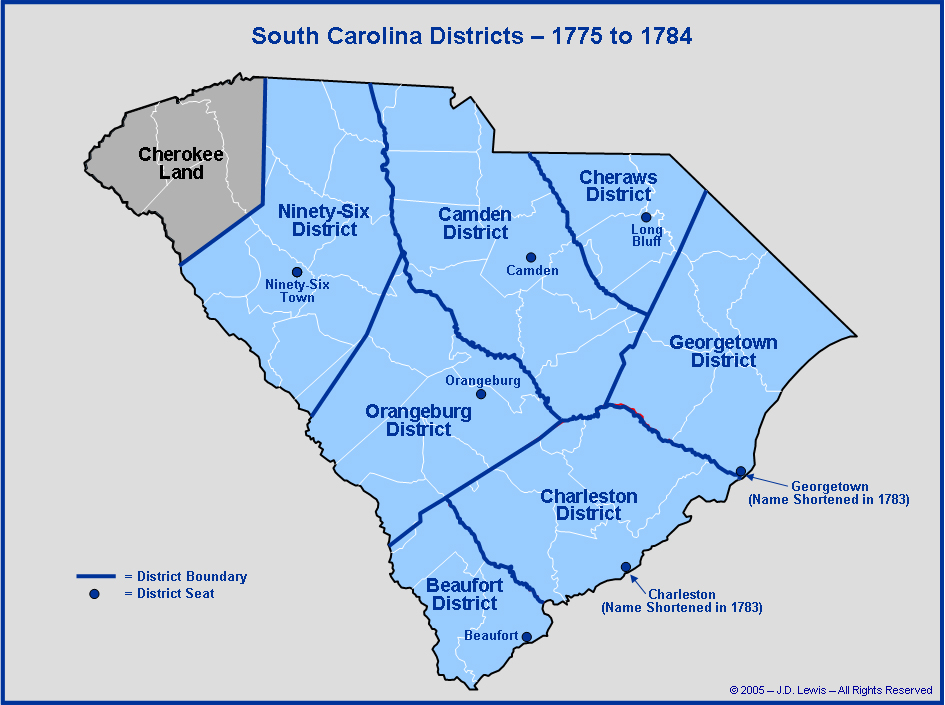
|
Ninety-Six District
Ninety-Six District (not "96th") is a former judicial district in the U.S. state of South Carolina. It existed as a district from 29 July 1769 to 31 December 1799. The court house and jail for Ninety-Six District were in Ninety Six, South Carolina. Colonial period In the colonial period, the land around the coast was divided into parishes corresponding to the parishes of the Church of England. There were also several counties that had judicial and electoral functions. As people settled the backcountry, judicial districts and additional counties were organized. This structure continued and grew after the Revolutionary War. In 1798, all counties were re-identified as "elective districts" to be effective on 1 January 1800. In 1868, the districts were converted back to counties. The South Carolina Department of Archives and History has maps that show the boundaries of counties, districts, and parishes starting in 1682. Ninety-Six District was created on 29 July 1769, as the most weste ... [...More Info...] [...Related Items...] OR: [Wikipedia] [Google] [Baidu] |
South Carolina
)''Animis opibusque parati'' ( for, , Latin, Prepared in mind and resources, links=no) , anthem = " Carolina";" South Carolina On My Mind" , Former = Province of South Carolina , seat = Columbia , LargestCity = Charleston , LargestMetro = Greenville (combined and metro) Columbia (urban) , BorderingStates = Georgia, North Carolina , OfficialLang = English , population_demonym = South Carolinian , Governor = , Lieutenant Governor = , Legislature = General Assembly , Upperhouse = Senate , Lowerhouse = House of Representatives , Judiciary = South Carolina Supreme Court , Senators = , Representative = 6 Republicans1 Democrat , postal_code = SC , TradAbbreviation = S.C. , area_rank = 40th , area_total_sq_mi = 32,020 , area_total_km2 = 82,932 , area_land_sq_mi = 30,109 , area_land_km2 = 77,982 , area_water_sq_mi = 1,911 , area_water_km2 = 4,949 , area_water_percent = 6 , population_rank = 23rd , population_as_of = 2022 , 2010Pop = 5282634 , population ... [...More Info...] [...Related Items...] OR: [Wikipedia] [Google] [Baidu] |
Cherokee
The Cherokee (; chr, ᎠᏂᏴᏫᏯᎢ, translit=Aniyvwiyaʔi or Anigiduwagi, or chr, ᏣᎳᎩ, links=no, translit=Tsalagi) are one of the indigenous peoples of the Southeastern Woodlands of the United States. Prior to the 18th century, they were concentrated in their homelands, in towns along river valleys of what is now southwestern North Carolina, southeastern Tennessee, edges of western South Carolina, northern Georgia, and northeastern Alabama. The Cherokee language is part of the Iroquoian language group. In the 19th century, James Mooney, an early American ethnographer, recorded one oral tradition that told of the tribe having migrated south in ancient times from the Great Lakes region, where other Iroquoian peoples have been based. However, anthropologist Thomas R. Whyte, writing in 2007, dated the split among the peoples as occurring earlier. He believes that the origin of the proto-Iroquoian language was likely the Appalachian region, and the split betw ... [...More Info...] [...Related Items...] OR: [Wikipedia] [Google] [Baidu] |
Former Counties, Districts, And Parishes Of South Carolina
A former is an object, such as a template, gauge or cutting die, which is used to form something such as a boat's hull. Typically, a former gives shape to a structure that may have complex curvature. A former may become an integral part of the finished structure, as in an aircraft fuselage, or it may be removable, being using in the construction process and then discarded or re-used. Aircraft formers Formers are used in the construction of aircraft fuselage, of which a typical fuselage has a series from the nose to the empennage, typically perpendicular to the longitudinal axis of the aircraft. The primary purpose of formers is to establish the shape of the fuselage and reduce the column length of stringers to prevent instability. Formers are typically attached to longerons, which support the skin of the aircraft. The "former-and-longeron" technique (also called stations and stringers) was adopted from boat construction, and was typical of light aircraft built until ... [...More Info...] [...Related Items...] OR: [Wikipedia] [Google] [Baidu] |
Siege Of Ninety-Six
The siege of Ninety Six was a siege in western South Carolina late in the American Revolutionary War. From May 22 to June 18, 1781, Continental Army Major General Nathanael Greene led 1,000 troops in a siege against the 550 Loyalists in the fortified village of Ninety Six, South Carolina. The 28-day siege centered on an earthen fortification known as Star Fort. Despite having more troops, Greene was unsuccessful in taking the town, and was forced to lift the siege when Lord Rawdon approached from Charleston with British troops. The area is now protected as Ninety Six National Historic Site and was designated a National Historic Landmark. Many of the surviving Loyalists were later relocated by the Crown and granted land in Nova Scotia, where they named their township Rawdon to commemorate their rescuer. Background The British Army's "southern strategy" for winning the American Revolutionary War, which had been successful in taking Charleston and winning submission of much o ... [...More Info...] [...Related Items...] OR: [Wikipedia] [Google] [Baidu] |
Ninety Six National Historic Site
Ninety Six National Historic Site, also known as Old Ninety Six and Star Fort, is a United States National Historic Site located about 60 miles (96 kilometers) south of Greenville, South Carolina. The historic site was listed on the National Register in 1969, declared to be a National Historic Landmark in 1973, and established as a National Historic Site in 1976 to preserve the original site of Ninety Six, South Carolina, a small town established in the early 18th century. It encompasses 1,022 acres of property. History The most common proposed etymology of the toponym Ninety Six is a reference to the distance in miles between the location and the Cherokee town of Keowee. Supporters of such an etymology have to struggle with the fact that the distance between the two locales is 78 miles. David P. George, Jr., has advanced the alternate hypothesis that Ninety Six is a reinterpretation of "the nine and six," a reference to two sets of southerly flowing streams—nine tributaries ... [...More Info...] [...Related Items...] OR: [Wikipedia] [Google] [Baidu] |
Bloody Bill Cunningham
William "Bloody Bill" Cunningham (1756–1787) was an American loyalist infamous for perpetrating a series of bloody massacres in South Carolina's backcountry in the fall of 1781 as commander of a Tory militia regiment in the Revolutionary War. Though his family were loyal to the British crown, Cunningham initially enlisted in the Continental Army as part of the State of South Carolina's 3rd regiment in 1775. His tenure in the rebel army was an unhappy one and Cunningham changed sides to fight for the British in 1778. He earned the nickname "Bloody Bill" for the violent, ruthless nature of his raids on rebels and patriot civilians. Background The Cunningham family emigrated from Scotland late in the 17th century, settling in Augusta County, Virginia. William was born in Virginia in 1756. When William was 10, the Cunningham family migrated to Ninety-Six, South Carolina, along the Saluda River in 1766, an area known for its fierce Whig-Tory rivalry that occasionally spilled int ... [...More Info...] [...Related Items...] OR: [Wikipedia] [Google] [Baidu] |
United States Congressman
The United States House of Representatives, often referred to as the House of Representatives, the U.S. House, or simply the House, is the lower chamber of the United States Congress, with the Senate being the upper chamber. Together they comprise the national bicameral legislature of the United States. The House's composition was established by Article One of the United States Constitution. The House is composed of representatives who, pursuant to the Uniform Congressional District Act, sit in single member congressional districts allocated to each state on a basis of population as measured by the United States Census, with each district having one representative, provided that each state is entitled to at least one. Since its inception in 1789, all representatives have been directly elected, although universal suffrage did not come to effect until after the passage of the 19th Amendment and the Civil Rights Movement. Since 1913, the number of voting representatives has ... [...More Info...] [...Related Items...] OR: [Wikipedia] [Google] [Baidu] |
James Augustus Black
James Augustus Black (1793 – April 3, 1848) was a slave owner, manufacturer, cotton broker, and U.S. Representative from South Carolina. Early life and military service Black was born on his father's plantation in the Ninety-Six District, near Abbeville, South Carolina. He attended the common schools on his father's plantation. Black served in the army during the War of 1812. He was appointed a second lieutenant in the Eighth Infantry on March 12, 1812. He was promoted to first lieutenant on December 2, 1813. After the war, Black was honorably discharged (June 15, 1815). Early career and a taste for politics Soon after returning to civilian life, Black co-founded the Kings Mountain Iron Works, which was involved in the mining of iron ore in areas near present-day Cherokee Falls, South Carolina. Black eventually moved to Georgia, settling in Savannah, where he engaged in the buying and selling of cotton. Black served as tax collector of Chatham County, Georgia for a ... [...More Info...] [...Related Items...] OR: [Wikipedia] [Google] [Baidu] |
1785 Act
Events January–March * January 1 – The first issue of the '' Daily Universal Register'', later known as '' The Times'', is published in London. * January 7 – Frenchman Jean-Pierre Blanchard and American John Jeffries travel from Dover, England to Calais, France in a hydrogen gas balloon, becoming the first to cross the English Channel by air. * January 11 – Richard Henry Lee is elected as President of the U.S. Congress of the Confederation.''Harper's Encyclopaedia of United States History from 458 A. D. to 1909'', ed. by Benson John Lossing and, Woodrow Wilson (Harper & Brothers, 1910) p167 * January 20 – Battle of Rạch Gầm-Xoài Mút: Invading Siamese forces, attempting to exploit the political chaos in Vietnam, are ambushed and annihilated at the Mekong River, by the Tây Sơn. * January 27 – The University of Georgia in the United States is chartered by the Georgia General Assembly meeting in Savannah. The first stud ... [...More Info...] [...Related Items...] OR: [Wikipedia] [Google] [Baidu] |
Tryon County, North Carolina
Tryon County is a former county which was located in the U.S. state of North Carolina. It was formed in 1768 from the part of Mecklenburg County west of the Catawba River, although the legislative act that created it did not become effective until April 10, 1769. Due to inaccurate and delayed surveying, Tryon County encompassed a large area of northwestern South Carolina."Tryon County, North Carolina History" by Alfred Nixon; 1910 It was named for , of the |
Treaty Of Lochaber
The Treaty of Lochaber was signed in South Carolina on 18 October 1770 by British representative John Stuart and the Cherokee people, fixing the boundary for the western limit of the colonial frontier settlements of Virginia and North Carolina. Lord Shelburne in London was determined to settle disputes along the western frontier in order to avoid more conflict between colonists and various Native American nations. Although he lost his office as Southern Secretary in October 1768, negotiations progressed with tribal chiefs (usually representing towns in their decentralized society) regarding the North American colonial frontier. The Treaty of Fort Stanwix in November 1768 fixed the boundary lines between tribes and colonists to the north of Virginia. The border variances from the Treaty of Hard Labour led to negotiations where 1000 Cherokee leaders were hosted by Alexander Cameron (d. 1781) at Lochabar Plantation in Ninety-Six District, South Carolina. Based on the terms of the ac ... [...More Info...] [...Related Items...] OR: [Wikipedia] [Google] [Baidu] |


