|
Newby And Scalby
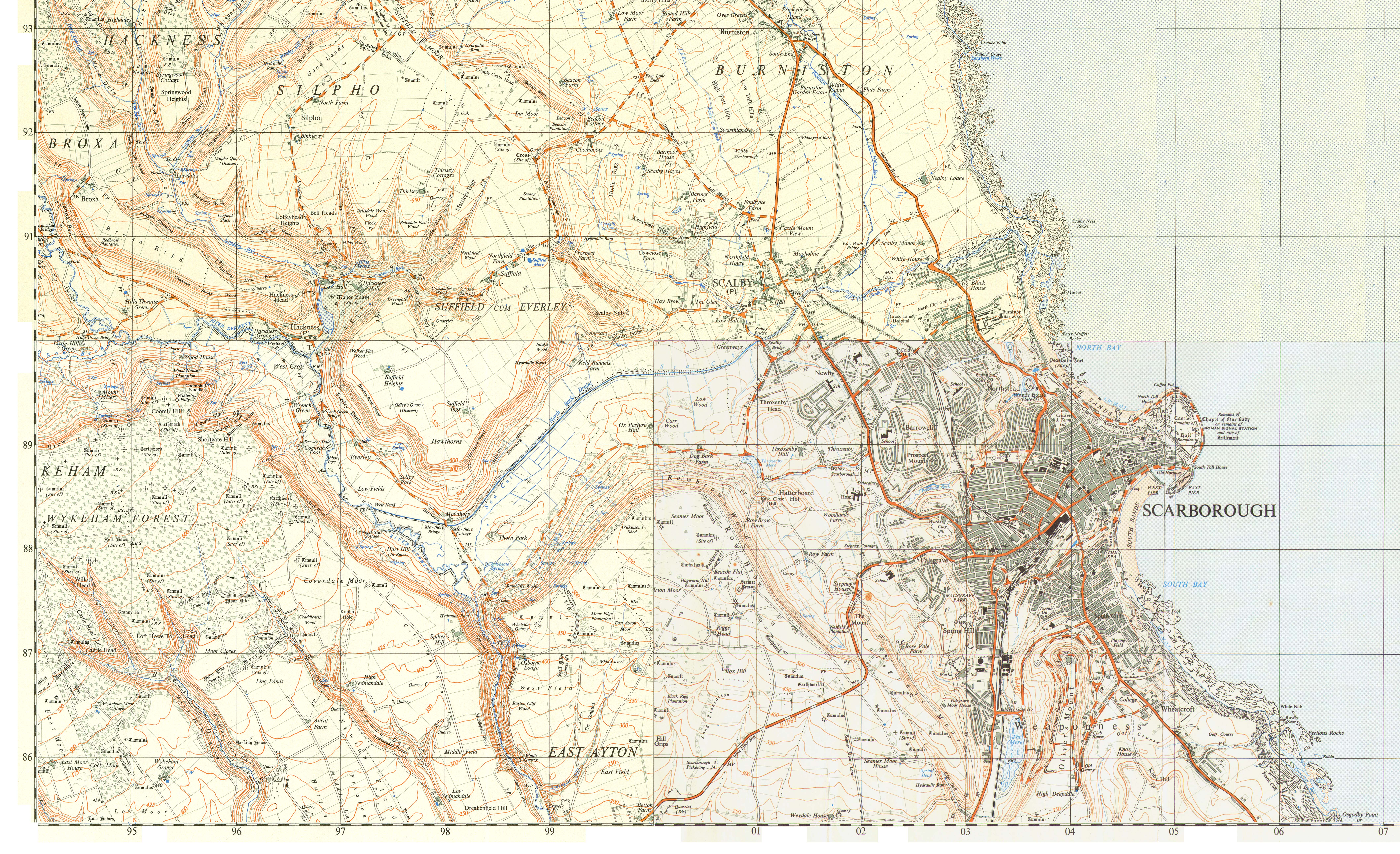
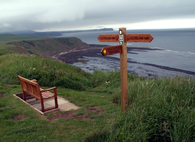
Newby and Scalby is a civil parish in the Scarborough (borough), Scarborough district of North Yorkshire, England, formed by the smaller southern area of Newby, Scarborough, Newby and the larger, northern, area of Scalby, North Yorkshire, Scalby. Geography The shape of the parish is a rectangle perpendicular to the coast, omitting the south-east corner which is the sea life centre and park of Scarborough, with a north-west rectangular projection most of which is closer to Burniston than Scalby. The village forms one large nucleated village, cluster in the mid-south of this area traversed by several small roads and passing through is a section of the relatively minor A171 road, A171. Newby is south of the Sea Cut (Scalby Beck), Scalby Beck (or Sea Cut) and is physically undivided from the rest of Scarborough. The coast here is cliffs topped by the Cleveland Way including Scalby Ness. Demography According to the United Kingdom Census 2011, 2011 UK census, Newby and Scalby par ... [...More Info...] [...Related Items...] OR: [Wikipedia] [Google] [Baidu] |
United Kingdom Census 2011
A Census in the United Kingdom, census of the population of the United Kingdom is taken every ten years. The 2011 census was held in all countries of the UK on 27 March 2011. It was the first UK census which could be completed online via the Internet. The Office for National Statistics (ONS) is responsible for the census in England and Wales, the General Register Office for Scotland (GROS) is responsible for the census in Scotland, and the Northern Ireland Statistics and Research Agency (NISRA) is responsible for the census in Northern Ireland. The Office for National Statistics is the executive office of the UK Statistics Authority, a non-ministerial department formed in 2008 and which reports directly to Parliament. ONS is the UK Government's single largest statistical producer of independent statistics on the UK's economy and society, used to assist the planning and allocation of resources, policy-making and decision-making. ONS designs, manages and runs the census in England an ... [...More Info...] [...Related Items...] OR: [Wikipedia] [Google] [Baidu] |
Sea Cut (Scalby Beck)
The Sea Cut (Scalby Beck)Also known as New Cut and Scalby Brook is a small river that enters the North Sea at Scalby Mills, Scarborough, North Yorkshire, England. The beck is fed from local streams in Scalby, Newby and Burniston and other watercourses draining off the nearby hills. It is also a bypass channel for the upper reaches of the River Derwent when it is under flood conditions. History The Sea Cut is fed by small streams and becks mainly draining water away from the hills on the western side of Scalby and Newby. In response to major flooding on the River Derwent in 1799, a canalised beck was cut between Everley and Newby Bridge (the present day A171 road bridge that spans the beck between Newby and Scalby). The Sea Cut was primarily to stop flooding in West and East Ayton further downstream. This means that water flowing in the River Derwent takes before reaching the sea via the Humber Estuary as opposed to the relatively short distance via the Sea Cut. This scheme, ... [...More Info...] [...Related Items...] OR: [Wikipedia] [Google] [Baidu] |
Scalby School
Scalby School is a Mixed-sex education, coeducational secondary school located in Scarborough, North Yorkshire, Scarborough, North Yorkshire, England. It caters for pupils aged 11–16, with around 980 on roll. History The school was built in 1942. In September 2002 the Department for Education and Skills (United Kingdom), Department for Education and Skills (DfES) awarded the school specialist school status as a Technology College. In January 2009 the school started to be advised by the Outwood Grange Academy, Outwood Grange College group of schools. A number of measures were introduced soon afterwards. In August 2009, the school achieved record results at GCSE, with some 61% achieving 5A*-C (including English and mathematics), the chief measure for English school league tables. This was a climb of 28% in one year, and placed the school top along the North Yorkshire coastal strip for raw results. In the same year there was a similar 5A*-C improvement, with the results reaching ... [...More Info...] [...Related Items...] OR: [Wikipedia] [Google] [Baidu] |
Scarborough Pirates ARLFC
Scarborough Pirates ARLFC was the name of an amateur rugby league team which competed in the Rugby League Conference Yorkshire Premier and British Amateur Rugby League Association winter leagues. The club was based in Scarborough, North Yorkshire, Scarborough, North Yorkshire, England. In a joint initiative with Breakaway Sports Tours, the Rugby Football League and Scarborough (borough), Scarborough Borough Council, the club established a rugby league nines tournament known as the Scarborough Rugby League Festival. History The Scarborough and District Primary Schools under-11s rugby league team, along with Glasgow Schools, was selected to play the curtain-raiser to the 2000 Challenge Cup Final at Murrayfield Stadium, Edinburgh on 29 April 2000. For several years, under-11s teams from non-traditional rugby league areas were selected by the RFL with the purpose of supporting the promotion of the sport. Enthused parents of the team decided to form the ''Scarborough Pirates'' ju ... [...More Info...] [...Related Items...] OR: [Wikipedia] [Google] [Baidu] |
Scarborough RUFC
Scarborough Rugby Union Football Club is an English rugby union club that is based in Scalby near Scarborough, North Yorkshire. The clubhouse is the UK's largest amateur clubhouse and is set within a 32-acre site with 5 senior pitches, a training pitch and 6 minis pitches. The club operates four senior men's teams, a women's team and pre-micro/micro/mini/youth rugby (ages 3–17). The men's 1st XV currently plays in Regional 2 NE – a league at level 6 of the English rugby union system – having been promoted into the division from Yorkshire 1 via a playoff at the end of the 2017–18 season. History Early years Scarborough RUFC was founded in 1926 following a meeting held at the Pavilion Hotel, and played its first ever game away to Whitby later that year. As the new club did not have its own ground, home fixtures during the 1926–27 season were played at Seamer Road ( Athletic Ground), with rent and a percentage of the gate money paid to the owners, Scarborough Footbal ... [...More Info...] [...Related Items...] OR: [Wikipedia] [Google] [Baidu] |
North York Moors National Park
North is one of the four compass points or cardinal directions. It is the opposite of south and is perpendicular to east and west. ''North'' is a noun, adjective, or adverb indicating direction or geography. Etymology The word ''north'' is related to the Old High German ''nord'', both descending from the Proto-Indo-European unit *''ner-'', meaning "left; below" as north is to left when facing the rising sun. Similarly, the other cardinal directions are also related to the sun's position. The Latin word ''borealis'' comes from the Greek '' boreas'' "north wind, north", which, according to Ovid, was personified as the wind-god Boreas, the father of Calais and Zetes. ''Septentrionalis'' is from ''septentriones'', "the seven plow oxen", a name of ''Ursa Major''. The Greek ἀρκτικός (''arktikós'') is named for the same constellation, and is the source of the English word ''Arctic''. Other languages have other derivations. For example, in Lezgian, ''kefer'' can mean b ... [...More Info...] [...Related Items...] OR: [Wikipedia] [Google] [Baidu] |
High Street
High Street is a common street name for the primary business street of a city, town, or village, especially in the United Kingdom and Commonwealth. It implies that it is the focal point for business, especially shopping. It is also a metonym for the retail sector. With the rapid increase in consumer expenditure the number of High Streets in England grew from the 17th century and reached a peak in Victorian Britain where, drawn to growing towns and cities spurred on by the Industrial Revolution, the rate of urbanisation was unprecedented. Since the latter half of the 20th century, the prosperity of High Streets has been in decline due to the growth of out-of-town shopping centres, and, since the early 21st century, the growth of online retailing, forcing many shop closures and prompting the UK government to consider initiatives to reinvigorate and preserve the High Street. High Street is the most common street name in the UK, which according to a 2009 statistical compilation ... [...More Info...] [...Related Items...] OR: [Wikipedia] [Google] [Baidu] |
Office For National Statistics
The Office for National Statistics (ONS; cy, Swyddfa Ystadegau Gwladol) is the executive office of the UK Statistics Authority, a non-ministerial department which reports directly to the UK Parliament. Overview The ONS is responsible for the collection and publication of statistics related to the economy, population and society of the UK; responsibility for some areas of statistics in Scotland, Northern Ireland and Wales is devolved to the devolved governments for those areas. The ONS functions as the executive office of the National Statistician, who is also the UK Statistics Authority's Chief Executive and principal statistical adviser to the UK's National Statistics Institute, and the 'Head Office' of the Government Statistical Service (GSS). Its main office is in Newport near the United Kingdom Intellectual Property Office and Tredegar House, but another significant office is in Titchfield in Hampshire, and a small office is in London. ONS co-ordinates data collection wi ... [...More Info...] [...Related Items...] OR: [Wikipedia] [Google] [Baidu] |
United Kingdom Census 2001
A nationwide census, known as Census 2001, was conducted in the United Kingdom on Sunday, 29 April 2001. This was the 20th UK census and recorded a resident population of 58,789,194. The 2001 UK census was organised by the Office for National Statistics (ONS) in England and Wales, the General Register Office for Scotland (GROS) and the Northern Ireland Statistics and Research Agency (NISRA). Detailed results by region, council area, ward and output area are available from their respective websites. Organisation Similar to previous UK censuses, the 2001 census was organised by the three statistical agencies, ONS, GROS, and NISRA, and coordinated at the national level by the Office for National Statistics. The Orders in Council to conduct the census, specifying the people and information to be included in the census, were made under the authority of the Census Act 1920 in Great Britain, and the Census Act (Northern Ireland) 1969 in Northern Ireland. In England and Wales these re ... [...More Info...] [...Related Items...] OR: [Wikipedia] [Google] [Baidu] |
Cleveland Way
The Cleveland Way is a National Trail in the historic area of Cleveland in North Yorkshire, northern England. It runs between Helmsley and the Brigg at Filey, skirting the North York Moors National Park. History Development of the Cleveland Way began in the 1930s when the Teesside Ramblers' Association pressed for the creation of a long-distance path in the north-east of Yorkshire linking the Hambleton Drove Road, the Cleveland escarpment and footpaths on the Yorkshire coast. Subsequently, in 1953, a formal proposal to create the route was submitted to the North Riding of Yorkshire Council by the National Parks Commission. The trail was officially opened in 1969. It was the second official National Trail to be opened. Route The trail can be walked in either direction linking the trailheads of Helmsley () and Filey () in a horseshoe configuration. The trail is waymarked along its length using the standard National Trail acorn symbol. The trail falls into two roughly equa ... [...More Info...] [...Related Items...] OR: [Wikipedia] [Google] [Baidu] |
A171 Road
The A171 is a road in England that links the North Yorkshire towns of Middlesbrough, Guisborough, Whitby, Robin Hood's Bay and Scarborough, North Yorkshire, Scarborough. Locally it is known as The Moor Road. The road is mostly single carriageway but has some sections of dual carriageway. The distance between the two towns is 47 miles (75 km) Settlements * Middlesbrough * Ormesby * Nunthorpe * Guisborough * Charltons * Scaling, North Yorkshire, Scaling * Whitby * Stainsacre * Hawsker * Cloughton * Burniston * Scalby, North Yorkshire, Scalby * Scarborough Description The road starts on the A66 at Middlesbrough (South Bank) and heads south east through Ormesby to Nunthorpe where it turns east as a dual carriageway bypassing Guisborough and the road becomes single carriageway again. Just outside Guisborough it heads into the North York Moors National Park (forming its boundary at first). As it passes the village of Charltons, it rises up at a 15% incline through two 90° t ... [...More Info...] [...Related Items...] OR: [Wikipedia] [Google] [Baidu] |
Scarborough (borough)
The Borough of Scarborough () is a non-metropolitan district and borough of North Yorkshire, England. In addition to the town of Scarborough, it covers a large stretch of the coast of Yorkshire, including Whitby and Filey. It borders Redcar and Cleveland to the north, the Ryedale and Hambleton districts to the west and the East Riding of Yorkshire to the south. The district was formed on 1 April 1974, under the Local Government Act 1972. It was a merger of the urban district of Filey and part of the Bridlington Rural District, from the historic East Riding of Yorkshire, along with the municipal borough of Scarborough, Scalby and Whitby urban districts, and Scarborough Rural District and Whitby Rural District, from the historic North Riding. In 2007, the borough was threatened with extinction. In March of that year, North Yorkshire County Council was shortlisted by the Department for Communities and Local Government to become a unitary authority. If the bid had been ... [...More Info...] [...Related Items...] OR: [Wikipedia] [Google] [Baidu] |


