|
New York Mountains
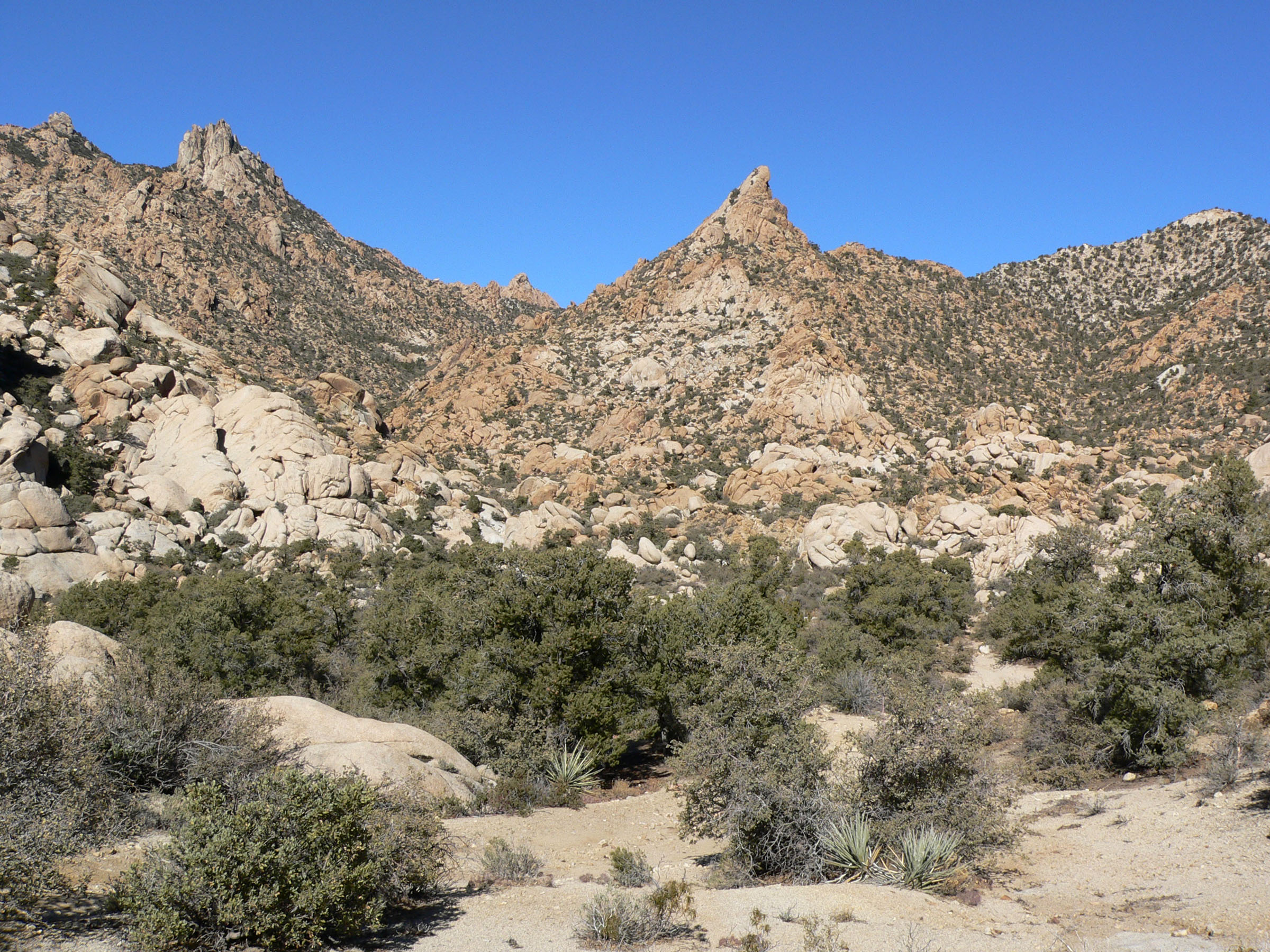
The New York Mountains are a small mountain range found in northeastern San Bernardino County in California, USA. The range's northeastern area lies in southeastern Nevada. The range lies just south of the small community of Ivanpah, and north of the Lanfair Valley. The mountains are part of the mountain ranges, cones, mountains, and landforms in the Mojave National Preserve. The mountains reach an elevation of , and run in a mostly southwest-northeasterly direction between the Providence Mountains and the McCullough Range approximately five miles into Nevada and border the northwest corner of the Piute Valley of Nevada-California. The New York Mountains are part of the southeast border of the Great Basin Divide. The Piute Wash Watershed empties eastward into the Colorado River. Description The New York Mountains are a southwest by northeast trending range, about long with the northeast in Nevada. Searchlight, Nevada and Cal-Nev-Ari, Nevada lie to the northeast and east, respe ... [...More Info...] [...Related Items...] OR: [Wikipedia] [Google] [Baidu] |
Ivanpah Valley
The Ivanpah Valley is in southeastern California and southern Nevada in the United States. The valley is between the New York Mountains and the Ivanpah Mountains in San Bernardino County on the California side, and in Clark County on the Nevada side. The communities of Cima, California; Nipton, California; Jean, Nevada; and Primm, Nevada are in the valley. The Ivanpah Dry Lake, a popular place for land sailing, and the site of the proposed Ivanpah Valley Airport also lie in the valley. The headwaters of the valley lie in the south and southeast in the north of the Mojave National Preserve; the southeast of the valley is a water divide point at the south of the McCullough Range, with four valleys, and four mountain ranges. (The Piute Valley drains southeast into the Colorado River; the Eldorado Valley northeast is endorheic.) See also * Ivanpah Solar Power Facility * Ivanpah Valley Airport *Lanfair Valley *Piute Valley The Piute Valley is a north–south valley southeast ... [...More Info...] [...Related Items...] OR: [Wikipedia] [Google] [Baidu] |
Great Basin Divide
The Great Basin Divide in the western United States is the ridgeline that separates the Great Basin from the Pacific Ocean watershed, which completely surrounds it. The Great Basin is the largest set of contiguous endorheic watersheds of North America, including six entire USGS watershed subregions. It contains the watersheds of several large prehistoric and still-existing lakes, most notably Lake Bonneville, Lake Lahontan, Lake Manly, and the Salton Sea. As such, it occupies most of present-day Nevada, about half of Utah, large parts of eastern California and Oregon, and small parts of Idaho, Wyoming, and Baja California. The arid climate of this area ensures that none of the major lake basins are filled to overflowing, and thus no precipitation falling into them reaches the sea. On the other hand, precipitation falling on the exterior of the Great Basin Divide does (theoretically) reach the Pacific Ocean, through a number of different channels. Roughly speaking, the area ... [...More Info...] [...Related Items...] OR: [Wikipedia] [Google] [Baidu] |
Mountain Ranges Of Southern California
A mountain is an elevated portion of the Earth's crust, generally with steep sides that show significant exposed bedrock. Although definitions vary, a mountain may differ from a plateau in having a limited summit area, and is usually higher than a hill, typically rising at least 300 metres (1,000 feet) above the surrounding land. A few mountains are isolated summits, but most occur in mountain ranges. Mountains are formed through tectonic forces, erosion, or volcanism, which act on time scales of up to tens of millions of years. Once mountain building ceases, mountains are slowly leveled through the action of weathering, through slumping and other forms of mass wasting, as well as through erosion by rivers and glaciers. High elevations on mountains produce colder climates than at sea level at similar latitude. These colder climates strongly affect the ecosystems of mountains: different elevations have different plants and animals. Because of the less hospitable terrain an ... [...More Info...] [...Related Items...] OR: [Wikipedia] [Google] [Baidu] |
Mountain Ranges Of Clark County, Nevada
A mountain is an elevated portion of the Earth's crust, generally with steep sides that show significant exposed bedrock. Although definitions vary, a mountain may differ from a plateau in having a limited summit area, and is usually higher than a hill, typically rising at least 300 metres (1,000 feet) above the surrounding land. A few mountains are isolated summits, but most occur in mountain ranges. Mountains are formed through tectonic forces, erosion, or volcanism, which act on time scales of up to tens of millions of years. Once mountain building ceases, mountains are slowly leveled through the action of weathering, through slumping and other forms of mass wasting, as well as through erosion by rivers and glaciers. High elevations on mountains produce colder climates than at sea level at similar latitude. These colder climates strongly affect the ecosystems of mountains: different elevations have different plants and animals. Because of the less hospitable terrain and ... [...More Info...] [...Related Items...] OR: [Wikipedia] [Google] [Baidu] |
Mountain Ranges Of San Bernardino County, California
A mountain is an elevated portion of the Earth's crust, generally with steep sides that show significant exposed bedrock. Although definitions vary, a mountain may differ from a plateau in having a limited summit area, and is usually higher than a hill, typically rising at least 300 metres (1,000 feet) above the surrounding land. A few mountains are isolated summits, but most occur in mountain ranges. Mountains are formed through tectonic forces, erosion, or volcanism, which act on time scales of up to tens of millions of years. Once mountain building ceases, mountains are slowly leveled through the action of weathering, through slumping and other forms of mass wasting, as well as through erosion by rivers and glaciers. High elevations on mountains produce colder climates than at sea level at similar latitude. These colder climates strongly affect the ecosystems of mountains: different elevations have different plants and animals. Because of the less hospitable terrain and ... [...More Info...] [...Related Items...] OR: [Wikipedia] [Google] [Baidu] |
Mountain Ranges Of The Mojave Desert
A mountain is an elevated portion of the Earth's crust, generally with steep sides that show significant exposed bedrock. Although definitions vary, a mountain may differ from a plateau in having a limited summit area, and is usually higher than a hill, typically rising at least 300 metres (1,000 feet) above the surrounding land. A few mountains are isolated summits, but most occur in mountain ranges. Mountains are formed through tectonic forces, erosion, or volcanism, which act on time scales of up to tens of millions of years. Once mountain building ceases, mountains are slowly leveled through the action of weathering, through slumping and other forms of mass wasting, as well as through erosion by rivers and glaciers. High elevations on mountains produce colder climates than at sea level at similar latitude. These colder climates strongly affect the ecosystems of mountains: different elevations have different plants and animals. Because of the less hospitable terrain a ... [...More Info...] [...Related Items...] OR: [Wikipedia] [Google] [Baidu] |
Ivanpah Mountains
The Ivanpah Mountains are located in the southeastern Mojave Desert of California in the United States. The range lies to the south and east of the Mescal Range and Clark Mountain Range. Paute Valley lies between the Ivanpahs and the Mescal Range and Wheaton Wash lies between the Ivanpahs and the Clark Mountains to the north. Interstate 15 traverses the Wheaton Wash to the north of the Ivanpahs. The Ivanpah Valley lies to the southeast with the New York Mountains beyond. The mountains lie in a general southwest-northeasterly direction, however Mineral Hill in the northeast part of the range lies at right angles to this trend.''Ivanpah, California—Nevada,'' 30x60 Minute Topographic Quadrangle, USGS, 1985 The mountains have had a rich mining history and are home to the Morning Star, Kokoweef, and Allured Mines among numerous others mostly worked in the late 19th and early 20th centuries. The southern part of the range lies in the Mojave National Preserve Mojave National Pr ... [...More Info...] [...Related Items...] OR: [Wikipedia] [Google] [Baidu] |
Piute Range
The Piute Range is located in the Mojave Desert, primarily in northeast San Bernardino County, California, United States, with a north portion in Nevada. Most of the range is the eastern border of the Mojave National Preserve, a National Park Service natural area and park. Geography The mountains lie to the east of Lanfair Valley and southeast of the New York Mountains and Castle Mountains (California), Castle Mountains, and northeast of the Piute Mountains. They trend in a north-south direction, and form the western perimeter of the north-south Piute Valley which extends north past Cal-Nev-Ari, Nevada, Cal-Nev-Ari to Searchlight, Nevada, Searchlight. History Fort Piute, one of a chain of military stations constructed to protect travellers on the Mojave Road from San Bernardino, California, San Bernardino across the Mojave Desert to Fort Mojave on the Colorado River, lies at the southeastern end of the range near Piute Spring (San Bernardino County, California), Piute Spring. 4- ... [...More Info...] [...Related Items...] OR: [Wikipedia] [Google] [Baidu] |
Castle Mountains (California)
The Castle Mountains are located in the Eastern Mojave Desert, in northeastern San Bernardino County, California and Clark County, Nevada. The range lies south and east of the New York Mountains, southwest of Searchlight and west of Cal-Nev-Ari, Nevada. The range lies at the northeastern end of the Lanfair Valley, and reaches an elevation of 5,543 feet above sea level at the summit of Hart Peak. The mountains lie in a southwest-northeasterly direction in both states, although most of the range is in California. The Piute Range lies to the southeast. Canadian NewCastle Gold Ltd. currently holds the rights to the Castle Mountain Mine Area, an open pit gold mine in the southern Castle Mountains. The company has the right to excavate nearly 10 million tons of ore through 2025. Due to low gold prices, however, mining has been suspended since 2001. [...More Info...] [...Related Items...] OR: [Wikipedia] [Google] [Baidu] |
Cal-Nev-Ari, Nevada
Cal-Nev-Ari is a census-designated place on U.S. Route 95 in Clark County, Nevada, United States, near the state's southernmost point. As of the 2010 census, the town had a population of 244. The town's name is a syllabic abbreviation of California, Nevada and Arizona. Cal-Nev-Ari was created in the mid-1960s by Nancy and Everette "Slim" Kidwell, who acquired a section of land from the U.S. government and commenced development of an airport-based community an hour by road from Las Vegas. In addition to the FAA-designated Kidwell Airport, the community has grown over the years to include a casino, motel, RV and mobile home parks, convenience market, and over 100 residential lots. The town was listed for sale in 2016 for $8 million although it had been originally listed in 2010 for $17 million. It sold for the $8 million price to Heart of Nature, an organic minerals company, which plans to use the water to manufacture sulfur products for farms. Geography Cal-Nev-Ari is located ... [...More Info...] [...Related Items...] OR: [Wikipedia] [Google] [Baidu] |
Searchlight, Nevada
Searchlight is an Unincorporated towns in Nevada, unincorporated town and census-designated place (CDP) in Clark County, Nevada, United States, at the topographic saddle between two mountain ranges. At the 2020 United States Census, 2020 census it had a population of 445. History According to United States Senate, U.S. Senator Harry Reid (1939-2021), who wrote extensively about his hometown, the most likely story as to how the town received its name was that when George Frederick Colton was looking for gold in the area on May 6, 1897, he supposedly said that it would take a searchlight to find gold ore there. Shortly thereafter, he found gold, leading to a boom era when Searchlight had a larger population than Las Vegas. At the time, it was in Lincoln County, Nevada. As talk surfaced for carving Clark County, Nevada out of Lincoln County, Searchlight was initially considered to be the county seat. Between 1907 and 1910, the gold mines produced $7 million in gold and other precious ... [...More Info...] [...Related Items...] OR: [Wikipedia] [Google] [Baidu] |
Caruthers Canyon 5
Caruthers () is a census-designated place (CDP) in Fresno County, California, United States. The population was 2,497 at the 2010 census, up from 2,103 at the 2000 census. Caruthers is located south of downtown Fresno, at an elevation of 246 feet (75 m). Geography According to the United States Census Bureau, the CDP has a total area of , all of it land. History The first post office in Caruthers opened in 1891. The name of the town honors W.A. Caruthers, a local farmer. Fresno County Public Library opened a branch in Caruthers in 1911, in the town's hotel. After moving to multiple locations, it occupied its current home in 2003, which is designed to emulate the look of a tank house and barn. Demographics 2010 At the 2010 census Caruthers had a population of 2,497. The population density was . The racial makeup of Caruthers was 1,224 (49.0%) White, 14 (0.6%) African American, 38 (1.5%) Native American, 221 (8.9%) Asian, 0 (0.0%) Pacific Islander, 904 (36.2%) from other races ... [...More Info...] [...Related Items...] OR: [Wikipedia] [Google] [Baidu] |


