|
Neretvanija
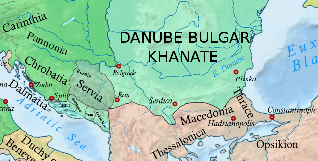
The Narentines were a South Slavic tribe that occupied an area of southern Dalmatia centered at the river Neretva (), active in the 9th and 10th centuries, noted as pirates on the Adriatic. Named ''Narentani'' in Venetian sources, Greek sources call them ''Paganoi'', "pagans", as they were for long pagan, in a time when neighbouring tribes were Christianized. The tribe were fierce enemies of the Republic of Venice, having attacked Venetian merchants and clergy passing on the Adriatic, and even raided close to Venice itself, as well as defeated the doge several times. Venetian–Narentine peace treaties did not last long, as the Narentines quickly returned to piracy. They were finally defeated in a Venetian crackdown at the turn of the 10th century and disappeared from sources by the 11th century. Terminology The word ''Narentine'' is a demonym derived from the local Neretva River ( lat, Narenta). The terms "Narentines", "Pagania" or "Pagans" are found in two contemporary source ... [...More Info...] [...Related Items...] OR: [Wikipedia] [Google] [Baidu] |
Conquest (military)
Conquest is the act of military subjugation of an enemy by force of arms. Military history provides many examples of conquest: the Roman conquest of Britain, the Mauryan conquest of Afghanistan and of vast areas of the Indian subcontinent, the Spanish conquest of the Aztec Empire and various Muslim conquests, to mention just a few. The Norman conquest of England provides an example: it built on cultural ties, led to the subjugation of the Kingdom of England to Norman control and brought William the Conqueror to the English throne in 1066. Conquest may link in some ways with colonialism. England, for example, experienced phases and areas of Anglo-Saxon, Viking and Franco-Norman colonisation and conquest. Methods of conquest The Ottomans used a method of gradual, non-military conquest in which they established suzerainty over their neighbours and then displaced their ruling dynasties. This concept was first systematized by Halil İnalcık. Conquests of this sort did no ... [...More Info...] [...Related Items...] OR: [Wikipedia] [Google] [Baidu] |
Makarska
Makarska (; it, Macarsca, ; german: Macharscha) is a town on the Adriatic coastline of Croatia, about southeast of Split (city), Split and northwest of Dubrovnik, in the Split-Dalmatia County. Makarska is a prominent regional tourist center, located on a horseshoe-shaped bay between the Biokovo mountains and the Adriatic Sea. The city is noted for its palm-fringed promenade, where cafes, bars and boutiques overlook the harbor. Adjacent to the beach are several large capacity hotels as well as a camping grounds. Makarska is the center of the Makarska Riviera, a popular tourist destination under the Biokovo mountain. It stretches for between the municipalities of Brela and Gradac, Split-Dalmatia County, Gradac. History Pre-history Near present-day Makarska, there was a settlement as early as the middle of the 2nd millennium BC. It is thought that it was a point used by the Cretans on their way up to the Adriatic (the so-called "amber road"). However it was only one of the po ... [...More Info...] [...Related Items...] OR: [Wikipedia] [Google] [Baidu] |
Duklja
Duklja ( sh-Cyrl, Дукља; el, Διόκλεια, Diokleia; la, Dioclea) was a medieval South Slavic state which roughly encompassed the territories of modern-day southeastern Montenegro, from the Bay of Kotor in the west to the Bojana River in the east, and to the sources of the Zeta and Morača rivers in the north. First mentioned in 10th– and 11th century Byzantine chronicles, it was a vassal of the Bulgarian Empire between 997 and 1018, and then of the Byzantine Empire until it became independent in 1040 under Stefan Vojislav ( 1034–43) who rose up and managed to take over territories of the earlier Serbian Principality, founding the Vojislavljević dynasty. Between 1043 and 1080, under Mihailo Vojislavljević ( 1050–81), and his son, Constantine Bodin ( 1081–1101), Duklja saw its apogee. Mihailo was given the nominal title ''King of Slavs'' by the Pope after having left the Byzantine camp and supported an uprising in the Balkans, in which his son Bodin playe ... [...More Info...] [...Related Items...] OR: [Wikipedia] [Google] [Baidu] |
Travunia
Travunia ( sh-Latn-Cyrl, separator=" / ", Travunija, Травунија; el, Τερβουνία, Tervounía; grc, Τερβουνία, Terbounía; la, Tribunia) was a South Slavic medieval principality that was part of Medieval Serbia (850–1371), and later the Medieval Bosnia (1373–1482). The principality became hereditary in a number of noble houses, often kin to the ruling dynasty. The region came under Ottoman rule in 1482. Its seat was in the city of Trebinje. In the 9th and 10th centuries, the ''Župa'' of Travunia was held by the Belojević noble family, who were entitled the rule during the reign of Prince Vlastimir (r. 830–850), of the Vlastimirović dynasty. After the death of Časlav, the last dynastic member, the principality disintegrated, and the provinces were annexed by the Bulgars and Byzantines. In 1034, Stefan Vojislav (the founder of the Vojislavljević dynasty) incited a rebellion and renounced Byzantine rule, becoming the ''Prince of Serbs'', rul ... [...More Info...] [...Related Items...] OR: [Wikipedia] [Google] [Baidu] |
Zachumlia
Zachlumia or Zachumlia ( sh-Latn-Cyrl, separator=" / ", Zahumlje, Захумље, ), also Hum, was a medieval principality located in the modern-day regions of Herzegovina and southern Dalmatia (today parts of Bosnia and Herzegovina and Croatia, respectively). In some periods it was a fully independent or semi-independent South Slavs, South Slavic principality. It maintained relations with various foreign and neighbouring powers (Byzantine Empire, First Bulgarian Empire, Kingdom of Croatia (medieval), Kingdom of Croatia, Principality of Serbia (early medieval), Principality of Serbia) and later was subjected (temporarily or for a longer period) to Kingdom of Hungary (1000–1301), Kingdom of Hungary, Kingdom of Serbia (medieval), Kingdom of Serbia, Kingdom of Bosnia, Duchy of Saint Sava and at the end to the Ottoman Empire. Etymology Zachlumia is a derivative of ''Hum'', from Proto-Slavic ''wikt:Appendix:Proto-Slavic/xъlmъ, *xŭlmŭ'', borrowed from a Germanic language (cf. Pr ... [...More Info...] [...Related Items...] OR: [Wikipedia] [Google] [Baidu] |
Lastovo
Lastovo (; it, Lagosta, german: Augusta, la, Augusta Insula, el, Ladestanos, Illyrian: ''Ladest'') is an island municipality A municipality is usually a single administrative division having corporate status and powers of self-government or jurisdiction as granted by national and regional laws to which it is subordinate. The term ''municipality'' may also mean the ... in the Dubrovnik-Neretva County in Croatia. The municipality consists of 46 islands with a total population of 792 people, of which 94,7% are ethnic Croats, and a land area of approximately . ''Lastovo Municipality Spatial Plan – Exposition of the Plan'', p. 4 The biggest island in the municipality is also named Lastovo, as is the largest town. The majority of the population lives on the island of Lastovo. Lastovo, like the rest of the Roman province of Dalmatia, was settled by Illyrians. The Romans conquered and settled the entire area, retaining control until the Pannonian Avars, Avar invasions and ... [...More Info...] [...Related Items...] OR: [Wikipedia] [Google] [Baidu] |
Vis (island)
Vis (; ; la, Issa, it, Lissa) is a small Croatian island in the Adriatic Sea. It is the farthest inhabited island off the Croatian mainland. Before the end of World War I, the island was held by the Liburnians, the Republic of Venice, the Napoleonic Kingdom of Italy, and the Austrian Empire. During the 19th century, the sea to the north of Vis was the site of two naval battles. In 1920, the island was ceded to the Kingdom of Yugoslavia as part of the Treaty of Rapallo. During World War II, the island was the headquarters of the Yugoslav Partisan movement. After the war, Vis was used as a naval base for the Yugoslav People's Army until 1989. The island's main industries are viticulture, fishing, fish processing, and tourism. Geography The farthest inhabited island off the Croatian mainland, Vis had a population of 3,617 in 2011. Vis has an area of . Its highest point is Hum, which is above sea level. The island's two largest settlements are the town of Vis on the island's ea ... [...More Info...] [...Related Items...] OR: [Wikipedia] [Google] [Baidu] |
Sušac
Sušac (, meaning ''dry island'', it, Cazza, la, Choasa) is a small rocky island in the Adriatic Sea with an area of 4.03 km2, and 16.4 km of coastline southwest of Korčula and Lastovo, on the halfway to the island of Vis, in Croatia , image_flag = Flag of Croatia.svg , image_coat = Coat of arms of Croatia.svg , anthem = "Lijepa naša domovino"("Our Beautiful Homeland") , image_map = , map_caption = , capit .... The coast consists of slopes and cliffs over 100 m tall, but the opposite side features a natural harbour. A 19th-century lighthouse is built on top of the island. The island is also known for its little lake, which is connected to the sea through a siphon 15 m deep. References External links Svjetionik Sušac Uninhabited islands of Croatia Islands of the Adriatic Sea Landforms of Split-Dalmatia County {{SplitDalmatia-geo-stub ... [...More Info...] [...Related Items...] OR: [Wikipedia] [Google] [Baidu] |
Brač
Brač is an island in the Adriatic Sea within Croatia, with an area of , making it the largest island in Dalmatia, and the third largest in the Adriatic. It is separated from the mainland by the Brač Channel, which is wide. The island's tallest peak, Vidova gora, or Mount St. Vid, stands at , making it the highest island point of the Adriatic islands. The island has a population of 13,931, living in twenty-two settlements, ranging from the main town Supetar, with more than 3,400 inhabitants, to Murvica, where less than two dozen people live. Brač Airport on Brač is the largest airport of all islands surrounding Split. Brač is known as a tourist destination, for the Zlatni Rat beach in Bol, the marina in Milna, the white limestone which was used for the palace of Diocletian, the stone mason school in Pučišća, the oldest preserved text written in the Croatian language, the author Vladimir Nazor, its olive oil with protected designation of origin, the Kopačina cave ne ... [...More Info...] [...Related Items...] OR: [Wikipedia] [Google] [Baidu] |
Hvar
Hvar (; Chakavian: ''Hvor'' or ''For'', el, Φάρος, Pharos, la, Pharia, it, Lesina) is a Croatian island in the Adriatic Sea, located off the Dalmatian coast, lying between the islands of Brač, Vis and Korčula. Approximately long, with a high east–west ridge of Mesozoic limestone and dolomite, the island of Hvar is unusual in the area for having a large fertile coastal plain, and fresh water springs. Its hillsides are covered in pine forests, with vineyards, olive groves, fruit orchards and lavender fields in the agricultural areas. The climate is characterized by mild winters, and warm summers with many hours of sunshine. The island has 10,739 residents according to the 2021 census, making it the 4th most populated of the Croatian islands. Hvar's location at the centre of the Adriatic sailing routes has long made this island an important base for commanding trade up and down the Adriatic, across to Italy and throughout the wider Mediterranean. It has been inhabite ... [...More Info...] [...Related Items...] OR: [Wikipedia] [Google] [Baidu] |
Mljet
Mljet (; la, Melita, it, Meleda) is the southernmost and easternmost of the larger Adriatic islands of the Dalmatia region of Croatia. The National Park includes the western part of the island, Veliko jezero, Malo jezero, Soline Bay and a sea belt 500 m wide from the most prominent cape of Mljet covering an area of 54 km2. The central parts of the park are Veliko jezero with the Isle of St. Mary, Malo jezero and the villages of Goveđari, Polače and Pomena.Naklad Naprijet, ''The Croatian Adriatic Tourist Guide'', pg. 338, Zagreb (1999), Population According to the 2011 census, Mljet has population of 1,088. Ethnic Croats make up 97.33% of the population. History Mljet was discovered by ancient Greco-Roman geographers, who wrote the first records and descriptions. The island was first described by Scylax of Caryanda in the 6th century BC; others prefer the text, Periplus of Pseudo-Scylax. In both texts, it is named Melite and supported by Apollonius of Rhodes.Bryant, Jacob ... [...More Info...] [...Related Items...] OR: [Wikipedia] [Google] [Baidu] |
Korčula
Korčula (, it, Curzola) is a Croatian island in the Adriatic Sea. It has an area of , is long and on average wide, and lies just off the Dalmatian coast. Its 15,522 inhabitants (2011) make it the second most populous Adriatic island after Krk. The population are almost entirely ethnic Croats (95.74%). The island is twinned with Rothesay in Scotland. Geography The island of Korčula belongs to the central Dalmatian archipelago, separated from the Pelješac peninsula by a narrow Strait of Pelješac, between wide. It stretches in the east–west direction, in length of ; on average, it is wide. With an area of , it is the sixth largest Adriatic island. The highest peaks are ''Klupca'', and ''Kom'', high. Main settlements on the island are towns of Korčula, Blato and Vela Luka. Villages along the coast are Brna, Račišće, Lumbarda and Prižba; Žrnovo, Pupnat, Smokvica and Čara are located inland. The island is divided into municipalities of Korčula, Smokvica, B ... [...More Info...] [...Related Items...] OR: [Wikipedia] [Google] [Baidu] |


