|
Ndian
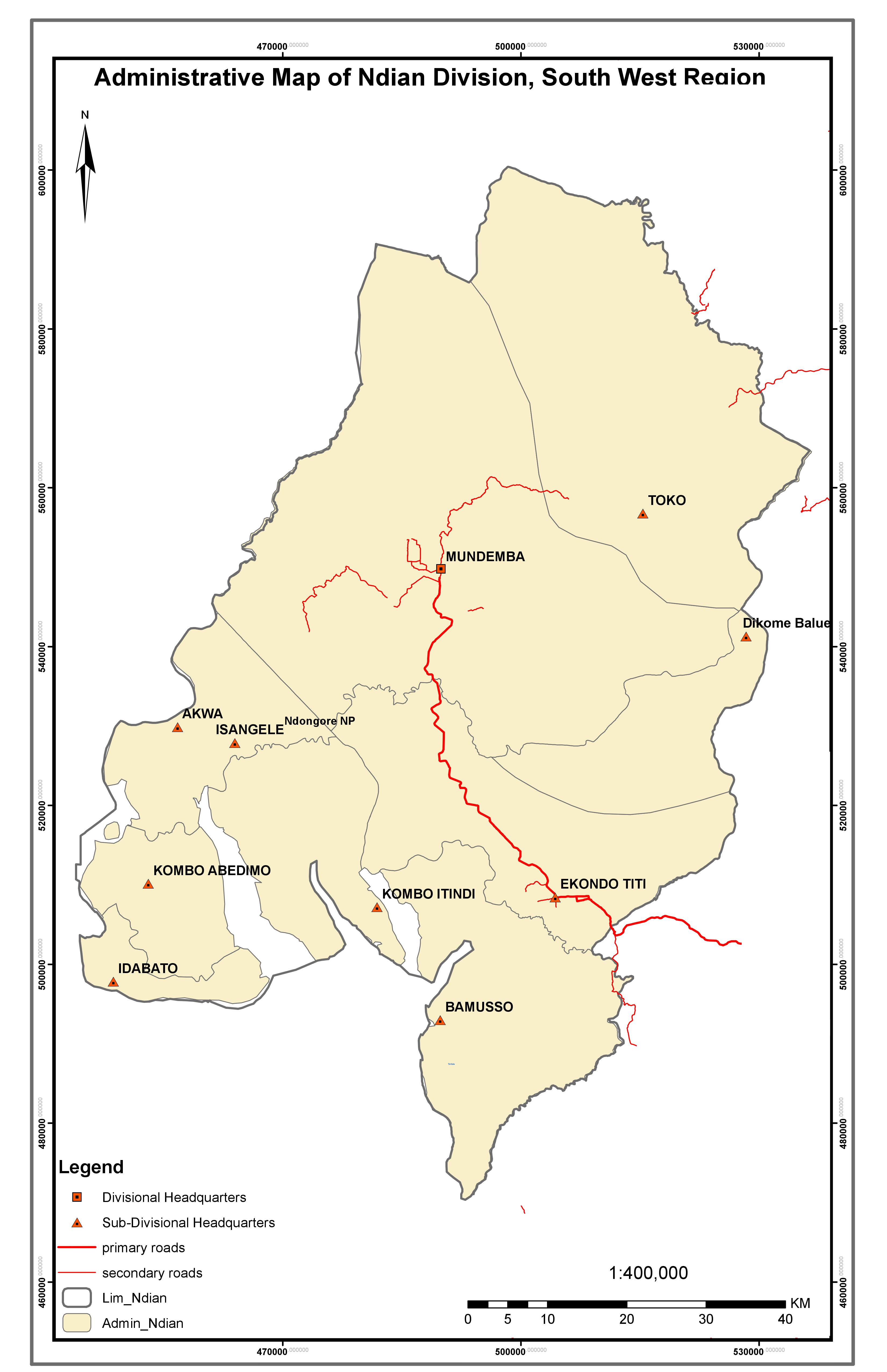
Ndian is a department of Southwest Region in Cameroon. It is located in the humid tropical rainforest zone about southeast of Yaoundé, the capital. History Ndian division was formed in 1975 from parts of Kumba and Victoria divisions and is one of six administrative units that constitute the Southwest Region. Its headquarters is in Mundemba and other major towns include Ekondo Titi, Bamusso, Isangele, Toko, Bekora and Dikome Balue. A total of nine municipalities (Bamusso, Dikome Balue, Ekondo Titi, Idabato, Isangele, Kumbo Abedimo, Kumbo Itindi, Mundemba and Toko) make up the division and spread across an estimated surface area of about (25% of the region). The division is linked to other major towns of Cameroon (such as Kumba in the Meme Division) by the national road N16 and which passes through Ekondo Titi onwards to Mundemba and Isangele. Geography The division borders the Federal Republic of Nigeria to the west, Fako division to the south, Manyu division to the n ... [...More Info...] [...Related Items...] OR: [Wikipedia] [Google] [Baidu] |
Communes Of Cameroon
The Arrondissements of Cameroon are the third-level units of administration in Cameroon. The arrondissements are organised by divisions and sub divisions of each province (now Regions). As of 2005 (and since 1996) there are 2 urban communities (Douala and Yaoundé) divided into 11 urban districts (5 in Douala and 6 in Yaounde), 9 towns with special status (Nkongsamba, Bafoussam, Bamenda, Limbe, Edéa, Ebolowa, Garoua, Maroua and Kumba Kumba is a metropolitan city in the Meme department, Southwest Region, Western Cameroon, referred as "K-town" in local slang. Kumba is the most developed and largest city in the Meme Department and has attracted people from the local villag ...), 11 urban communes and 305 rural communes. The councils are headed by mayors and municipal councillors who are elected. The councils have a responsibility in principle for the management of local affairs under the supervision of the State. Under Cameroonian law, the councils provide and re ... [...More Info...] [...Related Items...] OR: [Wikipedia] [Google] [Baidu] |
Mundemba
Mundemba is a town in Southwest Region, of Cameroon and the capital of the Ndian Division. The headquarters of Korup National Park are located in Mundemba. The separate village of Manja is nowadays practically an extension of Mundemba. People Mundemba was and still remains a predominantly Oroko settlement, but given the economic importance and administrative role of the town, many of the residents are from other local ethnic groups (i.e. Korup, Ejagham), and also the Anglophone North westerners, Francophone (esp. government employees), and people from Nigeria. with the population of about 80% youth. Economy The main employment opportunities in Mundemba revolve around agricultural goods (esp. palm oil), trading, and the public sector. Probably the biggest local employer iPAMOLPlantations, a public limited company that maintains a large African Oil Palm plantation adjacent to the township. Some sections of the local economy benefit from tourists visiting the renowned Korup N ... [...More Info...] [...Related Items...] OR: [Wikipedia] [Google] [Baidu] |
Ekondo-Titi
Ekondo-Titi is a commune and arrondissement in the Ndian department, Southwest Province, western Cameroon. Ekondo Titi is a suburban town and capital of the Ekondo Titi Sub Division. It is located in Ndian Division of the South West region of the Republic of Cameroon. The town is indigenous to the Balondo people in the coastal southwest region of Cameroon. Economy Being a suburban area, the economy is predominantly agricultural with a strong wave of plantation agriculture in the area. The leading agricultural state corporation PAMOL is located in Lobe Estate. There is an ample supply of food crops in the area. Transportation Ekondo Titi is a town with a manageable transport network that is adversely impacted by the rains during the wet seasons. History 2021 massacre On November 24, 2021, Anglophone gunmen stormed a bilingual school in the locality, killing five civilians, including one teacher and four children. 2022 bombing On March 2, 2022, Anglophone separatists bom ... [...More Info...] [...Related Items...] OR: [Wikipedia] [Google] [Baidu] |
Southwest Region, Cameroon
The Southwest Region or South-West Region () is a region in Cameroon. Its capital is Buea. , its population was 1,553,320. Along with the Northwest Region, it is one of the two Anglophone (English-speaking) regions of Cameroon. Various Ambazonian nationalist and separatist factions regard the ''Sud-Ouest'' region as being distinct as a polity from Cameroon. Administration The region is divided into six divisions or departments: Fako, Koupé-Manengouba, Lebialem, Manyu, Meme, and Ndian. These are in turn broken down into subdivisions. Presidentially appointed senior divisional officers () and subdivisional officers () govern each respectively. Ambazonian separatism Separatists from the Ambazonia administration regard both the Nord-Ouest (Northwest) and Sud-Ouest (Southwest) regions as being constituent components of their envisaged breakaway state. Geography The region was notable for having the first English-speaking university in Cameroon (the University of Buea). Towns in ... [...More Info...] [...Related Items...] OR: [Wikipedia] [Google] [Baidu] |
Idabato
Idabato is a commune and arrondissement in the Ndian département, Southwest Province, western Cameroon. See also *Communes of Cameroon The Arrondissements of Cameroon are the third-level units of administration in Cameroon. The arrondissements are organised by divisions and sub divisions of each province (now Regions). As of 2005 (and since 1996) there are 2 urban commu ... ReferencesMinistry of Territorial Administration and Decentralization - Southwest province Communes of Southwest Region (Cameroon) {{Cameroon-geo-stub ... [...More Info...] [...Related Items...] OR: [Wikipedia] [Google] [Baidu] |
Isanguele
Isanguele is a commune and arrondissement in the Ndian département, Southwest Province, western Cameroon. See also *Communes of Cameroon The Arrondissements of Cameroon are the third-level units of administration in Cameroon. The arrondissements are organised by divisions and sub divisions of each province (now Regions). As of 2005 (and since 1996) there are 2 urban commu ... ReferencesMinistry of Territorial Administration and Decentralization - Southwest province Communes of Southwest Region (Cameroon) {{Cameroon-geo-stub ... [...More Info...] [...Related Items...] OR: [Wikipedia] [Google] [Baidu] |
Toko, Cameroon
Toko is a commune in the Ekondo-Titi arrondissement, Ndian département, Southwest Province, western Cameroon Cameroon (; french: Cameroun, ff, Kamerun), officially the Republic of Cameroon (french: République du Cameroun, links=no), is a country in west-central Africa. It is bordered by Nigeria to the west and north; Chad to the northeast; the C .... ReferencesMinistry of Territorial Administration and Decentralization - Southwest province Communes of Southwest Region (Cameroon) {{Cameroon-geo-stub ... [...More Info...] [...Related Items...] OR: [Wikipedia] [Google] [Baidu] |
Dikome-Balue
Dikome Balue is the headquarters of Dikome Balue subdivision and has an area of situated in the heart of a rainforest region of Ndian Division in the southwest region of Cameroon. This mountainous region is situated within the Rumpi highlands with its peak called Mt Rumpi (commonly called Rata by the indigenes) towering to above sea level. A composite volcano of the Cambrian type that has not erupted in our recent times. This mountain range connects with the Manenguba, kupe, Fako and Equatorial Guinea highlands. This area is inhabited by a Bantu people who originated from the Congo Basin of Central Africa. The dialect spoken here is Lolue (a type of Oroko) with about 98% similarity with the other ethnic dialects like Mbonge, Bima, Londo, Batanga etc. Oroko language has a 75% similarity with the Lingala(Kikongo) spoken in Congo and Zaire. The main difference between the two is that Lingala is often mixed with French while Oroko is mixed with English or just simply spoken with ... [...More Info...] [...Related Items...] OR: [Wikipedia] [Google] [Baidu] |
Kombo-Abedimo
Kombo-Abedimo is a commune and arrondissement in the Ndian département, Southwest Province, western Cameroon Cameroon (; french: Cameroun, ff, Kamerun), officially the Republic of Cameroon (french: République du Cameroun, links=no), is a country in west-central Africa. It is bordered by Nigeria to the west and north; Chad to the northeast; the C .... ReferencesMinistry of Territorial Administration and Decentralization - Southwest province Communes of Southwest Region (Cameroon) {{Cameroon-geo-stub ... [...More Info...] [...Related Items...] OR: [Wikipedia] [Google] [Baidu] |
Bight Of Biafra
The Bight of Biafra (known as the Bight of Bonny in Nigeria) is a bight off the West African coast, in the easternmost part of the Gulf of Guinea. Geography The Bight of Biafra, or Mafra (named after the town Mafra in southern Portugal), between Capes Formosa and Lopez, is the most eastern part of the Gulf of Guinea; it contains the islands Bioko quatorial Guinea São Tomé and Príncipe. The name Biafra – as indicating the country – fell into disuse in the later part of the 19th century A 1710 map indicates that the region known as "Biafra" (Biafra) was located in present-day Cameroon. The Bight of Biafra extends east from the River Delta of the Niger in the north until it reaches Cape Lopez in Gabon. Besides the Niger River, other rivers reaching the bay are the Cross River, Calabar River, Ndian, Wouri, Sanaga, Nyong River, Ntem, Mbia, Mbini, Muni and Komo River. The main islands in the Bay are Bioko and Príncipe; other important islands are Ilhéu Bom Bom, Ilhéu ... [...More Info...] [...Related Items...] OR: [Wikipedia] [Google] [Baidu] |
Departments Of Cameroon
The Regions of Cameroon are divided into 58 divisions or departments. The divisions are further sub-divided into sub-divisions (''arrondissements'') and districts. The divisions are listed below, by province. The constitution divides Cameroon into 10 semi-autonomous regions, each under the administration of an elected Regional Council. A presidential decree of 12 November 2008 officially instigated the change from provinces to regions. Each region is headed by a presidentially appointed governor. These leaders are charged with implementing the will of the president, reporting on the general mood and conditions of the regions, administering the civil service, keeping the peace, and overseeing the heads of the smaller administrative units. Governors have broad powers: they may order propaganda in their area and call in the army, gendarmes, and police. All local government officials are employees of the central government's Ministry of Territorial Administration, from which loca ... [...More Info...] [...Related Items...] OR: [Wikipedia] [Google] [Baidu] |
Rio Del Rey
The Rio del Rey (also called Rio del Ray) is an estuary of a drainage basin in West Africa in Cameroon. It is located in the eastern area of the Niger River system.African Basins pp. 173-176 The Cameroon volcanic line separates Rio Del Rey from the Douala basin. Rio del Rey has been described as an estuary in which "the two rivers N'dian and Massake flow out". pp. 127-133. The mouth is close to the |


