|
Narva River
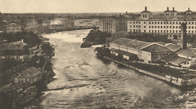
The river Narva ( et, Narva jõgi; russian: Нарва), formerly also Narova flows north into the Baltic Sea and is the largest Estonian river by discharge. A similar length of land far to the south, together with it and a much longer intermediate lake, altogether forms the Estonia-Russia border. The long lake, mentioned, which the river drains is Lake Peipus. The lake notably drains the much longer Russian river, the Velikaya, and a large, splayed drainage basin in the two countries. The river gives its name to the Narva culture and the city of Narva, which faces the Russian town Ivangorod. At the coast it passes part of the resort of Narva-Jõesuu. Its mouth is specifically into the very open WNW-facing Narva Bay of the Gulf of Finland. It gives the second-greatest discharge into the Gulf of Finland. The greatest discharge is the Neva, ranking fourth as to European rivers. Etymology The etymology of the toponym ''Narva'' is not clear, but according to the most common ... [...More Info...] [...Related Items...] OR: [Wikipedia] [Google] [Baidu] |
Hermann Castle
Hermann Castle ( et, Hermanni linnus, russian: Замок Герман; also known as Hermannsfeste, Herman Castle, Narva Castle (russian: На́рвский за́мок), and Narva fortress) is a castle in Narva, eastern Estonia. It was founded in 1256 by the Danes and the first stone castle was built in the beginning of the 14th century. The German Livonian Order purchased the castle on 29 August 1346, and owned it for much of its history. Medieval fortifications Although the exact age of Narva Castle and the town still causes arguments between historians, they agree on the following sequence of events. Initially, the Danes, who had conquered Northern Estonia (see Danish Estonia) built a wooden border stronghold at the intersection of the Narva River and an old road circa the 13th century. Under the protection of the stronghold, the earlier settlement developed into the town of Narva, which obtained the Lübeck town rights in the first half of the 14th century. Following ... [...More Info...] [...Related Items...] OR: [Wikipedia] [Google] [Baidu] |
Dendritic Drainage
In geomorphology, drainage systems, also known as river systems, are the patterns formed by the streams, rivers, and lakes in a particular drainage basin. They are governed by the topography of land, whether a particular region is dominated by hard or soft rocks, and the gradient of the land. Geomorphologists and hydrologists often view streams as part of drainage basins (and sub-basins). This is the topographic region from which a stream receives runoff, throughflow, and its saturated equivalent, groundwater flow. The number, size, and shape of the drainage basins varies and the larger and more detailed the topographic map, the more information is available. Drainage patterns Per the lie of channels, drainage systems can fall into one of several categories, known as drainage patterns. These depend on the topography and geology of the land. All forms of transitions can occur between parallel, dendritic, and trellis patterns. Accordant versus discordant drainage patterns A drai ... [...More Info...] [...Related Items...] OR: [Wikipedia] [Google] [Baidu] |
Kreenholm
Kreenholm (german: Krähnholm for ''crow islet'') is a river island in Estonia, located in the Narva River, within the city limits of Narva. The island is in area, and is long and wide. The island divides the Narva Waterfall into eastern and western branches; the Estonia–Russia border runs through the eastern branch. In the 14th century a sawmill was already operating on Kreenholm. In 1538 the Livonian Order built a watermill on the left bank of the river just opposite the island, and in 1823 a cloth factory operated by a local merchant, Paul Momma, was opened on the right bank of the Narva River. Baron Stieglitz's flax mill was located on the right bank. In 1856, Ludwig Knoop acquired the whole island and founded a textile factory there which was known as the Krenholm Manufacturing Company The Kreenholm Manufacturing Company (historical alternate spelling: Krenholm; et, Kreenholmi Manufaktuur; german: Krähnholm Manufaktur; russian: Кренгольмская ману ... [...More Info...] [...Related Items...] OR: [Wikipedia] [Google] [Baidu] |
Baltic Klint
The Baltic Klint (Clint, Glint; et, Balti klint, sv, Baltiska klinten, russian: Балтийско-Ладожский уступ, Глинт) is an erosional limestone escarpment and cuesta on several islands of the Baltic Sea, in Estonia, in Leningrad Oblast of Russia and in the islands of Gotland and Öland of Sweden. It was featured on the reverse of the 50 krooni note of 1928 and on the 100 krooni note of 1992. The Baltic Klint is active landform showing some retreat in the present. However it is not known to which degree the Baltic Klint originated in postglacial time or if it evolved from cliff-like forms sculpted by the Fennoscandian Ice Sheet. In Gotland 20th century cliff retreat rates have been estimated at 0.15 to 0.78 cm/year. Retreat of the Baltic Klint in Gotland has widened shore platforms. Geography The Baltic Klint extends approximately 1200 km from the island of Öland in Sweden through the continental shelf and the Estonian islands of Osmussaa ... [...More Info...] [...Related Items...] OR: [Wikipedia] [Google] [Baidu] |


