|
North Fremantle Railway Station
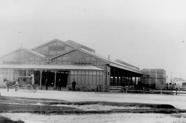
North Fremantle railway station is a railway station on the Transperth network. It is located on the Fremantle line, 16.2 kilometres from Perth, serving the Fremantle suburb of North Fremantle. History The original North Fremantle station on the north side of Tydeman Street opened in 1881. In 1964, a new station halt opened in conjunction with a new Fremantle Railway Bridge with the original site redeveloped as a diesel locomotive depot. On 28 July 1991 as part of the electrification of the line, a new station opened 800 metres to the north also replacing Leighton station that was a further 700 metres further north.Our History Public Transport Authority To the west of the station lies a freight line to the closed [...More Info...] [...Related Items...] OR: [Wikipedia] [Google] [Baidu] |
Stirling Highway
Stirling Highway is, for most of its length, a four-lane single carriageway and major arterial road between Perth, Western Australia and the port city of Fremantle in Western Australia on the northern side of the Swan River. The speed limit is . East of Crawley, it continues as Mounts Bay Road which links Crawley and the nearby University of Western Australia to the Perth central business district. The highway passes through several of Perth's western suburbs, such as Nedlands, Claremont, Peppermint Grove, Cottesloe and Mosman Park. It also passes the University of Western Australia in Crawley, and several private secondary schools - namely Christ Church Grammar School, Presbyterian Ladies' College and Methodist Ladies' College. In addition, major shopping areas exist at Claremont and Cottesloe, while many smaller businesses and retailers are dotted along the highway. The section of road from Cottesloe leading south runs alongside the railway. History Stirling Highw ... [...More Info...] [...Related Items...] OR: [Wikipedia] [Google] [Baidu] |
Fremantle Railway Station
Fremantle railway station is the terminus of Transperth's Fremantle line in Western Australia. History The original Fremantle station opened in Cliff Street on 1 March 1881 as the terminus of the Eastern Railway to Guildford via Perth. As the Eastern Railway was extended its importance grew, becoming an important hub for gold miners arriving in Western Australia via ship and then travelling to the Yilgarn and Eastern Goldfields when the line opened to Kalgoorlie in 1896. In 1907, a new station and marshalling yards were established 300 metres to the north-east on the site of the former Fremantle Railway Workshops to better service the newly constructed Fremantle Harbour. The station was designed by William Dartnall, Chief Engineer of Existing Lines of the Railway Department in 1905. The construction contract, at an estimated cost of £80,000, was awarded in May 1906 to S.B. Alexander and completed on 20 April 1907, with the official opening on 1 July 1907. Originally, ... [...More Info...] [...Related Items...] OR: [Wikipedia] [Google] [Baidu] |
Fremantle Line
The Fremantle line is a suburban railway and service in Western Australia that connects the central business district (CBD) of Perth with Fremantle. History The railway on which the service runs opened on 1 March 1881 as the first suburban railway line in Perth by William Robinson.Our History Public Transport Authority It originally operated as the Eastern Railway and ran between and |
Queen Victoria Street, Fremantle
Queen Victoria Street is the main road entering the city centre of Fremantle, Western Australia from the direction of Perth. The road was originally named Cantonment Road, but was subsequently renamed Victoria Road, and a few years later Queen Victoria Street, after Queen Victoria of the United Kingdom, to avoid confusion with similarly named roads in the area. Due to its proximity to Fremantle Harbour it has at times had very heavy traffic. Route description The road's northern terminus, as well as that of State Route 12, is at a traffic light controlled with Stirling Highway in . The next major intersection, south, is with Tydeman Road, which leads to Fremantle Port to the west, and to the residential area of North Fremantle to the east. After another , the road reaches the Fremantle Traffic Bridge which crosses the Swan River. On the south side of the river, the road meets Canning Highway, and turns south-west towards the centre of Fremantle. After travelling south- ... [...More Info...] [...Related Items...] OR: [Wikipedia] [Google] [Baidu] |
Claremont Railway Station, Perth
Claremont railway station is a railway station on the Transperth network in Western Australia. It is located on the Fremantle and Airport lines, 9.3 kilometres from Perth station serving the suburb of Claremont. History Claremont station opened in 1881 as Butlers Swamp, being renamed Claremont in 1883. In 1886 a new station was constructed 300 metres to the east. The 1886 buildings are now the oldest extant railway station buildings in Perth.History of Stations on the Fremantle Line Right Track It was the only station on the line to be built with a crossing loop. With the relocation of the |
CircleRoute
The CircleRoute is a pair of circular bus routes operated by Transperth through Perth's suburbs. History The CircleRoute was introduced in two stages. On 16 February 1998 the first stage of the CircleRoute commenced operating between Fremantle and Oats Street stations via Murdoch station. It was operated by Swan Transit with Mercedes-Benz O305 buses in a special livery with purple bands blended into the green blocks of the standard colour scheme, with an elliptical shaped logo featuring two arrows in white. On 22 February 1999, the route was extended to become a 133 stop, 84 kilometre circular route. All four Perth contractors; Path Transit, Perth Bus, Southern Coast Transit and Swan Transit, operated services. In December 2000, the services began operating daily with the introduction of a Sunday service. Prior to the CircleRoute's introduction, Perth had limited cross-suburban routes, with most of the network focused on transporting people towards the Perth central busines ... [...More Info...] [...Related Items...] OR: [Wikipedia] [Google] [Baidu] |
Fremantle Railway Station, Perth
Fremantle railway station is the terminus of Transperth's Fremantle line in Western Australia. History The original Fremantle station opened in Cliff Street on 1 March 1881 as the terminus of the Eastern Railway to Guildford via Perth. As the Eastern Railway was extended its importance grew, becoming an important hub for gold miners arriving in Western Australia via ship and then travelling to the Yilgarn and Eastern Goldfields when the line opened to Kalgoorlie in 1896. In 1907, a new station and marshalling yards were established 300 metres to the north-east on the site of the former Fremantle Railway Workshops to better service the newly constructed Fremantle Harbour. The station was designed by William Dartnall, Chief Engineer of Existing Lines of the Railway Department in 1905. The construction contract, at an estimated cost of £80,000, was awarded in May 1906 to S.B. Alexander and completed on 20 April 1907, with the official opening on 1 July 1907. Originall ... [...More Info...] [...Related Items...] OR: [Wikipedia] [Google] [Baidu] |
Midland Line, Perth
The Midland line is a suburban rail service on the Transperth network in Perth, Western Australia. It runs on the Eastern Railway through Perth's eastern suburbs and connects Midland with Perth. Travelling from Midland, the trains terminate at Fremantle on the Fremantle line. History The section of the Eastern Railway between Fremantle, Perth and Guildford was the first suburban railway line in Perth, opening on 1 March 1881. The line was extended from Guildford to Chidlow's Well, opening in March 1884. Throughout the 1880s, the Eastern Railway line was extended beyond Guildford and Midland Junction along its first route to Chidlow and Northam. The second route varied after Bellevue proceeding to Chidlow via the Swan View Tunnel, Parkerville and Stoneville. The third route saw the removal of the Bellevue Railway station in its construction, with the new Midland railway terminus replacing the older Midland Junction railway station. An anomaly of the Midland line timet ... [...More Info...] [...Related Items...] OR: [Wikipedia] [Google] [Baidu] |
Midland Railway Station, Perth
Midland railway station is the terminus of the Midland line in Perth. Western Australia. It is operated by Transperth and is connected with the feeder bus services that utilise the adjacent bus terminal in Midland. History Midland station was opened on 8 October 1968 by Minister for Transport & Railways Ray O'Connor as a replacement for Midland Junction station when the main Eastern Railway was being converted to dual gauge. It originally had four narrow gauge platform faces, three terminating and one through. A separate platform was provided for the standard gauge line 150 metres away. One of the terminating lines was lifted in the 1990s and in February 2001, the through line converted to dual gauge allowing ''The Prospector'' to call at the main station. Redevelopment In the 2010s the former Midland Redevelopment Authority (MRA) had advocated the relocation of the station east to be in line with Cale Street, the site of the original Midland Junction station. The MRA also ... [...More Info...] [...Related Items...] OR: [Wikipedia] [Google] [Baidu] |
Leighton Marshalling Yard
Leighton may refer to: Places In Australia: * Leighton, Western Australia, a beachside locality In the United Kingdom: * Leighton, Cambridgeshire *Leighton, Cheshire *Leighton, North Yorkshire **Leighton Reservoir * Leighton, Shropshire *Leighton Buzzard, a town in Bedfordshire, England *Leighton Hall, Lancashire *Leighton Hall, Powys, including Leighton Model Farm *Leighton House, Wiltshire, a country house *Leighton House Museum, a museum in London *Leighton Library, an historic library in Dunblane, Scotland *RSPB Leighton Moss, English nature reserve In the United States: *Leighton, Alabama *Leighton, Iowa *Leighton Township, Michigan In Asia: * Leighton Hill, Hong Kong People * Leighton (given name) * Leighton (surname) Other uses * CIMIC Group, Australian project development and contracting company until 2015 known as Leighton Holdings * Leighton Asia, a construction contractor headquartered in Hong Kong * Leighton Middle School, a middle school in Leighton Buzzard, E ... [...More Info...] [...Related Items...] OR: [Wikipedia] [Google] [Baidu] |
North Fremantle
North is one of the four compass points or cardinal directions. It is the opposite of south and is perpendicular to east and west. ''North'' is a noun, adjective, or adverb indicating direction or geography. Etymology The word ''north'' is related to the Old High German ''nord'', both descending from the Proto-Indo-European unit *''ner-'', meaning "left; below" as north is to left when facing the rising sun. Similarly, the other cardinal directions are also related to the sun's position. The Latin word ''borealis'' comes from the Greek '' boreas'' "north wind, north", which, according to Ovid, was personified as the wind-god Boreas, the father of Calais and Zetes. ''Septentrionalis'' is from ''septentriones'', "the seven plow oxen", a name of ''Ursa Major''. The Greek ἀρκτικός (''arktikós'') is named for the same constellation, and is the source of the English word ''Arctic''. Other languages have other derivations. For example, in Lezgian, ''kefer'' can mean b ... [...More Info...] [...Related Items...] OR: [Wikipedia] [Google] [Baidu] |
Fremantle Railway Bridge
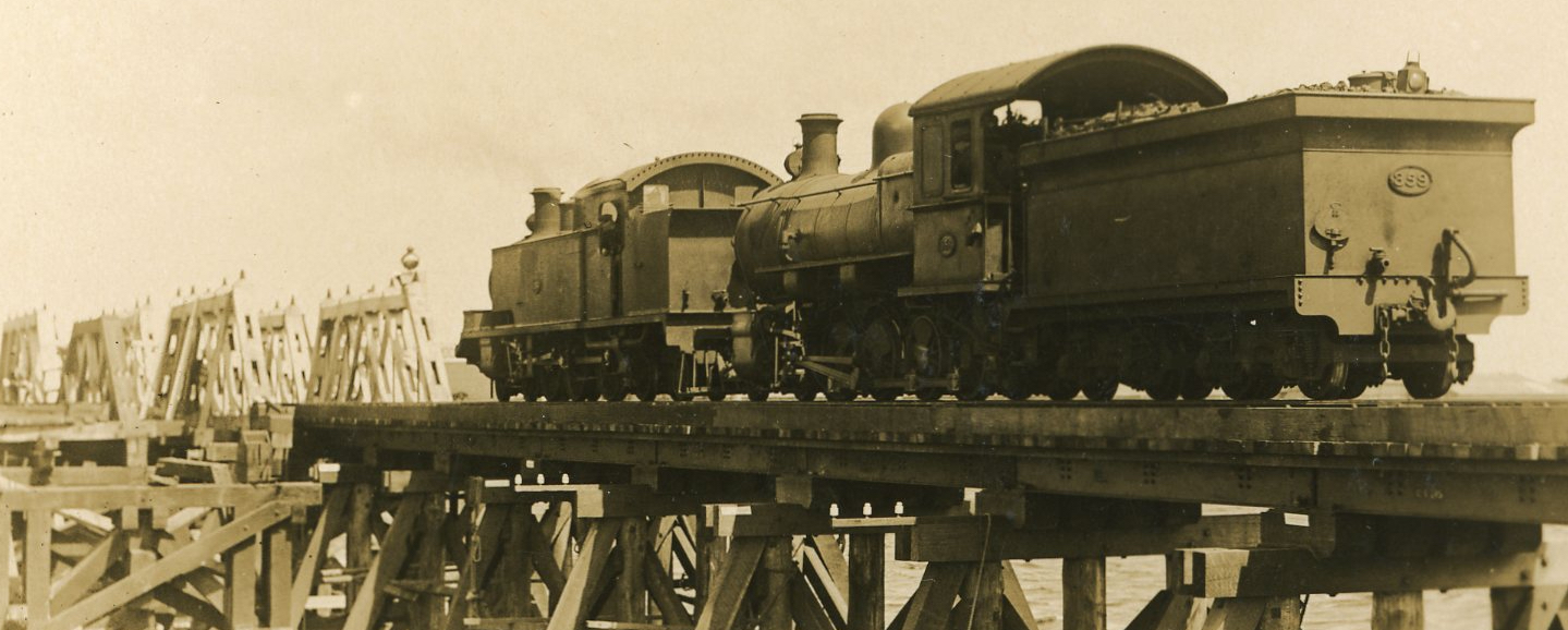
Fremantle Railway Bridge (known also as the North Fremantle Bridge) is the railway bridge on the Fremantle railway line that crosses the Swan River between Fremantle and North Fremantle. It is the second structure with that name. The original bridge was of concern due to its structure, as well as its position limiting the eastern extent of the Fremantle Harbour Fremantle Harbour is Western Australia's largest and busiest general cargo port and an important historical site. The inner harbour handles a large volume of sea containers, vehicle imports and livestock exports, cruise shipping and naval vis .... The current bridge is further up stream and closer to the Fremantle Traffic Bridge than the earlier lower structure, and was being planned in the 1950s. 1926 floods In 1926 the earlier bridge were destroyed by floods, and was re-built soon after. 2000s damage The current bridge was damaged in the 2000s by ships hitting the bridge, one during a storm, but was repa ... [...More Info...] [...Related Items...] OR: [Wikipedia] [Google] [Baidu] |


