|
New Brunswick Electoral Redistribution, 1967
The 1967 New Brunswick electoral redistribution was the first redistribution of electoral district boundaries in the New Brunswick, Canada, since 1926, and the first change in number of members since 1946. At the time, New Brunswick operated on electoral districts with fixed boundaries, and the number of members to which they were entitled varied based upon their respective population. From 1926 to 1967, each of the province's 15 counties was a district. The cities of Saint John and Moncton were districts in their own rights. These districts elected members using the bloc voting system. Under this redistribution, all six of New Brunswick's cities became electoral districts, and Saint John County was split into two districts, creating a total of 22 ridings. For the first time since 1946, this created several districts that returned only one member using the first past the post system. Electoral districts *Albert: Albert County; two members * Bathurst: City of Bathurst; ... [...More Info...] [...Related Items...] OR: [Wikipedia] [Google] [Baidu] |
Redistricting
Redistribution (re-districting in the United States and in the Philippines) is the process by which electoral districts are added, removed, or otherwise changed. Redistribution is a form of boundary delimitation that changes electoral district boundaries, usually in response to periodic census results. Redistribution is required by law or constitution at least every decade in most representative democracy systems that use first-past-the-post or similar electoral systems to prevent geographic malapportionment. The act of manipulation of electoral districts to favour a candidate or party is called gerrymandering. Australia In Australia, redistributions are carried out by independent and non-partisan commissioners in the Commonwealth, and in each state or territory. The various electoral acts require the population of each seat to be equal, within certain strictly limited variations. The longest period between two redistributions can be no greater than seven years. Many oth ... [...More Info...] [...Related Items...] OR: [Wikipedia] [Google] [Baidu] |
Campbellton (electoral District)
Campbellton-Restigouche Centre was a provincial electoral district for the Legislative Assembly of New Brunswick, Canada. The riding was created as Campbellton in the 1967 redistribution when cities were removed from county districts and is made up of the City of Campbellton and the villages of Tide Head and Atholville and their surrounding areas. It returned one member from its inception and was unchanged in the 1973 redistribution when New Brunswick moved exclusively to single member districts. The riding was again largely unchanged in the 1994 redistribution. In the 2006 redistribution it gained some geographical territory from the parts of Restigouche County Restigouche County (2016 population 30,955) is located in north-central New Brunswick, Canada. The county is named for the Restigouche River which flows through the county and is famous for its salmon pools, which have attracted wealthy American ... to its south and was renamed as a result. Members of the L ... [...More Info...] [...Related Items...] OR: [Wikipedia] [Google] [Baidu] |
Gloucester County, New Brunswick
Gloucester County (2016 population 78,444) is located in the northeastern corner of New Brunswick, Canada. Fishing, mining and forestry are the major industries in the county. The eastern section of the county is known for its Acadian culture. Census subdivisions Communities There are nineteen municipalities within the county (listed by 2016 population): First Nations There is one First Nations reservation in Gloucester County (listed with 2016 population): Parishes The county is subdivided into ten parishes (listed by 2016 population): Demographics As a census division in the 2021 Census of Population conducted by Statistics Canada Statistics Canada (StatCan; french: Statistique Canada), formed in 1971, is the agency of the Government of Canada commissioned with producing statistics to help better understand Canada, its population, resources, economy, society, and cultur ..., Gloucester County had a population of living in of its total private dwellings, a ch ... [...More Info...] [...Related Items...] OR: [Wikipedia] [Google] [Baidu] |
Gloucester (provincial Electoral District)
Gloucester was a provincial electoral district for the Legislative Assembly of New Brunswick, Canada from the 1828 election of the 9th New Brunswick Legislature. It mirrored Gloucester County, and used a bloc voting system to elect candidates. It was abolished with the 1973 electoral redistribution, divided up into five first past the post districts: Caraquet, Nepisiguit-Chaleur Nepisiguit was a provincial electoral district for the Legislative Assembly of New Brunswick A legislature is an assembly with the authority to make laws for a political entity such as a country or city. They are often contrasted with t ..., Nigadoo-Chaleur, Shippagan-les-Îles and Tracadie. Members of the Legislative Assembly Election results References {{DEFAULTSORT:Gloucester (Provincial Electoral Distric ... [...More Info...] [...Related Items...] OR: [Wikipedia] [Google] [Baidu] |
Fredericton, New Brunswick
Fredericton (; ) is the capital city of the Canadian province of New Brunswick. The city is situated in the west-central portion of the province along the Saint John River, which flows west to east as it bisects the city. The river is the dominant natural feature of the area. One of the main urban centres in New Brunswick, the city had a population of 63,116 and a metropolitan population of 108,610 in the 2021 Canadian Census. It is the third-largest city in the province after Moncton and Saint John. An important cultural, artistic, and educational centre for the province, Fredericton is home to two universities, the New Brunswick College of Craft and Design, and cultural institutions such as the Beaverbrook Art Gallery, the Fredericton Region Museum, and The Playhouse, a performing arts venue. The city hosts the annual Harvest Jazz & Blues Festival, attracting regional and international jazz, blues, rock, and world artists. Fredericton is also an important and vibrant c ... [...More Info...] [...Related Items...] OR: [Wikipedia] [Google] [Baidu] |
Fredericton (provincial Electoral District)
Fredericton was a New Brunswick electoral district. It was separated from the riding of York from 1924 until it was absorbed back into York in 1926. The riding was recreated in 1967 and existed until 1973 Events January * January 1 - The United Kingdom, the Republic of Ireland and Denmark enter the European Economic Community, which later becomes the European Union. * January 15 – Vietnam War: Citing progress in peace negotiations, U.S. ... when New Brunswick went from bloc voting to single-member ridings. Members of the Legislative Assembly Election results 1967–1973 1924–1926 Notes Former provincial electoral districts of New Brunswick 1974 disestablishments in New Brunswick {{Canada-constituency-stub ... [...More Info...] [...Related Items...] OR: [Wikipedia] [Google] [Baidu] |
Edmundston, New Brunswick
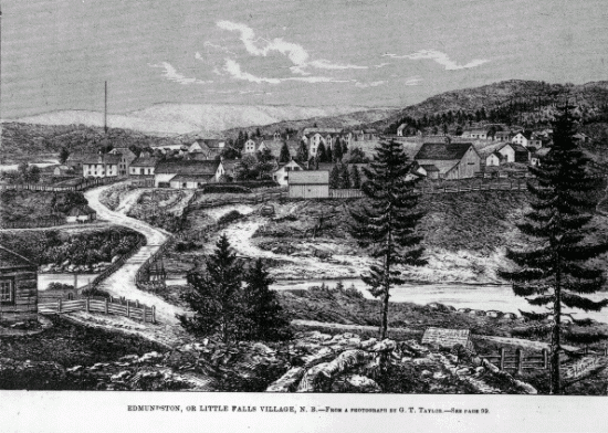
Edmundston is a city in Madawaska County, New Brunswick, Canada. On 1 January 2023, Edmundston will expanded, annexing the village of Rivière-Verte and parts of the local service districts of the parish of Saint-Jacques and the parish of Saint-Joseph. History During the early colonial period, the area was a camping and meeting place of the Maliseet (Wolastoqiyik) Nation during seasonal migrations. From the mid to late eighteenth century, one of the largest Maliseet villages had been established at Madawaska and had become a refuge site for other Wabanaki peoples. The Maliseet village was originally located near the falls at the confluence of the Madawaska and Saint John Rivers. Currently, the City of Edmundston surrounds a federal Indian Reserve (St. Basile 10/Madawaska Maliseet First Nation). Originally named ''Petit-Sault'' (Little Falls) in reference to the waterfalls located where the Madawaska River merges into the Saint John River, the settlement was renamed ''Edmu ... [...More Info...] [...Related Items...] OR: [Wikipedia] [Google] [Baidu] |
Edmundston (electoral District)
Edmundston was a provincial electoral district for the Legislative Assembly of New Brunswick, Canada Canada is a country in North America. Its ten provinces and three territories extend from the Atlantic Ocean to the Pacific Ocean and northward into the Arctic Ocean, covering over , making it the world's second-largest country by tot .... It was superseded by the Edmundston-Saint Basile district in 2006. Members of the Legislative Assembly Election results External linksWebsite of the Legislative Assembly of New Brunswick Former provincial electoral districts of New Brunswick {{Canada-constituency-stub ... [...More Info...] [...Related Items...] OR: [Wikipedia] [Google] [Baidu] |
Charlotte County, New Brunswick
Charlotte County (2016 population 25,428) is the southwest-most List of counties of New Brunswick, county of New Brunswick, Canada. It was formed in 1784 when New Brunswick was partitioned from Nova Scotia. Once a layer of local government, the county seat was abolished with the New Brunswick Equal Opportunity program in 1966. Counties continue to be used as census subdivision, census sundivisions by Statistics Canada. Located in the southwestern corner of the province, bordering the US state of Maine, Charlotte County is at the northern end of the Appalachian Mountains, which gives it a rugged terrain that includes Mount Pleasant Caldera, Mount Pleasant. The St. Croix River (Maine–New Brunswick), St. Croix, Magaguadavic River, Magaguadavic, and Digdeguash, New Brunswick, Digdegaush rivers drain into the Bay of Fundy. The county includes the large, populated islands of Grand Manan, White Head Island, White Head, Deer Island (New Brunswick), Deer Island, and Campobello Island, ... [...More Info...] [...Related Items...] OR: [Wikipedia] [Google] [Baidu] |
Charlotte (provincial Electoral District)
Charlotte ( ) is the most populous city in the U.S. state of North Carolina. Located in the Piedmont region, it is the county seat of Mecklenburg County. The population was 874,579 at the 2020 census, making Charlotte the 16th-most populous city in the U.S., the seventh most populous city in the South, and the second most populous city in the Southeast behind Jacksonville, Florida. The city is the cultural, economic, and transportation center of the Charlotte metropolitan area, whose 2020 population of 2,660,329 ranked 22nd in the U.S. Metrolina is part of a sixteen-county market region or combined statistical area with a 2020 census-estimated population of 2,846,550. Between 2004 and 2014, Charlotte was ranked as the country's fastest-growing metro area, with 888,000 new residents. Based on U.S. Census data from 2005 to 2015, Charlotte tops the U.S. in millennial population growth. It is the third-fastest-growing major city in the United States. Residents are referred ... [...More Info...] [...Related Items...] OR: [Wikipedia] [Google] [Baidu] |
Carleton County, New Brunswick
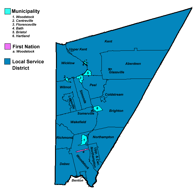
Carleton County (2016 population 26,220) is located in west-central New Brunswick, Canada. The western border is Aroostook County, Maine, Aroostook County, Maine, the northern border is Victoria County, New Brunswick, Victoria County, and the southeastern border is York County, New Brunswick, York County from which it was formed in 1831. The Saint John River (New Brunswick), Saint John River bisects the western section of the county. The Southwest Miramichi River flows through the eastern section of the county. Potato farming is a major industry. The scenic town of Hartland, New Brunswick, Hartland is home to the longest covered bridge in the world. Transportation Major Highways * * * * * * * * * * * * * * * * * * * * Census subdivisions List of communities in New Brunswick, Communities There are five incorporated municipalities within Carleton County (listed by 2016 population): First Nations There is one First Nations reserve in Carleton County, the Woodstock_First_Na ... [...More Info...] [...Related Items...] OR: [Wikipedia] [Google] [Baidu] |
Carleton (New Brunswick Provincial Electoral District)
Carleton is a provincial electoral district for the Legislative Assembly of New Brunswick, Canada. It is located in the west-central part of the province, and is centred on the towns of Woodstock and Hartland. It was first contested in the 2014 general election, having been created in the 2013 redistribution of electoral boundaries from portions of the former ridings of Woodstock, Carleton and a small part of York North. The district includes the south-central parts of Carleton County Carleton County (2016 population 26,220) is located in west-central New Brunswick, Canada. The western border is Aroostook County, Maine, the northern border is Victoria County, and the southeastern border is York County from which it was fo .... Members of the Legislative Assembly Election results External links Website of the Legislative Assembly of New Brunswick [...More Info...] [...Related Items...] OR: [Wikipedia] [Google] [Baidu] |


