|
National Freeway 6
National freeway 6, also known as Shuishalian Freeway or Central East-West Freeway, is a freeway between Wufeng, Taichung and Puli, Nantou, and all of the main line was already open to traffic on 21 March 2009. The freeway runs parallel with provincial highway 14 for most of its length. Length The length is about 37.6 km between Wufeng, Taichung and Puli, Nantou. Exit List Background Its construction began on 25 March 2004. On 27 January 2008, the main line between Ailan IC and Puli terminal was open to traffic. Then, the main line between Wufeng JCT and East Caotun IC, and the East Caotun connection way were open to traffic on 27 December 2008. The other part of main line between east Caotun IC and Ailan IC was already open to traffic on 21 March 2009. Afterwards, Guoxing IC was open to traffic on 22 October 2009. Then, Jiuzheng IC was open to traffic on 31 January 2011. Beishan IC was completed on 21 November 2013. There is a plan to extend the r ... [...More Info...] [...Related Items...] OR: [Wikipedia] [Google] [Baidu] |
Wufeng District
Wufeng District () is a suburban district in southern Taichung, Taiwan. It is the location of Taiwan Provincial Consultative Council. Wufeng is a mainly agricultural town. It was heavily damaged by the Jiji earthquake on 21 September 1999, which caused around 100 deaths in the town. The 921 Earthquake Museum of Taiwan, which commemorates the giant quake, is built at what was formerly Guangfu Junior High School, which was destroyed when part of the school was uplifted by the Chelungpu Fault during the quake. The two major geographical features of this town are the Wu Xi (Wu Stream), which forms the town's southern border, and Xiangbi Shan (Elephant Trunk Mountain), which lies in the eastern part of the township. History Formerly called ''Atabu'' (). Administrative divisions Tonglin, Jifeng, Jiayin, Benxiang, Zhongzheng, Jinrong, Laiyuan, Bentang, Beiliu, Nanliu, Side, Wufu, Dingtai, Beishi, Nanshi, Wanfeng, Jiuzheng, Kengkou, Fenggu Liugu Village. Geography * Area: 98.0 ... [...More Info...] [...Related Items...] OR: [Wikipedia] [Google] [Baidu] |
Puli, Nantou
Puli Township () is an urban township in Nantou County, Taiwan. The township is located within the Puli Basin. It is the geographic center of Taiwan. Name In the 19th century the city was known as Posia () or Po-li-sia (). The Atayal name of the settlement was Sabaha Bakalas, meaning "house of stars". From 1920, during the Japanese era, the town was administered as , , Taichū Prefecture. History Spread of Christianity In 1870, a native of Po-li-sia named Khai-san received treatment for a medical issue in a missionary hospital in Taiwan-fu (present-day Tainan) and learned about Christianity. When he returned home, he spread information about Christianity to the people of the area. In July 1871, two native preachers were sent to the area after reports concerning the spread of Christianity in Po-li-sia were heard of in Taiwan-fu. They reported back that "a movement, favourable to Christianity, had really taken place" in the area. Members of the Canada Presbyterian Mission vi ... [...More Info...] [...Related Items...] OR: [Wikipedia] [Google] [Baidu] |
West End Of The Taiwan No6 National Highway At Wufeng JCT
West or Occident is one of the four cardinal directions or points of the compass. It is the opposite direction from east and is the direction in which the Sun sets on the Earth. Etymology The word "west" is a Germanic word passed into some Romance languages (''ouest'' in French, ''oest'' in Catalan, ''ovest'' in Italian, ''oeste'' in Spanish and Portuguese). As in other languages, the word formation stems from the fact that west is the direction of the setting sun in the evening: 'west' derives from the Indo-European root ''*wes'' reduced from ''*wes-pero'' 'evening, night', cognate with Ancient Greek ἕσπερος hesperos 'evening; evening star; western' and Latin vesper 'evening; west'. Examples of the same formation in other languages include Latin occidens 'west' from occidō 'to go down, to set' and Hebrew מַעֲרָב maarav 'west' from עֶרֶב erev 'evening'. Navigation To go west using a compass for navigation (in a place where magnetic north is the same dir ... [...More Info...] [...Related Items...] OR: [Wikipedia] [Google] [Baidu] |
Freeway
A controlled-access highway is a type of highway that has been designed for high-speed vehicular traffic, with all traffic flow—ingress and egress—regulated. Common English terms are freeway, motorway and expressway. Other similar terms include '' throughway'' and '' parkway''. Some of these may be limited-access highways, although this term can also refer to a class of highways with somewhat less isolation from other traffic. In countries following the Vienna convention, the motorway qualification implies that walking and parking are forbidden. A fully controlled-access highway provides an unhindered flow of traffic, with no traffic signals, intersections or property access. They are free of any at-grade crossings with other roads, railways, or pedestrian paths, which are instead carried by overpasses and underpasses. Entrances and exits to the highway are provided at interchanges by slip roads (ramps), which allow for speed changes between the highway and arter ... [...More Info...] [...Related Items...] OR: [Wikipedia] [Google] [Baidu] |
Wufeng, Taichung
Wufeng District () is a suburban district in southern Taichung, Taiwan. It is the location of Taiwan Provincial Consultative Council. Wufeng is a mainly agricultural town. It was heavily damaged by the Jiji earthquake on 21 September 1999, which caused around 100 deaths in the town. The 921 Earthquake Museum of Taiwan, which commemorates the giant quake, is built at what was formerly Guangfu Junior High School, which was destroyed when part of the school was uplifted by the Chelungpu Fault during the quake. The two major geographical features of this town are the Wu Xi (Wu Stream), which forms the town's southern border, and Xiangbi Shan (Elephant Trunk Mountain), which lies in the eastern part of the township. History Formerly called ''Atabu'' (). Administrative divisions Tonglin, Jifeng, Jiayin, Benxiang, Zhongzheng, Jinrong, Laiyuan, Bentang, Beiliu, Nanliu, Side, Wufu, Dingtai, Beishi, Nanshi, Wanfeng, Jiuzheng, Kengkou, Fenggu Liugu Village. Geography * Area: 98. ... [...More Info...] [...Related Items...] OR: [Wikipedia] [Google] [Baidu] |
Taiwan Area National Freeway Bureau
The Freeway Bureau () is the government agency under the Ministry of Transportation and Communications of the Taiwan (ROC) in charge for freeway-related matters. History The bureau was originally established on 8 June 1970 as Freeway Engineering Bureau. On 1 December 1978, it was renamed to Taiwan Area National Freeway Bureau. On 12 February 2018, Taiwan Area National Freeway Bureau merged with Taiwan Area National Expressway Engineering Bureau, and was renamed the Freeway Bureau. Organizational structure * Civil Service Ethics Office * Personnel Office * BAS Office * Secretary Office * Land Division * Construction Division * Technical Division * Toll and Service Division * Traffic Management Division * Widening Region Engineering Office * Southern Region Engineering Office * Central Region Engineering Office * Northern Region Engineering Office See also * Ministry of Transportation and Communications (Taiwan) The Ministry of Transportation and Communications (MOTC; ) is a c ... [...More Info...] [...Related Items...] OR: [Wikipedia] [Google] [Baidu] |
Taichung City
Taichung (, Wade–Giles: ''Tʻai²-chung¹'', pinyin: ''Táizhōng''), officially Taichung City, is a special municipality located in central Taiwan. Taichung has approximately 2.8 million residents and is the second most populous city of Taiwan, as well as the most populous city in Central Taiwan. It serves as the core of the Taichung–Changhua metropolitan area, the second largest metropolitan area in Taiwan. Located in the Taichung Basin, the city was initially developed from several scattered hamlets helmed by the Taiwanese indigenous peoples. It was constructed to be the new capital of Taiwan Province and renamed as " Taiwan-fu" in the late Qing dynastic era between 1887 and 1894. During the Japanese era from 1895, the urban planning of present-day city of Taichung was performed and developed by the Japanese. From the start of ROC rule in 1945, the urban area of Taichung was organized as a provincial city up until 25 December 2010, when the original provincial city and ... [...More Info...] [...Related Items...] OR: [Wikipedia] [Google] [Baidu] |
Caotun, Nantou
Caotun Township, formerly transliterated as Tsaotun Township, is an urban township in the northwest of Nantou County, Taiwan. It is the largest township in Taiwan by population. History The area was historically known as ''Chháu-ê-tun'' () with the present name adopted under Japanese rule in 1920. Administrative divisions The township comprises 27 villages: Beishi, Beitou, Bifeng, Bizhou, Duihe, Fuliao, Fuxing, Heping, Jialao, Mingzheng, Nanpu, Pingding, Pinglin, Shanglin, Shanjiao, Shichuan, Shuangdong, Tucheng, Xincuo, Xinfeng, Xinzhuang, Yanfeng, Yufeng, Yushi, Zhongshan, Zhongyuan and Zhongzheng. Education * Nan Kai University of Technology Tourist attractions * Caotun Night Market * Jiujiufeng * Taiwan Times Village * Yu-hsiu Museum of Art Transportation The nearest train station to Caotun is the Yuanlin Station of the Taiwan Railway Administration in Changhua County. Taichung City Bus route 108 have reach Nan Kai University of Technology, however 10km+10 TWD prom ... [...More Info...] [...Related Items...] OR: [Wikipedia] [Google] [Baidu] |
Nantou County
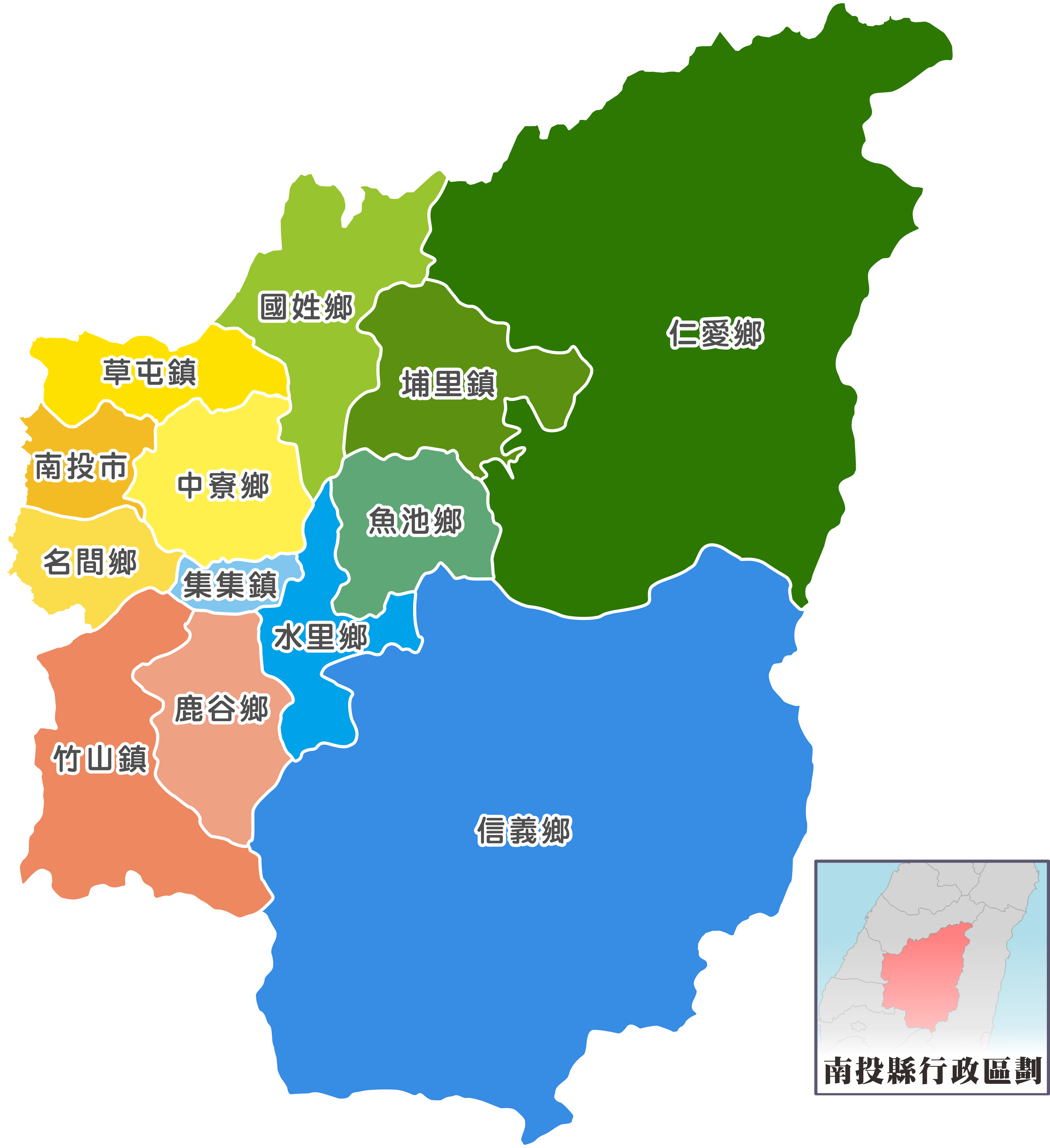
Nantou County (; Hokkien POJ: ''Lâm-tâu-koān''; Hakka PFS: ''Nàm-thèu-yen'') is the second largest county of Taiwan by area, located in the central part of the country. It is also the only non-coastal county in Taiwan. Its name derives from the Hoanya Taiwanese aboriginal word ''Ramtau''. Its mountainous area makes it a tourist destination; Sun Moon Lake is located in this county. Other well-known sightseeing of the county including Aowanda, Formosan Aboriginal Culture Village, Hehuanshan, Paper Dome, Qingjing Farm, Shanlinxi, Shuiyuan Suspension Bridge and Xitou. Notable cities in Nantou are Nantou City and Puli Town. The official butterfly of Nantou County is the broad-tailed swallowtail butterfly (''Agehana maraho''). Nantou's tung-ting tea is one of the most famous and high-quality oolong teas grown in Taiwan. History Early history Before the arrival of Han Chinese to Nantou, the Atayal, Bunun and Tsou tribes were distributed throughout the northern and ce ... [...More Info...] [...Related Items...] OR: [Wikipedia] [Google] [Baidu] |
Guoxing, Nantou
Guoxing Township () is a rural township in Nantou County, Taiwan. As of January 2014, the township has a population total of 19,715. Administrative divisions Guoxing, Shimen, Daqi, Zhangliu, Zhangfeng, Zhangfu, Beigang, Fugui, Gangou, Ganlin, Dashi, Beishan and Nangang Villages. Tourist attractions * Nuomi Bridge Notable natives * Peng Pai-hsien, Magistrate of Nantou County (2001) Transportation Guoxing Interchange connects Guoxing Township to National freeway 6 National freeway 6, also known as Shuishalian Freeway or Central East-West Freeway, is a freeway between Wufeng, Taichung and Puli, Nantou, and all of the main line was already open to traffic on 21 March 2009. The freeway runs parallel with .... Guoxing Township is served by Nantou Bus, Taichung Bus, and Chuan Hang Bus. External links Guoshing Township Office Townships in Nantou County {{Taiwan-geo-stub ... [...More Info...] [...Related Items...] OR: [Wikipedia] [Google] [Baidu] |
Yuchi, Nantou
Yuchi Township (, also known as Yuchih) is a rural township in the center of Nantou County, Taiwan. History The area is home to the Thao people who live near Sun Moon Lake. The township was formerly called ''Go-sia-po'' () Administrative divisions The township comprises 13 villages: Dalin, Dayan, Gonghe, Riyue, Shuishe, Toushe, Tungchi, Tungguang, Wucheng, Wudeng, Xincheng, Yuchi and Zhongming. Tourist attractions * Ci En Pagoda * Dajhu Lake Waterbirds Reserve * Formosan Aboriginal Culture Village * Jinlong Mountain * Kong-ming Temple * Lalu Island * Peacock Park * Shuei-she Mountain * Sun Moon Lake * Wen Wu Temple * Tataka Visitor Center * Xuanzang Temple Transportation * Provincial Highway No. 21 goes through Yuchi. * Sun Moon Lake Ropeway * Shuishe Pier Notable natives * Lin Yang-kang, President of Judicial Yuan (1987–1994) * Tang Huo-shen, member of Legislative Yuan The Legislative Yuan is the unicameral legislature of the Republic of China (Taiwan) loca ... [...More Info...] [...Related Items...] OR: [Wikipedia] [Google] [Baidu] |


