|
Mymensingh Division
Mymensingh Division ( bn, ময়মনসিংহ বিভাগ) is one of the eight administrative divisions of Bangladesh. It has an area of and a population of 11,370,000 as of the 2011 census. It was created in 2015 from districts previously composing the northern part of Dhaka Division. Its headquarters are in Mymensingh city in Mymensingh District. History The Greater Mymensingh region (Mymensingh District along with five other neighbouring districts) was created as a Mymensingh district by the British Indian government in 1787. Later it was reorganized in two phases into six districts: Mymensingh, Kishoreganj, Netrakona, Jamalpur, Tangail, and Sherpur. But Kishoreganj and Tangail are no longer part of Mymensingh, so Mymensingh comprises four districts. On 12 January 2015 prime minister Sheikh Hasina declared the establishment of a new Mymensingh Division. The initial intention was to carve six districts (those comprising the original Mymensingh district of 1787 ... [...More Info...] [...Related Items...] OR: [Wikipedia] [Google] [Baidu] |
Jamalpur Sadar Upazila
Jamalpur Sadar ( bn, জামালপুর সদর) is an upazila of Jamalpur District in the Division of Mymensingh, Bangladesh. Geography Jamalpur Sadar is located at . It has 102,578 households and a total area of 489.56 km2. Demographics According to the 1991 Bangladesh census, Jamalpur Sadar had a population of 501,924, of whom 263,338 were aged 18 or over. Males constituted 51.47% of the population, and females 48.53%. Jamalpur Sadar had an average literacy rate of 27.6% (7+ years), against the national average of 32.4% . Administration Jamalpur Sadar Upazila is divided into Jamalpur Municipality and 15 union parishads: Banshchara, Digpaith, Ghoradhap, Itail, Kendua, Lakshmir Char, Meshta, Narundi, Ranagachha, Rashidpur, Sahabajpur, Sharifpur, Sreepur, Titpalla, and Tulsir Char. The union parishads are subdivided into 250 mauzas and 365 villages. Upazila Nirbahi Officer (UNO): Mohammad Abdul Salam See also *Upazilas of Bangladesh An ''upazila'' ( bn, � ... [...More Info...] [...Related Items...] OR: [Wikipedia] [Google] [Baidu] |
Rangpur Division
Rangpur Division ( bn, রংপুর বিভাগ) is one of the Divisions in Bangladesh. It was formed on 25 January 2010, as Bangladesh's 7th division. Before that, it was under Rajshahi Division. The Rangpur division consists of eight districts. There are 58 Upazilas or subdistricts under these eight districts. Rangpur is the northernmost division of Bangladesh and has a population of 15,665,000 in the 2011 Census. The major cities of this new division are Rangpur, Saidpur and Dinajpur. Rangpur has well-known educational institutions, such as Carmichael College, Hajee Mohammad Danesh Science and Technology University, Rangpur Medical College, Rangpur Cadet College, Begum Rokeya University and Bangladesh Army University of Science and Technology, Saidpur. Mansingh, commander of Emperor Akbar, conquered part of Rangpur in 1575. Rangpur came completely under the Mughal empire in 1686. Mughalbasa and Mughalhat of Kurigram district still bear marks of the Mughal rule in ... [...More Info...] [...Related Items...] OR: [Wikipedia] [Google] [Baidu] |
Rajshahi Division
Rajshahi Division ( bn, রাজশাহী বিভাগ) is one of the eight first-level administrative divisions of Bangladesh. It has an area of and a population at the 2011 Census of 18,484,858. Rajshahi Division consists of 8 districts, 70 Upazilas (the next lower administrative tier) and 1,092 Unions (the lowest administrative tier). The region has historically been dominated by various feudal Rajas, Maharajas and Zamindars. Formerly comprising 16 districts, a new division (Rangpur Division) was formed with the 8 northern districts of the old Rajshahi Division from early 2010. Etymology and names The Rajshahi Division is named after Rajshahi District. Dominated by various feudal Rajas, Maharajas and Zamindars of mixed origins throughout history, the name is a compound of the words ''Raj'' and ''Shahi'', both of which can be translated into reign or kingdom. Archaic spellings in the English language also included ''Rajeshae''. The capital city of the division was for ... [...More Info...] [...Related Items...] OR: [Wikipedia] [Google] [Baidu] |
Comilla Division
Meghna Division (Bengali: মেঘনা বিভাগ) is a proposed administrative division within Bangladesh for the north-western parts of the existing Chittagong Division, comprising Brahmanbaria, Comilla, Chandpur, Noakhali, Feni, and Laxmipur Districts of Chittagong Division. The headquarter of the division is in Comilla. It covers the south-easternmost areas of the country, with a total area of and a population at the 2011 census of 16,708,000. Terminology and naming dispute Various terms are used to describe the different (and sometimes overlapping) geographical and political areas of the proposed Meghna division. In brief, the main terms and their simple explanations are as follows: * Geographical terms: * Samatata (or Samatat) ( bn, links=no, সমতট); was an ancient kingdom. Cumilla region and greater Nokhali region were within The Kingdom of Samatata.Geographically, the proposed Division is made up of two distinct cultural regions – Cumilla and Greater ... [...More Info...] [...Related Items...] OR: [Wikipedia] [Google] [Baidu] |
Sylhet Division
Sylhet Division ( bn, সিলেট বিভাগ) is the northeastern division of Bangladesh. It is bordered by the Indian states of Meghalaya, Assam and Tripura to the north, east and south respectively, and by the Bangladeshi divisions of Chittagong to the southwest and Dhaka and Mymensingh to the west. Prior to 1947, it included the subdivision of Karimganj (presently in Barak Valley, India). However, Karimganj (including the thanas of Badarpur, Patharkandi and Ratabari) was inexplicably severed from Sylhet by the Radcliffe Boundary Commission. According to Niharranjan Ray, it was partly due to a plea from a delegation led by Abdul Matlib Mazumdar. Etymology and names The name ''Sylhet'' is an anglicisation of ''Shilhot'' (শিলহট). Its origins seem to come from the Sanskrit words শিলা ''śilā'' (meaning 'stone') and হট্ট ''haṭṭa'' (meaning 'marketplace'). These words match the landscape and topography of the hilly region. The shila stones ... [...More Info...] [...Related Items...] OR: [Wikipedia] [Google] [Baidu] |
India
India, officially the Republic of India (Hindi: ), is a country in South Asia. It is the seventh-largest country by area, the second-most populous country, and the most populous democracy in the world. Bounded by the Indian Ocean on the south, the Arabian Sea on the southwest, and the Bay of Bengal on the southeast, it shares land borders with Pakistan to the west; China, Nepal, and Bhutan to the north; and Bangladesh and Myanmar to the east. In the Indian Ocean, India is in the vicinity of Sri Lanka and the Maldives; its Andaman and Nicobar Islands share a maritime border with Thailand, Myanmar, and Indonesia. Modern humans arrived on the Indian subcontinent from Africa no later than 55,000 years ago., "Y-Chromosome and Mt-DNA data support the colonization of South Asia by modern humans originating in Africa. ... Coalescence dates for most non-European populations average to between 73–55 ka.", "Modern human beings—''Homo sapiens''—originated in Africa. Then, int ... [...More Info...] [...Related Items...] OR: [Wikipedia] [Google] [Baidu] |
Meghalaya
Meghalaya (, or , meaning "abode of clouds"; from Sanskrit , "cloud" + , "abode") is a states and union territories of India, state in northeastern India. Meghalaya was formed on 21 January 1972 by carving out two districts from the state of Assam: (a) the United Khasi Hills and Jaintia Hills and (b) the Garo Hills.History of Meghalaya State Government of India Meghalaya was previously part of Assam, but on 21 January 1972, the districts of Khasi, Garo and Jaintia Hills became the new state of Meghalaya. The population of Meghalaya as of 2014 is estimated to be 3,211,474. Meghalaya covers an area of approximately 22,430 square kilometres, with a length-to-breadth ratio of about 3:1.Meghal ... [...More Info...] [...Related Items...] OR: [Wikipedia] [Google] [Baidu] |
Christianity In Bangladesh
Christians in Bangladesh account for 0.30% (roughly 500,000 believers) of the nation's population as of 2022 census. Together with Judaism and Buddhism (plus other minority religious groups such as Atheism, Sikhism, the Bahá’í Faith and others), they account for 1% of the population. Islam accounts for 91.04% of the country's religion, followed by Hinduism at 7.95% as per 2022 census. History The introduction and development of Christianity in the Indian Subcontinent can be traced back to several different periods, with the help of several different countries and denominations. The earliest connection to Christianity can be linked back to the arrival of the Apostle Thomas to the Malabar Coast during the first century, in 52 A.D. In addition, the Apostle had managed to convert several thousands of Hindu Brahmins, as they were "attracted" to the lifestyle and were "impressed" by Jesus' sacrifice. Christianity did not have a presence in Bangladesh until the arrival of t ... [...More Info...] [...Related Items...] OR: [Wikipedia] [Google] [Baidu] |
Hinduism In Bangladesh
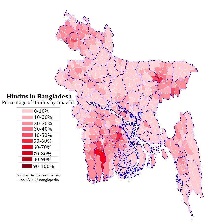
Hinduism is the second largest religious affiliation in People's Republic of Bangladesh, as according to the Official 2022 Census of Bangladesh, approximately just 13.1 million people responded that they were Hindus, constituting 7.95% out of the total population of 165.15 million people. In terms of population, Bangladesh is the third-largest Hindu populated country of the world, just after India and Nepal. Hinduism is the second-largest religion in 61 out of 64 districts of Bangladesh, but there is no Hindu majority district in Bangladesh. Culture In nature, Bangladeshi Hinduism closely resembles the forms and customs of Hinduism practiced in the neighboring Indian state of West Bengal, with which Bangladesh (at one time known as East Bengal) was united until the partition of India in 1947. The vast majority of Hindus in Bangladesh are Bengali Hindus. Goddess ( Devi) – usually venerated as Durga or Kali – is widely revered, often alongside her consort Shiva. The w ... [...More Info...] [...Related Items...] OR: [Wikipedia] [Google] [Baidu] |
Islam In Bangladesh
Islam is the state religion of the People's Republic of Bangladesh. According to the 2022 census, Bangladesh had a population of about 150 million Muslims, or 91.04% of its total population of million. The majority of Bangladeshis are Sunni, and follow the Hanafi school of fiqh. Religion is an integral part of Bangladeshi identity. Despite being a Muslim-majority country, Bangladesh is a ''de facto'' secular state. In the 9th century, Arab Muslims established commercial as well as religious connection within the region before the conquest, mainly through the coastal regions as traders and primarily via the ports of Chittagong. Region was largely inhabited by different animistic tribes. Arab navigation in the region was the result of the Muslim reign over the Indus delta. In the early 13th century, Muhammad bin Bakhtiyar Khalji conquered Western and part of Northern Bengal, and established the first Muslim kingdom in Bengal. Islamic missionaries in India achieved their greatest ... [...More Info...] [...Related Items...] OR: [Wikipedia] [Google] [Baidu] |
Sherpur Sadar Upazila
Sherpur Sadar ( bn, শেরপুর সদর) is an upazila of Sherpur District in the Division of Mymensingh, Bangladesh. Demographics As of the 1991 Bangladesh census, Sherpur Sadar has a population of 381,419. Males constitute 51.58% of the population, and females 48.42%. This Upazila's eighteen up population is 189,019. Sherpur Sadar has an average literacy rate of 78.23% (7+ years), and the national average of 32.4% literate. Administration Sherpur Sadar Upazila is divided into Sherpur Municipality and 14 union parishads: Bajitkhila, Balairchar, Betmari Ghughurakandi, Chormochoriya, Chorpokhimari, Chorsherpur, Dhola, Gajirkhamar, Kamarar Chor, Kamariya, Losmonpur, Pakuriya, Rouha, and Vatshala. The union parishads are subdivided into 100 mauzas and 188 villages. Sherpur Municipality is subdivided into 9 wards and 46 mahallas. Education There are 11 colleges in the upazila: Sherpur Government College., Sherpur Government Mohila College, Beer Muktijodda Atiur Rahman ... [...More Info...] [...Related Items...] OR: [Wikipedia] [Google] [Baidu] |


