|
Murphy Dome AFS
Murphy Dome Air Force Station (AAC ID: F-02, LRR ID: A-02) is a closed United States Air Force General Surveillance Radar station west-northwest of Fairbanks, Alaska. The control center station was closed on 1 November 1983, and was re-designated as a Long Range Radar (LRR) site as part of the Alaska Radar System. Today, it remains active as part of the Alaska NORAD Region under the jurisdiction of the Pacific Air Forces Regional Support Center, Joint Base Elmendorf–Richardson, Alaska. History Murphy Dome AFS was a continental defense radar station constructed to provide the United States Air Force early warning of an attack by the Soviet Union on Alaska. It was one of the ten original aircraft control and warning sites constructed during the early 1950s to establish a permanent air defense system in Alaska. Murphy Dome was initially operated by a detachment of the 532nd Aircraft Control and Warning Group, Ladd AFB (now Fort Wainwright). The station functioned as a Ground-C ... [...More Info...] [...Related Items...] OR: [Wikipedia] [Google] [Baidu] |
Alaskan Air Command
Alaskan Air Command (AAC) is an inactive United States Air Force Major Command originally established in 1942 under the United States Army Air Forces. Its mission was to organize and administer the air defense system of Alaska, exercise direct control of all active measures, and coordinate all passive means of air defense. In addition, the command also supported Strategic Air Command elements operating through and around Alaska. It was redesignated Eleventh Air Force on 9 August 1990 and, concurrently, status changed from a major command of the United States Air Force to a subordinate organization of Pacific Air Forces. History Establishment Established on 18 December 1945 the end of World War II, assuming jurisdiction of former Eleventh Air Force, assets in the Alaska Territory. Headquartered at Davis Army Airfield on Adak, the initial mission of AAC was the consolidation of wartime Army Air Forces in Alaska and training of those forces remaining after demobilization. Its ... [...More Info...] [...Related Items...] OR: [Wikipedia] [Google] [Baidu] |
AN/FPS-117
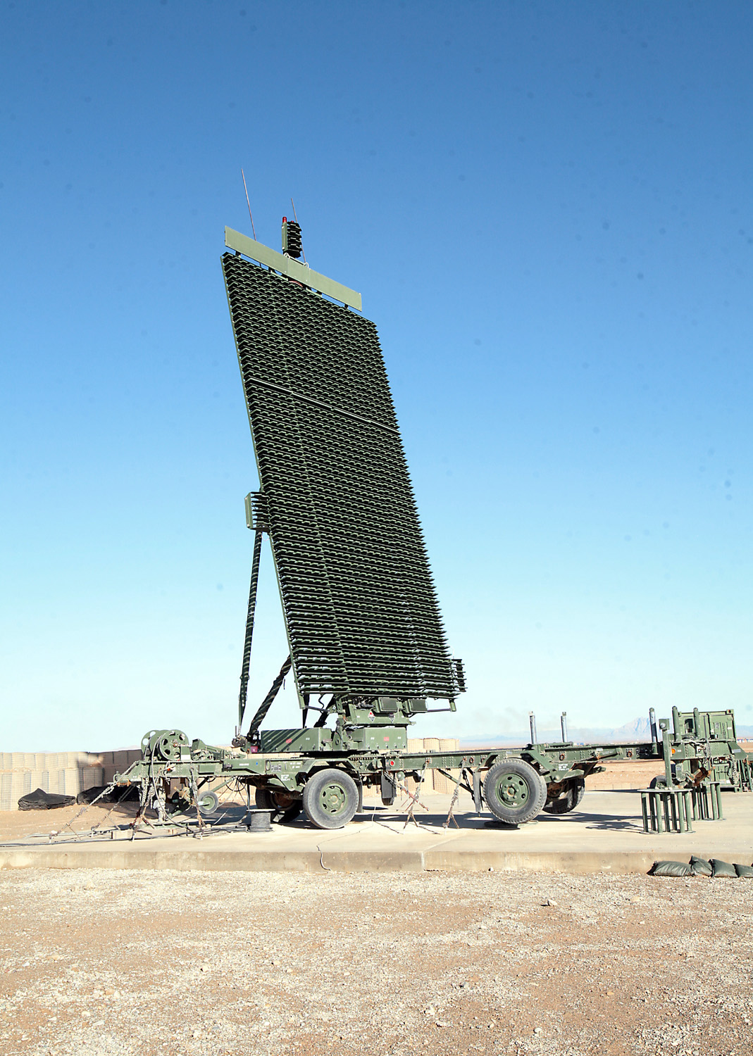
The AN/FPS-117 is an L-band active electronically scanned array (AESA) 3-dimensional air search radar first produced by GE Aerospace in 1980 and now part of Lockheed Martin. The system offers instrumented detection at ranges on the order of and has a wide variety of interference and clutter rejection systems. The system was originally developed as part of the "Seek Igloo/Seek Frost" effort to replace the older radar systems of the DEW line with designs that could be operated remotely and require much less maintenance as part of DEW's replacement, the American-Canadian North Warning System (NWS). Implementation of the NWS resulted in a reduction in operations and maintenance spending by up to 50% compared to previous systems. GE made a number of modifications to the basic design to better tailor it to different roles. To fill a need for the US Marine Corps, GE developed the transportable AN/TPS-59, and later combined design elements to produce the smaller AN/TPS-77 which is even m ... [...More Info...] [...Related Items...] OR: [Wikipedia] [Google] [Baidu] |
Fairbanks Defense Area
The following is a list of Nike missile sites operated by the United States Army. This article lists sites in the United States, most responsible to Army Air Defense Command; however, the Army also deployed Nike missiles to Europe as part of the NATO alliance, with sites being operated by both American and European military forces. U.S. Army Nike sites were also operational in South Korea, Japan and were sold to Taiwan. Leftover traces of the approximately 265 Nike missile bases can still be seen around cities across the United States. As the sites were decommissioned, they were first offered to federal agencies. Many were already on Army National Guard bases who continued to use the property. Others were offered to state and local governments, while others were sold to school districts. The leftovers were offered to private individuals. Many Nike sites are now municipal yards, communications, and FAA facilities, probation camps, and even renovated for use as airsoft gaming and ... [...More Info...] [...Related Items...] OR: [Wikipedia] [Google] [Baidu] |
United States Army
The United States Army (USA) is the land service branch of the United States Armed Forces. It is one of the eight U.S. uniformed services, and is designated as the Army of the United States in the U.S. Constitution.Article II, section 2, clause 1 of the United States Constitution (1789). See alsTitle 10, Subtitle B, Chapter 301, Section 3001 The oldest and most senior branch of the U.S. military in order of precedence, the modern U.S. Army has its roots in the Continental Army, which was formed 14 June 1775 to fight the American Revolutionary War (1775–1783)—before the United States was established as a country. After the Revolutionary War, the Congress of the Confederation created the United States Army on 3 June 1784 to replace the disbanded Continental Army.Library of CongressJournals of the Continental Congress, Volume 27/ref> The United States Army considers itself to be a continuation of the Continental Army, and thus considers its institutional inception to be th ... [...More Info...] [...Related Items...] OR: [Wikipedia] [Google] [Baidu] |
NORAD
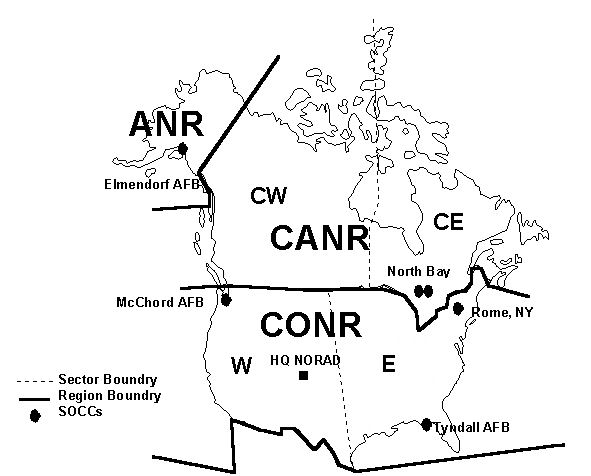
North American Aerospace Defense Command (NORAD ), known until March 1981 as the North American Air Defense Command, is a combined organization of the United States and Canada that provides aerospace warning, air sovereignty, and protection for Canada and the continental United States. Headquarters for NORAD and the NORAD/United States Northern Command (USNORTHCOM) center are located at Peterson Space Force Base in El Paso County, near Colorado Springs, Colorado. The nearby Cheyenne Mountain Complex has the Alternate Command Center. The NORAD commander and deputy commander (CINCNORAD) are, respectively, a United States four-star general or equivalent and a Canadian lieutenant-general or equivalent. Organization CINCNORAD maintains the NORAD headquarters at Peterson Space Force Base near Colorado Springs, Colorado. The NORAD and USNORTHCOM Command Center at Peterson SFB serves as a central collection and coordination facility for a worldwide system of sensors designed ... [...More Info...] [...Related Items...] OR: [Wikipedia] [Google] [Baidu] |
White Alice Communications System
The White Alice Communications System (WACS, "White Alice" colloquially) was a United States Air Force telecommunication network with 80 radio stations constructed in Alaska during the Cold War. It used tropospheric scatter for over-the-horizon links and microwave relay for shorter line-of-sight links. Sites were characterized by large parabolic, tropospheric scatter antennas as well as smaller microwave dishes for point-to-point links. The system connected remote Air Force sites in Alaska, such as Aircraft Control and Warning (AC&W), Distant Early Warning Line (DEW Line) and Ballistic Missile Early Warning System (BMEWS), to command and control facilities and in some cases it was used for civilian phone calls. The network was originally operated by the USAF, but was turned over to RCA for operations after 1969. The opening of satellite communication links in the 1970s made the system obsolete, and in 1979 it was replaced by an RCA satellite link that connected all of the stations ... [...More Info...] [...Related Items...] OR: [Wikipedia] [Google] [Baidu] |
Air Force Communications Service
The atmosphere of Earth is the layer of gases, known collectively as air, retained by Gravity of Earth, Earth's gravity that surrounds the planet and forms its planetary atmosphere. The atmosphere of Earth protects life on Earth by creating Atmospheric pressure, pressure allowing for Water#Liquid water, liquid water to exist on the Earth's Planetary surface, surface, absorbing ultraviolet Solar irradiance, solar radiation, warming the surface through heat retention (greenhouse effect), and reducing temperature extremes between Daytime, day and night (the diurnal temperature variation). By mole fraction (i.e., by number of molecules), dry air contains 78.08% nitrogen, 20.95% oxygen, 0.93% argon, 0.04% Carbon dioxide in Earth's atmosphere, carbon dioxide, and small amounts of other gases. Air also contains a variable amount of Water vapor#Water vapor in Earth's atmosphere, water vapor, on average around 1% at sea level, and 0.4% over the entire atmosphere. Air composition, tempera ... [...More Info...] [...Related Items...] OR: [Wikipedia] [Google] [Baidu] |
Clear AFS
Clear Space Force Station is a United States Space Force radar station for detecting incoming ICBMs and submarine-launched ballistic missiles to NORAD's command center and to provide Space Surveillance data to the United States Space Force. Clear's AN/FPS-123 Upgraded Early Warning Radar is part of the Solid State Phased Array Radar System (SSPARS) which also includes those at Beale AFB, Cape Cod Space Force Station, RAF Fylingdales and Thule Site J. The "historic property" was one of the Alaska World War II Army Airfields and later a Cold War BMEWS site providing NORAD data to Colorado's BMEWS Central Computer and Display Facility (CC&DF). In addition to the "original camp area" with buildings still in use today, areas of the station include the airfield , the "SSPARS Site" the technical site (Utilador, BMEWS reflectors, support buildings, power plant), and the composite site (two permanent dormitories, a mess hall, recreation area, and administrative area). In addition to ... [...More Info...] [...Related Items...] OR: [Wikipedia] [Google] [Baidu] |
Kotzebue AFS
Kotzebue Air Force Station (AAC ID: F-24, LRR ID: A-12) is a closed United States Air Force General Surveillance Radar station. It is located south of Kotzebue, Alaska. The ground control intercept (GCI) station was closed on 1 November 1983, and was re-designated as a Long Range Radar (LRR) site as part of the Alaska Radar System. Today, it remains active as part of the Alaska NORAD Region under the jurisdiction of the 611th Air Support Group, Elmendorf AFB, Alaska. History Kotzebue AFS was a continental defence radar station constructed to provide the United States Air Force early warning of an attack by the Soviet Union on Alaska. Construction of the station, began in 1957 and was completed in April 1958. The Army Transportation Corps undertook the project. The station site was located on the Kotzebue Sound of Western Alaska, and equipment and construction material was floated by LST or a barge to a dock built on the coast . Initially, there were no roads, which had to b ... [...More Info...] [...Related Items...] OR: [Wikipedia] [Google] [Baidu] |
Fort Yukon AFS
Fort Yukon Long Range Radar Site is a radar site of the United States Air Force. It is located east-southeast of Fort Yukon, Alaska. It was the former Fort Yukon Air Force Station (AAC ID: F-14, LRR ID: A-01), a General Surveillance Radar station. The ground control intercept (GCI) station was closed on 1 November 1983, and was redesignated as a Long Range Radar (LRR) site as part of the Alaska Radar System. Today, it remains active as part of the Alaska NORAD Region under the jurisdiction of the 611th Air and Space Operations Center, Elmendorf AFB, Alaska. History Fort Yukon AFS was a continental defence radar station constructed to provide the United States Air Force early warning of an attack by the Soviet Union on Alaska. The station was opened in 1958 as a Ground-Control Intercept (GCI) and warning station, operated by the 709th Aircraft Control and Warning Squadron (AC&W Sq). The squadron operated AN/FPS-3, AN/FPS-20, and AN/FPS-6 radars. As a GCI station, the squadron ... [...More Info...] [...Related Items...] OR: [Wikipedia] [Google] [Baidu] |
Cape Lisburne AFS
Cape Lisburne Air Force Station (AAC ID: F-07, LRR ID: A-19, DEW ID: LIZ-1) is a closed United States Air Force General Surveillance Radar station. It is located west-southwest of Point Barrow, Alaska. The radar surveillance station was closed on 1 November 1983, and was re-designated as a Long Range Radar (LRR) site as part of the Alaska Radar System. Today, it remains active as part of the Alaska NORAD Region, under the jurisdiction of the 611th Air and Space Operations Center, Elmendorf AFB, Alaska. History Cape Lisburne AFS was a continental defence radar station constructed to provide the United States Air Force early warning of an attack by the Soviet Union on Alaska. It was one of the ten original radar surveillance sites constructed during the early 1950s, to establish a permanent air defense system in Alaska. An assignment to the station was one of the most remote tours which an Airman could serve during its operational lifetime. The station was located at Cape Lis ... [...More Info...] [...Related Items...] OR: [Wikipedia] [Google] [Baidu] |


