|
Munich Gravel Plain
The Munich gravel plain (german: Münchner Schotterebene) is an outwash plain in Upper Bavaria, Germany, formed during Late Pleistocene glacial periods. Characterized by its very wide extension, it comprises sandur terraces and the floodplain of the Isar river. These most recent deposits overlie the Neogene Molasse basin of the Alpine Foreland, which in contrast comprises fine-grained fluviatile and lacustrine facies. Location The plain covers a triangular area of around 1500 km2 (= 579.15 mi2). The three corners corresponded with the town of Weyarn, between Miesbach and Holzkirchen in the southeast, Moosburg an der Isar in the northeast and Maisach in the west. Munich city and nearly all its peripheral districts are situated on top of the flat gravel plain. As a consequence the city, in contrast to the surrounding counties in the north, south and west, has almost no topography, topographic features. However, the waters of the Isar river have cut into the Quaternar ... [...More Info...] [...Related Items...] OR: [Wikipedia] [Google] [Baidu] |
Moosburg An Der Isar
Moosburg an der Isar (Central Bavarian: ''Mooschbuag on da Isa'') is a town in the ''Landkreis'' Freising of Bavaria, Germany. The oldest town between Regensburg and Italy, it lies on the river Isar at an altitude of 421 m (1381 ft). It has 18,033 inhabitants (2016) and covers an area of 44 km2. It is easily reached by the A 92 autobahn and regional trains on the Munich–Regensburg line. Furthermore, it takes just 20 minutes to get to Munich Airport. Moosburg is popular with commuters who travel to Munich, Freising, and Munich Airport. There is considerable industry in the town consisting of chemical, electro-technical, food processing, and machine-building plants. History There was a Benedictine abbey in Moosburg in the 8th century: a cluster of dwellings and artisans sprang up around it. Duke Heinrich der Löwe started the construction of the Kastulus Minster (cathedral) in 1171, dedicated to Saint Castulus – whose supposed relics were brought to the cit ... [...More Info...] [...Related Items...] OR: [Wikipedia] [Google] [Baidu] |
Mangfall
The Mangfall is a river of Upper Bavaria, Germany. The Mangfall is the outflow of the Tegernsee lake and discharges in Rosenheim from the left into the Inn. It is long. Towns and villages on the Mangfall * Gmund am Tegernsee * Valley * Weyarn * Grub (district of Valley) * Feldkirchen-Westerham * Feldolling * Bruckmühl * (district of Bruckmühl) * (district of Bruckmühl) * Bad Aibling * Kolbermoor * Rosenheim See also *List of rivers of Bavaria A list of rivers of Bavaria, Germany: A * Aalbach *Abens * Ach * Afferbach * Affinger Bach * Ailsbach *Aisch * Aiterach *Alpbach *Alster * Altmühl *Alz * Amper * Anlauter * Arbach * Arbachgraben *Aschaff * Aschbach * Attel * Aubach, tributary of ... References External links bike trail along the MangfallFlux of the Mangfall in Rosenheim during the last 30 days {{Authority control Rivers of Bavaria Miesbach (district) Rosenheim (district) Rivers of Germany ... [...More Info...] [...Related Items...] OR: [Wikipedia] [Google] [Baidu] |
Würm Glaciation
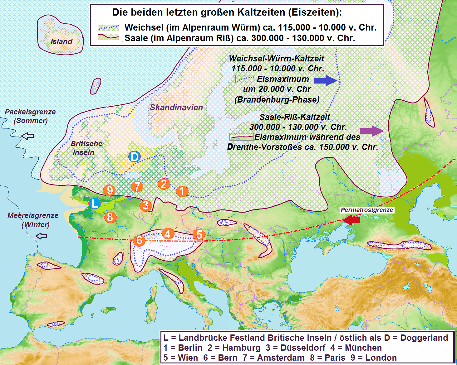
The Würm glaciation or Würm stage (german: Würm-Kaltzeit or ''Würm-Glazial'', colloquially often also ''Würmeiszeit'' or ''Würmzeit''; cf. ice age), usually referred to in the literature as the Würm (often spelled "Wurm"), was the last glacial period in the Alpine region. It is the youngest of the major glaciations of the region that extended beyond the Alps themselves. Like most of the other ice ages of the Pleistocene epoch, it is named after a river, in this case the Würm in Bavaria, a tributary of the Amper. The Würm ice age can be dated to about 115,000 to 11,700 years ago, but sources differ about the dates, depending on whether the long transition phases between the glacials and interglacials (warmer periods) are allocated to one or other of those periods. The average annual temperatures during the Würm ice age in the Alpine Foreland were below −3 °C (today +7 °C). That has been determined from changes in the vegetation (pollen analysis), as well a ... [...More Info...] [...Related Items...] OR: [Wikipedia] [Google] [Baidu] |
Riss Glaciation
The Riss glaciation, Riss Glaciation, Riss ice age, Riss Ice Age, Riss glacial or Riss Glacial (german: Riß-Kaltzeit, ', ' or (obsolete) ') is the second youngest glaciation of the Pleistocene epoch in the traditional, quadripartite glacial classification of the Alps. The literature variously dates it to between about 300,000 to 130,000 years ago and 347,000 to 128,000 years ago. It coincides with the glaciation of North Germany. The name goes back to and who named this cold period after the river in Upper Swabia in their three-volume work ' ("The Alps in the Ice Age") published between 1901 and 1909. Boundaries and division The Riss glaciation was defined by Penck and Brückner as the Lower (''Niedere'') or Younger Old Moraines and Old Terminal Moraines High Terraces (''Jüngere Altmoränen und Alt-Endmoränen-Hochterrassen''). The type locality lies near Biberach an der Riß where the end of the northeastern Rhine Glacier stood. Results gained from over a century of resea ... [...More Info...] [...Related Items...] OR: [Wikipedia] [Google] [Baidu] |
Mindel Glaciation
The Mindel glaciation (german: Mindel-Kaltzeit, also ''Mindel-Glazial'', ''Mindel-Komplex'' or, colloquially, ''Mindel-Eiszeit'') is the third youngest glacial stage in the Alps. Its name was coined by Albrecht Penck and Eduard Brückner, who named it after the Swabian river, the Mindel. The Mindel glacial occurred in the Middle Pleistocene; it was preceded by the Haslach-Mindel interglacial (often regarded as part of Günz) and succeeded by the Mindel-Riss interglacial ( Holstein interglacial). The Mindel glaciation is commonly correlated to the Elster glaciation of northern Europe. The more precise timing is controversial since Mindel is commonly correlated to two different marine isotope stages, MIS 12 (478–424 thousand years ago) and MIS 10 (374–337 thousand years ago). This ambiguity is much related to the correlation problem described in more detail in the article 'Elster glaciation'. See also *Timeline of glaciation *Glaciology Glaciology (; ) is the scientific ... [...More Info...] [...Related Items...] OR: [Wikipedia] [Google] [Baidu] |
Interglacial
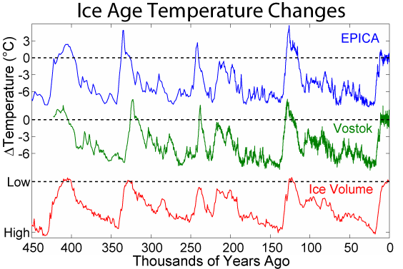
An interglacial period (or alternatively interglacial, interglaciation) is a geological interval of warmer global average temperature lasting thousands of years that separates consecutive glacial periods within an ice age. The current Holocene interglacial began at the end of the Pleistocene, about 11,700 years ago. Pleistocene During the 2.5 million years of the Pleistocene, numerous glacials, or significant advances of continental ice sheets, in North America and Europe, occurred at intervals of approximately 40,000 to 100,000 years. The long glacial periods were separated by more temperate and shorter interglacials. During interglacials, such as the present one, the climate warms and the tundra recedes polewards following the ice sheets. Forests return to areas that once supported tundra vegetation. Interglacials are identified on land or in shallow epicontinental seas by their paleontology. Floral and faunal remains of species pointing to temperate climate and indicating a s ... [...More Info...] [...Related Items...] OR: [Wikipedia] [Google] [Baidu] |
Central Eastern Alps
The Central Eastern Alps (german: Zentralalpen or Zentrale Ostalpen), also referred to as Austrian Central Alps (german: Österreichische Zentralalpen) or just Central Alps, comprise the main chain of the Eastern Alps in Austria and the adjacent regions of Switzerland, Liechtenstein, Italy and Slovenia. South them is the Southern Limestone Alps. The term "Central Alps" is very common in the Geography of Austria as one of the seven major landscape regions of the country. "Central Eastern Alps" is usually used in connection with the Alpine Club classification of the Eastern Alps (''Alpenvereinseinteilung'', AVE). The Central Alps form the eastern part of the Alpine divide, its central chain of mountains, as well as those ranges that extend or accompany it to the north and south. The highest mountain in the Austrian Central Alps is Grossglockner at . Location The Central Alps have the highest peaks of the Eastern Alps, and are located between the Northern Limestone Alps and the ... [...More Info...] [...Related Items...] OR: [Wikipedia] [Google] [Baidu] |
Stratigraphy
Stratigraphy is a branch of geology concerned with the study of rock (geology), rock layers (Stratum, strata) and layering (stratification). It is primarily used in the study of sedimentary rock, sedimentary and layered volcanic rocks. Stratigraphy has three related subfields: lithostratigraphy (lithologic stratigraphy), biostratigraphy (biologic stratigraphy), and chronostratigraphy (stratigraphy by age). Historical development Catholic priest Nicholas Steno established the theoretical basis for stratigraphy when he introduced the law of superposition, the principle of original horizontality and the principle of lateral continuity in a 1669 work on the fossilization of organic remains in layers of sediment. The first practical large-scale application of stratigraphy was by William Smith (geologist), William Smith in the 1790s and early 19th century. Known as the "Father of English geology", Smith recognized the significance of Stratum, strata or rock layering and the importance ... [...More Info...] [...Related Items...] OR: [Wikipedia] [Google] [Baidu] |
Ottobrunn Ansicht Von Südwesten 16x9 2011-11-06
Ottobrunn () is a municipality southeast of Munich, Bavaria, Germany, founded in 1955. Ottobrunn consists of mainly semi-detached and detached houses, as well as extensive garden areas. Ottobrunn is also the German Headquarters of Airbus Defense and Space (former European Aeronautic Defence and Space Company (EADS)), with the majority of Airbus DS grounds situated in the neighbouring community of Taufkirchen. According to the Federal Statistical Office of Germany, the municipality is the second-most densely populated in all of Germany, trailing only Munich, and ahead of Berlin. History The town's center was established in the mid 1980s with the town hall (1983) and the community centre (1986). The community centre was named after the German-Italian composer Ermanno Wolf-Ferrari who lived in Ottobrunn between 1915 and 1931. There is a memorial Doric order column, called the Ottosäule, made by the chiseler Anton Ripfel, commemorating the day in 1832 when Otto of Greece travele ... [...More Info...] [...Related Items...] OR: [Wikipedia] [Google] [Baidu] |
Gravel
Gravel is a loose aggregation of rock fragments. Gravel occurs naturally throughout the world as a result of sedimentary and erosive geologic processes; it is also produced in large quantities commercially as crushed stone. Gravel is classified by particle size range and includes size classes from granule- to boulder-sized fragments. In the Udden-Wentworth scale gravel is categorized into granular gravel () and pebble gravel (). ISO 14688 grades gravels as fine, medium, and coarse, with ranges 2–6.3 mm to 20–63 mm. One cubic metre of gravel typically weighs about 1,800 kg (or a cubic yard weighs about 3,000 lb). Gravel is an important commercial product, with a number of applications. Almost half of all gravel production is used as aggregate for concrete. Much of the rest is used for road construction, either in the road base or as the road surface (with or without asphalt or other binders.) Naturally occurring porous gravel deposits have a ... [...More Info...] [...Related Items...] OR: [Wikipedia] [Google] [Baidu] |
Quaternary
The Quaternary ( ) is the current and most recent of the three periods of the Cenozoic Era in the geologic time scale of the International Commission on Stratigraphy (ICS). It follows the Neogene Period and spans from 2.58 million years ago to the present. The Quaternary Period is divided into two epochs: the Pleistocene (2.58 million years ago to 11.7 thousand years ago) and the Holocene (11.7 thousand years ago to today, although a third epoch, the Anthropocene, has been proposed but is not yet officially recognised by the ICS). The Quaternary Period is typically defined by the cyclic growth and decay of continental ice sheets related to the Milankovitch cycles and the associated climate and environmental changes that they caused. Research history In 1759 Giovanni Arduino proposed that the geological strata of northern Italy could be divided into four successive formations or "orders" ( it, quattro ordini). The term "quaternary" was introduced by Jules Desnoye ... [...More Info...] [...Related Items...] OR: [Wikipedia] [Google] [Baidu] |


