|
Mount Wood (Montana)
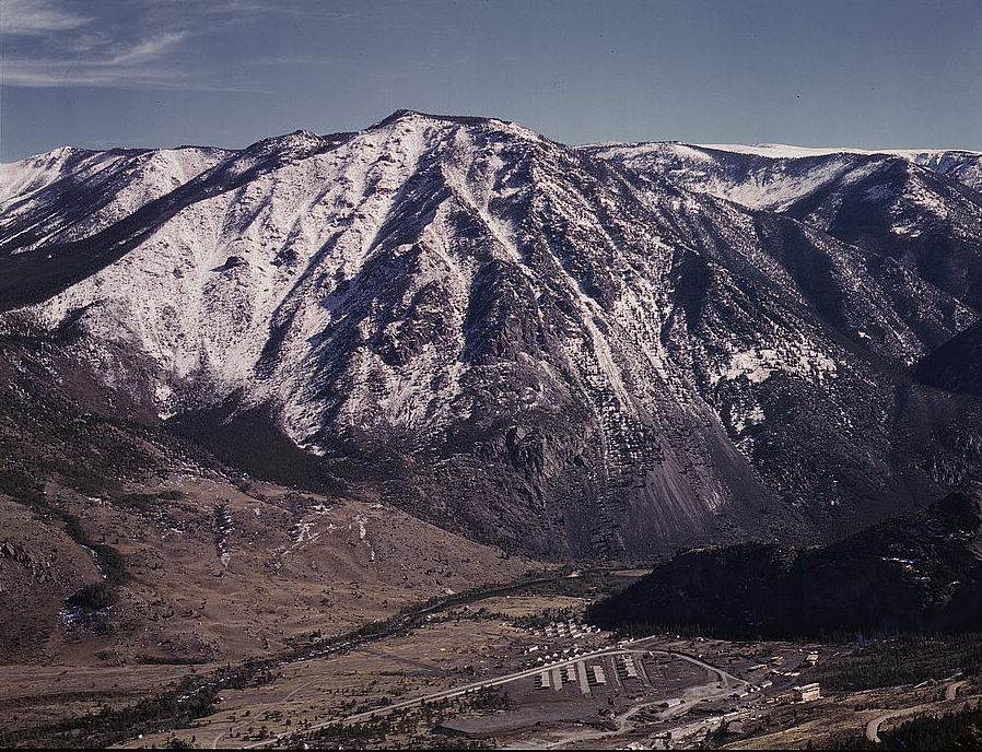
Mount Wood () is the highest summit in the Granite Range, a subrange of the Beartooth Mountains in the U.S. state of Montana. It is located within the Custer National Forest. Climate References Wood Wood is a porous and fibrous structural tissue found in the stems and roots of trees and other woody plants. It is an organic materiala natural composite of cellulose fibers that are strong in tension and embedded in a matrix of lignin ... Mountains of Stillwater County, Montana {{StillwaterCountyMT-geo-stub ... [...More Info...] [...Related Items...] OR: [Wikipedia] [Google] [Baidu] |
Stillwater County, Montana
Stillwater County is a county in the U.S. state of Montana. As of the 2020 census, the population was 8,963. Its county seat is Columbus. Geography According to the United States Census Bureau, the county has a total area of , of which is land and (0.5%) is water. Major highways * Interstate 90 * U.S. Highway 10 (Former) * Montana Highway 78 Adjacent counties * Golden Valley County - north * Yellowstone County - east * Carbon County - south * Park County - southwest * Sweet Grass County - west National protected areas * Custer National Forest (part) * Grass Lake National Wildlife Refuge * Hailstone National Wildlife Refuge Demographics 2000 census As of the 2000 United States census, there were 8,195 people, 3,234 households, and 2,347 families in the county. The population density was 5 people per square mile (2/km2). There were 3,947 housing units at an average density of 2 per square mile (1/km2). The racial makeup of the county was 96.82% White, 0.13% ... [...More Info...] [...Related Items...] OR: [Wikipedia] [Google] [Baidu] |
United States
The United States of America (U.S.A. or USA), commonly known as the United States (U.S. or US) or America, is a country primarily located in North America. It consists of 50 states, a federal district, five major unincorporated territories, nine Minor Outlying Islands, and 326 Indian reservations. The United States is also in free association with three Pacific Island sovereign states: the Federated States of Micronesia, the Marshall Islands, and the Republic of Palau. It is the world's third-largest country by both land and total area. It shares land borders with Canada to its north and with Mexico to its south and has maritime borders with the Bahamas, Cuba, Russia, and other nations. With a population of over 333 million, it is the most populous country in the Americas and the third most populous in the world. The national capital of the United States is Washington, D.C. and its most populous city and principal financial center is New York City. Paleo-Americ ... [...More Info...] [...Related Items...] OR: [Wikipedia] [Google] [Baidu] |
Beartooth Range
The Beartooth Mountains are located in south central Montana and northwest Wyoming, U.S. and are part of the Absaroka-Beartooth Wilderness, within Custer, Gallatin and Shoshone National Forests. The Beartooths are the location of Granite Peak, which at is the highest point in the state of Montana. The mountains are just northeast of Yellowstone National Park and are part of the Greater Yellowstone Ecosystem. The mountains are traversed by road via the Beartooth Highway (U.S. 212) with the highest elevation at Beartooth Pass ). The name of the mountain range is attributed to a rugged peak found in the range, Beartooth Peak, that has the appearance of a bear's tooth. The Beartooth Mountains sit upon the larger Beartooth Plateau. History The remoteness of the region contributed to its obscurity until the 1870s. The Crow tribe of Native Americans used the valleys of the mountains for hunting game animals and for winter shelter from the harsh winds of the plains. Though trappers e ... [...More Info...] [...Related Items...] OR: [Wikipedia] [Google] [Baidu] |
United States Geological Survey
The United States Geological Survey (USGS), formerly simply known as the Geological Survey, is a scientific agency of the United States government. The scientists of the USGS study the landscape of the United States, its natural resources, and the natural hazards that threaten it. The organization's work spans the disciplines of biology, geography, geology, and hydrology. The USGS is a fact-finding research organization with no regulatory responsibility. The agency was founded on March 3, 1879. The USGS is a bureau of the United States Department of the Interior; it is that department's sole scientific agency. The USGS employs approximately 8,670 people and is headquartered in Reston, Virginia. The USGS also has major offices near Lakewood, Colorado, at the Denver Federal Center, and Menlo Park, California. The current motto of the USGS, in use since August 1997, is "science for a changing world". The agency's previous slogan, adopted on the occasion of its hundredt ... [...More Info...] [...Related Items...] OR: [Wikipedia] [Google] [Baidu] |
Granite Range (Montana)
The Granite Range, el. , is a mountain range southwest of Absarokee, Montana in Stillwater County, Montana. See also * List of mountain ranges in Montana This is a list of mountain ranges in the state of Montana. Montana is the fourth largest state in the United States and is well known for its mountains. The name "Montana" means "mountainous" in Latin. Representative James Mitchell Ashley ( R-Ohi ... Notes {{Montana Mountain ranges of Montana Landforms of Stillwater County, Montana ... [...More Info...] [...Related Items...] OR: [Wikipedia] [Google] [Baidu] |
Beartooth Mountains
The Beartooth Mountains are located in south central Montana and northwest Wyoming, U.S. and are part of the Absaroka-Beartooth Wilderness, within Custer, Gallatin and Shoshone National Forests. The Beartooths are the location of Granite Peak, which at is the highest point in the state of Montana. The mountains are just northeast of Yellowstone National Park and are part of the Greater Yellowstone Ecosystem. The mountains are traversed by road via the Beartooth Highway (U.S. 212) with the highest elevation at Beartooth Pass ). The name of the mountain range is attributed to a rugged peak found in the range, Beartooth Peak, that has the appearance of a bear's tooth. The Beartooth Mountains sit upon the larger Beartooth Plateau. History The remoteness of the region contributed to its obscurity until the 1870s. The Crow tribe of Native Americans used the valleys of the mountains for hunting game animals and for winter shelter from the harsh winds of the plains. Though trappers e ... [...More Info...] [...Related Items...] OR: [Wikipedia] [Google] [Baidu] |
Montana
Montana () is a state in the Mountain West division of the Western United States. It is bordered by Idaho to the west, North Dakota and South Dakota to the east, Wyoming to the south, and the Canadian provinces of Alberta, British Columbia, and Saskatchewan to the north. It is the fourth-largest state by area, the eighth-least populous state, and the third-least densely populated state. Its state capital is Helena. The western half of Montana contains numerous mountain ranges, while the eastern half is characterized by western prairie terrain and badlands, with smaller mountain ranges found throughout the state. Montana has no official nickname but several unofficial ones, most notably "Big Sky Country", "The Treasure State", "Land of the Shining Mountains", and " The Last Best Place". The economy is primarily based on agriculture, including ranching and cereal grain farming. Other significant economic resources include oil, gas, coal, mining, and lumber. The health ca ... [...More Info...] [...Related Items...] OR: [Wikipedia] [Google] [Baidu] |
Custer National Forest
Custer National Forest is located primarily in the south central part of the U.S. state of Montana but also has separate sections in northwestern South Dakota. With a total area of , the forest comprises over 10 separate sections. While in the westernmost sections, Custer National Forest is a part of the Greater Yellowstone Ecosystem, the easternmost sections are a combination of forest "islands" and grasslands. A portion of the forest is also part of the Absaroka-Beartooth Wilderness and constitutes over a third of the wilderness land. South of Red Lodge, Montana, the Beartooth Highway (U.S. 212) passes through the forest en route to Yellowstone National Park. The eastern areas are dominated by large stands of ponderosa pine surrounded by grasslands, which are often leased to local ranchers for cattle grazing. Administration Since 2014, the Custer and Gallatin National Forests are managed together as the Custer-Gallatin National Forest with headquarters in Bozeman, Montana. The ... [...More Info...] [...Related Items...] OR: [Wikipedia] [Google] [Baidu] |


