|
Mount Rogers Cluster
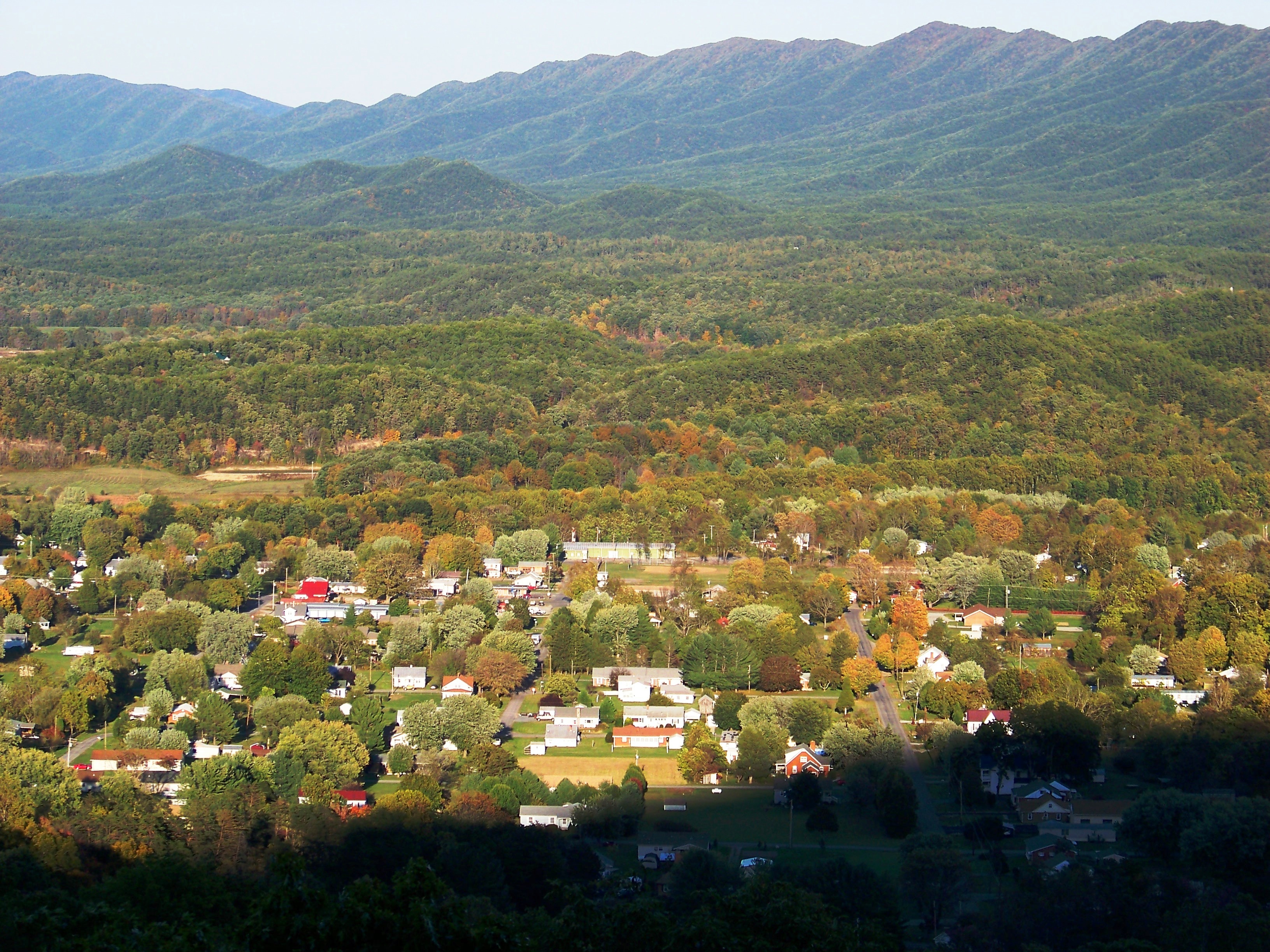
The Mount Rogers Cluster is a region recognized by The Wilderness Society for its unique high elevation mountains, vistas, trout streams and wildlife habitat. The heart of the region is Mount Rogers, the highest mountain in Virginia. The area extends over the Mount Rogers National Recreation Area and into part of the Cherokee National Forest.Virginia's Mountain Treasures, report issued by The Wilderness Society, May, 1999 With elevations above 5000 feet, the area is unlike any other in Virginia. The high elevations have a Canadian-type climate with a spruce-fir remnant forest and high timbered ridges opening to grassy alpine meadows similar to The Montana Big Sky country. Many trails offer a summer escape from nearby humid lowlands. Description The Mount Rogers Wilderness Cluster contains wilderness areas, a National Scenic Area and wildlands recognized by the Wilderness Society as "Mountain Treasures", areas that are worthy of protection from logging and road constructi ... [...More Info...] [...Related Items...] OR: [Wikipedia] [Google] [Baidu] |
The Wilderness Society (United States)
The Wilderness Society is an American non-profit land conservation organization that is dedicated to protecting natural areas and federal public lands in the United States. They advocate for the designation of federal wilderness areas and other protective designations, such as for national monuments. They support balanced uses of public lands, and advocate for federal politicians to enact various land conservation and balanced land use proposals. The Wilderness Society also engages in a number of ancillary activities, including education and outreach, and hosts one of the most valuable collections of Ansel Adams photographs at their headquarters in Washington, D.C. The Wilderness Society specializes in issues involving lands under the management of federal agencies; such lands include national parks, national forests, national wildlife refuges, and areas overseen by the Bureau of Land Management. In the early 21st century, the society has been active in fighting recent pol ... [...More Info...] [...Related Items...] OR: [Wikipedia] [Google] [Baidu] |
Mount Rogers Crest Zone
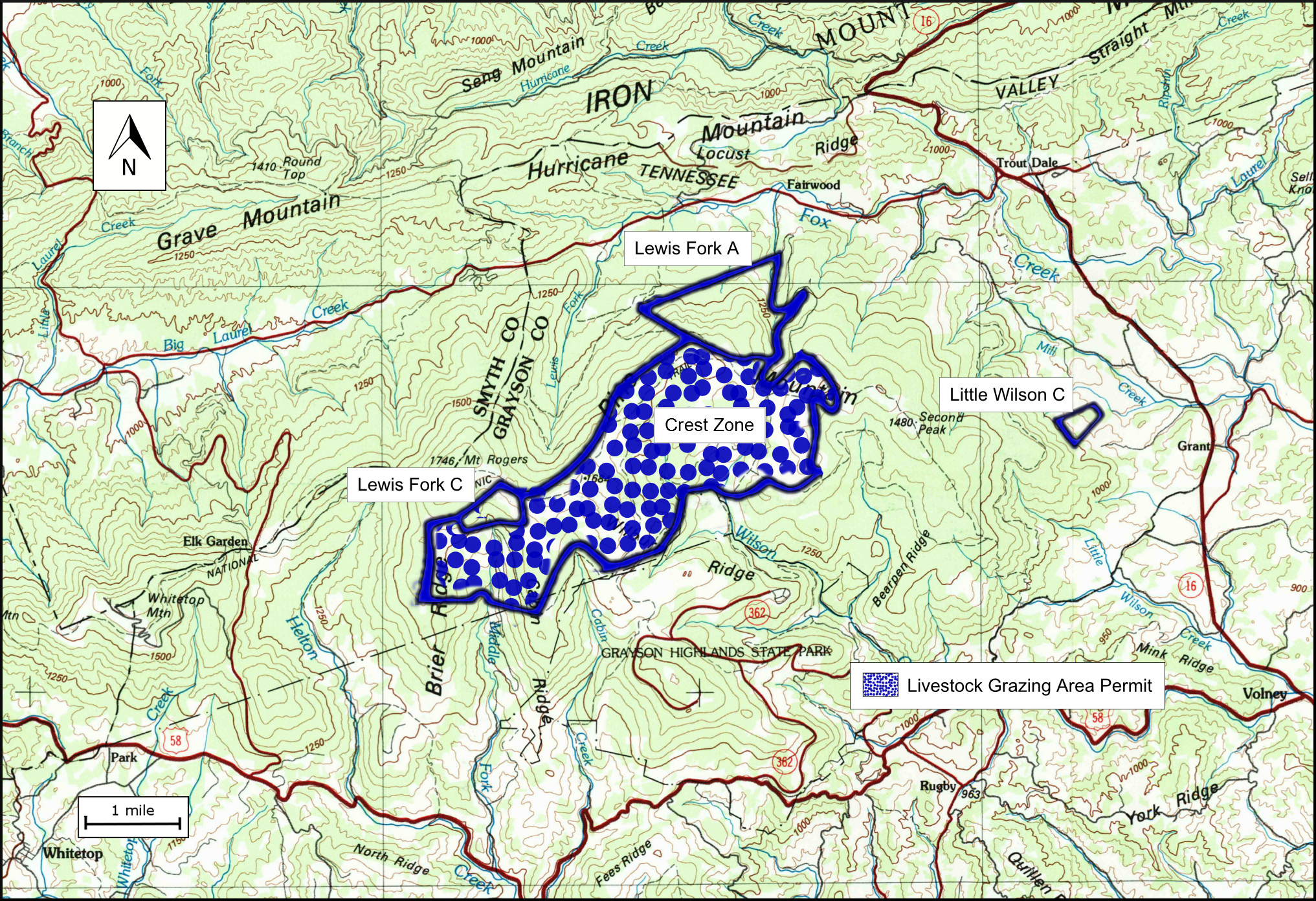
Mount Rogers Crest Zone is a wildland in the George Washington and Jefferson National Forests of western Virginia that has been recognized by the Wilderness Society as a special place worthy of protection from logging and road construction. The Wilderness Society has designated the area as a "Mountain Treasure".Virginia's Mountain Treasures, report issued by The Wilderness Society, May, 1999 One of the most visited locations in the Mount Rogers National Recreation area, the Mount Rogers Crest Zone offers scenic views of nearby Rhododendron Gap and other high points, and a diversity of boreal species in lands surrounding Mount Rogers, the highest point in Virginia. The area is part of the ''Mount Rogers Cluster''. Location and access The area is located in the Appalachian Mountains of Southwestern Virginia about 5 miles southwest of Troutdale, Virginia between the Lewis Fork Wilderness Area and the Little Wilson Creek Wilderness Area. The Appalachian Trail passes through the a ... [...More Info...] [...Related Items...] OR: [Wikipedia] [Google] [Baidu] |
Barbours Creek-Shawvers Run Cluster
The Barbours Creek-Shawvers Run Cluster is a region in the Jefferson National Forest recognized by The Wilderness Society for its unique high elevation mountains, vistas, trout streams and wildlife habitat. With over 25,000 acres in a remote corner of the national forest, the cluster provides protection for black bear, clean water, backcountry hiking, and scenic beauty. Description The Barbours Creek/Shawvers Run Wilderness Cluster contains wilderness areas, and wildlands recognized by the Wilderness Society as "Mountain Treasures", areas that are worthy of protection from logging and road construction. The areas in the cluster are: *Wilderness Areas **Barbours Creek Wilderness **Shawvers Run Wilderness *wild areas in the Jefferson National Forest recognized by the Wilderness Society as "Mountain Treasures" **Hoop hole ** Barbours Creek Wilderness Addition **Potts Arm * Toms Knob, a wild area in the George Washington National Forest recognized by the Wilderness Society as a "Mou ... [...More Info...] [...Related Items...] OR: [Wikipedia] [Google] [Baidu] |
Craig Creek Cluster
The Craig Creek Cluster is a region recognized by The Wilderness Society for its unique high elevation mountains, vistas, trout streams and wildlife habitat. The cluster contains wildlands and wilderness areas along Craig Creek, a 65-mile long creek with headwaters at the Brush Mountain Wilderness near Blacksburg. Popular for hiking, canoeing, mountain biking, hunting, horseback riding, and fishing, the area offers an opportunity for secluded recreation. During the summer months the area is an escape from other public lands that are busy with visitors. Description The Craig Creek Wilderness Cluster contains wilderness areas and wildlands recognized by the Wilderness Society as “Mountain Treasures”, areas that are worthy of protection from logging and road construction. The areas in the cluster are: *Wilderness Areas ** Brush Mountain Wilderness **Brush Mountain East Wilderness *Wildareas recognized by the Wilderness Society as “Mountain Treasures” **Patterson Mountai ... [...More Info...] [...Related Items...] OR: [Wikipedia] [Google] [Baidu] |
Glenwood Cluster
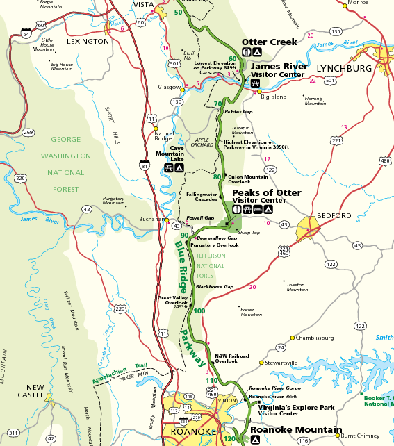
The Glenwood Cluster is a region in the George Washington and Jefferson National Forests recognized by The Wilderness Society for its rich biodiversity, scenery, wildflower displays, cold-water trout streams and horse trails. It offers a unique habitat for rare plants, salamanders and other rare species. The Blue Ridge Parkway and the Appalachian Trail traverse the area, giving ready access with views to the east of the Piedmont region and to the west of the Valley of Virginia.Virginia's Mountain Treasures, report issued by The Wilderness Society, May, 1999 Description The region includes wilderness areas protected by Congressional action, inventoried wilderness, and uninventoried areas recognized by the Wilderness Society as worthy of protection from timbering and roads. A corridor along the Blue Ridge Parkway, managed by the National Park Service, and forest service land in the Glenwood Ranger District act as a buffer for the protected areas. The following areas are in the ... [...More Info...] [...Related Items...] OR: [Wikipedia] [Google] [Baidu] |
Stream Capture
Stream capture, river capture, river piracy or stream piracy is a geomorphological phenomenon occurring when a stream or river drainage system or watershed is diverted from its own bed, and flows instead down the bed of a neighbouring stream. This can happen for several reasons, including: * Tectonic earth movements, where the slope of the land changes, and the stream is tipped out of its former course *Natural damming, such as by a landslide or ice sheet *Erosion, either ** Headward erosion of one stream valley upwards into another, or **Lateral erosion of a meander through the higher ground dividing the adjacent streams. **Within an area of karst topography, where streams may ''sink'', or flow underground (a sinking or losing stream) and then reappear in a nearby stream valley *Glacier retreat The additional water flowing down the capturing stream may accelerate erosion and encourage the development of a canyon (gorge). The now-dry valley of the original stream is known ... [...More Info...] [...Related Items...] OR: [Wikipedia] [Google] [Baidu] |
Rhyolite
Rhyolite ( ) is the most silica-rich of volcanic rocks. It is generally glassy or fine-grained ( aphanitic) in texture, but may be porphyritic, containing larger mineral crystals ( phenocrysts) in an otherwise fine-grained groundmass. The mineral assemblage is predominantly quartz, sanidine, and plagioclase. It is the extrusive equivalent to granite. Rhyolitic magma is extremely viscous, due to its high silica content. This favors explosive eruptions over effusive eruptions, so this type of magma is more often erupted as pyroclastic rock than as lava flows. Rhyolitic ash-flow tuffs are among the most voluminous of continental igneous rock formations. Rhyolitic tuff has been extensively used for construction. Obsidian, which is rhyolitic volcanic glass, has been used for tools from prehistoric times to the present day because it can be shaped to an extremely sharp edge. Rhyolitic pumice finds use as an abrasive, in concrete, and as a soil amendment. Description R ... [...More Info...] [...Related Items...] OR: [Wikipedia] [Google] [Baidu] |
Salamanders
Salamanders are a group of amphibians typically characterized by their lizard-like appearance, with slender bodies, blunt snouts, short limbs projecting at right angles to the body, and the presence of a tail in both larvae and adults. All ten extant salamander families are grouped together under the order Urodela. Salamander diversity is highest in eastern North America, especially in the Appalachian Mountains; most species are found in the Holarctic realm, with some species present in the Neotropical realm. Salamanders rarely have more than four toes on their front legs and five on their rear legs, but some species have fewer digits and others lack hind limbs. Their permeable skin usually makes them reliant on habitats in or near water or other cool, damp places. Some salamander species are fully aquatic throughout their lives, some take to the water intermittently, and others are entirely terrestrial as adults. This group of amphibians is capable of regenerating lost li ... [...More Info...] [...Related Items...] OR: [Wikipedia] [Google] [Baidu] |
Mount Rogers National Recreation Area LOC 82696165
Mount is often used as part of the name of specific mountains, e.g. Mount Everest. Mount or Mounts may also refer to: Places * Mount, Cornwall, a village in Warleggan parish, England * Mount, Perranzabuloe, a hamlet in Perranzabuloe parish, Cornwall, England * Mounts, Indiana, a community in Gibson County, Indiana, United States People * Mount (surname) * William L. Mounts (1862–1929), American lawyer and politician Computing and software * Mount (computing), the process of making a file system accessible * Mount (Unix), the utility in Unix-like operating systems which mounts file systems Displays and equipment * Mount, a fixed point for attaching equipment, such as a hardpoint on an airframe * Mounting board, in picture framing * Mount, a hanging scroll for mounting paintings * Mount, to display an item on a heavy backing such as foamcore, e.g.: ** To pin a biological specimen, on a heavy backing in a stretched stable position for ease of dissection or display ** To ... [...More Info...] [...Related Items...] OR: [Wikipedia] [Google] [Baidu] |
Beaverdam Creek (conservation Area)
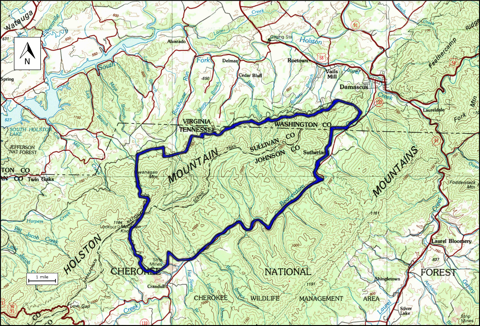
Beaverdam Creek (conservation area), a wildland in the George Washington and Jefferson National Forests of western Virginia and the Cherokee National Forest of eastern Tennessee, has been recognized by the Wilderness Society as a special place worthy of protection from logging and road construction. The Wilderness Society has designated the area as a "Mountain Treasure".Virginia's Mountain Treasures, report issued by The Wilderness Society, May, 1999Tennessee's Mountain Treasures, report issued by The Wilderness Society, May, 1996 Located on upper Holston Mountain, the area is bordered by Beaverdam Creek, a trout stream that is home to the hellbender, one of the largest salamanders in the world. The area is part of the ''Mount Rogers Cluster''. Location and access The area is located in the Appalachian Mountains of Southwestern Virginia and Eastern Tennessee, about 6 miles west of Laurel Bloomery, Tennessee and 2 miles southwest of Damascus, Virginia. It is bounded by Tennes ... [...More Info...] [...Related Items...] OR: [Wikipedia] [Google] [Baidu] |
London Bridge Branch
London Bridge Branch, a wildland in the George Washington and Jefferson National Forests of western Virginia and the Cherokee National Forest of eastern Tennessee, has been recognized by the Wilderness Society as a special place worthy of protection from logging and road construction. The Wilderness Society has designated the area as a "Mountain Treasure".Virginia's Mountain Treasures, report issued by The Wilderness Society, May, 1999Tennessee's Mountain Treasures, report issued by The Wilderness Society, May, 1996 With good views of Doe Valley, Rogers Ridge and Mount Rogers from rocky outcrops, the Iron Mountain Trail runs along the length of the area and has a connection with the Appalachian Trail. The area is part of the ''Mount Rogers Cluster''. Location and access The area is located in the Appalachian Mountains of Southwestern Virginia and Eastern Tennessee, about 1 mile northwest of Laurel Bloomery, Tennessee and 1 mile south of Damascus, Virginia. It is bounded by Te ... [...More Info...] [...Related Items...] OR: [Wikipedia] [Google] [Baidu] |


