|
Mount Parnon
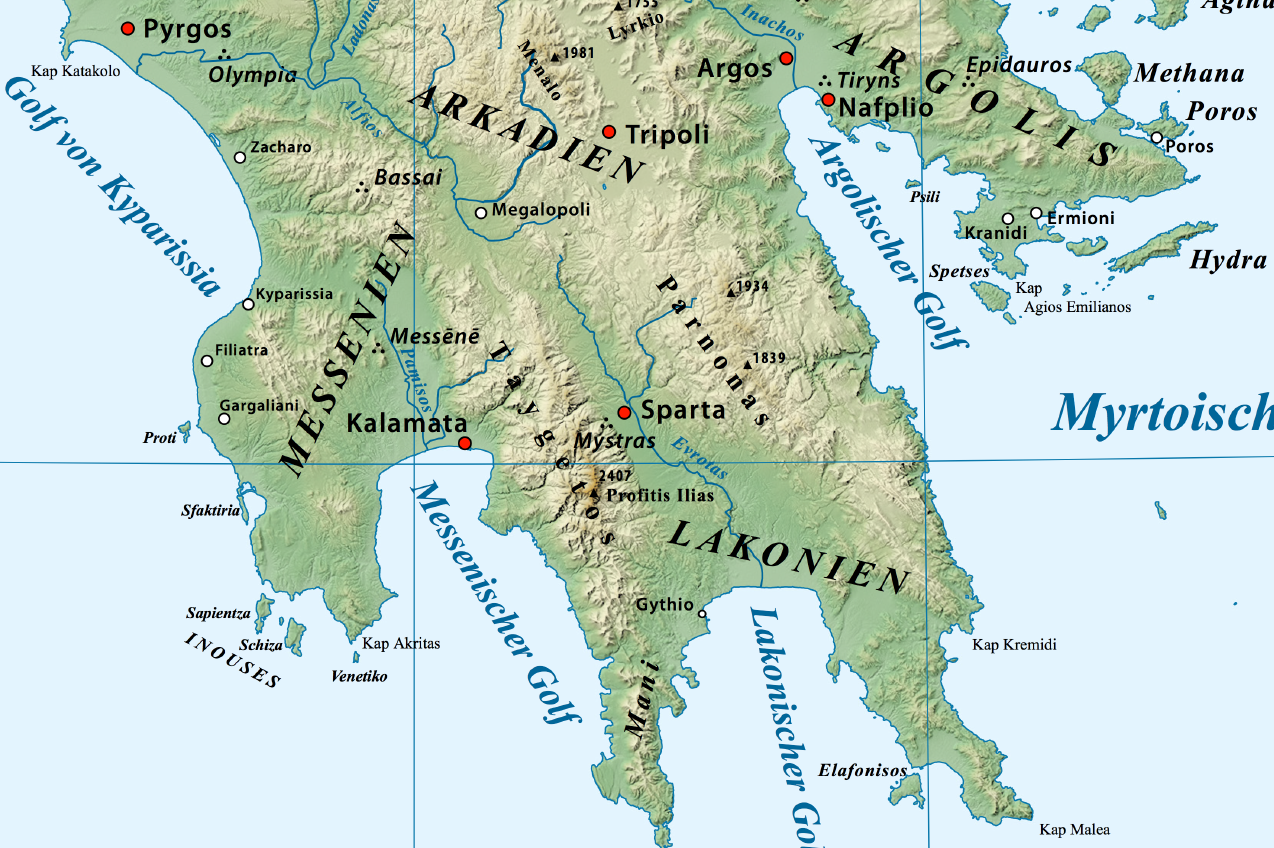
Parnon or Parnonas ( el, Πάρνων/Πάρνωνας) or Malevos (Μαλεβός) is a mountain range, or massif, on the east of the Laconian plain and the Evrotas valley. It is visible from Athens above the top of the Argive mountains. The western part is in the Laconia prefecture and the northeastern part is in the Arcadia prefecture. The Parnon range separates Laconia from Arcadia. Its summit offers panoramic views of southeastern Arcadia and South Kynouria and much of Laconia that includes the northern and the central portions and reaches as far as the Taygetos mountains. It also views a part of the central Arcadia and the southern Argolis prefectures. It views the Myrtoan and the Laconian Gulfs. Geography Physical The Parnon Massif is divided into three parts.Unless otherwise cited this section relies heavily on The northernmost, which is the highest, runs from just north of Ano Doliana in North Kynouria, eastern Arcadia, southeast to Platanaki Pass. Platanaki, ancie ... [...More Info...] [...Related Items...] OR: [Wikipedia] [Google] [Baidu] |
Greece
Greece,, or , romanized: ', officially the Hellenic Republic, is a country in Southeast Europe. It is situated on the southern tip of the Balkans, and is located at the crossroads of Europe, Asia, and Africa. Greece shares land borders with Albania to the northwest, North Macedonia and Bulgaria to the north, and Turkey to the northeast. The Aegean Sea lies to the east of the Geography of Greece, mainland, the Ionian Sea to the west, and the Sea of Crete and the Mediterranean Sea to the south. Greece has the longest coastline on the Mediterranean Basin, featuring List of islands of Greece, thousands of islands. The country consists of nine Geographic regions of Greece, traditional geographic regions, and has a population of approximately 10.4 million. Athens is the nation's capital and List of cities and towns in Greece, largest city, followed by Thessaloniki and Patras. Greece is considered the cradle of Western culture, Western civilization, being the birthplace of Athenian ... [...More Info...] [...Related Items...] OR: [Wikipedia] [Google] [Baidu] |
Therapnes
Therapnes ( el, Θεράπνες) is a municipal unit (''dimotiki enotita'') of the municipality (''dimos'') of Sparti within the regional unit (''perifereiaki enotita'') of Laconia in the region (''perifereia'') of Peloponnese, one of 13 regions into which Greece has been divided. The municipal unit has an area of 261.711 km2. Before 2011 Therapnes was a Demos of Lakonia according to Law 2539 of 1997, the Kapodistria Plan. Its seat was Gkoritsa, which now has no such status. Within its borders lies the ancient town of Therapne. Both before the Kallikratis law and after it, Therapnes was composed of the same eight Local Communities (''topiki koinotita''), the lowest level of the hierarchy: Agioi Anargyroi (formerly Zouraina), Agrianoi, Gkoritsa, Kalloni, Kefalas, Platana, Skoura and Chrysafa. The population of Therapnes in the 2011 census, conducted by the Ministry of the Interior, was 2,304. Villages *Goritsa or Gortsoupolis, as it is called by the Athenian residents of Gor ... [...More Info...] [...Related Items...] OR: [Wikipedia] [Google] [Baidu] |
Limestone
Limestone ( calcium carbonate ) is a type of carbonate sedimentary rock which is the main source of the material lime. It is composed mostly of the minerals calcite and aragonite, which are different crystal forms of . Limestone forms when these minerals precipitate out of water containing dissolved calcium. This can take place through both biological and nonbiological processes, though biological processes, such as the accumulation of corals and shells in the sea, have likely been more important for the last 540 million years. Limestone often contains fossils which provide scientists with information on ancient environments and on the evolution of life. About 20% to 25% of sedimentary rock is carbonate rock, and most of this is limestone. The remaining carbonate rock is mostly dolomite, a closely related rock, which contains a high percentage of the mineral dolomite, . ''Magnesian limestone'' is an obsolete and poorly-defined term used variously for dolomite, for limes ... [...More Info...] [...Related Items...] OR: [Wikipedia] [Google] [Baidu] |
Geraki, Laconia
Geronthres ( el, Γερόνθρες), named after ancient Geronthrae, is a former municipality in Laconia, Peloponnese, Greece. Since the 2011 local government reform it is part of the municipality Evrotas, of which it is a municipal unit. The municipal unit has an area of 236.780 km2. The seat of administration was the village Geraki. The municipal population is approx. 1,800. Dutch excavations (University of Amsterdam) point to first settlement of the acropolis hill in the (Final) Neolithic period. In the Early Helladic period the site must have contained an administrative centre of some kind, judged by the sealing fragments that can be compared by those found in Lerna. Habitation continued towards the end of the Middle Helladic period, but no Mycenaean finds have been found yet. First signs of renewed habitation date from the Iron Age. The site is left again in the Roman period. Close to Geraki is the medieval fortress after which the village is named, and which formed ... [...More Info...] [...Related Items...] OR: [Wikipedia] [Google] [Baidu] |
Kosmas, Greece
Kosmas ( el, Κοσμάς) is a mountain village and a former community in Arcadia, Peloponnese, Greece. It is considered a traditional settlement. Since the 2011 local government reform it is part of the municipality South Kynouria, of which it is a municipal unit. The municipal unit has an area of 85.220 km2. In 2011 its population was 362. Kosmas is situated in the southeastern part of the Parnon mountains, at about 1150 m elevation, on the road from Skala ( Laconia) to Leonidio. It is 13 km southwest of Leonidio, 28 km east of Sparti, 28 km northeast of Skala, 35 km south of Argos and 57 km southeast of Tripoli. Kosmas has a school, a church and a library. Population History In the area which is now known as Kosmas was the ancient city of Selinous, which had a temple of Apollo. Kosmas was first mentioned in 1592 in a letter of Gennadios, metropolitan of Monemvasia. Many inhabitants of Kosmas participated in the Greek War of Independence ... [...More Info...] [...Related Items...] OR: [Wikipedia] [Google] [Baidu] |
Agios Vasileios, Arcadia
''Agios'' ( el, Άγιος), plural ''Agioi'' (), transcribes masculine gender Greek words meaning 'sacred' or 'saint' (for example Agios Dimitrios, Agioi Anargyroi). It is frequently shortened in colloquial language to ''Ai'' (for example Ai Stratis). In polytonic script it is written ''Hagios'' () (for example Hagios Demetrios). It is also transliterated as, inter alia, ''Haghios'', ''Ayios'', ''Aghios'' (for example Ayios Dhometios, Aghios Andreas Beach, respectively) in the singular form, and ''Haghioi'', ''Ayioi'', ''Aghioi'', ''Ayii'' in the plural (for example Ayioi Omoloyites, Nicosia, Aghioi Theodoroi, Ayii Trimithias respectively). The feminine is ''agia'', ''ayia'', ''aghia'', ''hagia'' or ''haghia'' (Greek: or in polytonic form ), for example ''Agia Varvara'' (Saint Barbara). See also * * Agia (other), the feminine form of the word in Greek * Agis (other) * Agii (other) * Agius, a surname * ''Agos'', an Armenian newspaper * Agoi, a clan a ... [...More Info...] [...Related Items...] OR: [Wikipedia] [Google] [Baidu] |
Kastanitsa
Kastanitsa ( el, Καστάνιτσα, Tsakonian: Γαστένιτσα) is a village in Arcadia in Greece, on the southern slope of Mount Parnon. It is considered a traditional settlement. It is noted for its production of chestnuts, from which it takes its name, and for formerly being a majority Tsakonian-speaking settlement. History Kastanitsa is first mentioned in writing in 1293, but the settlement is thought to be nearly two centuries older, founded by Tsakones fleeing the rule of Slavic tribes that had invaded the Peloponnese. According to Kastaniot tradition, the village was founded by two families called Pentalonas and Bezenikos. A Byzantine fort called ''Koutoupou'' was placed on the nearby hill of ''Pyrgos'' while the restored Byzantine monarchy warred with the Frankish lords of the Peloponnese to recover territory lost in the wake of the Fourth Crusade. Further documentary evidence is scant until the eighteenth century. In 1788, a French traveller named Villehouso ... [...More Info...] [...Related Items...] OR: [Wikipedia] [Google] [Baidu] |
Agios Petros, Arcadia
Agios Petros ( el, Άγιος Πέτρος) is a mountain village and a community in the municipality of North Kynouria in southeastern Arcadia, Greece. It is considered a traditional settlement. In 2011 its population was 675 for the village and 717 for the community, which includes the village Xirokampi and the Malevi monastery. It is situated in the northern part of the Parnon mountains, at about 950 m elevation. It is 3 km south of Elatos, 5 km east of Vourvoura, 6 km northeast of Karyes ( Laconia), 18 km southwest of Astros and 26 km southeast of Tripoli. Population Notable people * Nilus the Myrrh-streamer (1601–1651), an Orthodox Christian saint and ascetic See also * List of settlements in Arcadia *List of traditional settlements of Greece Traditional settlements in Greece are considered those settlements that have retained their unchanged image of the past, as well as their local character. The traditional settlements designated by law in Greece exceed 800. Ar ... [...More Info...] [...Related Items...] OR: [Wikipedia] [Google] [Baidu] |


