|
Mount Nijō
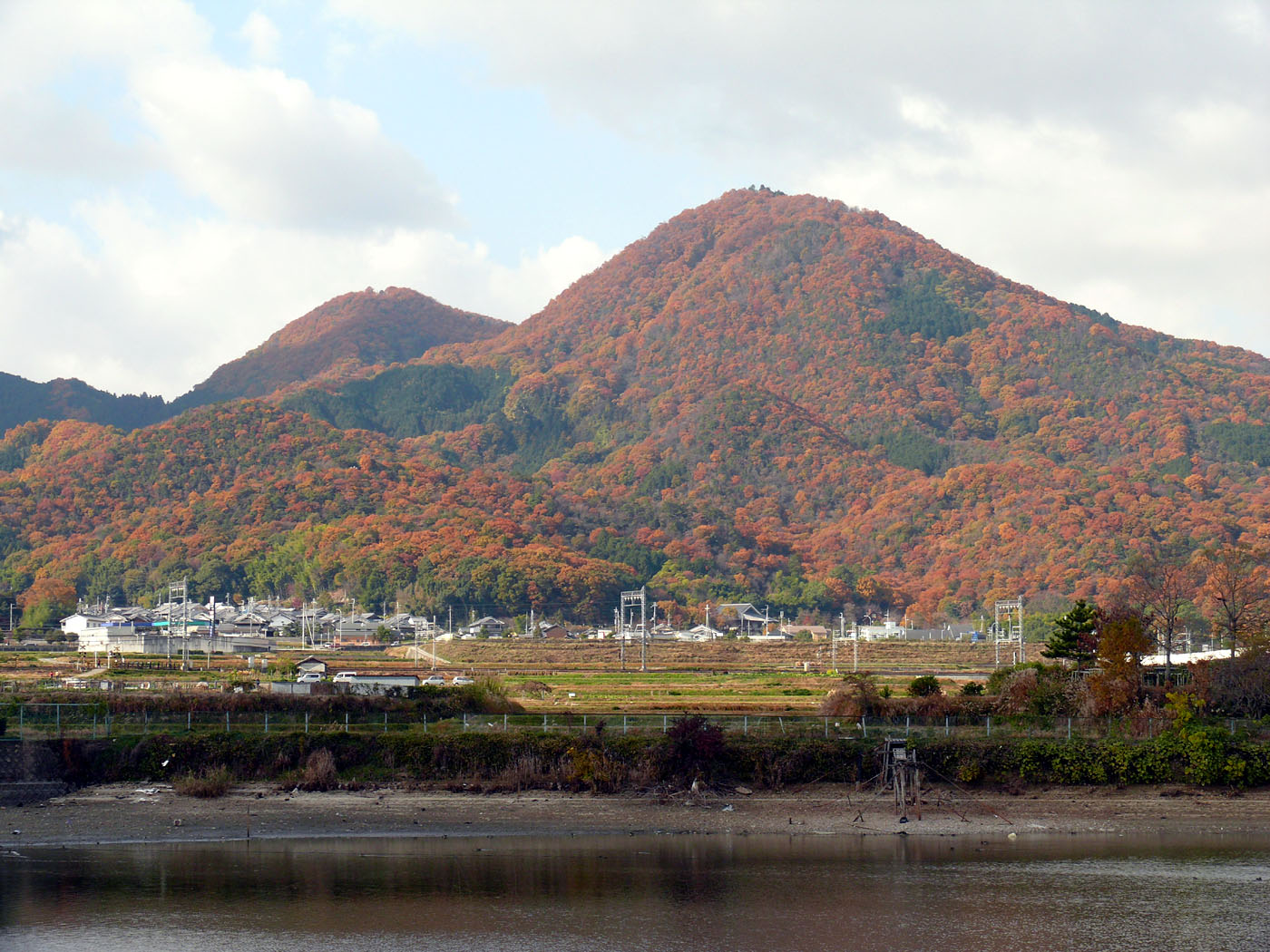
Mount Nijō(二上山, Nijōzan) is a mountain in the Kongō Range straddling the prefectural border between Taishi, Osaka and Katsuragi, Nara in Japan. Mount Nijō has twin peaks, Odake (517m) and Medake (474m). From the top there are sweeping views of Nara’s basin, Osaka plain and Osaka bay. Mount Nijō is located along the Minami Osaka Line of the Kintetsu Railway and is accessible on several different hiking trails on all sides of varying difficulty and length. The mountain forms part of the diamond trail, which is a 45 km-long trail running along the Kongō mountain range separating Nara, Osaka and Wakayama Prefectures. Heading south along the diamond trail is Mount Yamato Katsuragi (about 8.6 km) and Mount Kongō (about 14.1 km). According to the Man'yōshū, Mount Nijō was known as ''‘Futakamiyama’'' which means twin mountains. This mountain is worshipped by local people as a gateway to heaven. Mt Nijō was an active volcano millions of years ago. ... [...More Info...] [...Related Items...] OR: [Wikipedia] [Google] [Baidu] |
Kongō Range
The is a mountain range on the borders of Nara and Osaka Prefectures on the island of Honshū in the southwest of central Japan. The range separates the Osaka Plain and the Nara Basin, and forms a natural place for the boundary between the prefectures. The primary mountain in the range is Mount Kongō, and is contained within the Kongō-Ikoma-Kisen Quasi-National Park. Geography The Kongō Range is about long, from the Yamato River in the north to the Kino River in the south. East to West, it averages about wide. The mountains in the range are from to in elevation. At Chihaya Pass, the ridgeline turns west and the Izumi Mountains begin at that point. They stretch along the border between Osaka and Wakayama Prefectures. Mountains in the range Listed in order of elevation. *Mount Kongō, *Mount Yamato Katsuragi, * Iwahashi Mountain, *Mount Nijō has two peaks: ** Odake, ** Medake, * Myōjin Mountain, Gallery File:Kongo-zakura4.jpg, Kongō cherry blossoms in spring Fi ... [...More Info...] [...Related Items...] OR: [Wikipedia] [Google] [Baidu] |
Sanukitoid
{{No footnotes, date=December 2021 Sanukitoids are a variety of high-Mg granitoid found in convergent margin settings. The term "sanukitoid" was originally used to define a variety of Archean plutonic rock, but now also includes younger rocks with similar geochemical characteristics (Shirey & Hanson 1984; Rogers et al. 1985; Stern et al. 1989; Kelemen et al. 2004). They are called "sanukitoid" because of their similarity in bulk chemical composition to high-magnesium andesite from the Setouchi Peninsula of Japan, known as "sanukites" or "setouchites" (Tatsumi and Ishizaki 1982). Sanukite rocks are an andesite characterized by orthopyroxene as the mafic mineral, andesine as the plagioclase, and a glassy groundmass. Rocks formed by processes similar to those of sanukite may have compositions outside the sanukitoid field. The term was originally defined by Stern et al. (1989) to refer to plutonic rocks containing between 55 and 60 weight percent SiO2, with Mg# >0.6, Ni >100 ppm, Cr > ... [...More Info...] [...Related Items...] OR: [Wikipedia] [Google] [Baidu] |
Taima-dera
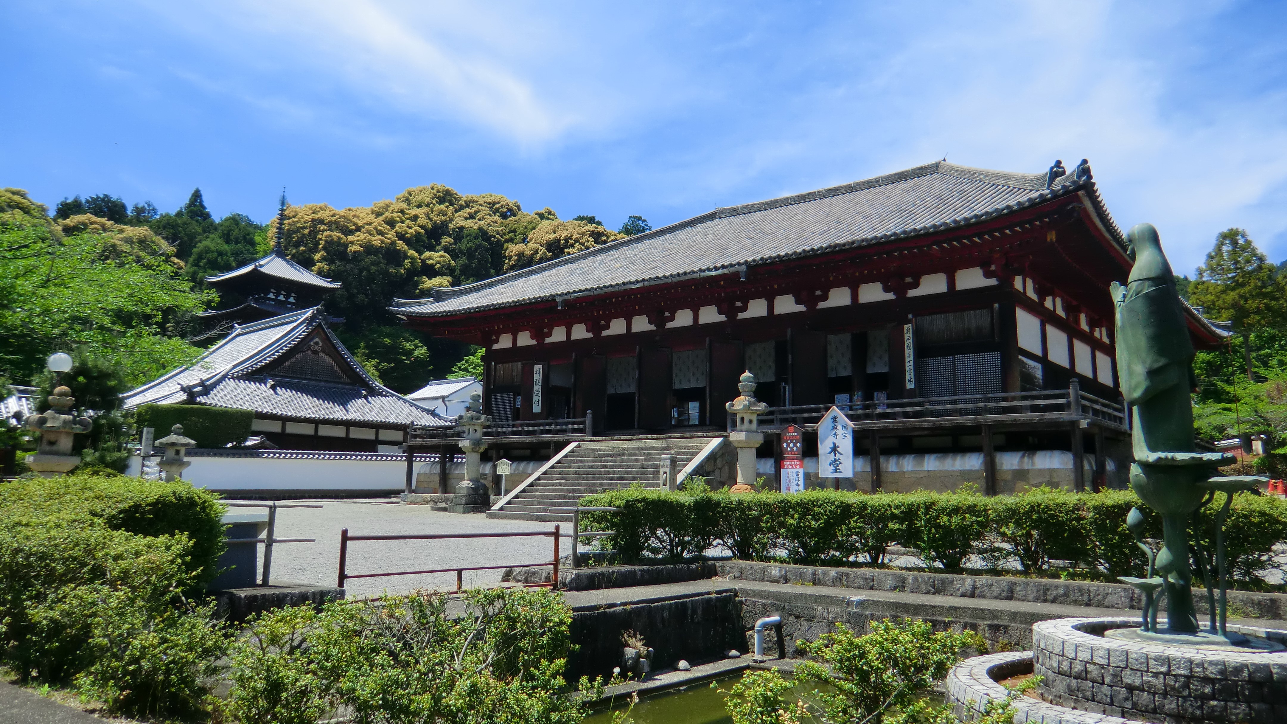
''Taima-dera'' (當麻寺) is a Buddhist temple in Katsuragi, Nara, Japan. The temple legend says it was built originally in 612 by the Imperial Prince Maroko, the brother of Prince Shotoku. The temple was moved to its present location in 681 by the grandson of Prince Maroko, and served as the head temple, or ''honzan'' (本山) of the Hosso sect although currently the temple is jointly administrated by Shingon Buddhism, Shingon and Jōdo-shū, Jodo schools. The temple's main object of veneration is maitreya, Maitreya Bodhisattva, but the most popular attraction is the Taima Mandala, a graphical representation of the Sukhavati, Sukhavati Pure Land, and pilgrimage site for Pure Land Buddhists. It is believed that the Taima Mandala was woven in one day by Chūjō-hime, Princess Chujo-hime. Architecture Taima-dera is the only temple in Japan to have its original twin pagodas intact, which date from around AD 710. The surrounding gardens are renowned for peonies in May and a large ... [...More Info...] [...Related Items...] OR: [Wikipedia] [Google] [Baidu] |
Taimadera Station
is a railway station in Katsuragi, Nara Prefecture, Japan. Line *Kintetsu Minami Osaka Line Layout Taimadera Station has two four-car length side platforms serving a track each. The entrance is located in the south-east side of Abenobashi-bound platform and the platforms are connected by train crossings. Platforms Surroundings * Taima-dera - sightseeing spot for peony The peony or paeony is a flowering plant in the genus ''Paeonia'' , the only genus in the family Paeoniaceae . Peonies are native to Asia, Europe and Western North America. Scientists differ on the number of species that can be distinguished, ... * Katsuragi City Hall Taima Office (former Taima Town Office) * Katsuragi City Sumo Museum Kehayaza File:Taima dera-from miharashidai.jpg, Taima-dera West Pagoda (back) East pagoda (back) File:Katsuragishi sumokan.jpg, Katsuragi City Sumo Museum Kehayaza Adjacent stations Express trains stop at this station and adjacent Nijō-jinjaguchi Station duri ... [...More Info...] [...Related Items...] OR: [Wikipedia] [Google] [Baidu] |
Nijōzan Station
is a railway station in Kashiba, Nara Prefecture, Japan. Line *Kintetsu Railway :*Minami Osaka Line is a railway line operated by Kintetsu Railway connecting in Osaka and in Kashihara, Nara Prefecture via Osaka's southern suburb cities of Matsubara, Fujiidera and Habikino in Osaka Prefecture, and Katsuragi and Yamato-Takada in Nara Pref ... Layout The station has two side platforms and two tracks Surroundings * Mount Nijō * Donzurubō * Kintetsu Nijō Station Adjacent stations Railway stations in Japan opened in 1929 Railway stations in Nara Prefecture {{Nara-railstation-stub ... [...More Info...] [...Related Items...] OR: [Wikipedia] [Google] [Baidu] |
Nijō Station (Nara)
is a railway station in Kashiba, Nara Prefecture, Japan. Line *Kintetsu Railway **Osaka Line is a designated city in the Kansai region of Honshu in Japan. It is the capital of and most populous city in Osaka Prefecture, and the third most populous city in Japan, following Special wards of Tokyo and Yokohama. With a population of 2.7 ... Layout The station has two side platforms on the ground, serving one track each. Train schedules Suburban semi-Express and local meet 4/h stopped at noon. Adjacent stations External links *Nijō Station page from K's Plaza Railway stations in Nara Prefecture {{Nara-railstation-stub ... [...More Info...] [...Related Items...] OR: [Wikipedia] [Google] [Baidu] |
Sekiya Station (Nara)
is a railway station in Kashiba, Nara Prefecture, Japan. It is on the Osaka Line operated by the Kintetsu Railway. Layout Sekiya Station has two side platforms A side platform (also known as a marginal platform or a single-face platform) is a platform positioned to the side of one or more railway tracks or guideways at a railway station, tram stop, or transitway. A station having dual side platforms ... serving two tracks. Platforms Adjacent stations Railway stations in Nara Prefecture {{Nara-railstation-stub ... [...More Info...] [...Related Items...] OR: [Wikipedia] [Google] [Baidu] |
Kaminotaishi Station
is a passenger railway station in located in the city of Habikino, Osaka Prefecture, Japan, operated by the private railway operator Kintetsu Railway. The station is also the nearest station to the town of Taishi where no train station is located. Lines Kaminotaishi Station is served by the Minami Osaka Line, and is located 22.0 rail kilometers from the starting point of the line at Ōsaka Abenobashi Station. Station layout The station was consists of two opposed side platforms connected by a level crossing Platforms Adjacent stations Express trains stop at this station on weekends and national holidays in October and November every year for Mikan-gari or Mandarin orange eating. History Kaminotaishi Station opened on March 29, 1929. Passenger statistics In fiscal 2018, the station was used by an average of 4,528 passengers daily. Surrounding area *Eifuku-ji (Kami no Taishi) *Saiho-in *Tomb of Ono no Imoko *Tsuboi Hachiman Shrine *Kaminotaishi Mikan Field See a ... [...More Info...] [...Related Items...] OR: [Wikipedia] [Google] [Baidu] |
Emery (rock)
Emery, or corundite, is a dark granular rock used to make abrasive powder. It largely consists of corundum ( aluminium oxide), mixed with other minerals such as the iron-bearing spinels, hercynite, and magnetite, and also rutile ( titania). Industrial emery may contain a variety of other minerals and synthetic compounds such as magnesia, mullite, and silica. It is black or dark grey in colour, less dense than translucent-brown corundum with a specific gravity of between 3.5 and 3.8. Because it can be a mixture of minerals, no definite Mohs hardness can be assigned: the hardness of corundum is 9 and that of some spinel-group minerals is near 8, but the hardness of others such as magnetite is near 6. Crushed or naturally eroded emery (known as ''black sand'') is used as an abrasive—for example, on emery boards and emery cloth. It is also used as a traction enhancer in asphalt and tarmac mixtures. Turkey and Greece are the main suppliers of the world's emery. These two countr ... [...More Info...] [...Related Items...] OR: [Wikipedia] [Google] [Baidu] |
Tuff
Tuff is a type of rock made of volcanic ash ejected from a vent during a volcanic eruption. Following ejection and deposition, the ash is lithified into a solid rock. Rock that contains greater than 75% ash is considered tuff, while rock containing 25% to 75% ash is described as tuffaceous (for example, ''tuffaceous sandstone''). Tuff composed of sandy volcanic material can be referred to as volcanic sandstone. Tuff is a relatively soft rock, so it has been used for construction since ancient times. Because it is common in Italy, the Romans used it often for construction. The Rapa Nui people used it to make most of the ''moai'' statues on Easter Island. Tuff can be classified as either igneous or sedimentary rock. It is usually studied in the context of igneous petrology, although it is sometimes described using sedimentological terms. Tuff is often erroneously called tufa in guidebooks and in television programmes. Volcanic ash The material that is expelled in a volcanic ... [...More Info...] [...Related Items...] OR: [Wikipedia] [Google] [Baidu] |
Igneous Rock
Igneous rock (derived from the Latin word ''ignis'' meaning fire), or magmatic rock, is one of the three main The three types of rocks, rock types, the others being Sedimentary rock, sedimentary and metamorphic rock, metamorphic. Igneous rock is formed through the cooling and solidification of magma or lava. The magma can be derived from Partial melting, partial melts of existing rocks in either a Terrestrial planet, planet's mantle (geology), mantle or crust (geology), crust. Typically, the melting is caused by one or more of three processes: an increase in temperature, a decrease in pressure, or a change in composition. Solidification into rock occurs either below the surface as intrusive rocks or on the surface as extrusive (geology), extrusive rocks. Igneous rock may form with crystallization to form granular, crystalline rocks, or without crystallization to form Volcanic glass, natural glasses. Igneous rocks occur in a wide range of geological settings: shields, platforms ... [...More Info...] [...Related Items...] OR: [Wikipedia] [Google] [Baidu] |
Taishi, Osaka
260px, Eifuku-ji Kondo 260px, Shinaga Jinja 260px, Grave of Emperor Yōmei is a town located in Minamikawachi District, Osaka Prefecture, Japan. , the town had an estimated population of 13,172 in 5572 households and a population density of 930 persons per km². The total area of the town is . Geography Taishi is located in the southeastern part of Osaka Prefecture on the west side of Kongō Range and Katsuragi Mountains which separate Osaka from Nara Prefecture. The town is dominated by the peaks of Mount Nijō to the east. Neighboring municipalities Osaka Prefecture * Habikino * Tondabayashi * Kanan Nara Prefecture * Kashiba * Katsuragi Climate Taishi has a Humid subtropical climate (Köppen ''Cfa'') characterized by warm summers and cool winters with light to no snowfall. The average annual temperature in Taishi is 14.2 °C. The average annual rainfall is 1636 mm with September as the wettest month. The temperatures are highest on average in August, at ... [...More Info...] [...Related Items...] OR: [Wikipedia] [Google] [Baidu] |


.png)