Monumental Island
   HOME
*


Monumental Island
Monumental Island ( iu, ᐅᒥᐊᙳᐊᖅ, Umiannguaq) is a Baffin Island offshore island located in the Arctic Archipelago in the territory of Nunavut. The island lies in Davis Strait, almost halfway between Lady Franklin Island and Little Hall Island. Monumental Island was named by Charles Francis Hall, an Arctic explorer, as a tribute to the memory of Sir John Franklin Sir John Franklin (16 April 1786 – 11 June 1847) was a British Royal Navy officer and Arctic explorer. After serving in wars against Napoleonic France and the United States, he led two expeditions into the Canadian Arctic and through .... References External links Photos Islands of Davis Strait Uninhabited islands of Qikiqtaaluk Region Islands of Baffin Island {{QikiqtaalukNU-geo-stub ...
[...More Info...]      
[...Related Items...]     OR:     [Wikipedia]   [Google]   [Baidu]  


picture info

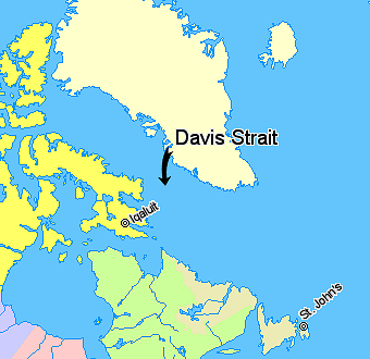
Davis Strait
Davis Strait is a northern arm of the Atlantic Ocean that lies north of the Labrador Sea. It lies between mid-western Greenland and Baffin Island in Nunavut, Canada. To the north is Baffin Bay. The strait was named for the English explorer John Davis (1550–1605), who explored the area while seeking a Northwest Passage. By the 1650s it was used for whale hunting. Extent The International Hydrographic Organization defines the limits of the Davis Strait as follows: ''On the North.'' The Southern limit of Baffin Bay 70° North between Greenland and Baffin Island">Baffin Land]. ''On the East.'' The Southwest coast of Greenland. ''On the South.'' The parallel of 60th parallel north, 60° North between Greenland and Labrador. ''On the West.'' The Eastern limit of the Northwestern Passages South of 70° North he East coast of Baffin Island to East Bluff, its Southeastern extremityand of Hudson Strait line from East Bluff, the Southeast extreme of Baffin Island (), to Point ...
[...More Info...]      
[...Related Items...]     OR:     [Wikipedia]   [Google]   [Baidu]  


picture info

Arctic Archipelago
The Arctic Archipelago, also known as the Canadian Arctic Archipelago, is an archipelago lying to the north of the Canadian continental mainland, excluding Greenland (an autonomous territory of Denmark). Situated in the northern extremity of North America and covering about , this group of 36,563 islands, surrounded by the Arctic Ocean, comprises much of Northern Canada, predominately Nunavut and the Northwest Territories. The archipelago is showing some effects of climate change, with some computer estimates determining that melting there will contribute to the rise in sea levels by 2100. History Around 2500 BCE, the first humans, the Paleo-Eskimos, arrived in the archipelago from the Canadian mainland. Between 1000–1500 CE, they were replaced by the Thule people, who are the ancestors of today's Inuit. British claims on the islands, the British Arctic Territories, were based on the explorations in the 1570s by Martin Frobisher. Canadian sovereignty was originally (187 ...
[...More Info...]      
[...Related Items...]     OR:     [Wikipedia]   [Google]   [Baidu]  


picture info

Provinces And Territories Of Canada
Within the geographical areas of Canada, the ten provinces and three territories are sub-national administrative divisions under the jurisdiction of the Canadian Constitution. In the 1867 Canadian Confederation, three provinces of British North America—New Brunswick, Nova Scotia, and the Province of Canada (which upon Confederation was divided into Ontario and Quebec)—united to form a federation, becoming a fully independent country over the next century. Over its history, Canada's international borders have changed several times as it has added territories and provinces, making it the world's second-largest country by area. The major difference between a Canadian province and a territory is that provinces receive their power and authority from the ''Constitution Act, 1867'' (formerly called the ''British North America Act, 1867''), whereas territorial governments are creatures of statute with powers delegated to them by the Parliament of Canada. The powers flowing from t ...
[...More Info...]      
[...Related Items...]     OR:     [Wikipedia]   [Google]   [Baidu]  


picture info

Nunavut
Nunavut ( , ; iu, ᓄᓇᕗᑦ , ; ) is the largest and northernmost Provinces and territories of Canada#Territories, territory of Canada. It was separated officially from the Northwest Territories on April 1, 1999, via the ''Nunavut Act'' and the ''Nunavut Land Claims Agreement, Nunavut Land Claims Agreement Act'', which provided this territory to the Inuit for independent government. The boundaries had been drawn in 1993. The creation of Nunavut resulted in the territorial evolution of Canada, first major change to Canada's political map in half a century since the province of Newfoundland and Labrador, Newfoundland was admitted in 1949. Nunavut comprises a major portion of Northern Canada and most of the Arctic Archipelago. Its vast territory makes it the list of the largest country subdivisions by area, fifth-largest country subdivision in the world, as well as North America's second-largest (after Greenland). The capital Iqaluit (formerly Frobisher Bay), on Baffin Islan ...
[...More Info...]      
[...Related Items...]     OR:     [Wikipedia]   [Google]   [Baidu]  


picture info

Regions Of Nunavut
The Canadian territory of Nunavut, which was established in 1999 from the Northwest Territories by the 1993 Nunavut Land Claims Agreement, is divided into three regions. Though these regions have no governments of their own, Nunavut's territorial government services are highly decentralized on a regional basis.. In addition, these regions serve as census divisions for Statistics Canada (though the Qikiqtaaluk and Kivalliq regions are known as the "Baffin Region" and the "Keewatin Region" to the agency). It is a misconception that Nunavut's regions constitute the former regions of the Northwest Territories (NWT), separated in their entirety. This is not the case, rather, the portions of the regions of the Northwest Territories that ended up in the newly created territory were retained and had their borders slightly adjusted upon the creation of Nunavut. The regional divisions are distinct from the district system of dividing the Northwest Territories that dated to 1876 and wa ...
[...More Info...]      
[...Related Items...]     OR:     [Wikipedia]   [Google]   [Baidu]  


picture info

Qikiqtaaluk Region
The Qikiqtaaluk Region, Qikiqtani Region (Inuktitut syllabics: ᕿᑭᖅᑖᓗᒃ ) or Baffin Region is the easternmost, northernmost, and southernmost administrative region of Nunavut, Canada. Qikiqtaaluk is the traditional Inuktitut name for Baffin Island. Although the Qikiqtaaluk Region is the most commonly used name in official contexts, several notable public organizations, including Statistics Canada prefer the older term Baffin Region. With a population of 18,988 and an area of , it is the largest and most populated of the three regions. The region consists of Baffin Island, the Belcher Islands, Akimiski Island, Mansel Island, Prince Charles Island, Bylot Island, Devon Island, Baillie-Hamilton Island, Cornwallis Island, Bathurst Island, Amund Ringnes Island, Ellef Ringnes Island, Axel Heiberg Island, Ellesmere Island, the Melville Peninsula, the eastern part of Melville Island, and the northern parts of both Prince of Wales Island and Somerset Island, plus s ...
[...More Info...]      
[...Related Items...]     OR:     [Wikipedia]   [Google]   [Baidu]  


picture info

Baffin Island
Baffin Island (formerly Baffin Land), in the Canadian territory of Nunavut, is the largest island in Canada and the fifth-largest island in the world. Its area is , slightly larger than Spain; its population was 13,039 as of the 2021 Canadian census; and it is located at . It also contains the city of Iqaluit, the capital of Nunavut. Name The Inuktitut name for the island is , which means "very big island" ( "island" + "very big") and in Inuktitut syllabics is written as . This name is used for the administrative region the island is part of ( Qikiqtaaluk Region), as well as in multiple places in Nunavut and the Northwest Territories, such as some smaller islands: Qikiqtaaluk in Baffin Bay and Qikiqtaaluk in Foxe Basin. Norse explorers referred to it as ("stone land"). In 1576, English seaman Martin Frobisher made landfall on the island, naming it "Queen Elizabeth's Foreland" and Frobisher Bay is named after him. The island is named after English explorer William Baff ...
[...More Info...]      
[...Related Items...]     OR:     [Wikipedia]   [Google]   [Baidu]  


Lady Franklin Island
Lady Franklin Island (Inuktitut: Kitigtung), is an uninhabited Baffin Island offshore island located in the Arctic Archipelago in the territory of Nunavut. The island lies in Davis Strait, from Hall Peninsula. There are at least seven smaller, unnamed islands off its northwest shore. It was named by Arctic explorer Charles Francis Hall as a tribute to Sir John Franklin's wife Lady Franklin. The island offers an abundance of bears, caribou (''tuktoo''), ducks, seals, and walrus. References External links PhotosLady Franklin Islandin the Atlas of Canada The Atlas of Canada (french: L'Atlas du Canada) is an online atlas published by Natural Resources Canada that has information on every city, town, village, and hamlet in Canada. It was originally a print atlas, with its first edition being publishe ... - Toporama; Natural Resources Canada Uninhabited islands of Qikiqtaaluk Region Islands of Baffin Island {{QikiqtaalukNU-geo-stub ...
[...More Info...]      
[...Related Items...]     OR:     [Wikipedia]   [Google]   [Baidu]  


Little Hall Island
Little Hall Island (also known as: Hall Smaller Island) is a Baffin Island offshore island located in the Arctic Archipelago in the territory of Nunavut. The island lies in the Labrador Sea a few kilometers north of its confluence with Davis Strait. Other islands also in the immediate vicinity of the tip of Hall Peninsula include the Harper Islands, Lefferts Island, Bear Island, and Hudson Island Hudson Island is the southernmost island of the Family Islands group and located approximately 20 km East of Tully Heads. The Aboriginal name for this island is ''Coolah Island''. The Great Barrier Reef Marine Park Authority The Gre .... References Uninhabited islands of Qikiqtaaluk Region Islands of Baffin Island Islands of the Labrador Sea {{QikiqtaalukNU-geo-stub ...
[...More Info...]      
[...Related Items...]     OR:     [Wikipedia]   [Google]   [Baidu]  


Charles Francis Hall
Charles Francis Hall ( – November 8, 1871) was an American Arctic explorer, best known for his collection of Inuit testimony regarding the 1845 Franklin Expedition and the suspicious circumstances surrounding his death while leading the American-sponsored ''Polaris'' expedition in an attempt to be the first to reach the North Pole. The expedition was marred by insubordination, incompetence, and poor leadership. Hall returned to the ship from an exploratory sledging journey, and promptly fell ill. Before he died, he accused members of the crew—the expedition's lead scientist, Emil Bessels, in particular—of having poisoned him. An exhumation of his body in 1968 revealed that he had ingested a large quantity of arsenic in the last two weeks of his life. Early life Little is known of Hall's early life. He was born either in Rochester, New Hampshire, or in the state of Vermont before moving to Rochester at a young age, where he was apprenticed to a blacksmith at a ...
[...More Info...]      
[...Related Items...]     OR:     [Wikipedia]   [Google]   [Baidu]  


picture info

Arctic Exploration
Arctic exploration is the physical exploration of the Arctic region of the Earth. It refers to the historical period during which mankind has explored the region north of the Arctic Circle. Historical records suggest that humankind have explored the northern extremes since 325 BC, when the ancient Greek sailor Pytheas reached a frozen sea while attempting to find a source of the metal tin. Dangerous oceans and poor weather conditions often fetter explorers attempting to reach polar regions and journeying through these perils by sight, boat, and foot has proven difficult. Ancient history Indo-European Hypothesis A controversial hypothesis, often regarded as pseudohistory, sets the home of the mythical people Hyperboreans in the Arctic. The scientist and author John G. Bennett talked about it in his research paper "The Hyperborean Origin of the Indo-European Culture" (1963). The theory was originally put forth by William F. Warren, the first President of Boston University, in hi ...
[...More Info...]      
[...Related Items...]     OR:     [Wikipedia]   [Google]   [Baidu]  


picture info

John Franklin
Sir John Franklin (16 April 1786 – 11 June 1847) was a British Royal Navy officer and Arctic explorer. After serving in wars against Napoleonic France and the United States, he led two expeditions into the Canadian Arctic and through the islands of the Arctic Archipelago, in 1819 and 1825, and served as Lieutenant-Governor of Van Diemen's Land from 1839 to 1843. During his third and final expedition, an attempt to traverse the Northwest Passage in 1845, Franklin's ships became icebound off King William Island in what is now Nunavut, where he died in June 1847. The icebound ships were abandoned ten months later and the entire crew died, from causes such as starvation, hypothermia, and scurvy. Biography Early life Franklin was born in Spilsby, Lincolnshire, on , the ninth of twelve children born to Hannah Weekes and Willingham Franklin. His father was a merchant descended from a line of country gentlemen while his mother was the daughter of a farmer. One of hi ...
[...More Info...]      
[...Related Items...]     OR:     [Wikipedia]   [Google]   [Baidu]