|
Monalanong Hill
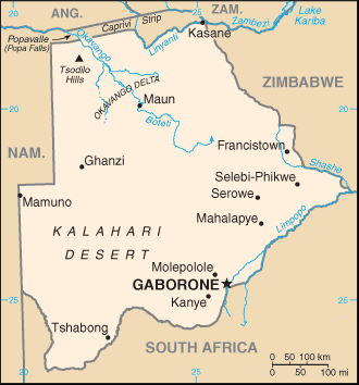
Monalanong Hill is a mountain often considered the highest point of Botswana, with an altitude derived from SRTM data of 1,494 metres (4,900 feet). The Otse Hill (at a reported altitude of 1,491 metres - 4,891 feet) or the Tsodilo Hills (at an altitude of about 1,400 metres - 4,593 feet) are also often cited as the highest point in Botswana. , World Heritage Site, accessed on April 10, 2009. References * Elevation data supplied by theShuttle Radar Topography Mission
The Shuttle Radar Topography Mission (SRTM) is an international research effort that obtained digital elevation models on a near-global ...
[...More Info...] [...Related Items...] OR: [Wikipedia] [Google] [Baidu] |
Botswana
Botswana (, ), officially the Republic of Botswana ( tn, Lefatshe la Botswana, label=Setswana, ), is a landlocked country in Southern Africa. Botswana is topographically flat, with approximately 70 percent of its territory being the Kalahari Desert. It is bordered by South Africa to the south and southeast, Namibia to the west and north, and Zimbabwe to the northeast. It is connected to Zambia across the short Zambezi River border by the Kazungula Bridge. A country of slightly over 2.3 million people, Botswana is one of the most sparsely populated countries in the world. About 11.6 percent of the population lives in the capital and largest city, Gaborone. Formerly one of the world's poorest countries—with a GDP per capita of about US$70 per year in the late 1960s—it has since transformed itself into an upper-middle-income country, with one of the world's fastest-growing economies. Modern-day humans first inhabited the country over 200,000 years ago. The Tswana ethnic ... [...More Info...] [...Related Items...] OR: [Wikipedia] [Google] [Baidu] |
SRTM
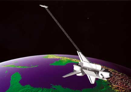
The Shuttle Radar Topography Mission (SRTM) is an international research effort that obtained digital elevation models on a near-global scale from 56°S to 60°N, to generate the most complete high-resolution digital topographic database of Earth prior to the release of the ASTER GDEM in 2009. SRTM consisted of a specially modified radar system that flew on board the Space Shuttle Endeavour during the 11-day STS-99 mission in February 2000. The radar system was based on the older '' Spaceborne Imaging Radar-C/X-band Synthetic Aperture Radar'' (SIR-C/X-SAR), previously used on the Shuttle in 1994. To acquire topographic data, the SRTM payload was outfitted with two radar antennas. One antenna was located in the Shuttle's payload bay, the other – a critical change from the SIR-C/X-SAR, allowing single-pass interferometry – on the end of a 60-meter (200-foot) mast that extended from the payload bay once the Shuttle was in space. The technique employed is known as interferomet ... [...More Info...] [...Related Items...] OR: [Wikipedia] [Google] [Baidu] |
Otse Hill
Otse Hill is a peak often cited as the highest point of Botswana, with a reported altitude of 1,491 metres (4,891 feet). It is located in the village of Otse, South-East District. Its highest cell on SRTM data is 1,486 meters - 4875 feet. The 1999 Department of Surveys and Mapping (Gaborone) 1:50,000 scale topographic map shows a "trigonometrical station" on the Otse Peak summit with an elevation of 1,491 meters - 4892 feet. The Monalanong Hill (at a SRTM-derived altitude of 1,494 metres - 4,902 feet) or the Tsodilo Hills (at an altitude of about 1400 metres - 4,593 feet) are also often given as the highest point in Botswana. , World Heritage Site, accessed on April 10, 2009. Notes See also * |
Tsodilo
The Tsodilo Hills are a UNESCO World Heritage Site (WHS), consisting of rock art, rock shelters, depressions, and caves in southern Africa. It gained its WHS listing in 2001 because of its unique religious and spiritual significance to local peoples, as well as its unique record of human settlement over many millennia. UNESCO estimates there are over 4500 rock paintings at the site. The site consists of a few main hills known as the Child Hill, Female Hill, and Male Hill. Geography There are four chief hills. The highest is 1,400 metres AMSL, one of the highest points in Botswana. The four hills are commonly described as the "Male" (the highest), "Female", "Child", plus an unnamed knoll. They are about 40 km from Shakawe and can be reached via a good graded dirt road. There is a managed campsite between the two largest hills, with showers and toilets. It is near the most famous of the San paintings at the site, the Laurens van der Post panel, after the South-African write ... [...More Info...] [...Related Items...] OR: [Wikipedia] [Google] [Baidu] |
Shuttle Radar Topography Mission
The Shuttle Radar Topography Mission (SRTM) is an international research effort that obtained digital elevation models on a near-global scale from 56°S to 60°N, to generate the most complete high-resolution digital topographic database of Earth prior to the release of the ASTER GDEM in 2009. SRTM consisted of a specially modified radar system that flew on board the Space Shuttle Endeavour during the 11-day STS-99 mission in February 2000. The radar system was based on the older '' Spaceborne Imaging Radar-C/X-band Synthetic Aperture Radar'' (SIR-C/X-SAR), previously used on the Shuttle in 1994. To acquire topographic data, the SRTM payload was outfitted with two radar antennas. One antenna was located in the Shuttle's payload bay, the other – a critical change from the SIR-C/X-SAR, allowing single-pass interferometry – on the end of a 60-meter (200-foot) mast that extended from the payload bay once the Shuttle was in space. The technique employed is known as interferomet ... [...More Info...] [...Related Items...] OR: [Wikipedia] [Google] [Baidu] |


