|
Miskin, Mountain Ash
Miskin ( cy, Meisgyn) is a village and district of the town of Mountain Ash within the Cynon Valley in Rhondda Cynon Taf, Wales. The Miskin district is part of the community of Penrhiwceiber and, for the purposes of local and national governance, is part of the electoral ward of Penrhiwceiber, along with the district of Perthcelyn. The former St Teilo's church was built c.1890 but since demolished and a meeting room, Miskin Hall, built on its site. As of 2018, Miskin Hall was empty and for sale. Geography Miskin is located south of Darranlas, north of Penrhiwceiber Penrhiwceiber is a small Welsh village and community (and electoral ward) in the county borough of Rhondda Cynon Taf that lies south of the town Aberpennar and north of the village of Tyntetown, and is one of many villages that lies within the C ..., and is the location of Miskin Primary School. References External links * {{authority control Villages in Rhondda Cynon Taf ... [...More Info...] [...Related Items...] OR: [Wikipedia] [Google] [Baidu] |
Cynon Valley (UK Parliament Constituency)
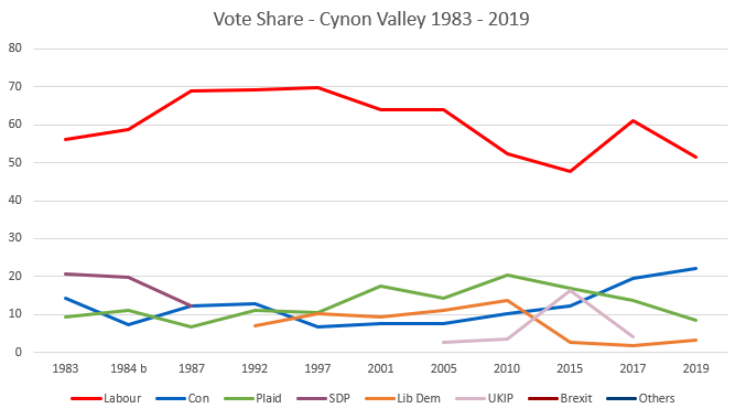
Cynon Valley ( cy, Cwm Cynon) is a constituency represented in the House of Commons of the UK Parliament since 2019 by Beth Winter of the Labour Party. The Cynon Valley Senedd constituency was created with the same boundaries in 1999 (as an Assembly constituency). Boundaries 1983–2010: The Borough of Cynon Valley. 2010–present: The Rhondda Cynon Taff County Borough electoral divisions of Aberaman North, Aberaman South, Abercynon, Aberdare East, Aberdare West/Llwydcoed, Cilfynydd, Cwmbach, Glyncoch, Hirwaun, Mountain Ash East, Mountain Ash West, Penrhiwceiber, Pen-y-waun, Rhigos, and Ynysybwl. The constituency encompasses the towns of Aberdare, Mountain Ash, Cilfynydd, Abercynon and Hirwaun. Members of Parliament Elections Elections in the 1980s * Death of Ioan Evans 10 February 1984 Elections in the 1990s Elections in the 2000s Elections in the 2010s ... [...More Info...] [...Related Items...] OR: [Wikipedia] [Google] [Baidu] |
Rhondda Cynon Taf
Rhondda Cynon Taf (; RCT; also spelt as Rhondda Cynon Taff) is a county borough in the south-east of Wales. It consists of five valleys: the Rhondda Fawr, Rhondda Fach, Cynon, Taff (Welsh: ''Taf'') and Ely valleys, plus a number of towns and villages away from the valleys. Results from the 2011 census showed 19.1% of its 234,410 residents self-identified as having some ability in the use of the Welsh language. The county borough borders Merthyr Tydfil County Borough and Caerphilly County Borough to the east, Cardiff and the Vale of Glamorgan to the south, Bridgend County Borough and Neath Port Talbot to the west and Powys to the north. Its principal towns are - Aberdare, Llantrisant with Talbot Green and Pontypridd, with other key settlements/towns being - Maerdy, Ferndale, Hirwaun, Llanharan, Mountain Ash, Porth, Tonypandy, Tonyrefail and Treorchy. The most populous individual town in Rhondda Cynon Taf is Aberdare ( cy, Aberdâr) with a population of 39,550 (2011), followed ... [...More Info...] [...Related Items...] OR: [Wikipedia] [Google] [Baidu] |
Mid Glamorgan
, Government= Mid Glamorgan County Council , Status= Non-metropolitan county (1974–1996) Preserved county (1996–) , Start= 1974 , End= 1996 , Arms= ''Coat of arms of Mid Glamorgan County Council'' , Replace= Bridgend Merthyr Tydfil Rhondda Cynon Taff Caerphilly Preserved county of Mid Glamorgan , Map= ''Mid Glamorgan shown within Wales as a preserved county'' , PopulationLast= 423,200 (est; 2003 borders) Ranked 4th , PopulationLastYear= 2007 , AreaFirst= Ranked 7th , AreaFirstYear= 2003 , AreaLast= , AreaLastYear= , Divisions= Non-metropolitan districts , DivisionsNames= 1. Cynon Valley 2. Ogwr 3. Merthyr Tydfil 4. Rhondda 5. Rhymney Valley 6. Taff-Ely , HQ = County Hall, Cathays Park, Cardiff (extraterritorial) Mid Glamorgan ( cy, Morgannwg Ganol) is a preserved county of Wales. From 1974 until 1996 ... [...More Info...] [...Related Items...] OR: [Wikipedia] [Google] [Baidu] |
Cynon Valley (National Assembly For Wales Constituency)
, constituency_type = Senedd county constituency , parl_name=Senedd, image = , image2 = , caption2 = Cynon Valley shown within the South Wales Central electoral region and the region shown within Wales , year = 1999 , member_label = MS , member = Vikki Howells , party_label = Party , party = Welsh Labour , parts_label = Preserved county , parts = Mid Glamorgan Cynon Valley ( cy, Cwm Cynon) is a constituency of the Senedd. It elects one Member of the Senedd by the first past the post method of election. It is also one of eight constituencies in the South Wales Central electoral region, which elects four additional members, in addition to eight constituency members, to produce a degree of proportional representation for the region as a whole. Boundaries The constituency was created for the first election to the Assembly, in 1999, with the name and boundaries of the ... [...More Info...] [...Related Items...] OR: [Wikipedia] [Google] [Baidu] |
Mountain Ash, Rhondda Cynon Taf
Mountain Ash ( cy, Aberpennar) is a town and former community in the Cynon Valley, within the County Borough of Rhondda Cynon Taf, Wales, with a population of 11,230 at the 2011 Census, estimated in 2019 at 11,339. It includes the districts and villages of Cefnpennar, Cwmpennar, Caegarw, Darranlas, Fernhill, Glenboi and Newtown, all within the historic county boundaries of Glamorgan. Aberdare lies about 4.5 miles (7.2 km) north-west, Cardiff 19 miles (31 km) south-east, and Penrhiwceiber a mile to the south-east. It divides into two communities (civil parishes): West covers the town centre and the districts of Miskin, Darranlas, Fernhill and Glenboi, and East the districts of Cefnpennar, Cwmpennar, Caegarw and Newtown. Etymology Before the establishment of a village in the early 19th century the landscape was identified by a variety of Welsh toponyms. The name Aberpennar ("Mouth of the river Pennar") is recorded as early as 1570 as ''Aber Pennarthe'', in 1600 as ... [...More Info...] [...Related Items...] OR: [Wikipedia] [Google] [Baidu] |
Cynon Valley
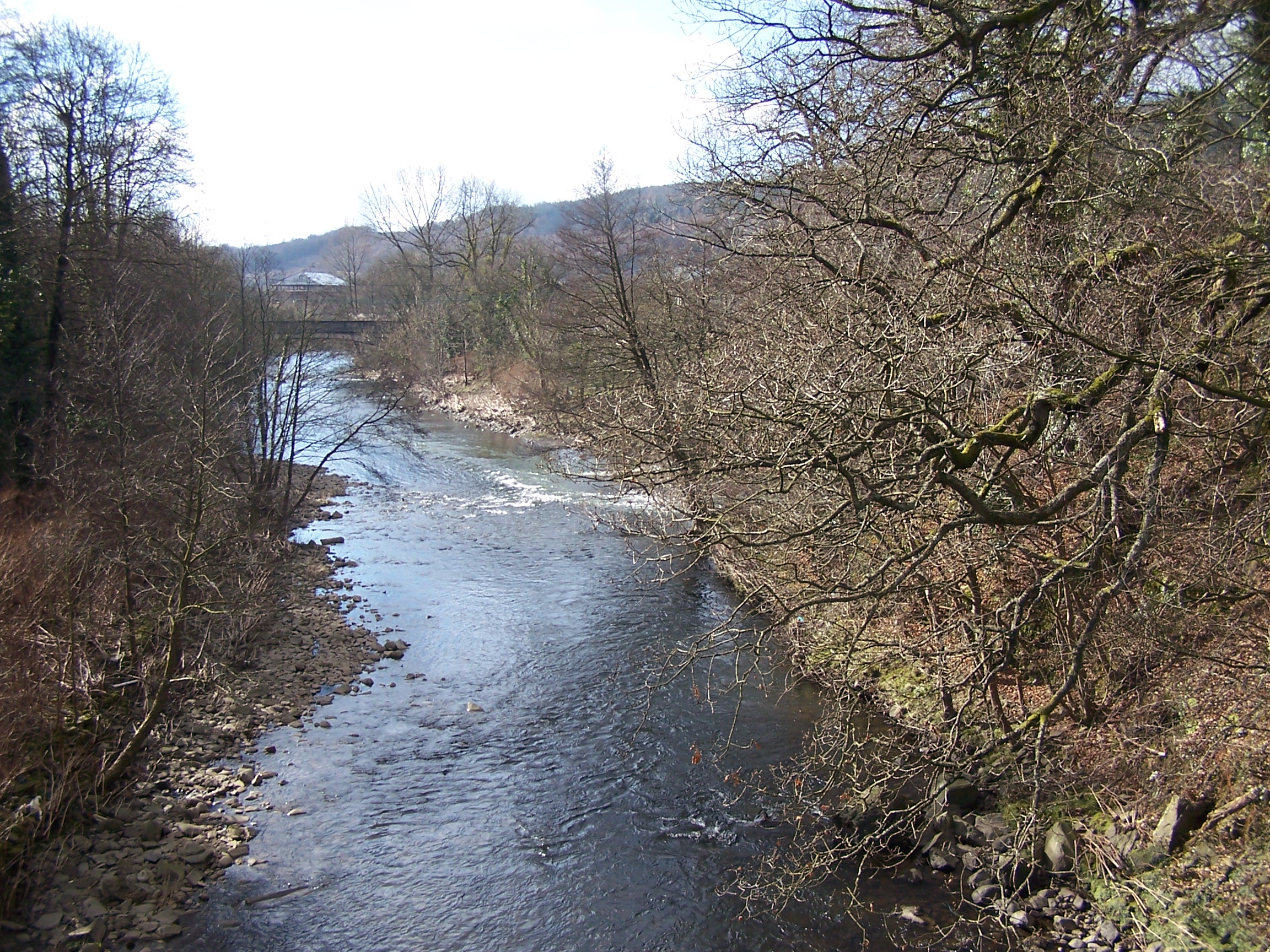
Cynon Valley () is a former coal mining valley in Wales. Cynon Valley lies between Rhondda and the Merthyr Valley and takes its name from the River Cynon. Aberdare is located in the north of the valley and Mountain Ash is in the south of the valley. From 1974 to 1996 Cynon Valley was a local government district. According to the 2001 census, the Cynon Valley has a population of 63,512. In 2001 12.1% of the inhabitants were recorded as Welsh speakers. In common with some of the other South Wales Valleys, Cynon Valley had a high percentage of Welsh speakers until the early 20th century. Former district From 1974 to 1996 the Borough of Cynon Valley was one of thirty-seven districts of Wales. The district was formed from the Aberdare and Mountain Ash urban districts, the parish of Rhigos from Neath Rural District and the parish of Penderyn from Brecknockshire. It was one of six districts of Mid Glamorgan, and in 1996 was merged into the larger unitary authority of Rhondda ... [...More Info...] [...Related Items...] OR: [Wikipedia] [Google] [Baidu] |
Community (Wales)
A community ( cy, cymuned) is a division of land in Wales that forms the lowest tier of local government in Wales. Welsh communities are analogous to civil parishes in England. There are 878 communities in Wales. History Until 1974 Wales was divided into civil parishes. These were abolished by section 20 (6) of the Local Government Act 1972, and replaced by communities by section 27 of the same Act. The principal areas of Wales are divided entirely into communities. Unlike in England, where unparished areas exist, no part of Wales is outside a community, even in urban areas. Most, but not all, communities are administered by community councils, which are equivalent to English parish councils in terms of their powers and the way they operate. Welsh community councils may call themselves town councils unilaterally and may have city status granted by the Crown. In Wales, all town councils are community councils. There are now three communities with city status: Bangor, St Asaph ... [...More Info...] [...Related Items...] OR: [Wikipedia] [Google] [Baidu] |
Penrhiwceiber
Penrhiwceiber is a small Welsh village and community (and electoral ward) in the county borough of Rhondda Cynon Taf that lies south of the town Aberpennar and north of the village of Tyntetown, and is one of many villages that lies within the Cynon Valley. Prior to 1870 the area was heavy woodland, but the opening of the Penrhiwceiber Colliery in 1878 saw its rapid expansion into a thriving village. Etymology Penrhiwceiber, according to Thomas Morgan in his 1887 publication, should be worded as ''Pen-Rhiw-Cae-Byr'' - 'Top of the hill of the little field'. Other thoughts refer to the word ''ceiber'', which means joist, beam or rafter and may suggest a place where timber was plentiful, which would certainly describe the area, which was a heavy woodland, before the coming of the coal trade. History Penrhiwceiber was once a heavily wooded area with steep sloping mountainsides up until the last 20 years of the 19th century. According to the 1871 Census Records the village of Penrh ... [...More Info...] [...Related Items...] OR: [Wikipedia] [Google] [Baidu] |
Perthcelyn
Perthcelyn is a village and district of the community between Penrhiwceiber and Mountain Ash within the Cynon Valley in the county borough of Rhondda Cynon Taf, Wales. Affectionately known as the Lost City, Perthcelyn is at the top of the valley, with views of the Lower Cynon Valley. There are walks and rural paths leading to the Cwm and Ynysbwl. Perthcelyn has two local shops, and a school which opened in 1999 and replaced the old primary school, which is now a Communities First Communities First was a Welsh Government programme aimed at reducing poverty. The programme was community focused and supported the most disadvantaged people in the most deprived areas of Wales with the aim of contributing to alleviating persisten ... office. The Community centre which opened in 1976 is currently closed and despite attempts to get this re-opened the prospects look bleak with funding an issue. Employment locally within the village comes mainly from Priory Healthcare who have a nursing ... [...More Info...] [...Related Items...] OR: [Wikipedia] [Google] [Baidu] |
Darranlas
Darranlas is a large village in Mountain Ash, Rhondda Cynon Taf in South Wales. History The houses in the area are around 100–130 years old. Before the houses were built the area of Darranlas was Glyngwyn Farm. Darrenlas primary school was built in 1907 and is located in Kingcraft Street, the school is a feeder to Mountain Ash Comprehensive School. There was another primary school in the area known as Cynon Infants but it has now closed. The local public house in the area is the Napiers arms, named after General Charles James Napier. The pub is shaped like a coffin and the reason is believed that it was once owned by an undertaker. It is also believed that the street behind the pub is called Dover Street because a number of people came to the area in the 1800s from Dover to build the streets. There are also other streets that are named after the Bruce family which is the family of Lord Aberdare such as Eva Street, Knight Street, Pamela Street, Pryce Street and Clarence Street ... [...More Info...] [...Related Items...] OR: [Wikipedia] [Google] [Baidu] |

.jpg)
