|
Minot AFS
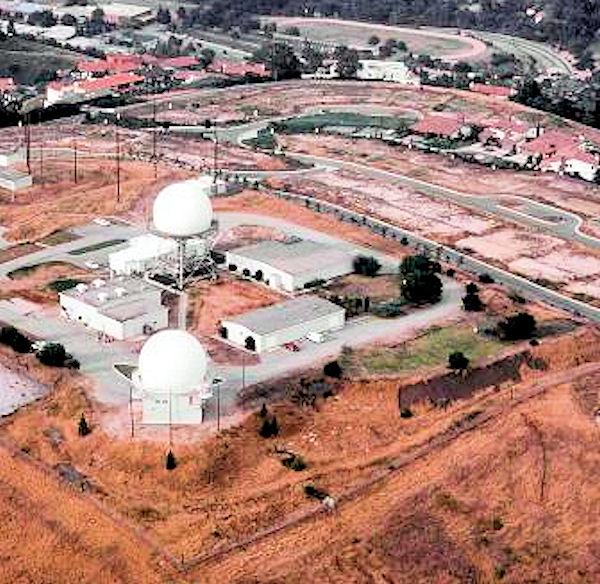
Minot Air Force Station (ADC ID: P-28 NORAD ID: Z-28) ermanent Installation Number (PIN): 1445; Installation Location Code (ILC): QJVM is a closed United States Air Force General Surveillance Radar station. It is located south of Minot, North Dakota; on the west side of US Highway 83. It was closed in 1979. A portion of the property was reopened in 1984 as the Minot Communications Site and served until 1997. Minot Air Force Station was the first major Air Force installation in North Dakota, even predating the two "large" bases, Minot Air Force Base and Grand Forks Air Force Base. History Minot Air Force Station was part of the last batch of twenty-three radar stations constructed as part of the Air Defense Command permanent network. It was activated on 20 May 1951 at Max, ND, and declared completely operational in 1952. The 786th Aircraft Control and Warning Squadron began operations with AN/FPS-3 and AN/FPS-5 radars in April 1952, and initially the station function ... [...More Info...] [...Related Items...] OR: [Wikipedia] [Google] [Baidu] |
Air Defense Command
Aerospace Defense Command was a major command (military formation), command of the United States Air Force, responsible for continental air defense. It was activated in 1968 and disbanded in 1980. Its predecessor, Air Defense Command, was established in 1946, briefly inactivated in 1950, reactivated in 1951, and then redesignated ''Aerospace'' rather than ''Air'' in 1968. Its mission was to provide air defense of the Continental United States (CONUS). It directly controlled all active measures, and was tasked to coordinate all passive means of air defense. Air defense during World War II Continental United States air defense forces during World War II were initially under the command of the four air districts – Northeast Air District, Northwest Air District, Southeast Air District, and Southwest Air District. The air districts were established on 16 January 1941, before the Pearl Harbor attack. The four air districts also handled USAAF combat training with the Army Ground F ... [...More Info...] [...Related Items...] OR: [Wikipedia] [Google] [Baidu] |
AN/FPS-90
The AN/FPS-6 Radar was a long-range height finding radar used by the United States Air Force's Air Defense Command. The AN/FPS-6 radar was introduced into service in the late 1950s and served as the principal height-finder radar for the United States for several decades thereafter. It was also used by the Royal Air Force alongside their AMES Type 80s. Built by General Electric, the S-band radar operated on a frequency of 2700 to 2900 MHz. Between 1953 and 1960, about 450 units of the AN/FPS-6 and the mobile AN/MPS-14 version were produced. The AN/FPS-90 and AN/FPS-116 radars were identical to the AN/FPS-6 except for receiver modifications. Operation The radar consisted of an antenna group, a transmitter group, a receiver group, and an ancillary group. Most fixed sites had a remote group, which allowed the control of the radar from inside the operations center. Also located in operations, was the anti-jam receivers. These receivers were fed with raw video from the tower receiv ... [...More Info...] [...Related Items...] OR: [Wikipedia] [Google] [Baidu] |
Minot Air Defense Sector
The Minot Air Defense Sector (MADS) is an inactive United States Air Force organization. Its last assignment was with the Air Defense Command 29th Air Division, being stationed at Minot Air Force Base, North Dakota. It was inactivated on 1 December 1963 History Established in April 1959 assuming control of former ADC Western Air Defense Force 27th Air Division units in western North Dakota and eastern Montana. The organization provided command and control over several aircraft and radar squadrons. The sector operated a SAGE Air-Defense Control Center (ADCC) (DC-19). A SAGE Direction Center built, and an AN/FSQ-7 direction computers operated the live air picture. The Combat Control Center or CC and its accompanying An/FSQ - 8 computer were never installed or activated. The SAGE DC was consolidated with the Grand Forks Air Defense Sector on 1 March 1963, and inactivated on 1 December 1963. Lineage * Established as Minot Air Defense Sector on 1 April 1959 : Inactivated on 1 ... [...More Info...] [...Related Items...] OR: [Wikipedia] [Google] [Baidu] |
29th Air Division
The 29th Air Division (29th AD) is an inactive United States Air Force organization. Its last assignment was with Air Defense Command, being stationed at Duluth International Airport, Minnesota. It was inactivated on 15 November 1969. History Assigned to Air Defense Command (ADC) for most of its existence, the division's mission was the air defense of Montana, Idaho, Wyoming, and parts of Nevada, Utah, and Colorado. By 1953, the area changed to include North Dakota, South Dakota, and Nebraska. The 29th supervised the training of its units, and participated in numerous training exercises. The division moved from Richards-Gebaur Air Force Base, Missouri, to Duluth International Airport, Minnesota, on 1 April 1966 as part of an ADC reorganization, the division's area changed to include Minnesota, parts of Wisconsin, and North Dakota, and later expanded to cover most of Iowa. Assumed additional designation of 29th NORAD Region after activation of the NORAD Combat Operations Cente ... [...More Info...] [...Related Items...] OR: [Wikipedia] [Google] [Baidu] |
31st Air Division
The 31st Air Division (31st AD) is an inactive United States Air Force organization. Its last assignment was with Air Defense Command, assigned to Tenth Air Force, being stationed at Sioux City Municipal Airport, Iowa. It was inactivated on 31 December 1969. History Assigned to Air Defense Command (ADC) for most of its existence, the division equipped, administered, trained, and provided combat ready forces within an area covering North Dakota, South Dakota, Nebraska, Minnesota, and other parts of the Midwest. The division participated in numerous live and simulated exercises such as Creek Chief, Pawnee Knife, and Mandan Hunt. Later, beginning in 1966, the 31st assumed responsibility for the former Oklahoma City Air Defense Sector and covered an area including Texas, Oklahoma, Arkansas, and Louisiana. Assumed additional designation of 31st NORAD Region after activation of the NORAD Combat Operations Center at the Cheyenne Mountain Complex, Colorado and reporting was transfer ... [...More Info...] [...Related Items...] OR: [Wikipedia] [Google] [Baidu] |
543d Aircraft Control And Warning Group
The 543d Aircraft Control and Warning Group is a disbanded United States Air Force unit. It was last assigned to the 31st Air Division, Air Defense Command, stationed at Fort Snelling, Minnesota. It was inactivated on 10 February 1952. History The unit was a Command and Control organization of General Surveillance radar squadrons providing for the air defense of the United States. The unit was inactivated due to an ADC reorganization, and its assigned radar squadrons were transferred to various Air Divisions. Lineage * Established as the 543d Aircraft Control and Warning Group : Activated on 8 October 1950 : Inactivated on 6 February 1952 : Disbanded on 21 September 1984 Assignments * 31st Air Division, 8 October 1950 * Central Air Defense Force, 1 January 1951 * 31st Air Division (Defense), 10 July 1951 Stations * Fort Snelling, Minnesota, 8 October 1950 – 6 February 1952 Subordinate Units * 132d Aircraft Control and Warning Squadron (Federalized Minnesota ANG) : Leaf R ... [...More Info...] [...Related Items...] OR: [Wikipedia] [Google] [Baidu] |
Radar Tower
A radar tower is a tower whose function is to support a radar facility, usually a local airport surveillance radar, and hence often at or in the vicinity of an airport or a military air base. In addition, radar towers are used for the installation and operation of search and height finder radars at military radar stations where the mission is to support air defense missions. These missions were characterized as Aircraft Control & Warning (AC&W) or Long Range Surveillance in support of the Semi-automatic Ground Environment (SAGE). The tower typically has a continuously rotating parabolic antenna. Often the antenna is protected from the weather by a radome and is thus not visible from the outside. For regional air traffic control, en route radar installations are used; for example there are six of these in Germany, erected at selected sites. The data from these radars is fed into the civilian ''RADNET'' system and transferred to all civil and military control centres. Ideally a r ... [...More Info...] [...Related Items...] OR: [Wikipedia] [Google] [Baidu] |
786th Aircraft Control And Warning Squadron
Minot Air Force Station (ADC ID: P-28 NORAD ID: Z-28) ermanent Installation Number (PIN): 1445; Installation Location Code (ILC): QJVM is a closed United States Air Force General Surveillance Radar station. It is located south of Minot, North Dakota; on the west side of US Highway 83. It was closed in 1979. A portion of the property was reopened in 1984 as the Minot Communications Site and served until 1997. Minot Air Force Station was the first major Air Force installation in North Dakota, even predating the two "large" bases, Minot Air Force Base and Grand Forks Air Force Base. History Minot Air Force Station was part of the last batch of twenty-three radar stations constructed as part of the Air Defense Command permanent network. It was activated on 20 May 1951 at Max, ND, and declared completely operational in 1952. The 786th Aircraft Control and Warning Squadron began operations with AN/FPS-3 and AN/FPS-5 radars in April 1952, and initially the station function ... [...More Info...] [...Related Items...] OR: [Wikipedia] [Google] [Baidu] |
ARSR-4
The Air Route Surveillance Radar is used by the United States Air Force and the Federal Aviation Administration to control airspace within and around the borders of the United States. The ARSR-4 is the FAA's most recent (late 1980s, early 1990s) addition to the "Long Range" series of radars, a solid state Westinghouse system with a range. In addition, the ARSR-4 features a "look down" capability that enables the radar to detect aircraft attempting to elude detection by flying at low altitudes, advanced clutter reduction via hardware and software post-processing, and enhanced poor-weather detection of aircraft. A Beacon system, the ATCBI-6M (a monopulse system), is installed along with each ARSR-4. However, since the ARSR-4 is a 3D radar, it is capable of determining aircraft altitude independently of its associated Beacon (albeit less accurately). ARSR-4 systems are installed along the borders and coastal areas of the continental United States, Guantanamo Bay Naval Base in ... [...More Info...] [...Related Items...] OR: [Wikipedia] [Google] [Baidu] |
Joint Surveillance System
The Joint Surveillance System (JSS) is a joint United States Air Force and Federal Aviation Administration system for the atmospheric air defense of North America. It replaced the Semi Automatic Ground Environment (SAGE) system in 1983. Overview The JSS consists of long range surveillance radars, primarily operated and maintained by the Federal Aviation Administration (FAA), but providing communication and radar data to both FAA and United States Air Force control centers. Air Route Surveillance Radar FAA equipment is primarily a mixture of Long Range Air Route Surveillance Radars (ARSR) of various types, although some use legacy AN/FPS radars. They are co-located with UHF ground-air-ground (G/A/G) transmitter/receiver (GATR) facilities at many locations. Fourteen sites have VHF radios as well. The GATR facility provides radio access to fighters and Airborne early warning and control (AEW&C) aircraft from the Sector Operations Control Centers. The JSS has been enhanced under ... [...More Info...] [...Related Items...] OR: [Wikipedia] [Google] [Baidu] |
Dickinson AFS
Dickinson Air Force Station is a closed United States Air Force General Surveillance Radar station. It is located northeast of Dickinson, North Dakota. It was closed in 1965. History Dickinson Air Force Station came into existence as part of Phase III of the Air Defense Command Mobile Radar program. On October 20, 1953 ADC requested a third phase of twenty-five radar sites be constructed. It became active in April 1959. The 706th Aircraft Control and Warning Squadron activated with AN/FPS-3 search and AN/FPS-6A height-finder radars, and initially the station functioned as a Ground-Control Intercept (GCI) and warning station. As a GCI station, the squadron's role was to guide interceptor aircraft toward unidentified intruders picked up on the unit's radar scopes. A second AN/FPS-6A height-finder radar was added in 1960. During 1961 Dickinson AFS joined the Semi Automatic Ground Environment (SAGE) system, initially feeding data to DC-20 at Malmstrom AFB, Montana. After ... [...More Info...] [...Related Items...] OR: [Wikipedia] [Google] [Baidu] |


_2012-05-13-DSCF8511.jpg)

