|
Minnesota State Highway 44
Minnesota State Highway 44 (MN 44) is a highway in southeast Minnesota, which runs from its intersection with U.S. 52 in Canton Township, near Prosper, and continues east to its eastern terminus at its intersection with State Highway 16 in Hokah, near La Crescent. Highway 44 is in length. Route description Highway 44 serves as an east–west route between Mabel, Spring Grove, Caledonia, and Hokah in southeast Minnesota. The section of Highway 44 between Caledonia and Hokah passes through the Richard J. Dorer State Forest. Highway 44 runs concurrent with State Highway 76 for three miles at Caledonia. Beaver Creek Valley State Park is located near the junction of Highways 44 and 76 at the north edge of Caledonia. The park entrance is located four miles west on County Road 1 via Highway 76. History Highway 44 was authorized in 1920. The route was paved in its entirety by 1940. The route was originally designated as an auto trail named the ''Southern Min ... [...More Info...] [...Related Items...] OR: [Wikipedia] [Google] [Baidu] |
Canton Township, Minnesota
Canton Township is a township in Fillmore County, Minnesota, United States. The population was 684 at the 2000 census. History Canton Township was organized in 1858, and named after Canton, Ohio. Geography According to the United States Census Bureau, the township has a total area of , all land. Demographics As of the census of 2000, there were 684 people, 184 households, and 149 families residing in the township. The population density was 19.5 people per square mile (7.5/km2). There were 205 housing units at an average density of 5.8/sq mi (2.3/km2). The racial makeup of the township was 97.51% White, 0.15% African American, 0.15% Asian, and 2.19% from two or more races. Hispanic or Latino of any race were 1.90% of the population. There were 184 households, out of which 47.3% had children under the age of 18 living with them, 74.5% were married couples Marriage, also called matrimony or wedlock, is a culturally and often legally recognized union bet ... [...More Info...] [...Related Items...] OR: [Wikipedia] [Google] [Baidu] |
Beaver Creek Valley State Park
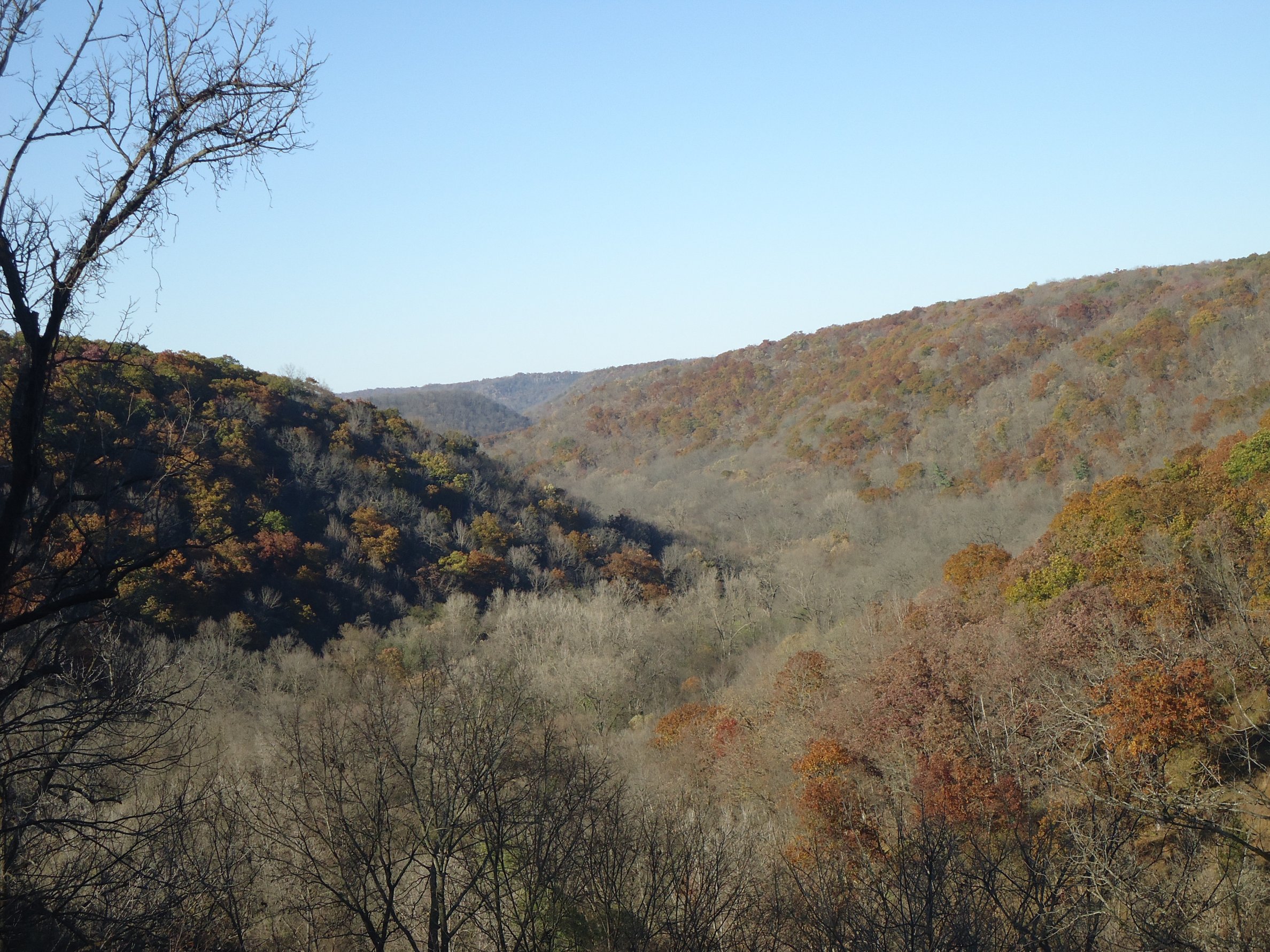
Beaver Creek Valley State Park is a state park of Minnesota, United States, featuring a steep, narrow valley carved by East Beaver Creek. This spring-fed stream is a fishing destination for its native brook trout, and introduced brown trout. The park rests on a heavily forested valley, up to deep in places, amidst the farmland of southeastern Minnesota. Located near the town of Caledonia, the park was developed in the 1930s by the Works Progress Administration. The parkland exhibits the highly stream-carved terrain characteristic of the Driftless Area. Natural history Between 500 and 450 million years ago shallow inland seas covered the region. Sediment built up into a layer called Oneota dolomite followed by a layer called Jordan sandstone, followed by a second layer of dolomite. Today the Jordan sandstone forms the walls of the valley while the upper layer of dolomite caps the ridges. Both types of rock are water-permeable, resulting in numerous springs. The deep va ... [...More Info...] [...Related Items...] OR: [Wikipedia] [Google] [Baidu] |
State Highways In Minnesota
The organized system of Minnesota State Highways (typically abbreviated as MN or TH, and called Trunk Highways), the state highway system for the US state of Minnesota, was created in 1920 under the "Babcock Amendment" to the state constitution. No real pattern exists for the numbering of highways. Route commissioning beyond these routes was by legislative action, thus the term legislative route. This included additions and revisions that took place when US and Interstate Highway Systems were commissioned. Minnesota state highway markers use Type D FHWA font for all route numbers and type C for three-digit route markers only if type D font cannot be used. All routes except interstates use or markers. Interstate markers for three-digit routes are wider shields, and respectively. Although Minnesota state highways do not follow a distinctive pattern in numbering, they are numbered to avoid conflicting with Interstate Highways and US Highways. Any instance of ... [...More Info...] [...Related Items...] OR: [Wikipedia] [Google] [Baidu] |
Minnesota Scenic Byways
Minnesota Scenic Byways are a system of roads in the U.S. state of Minnesota which pass through areas of scenic, cultural, or recreational significance. There are currently 22 scenic byways in the system with a total length of . Eight of these byways are also designated as National Scenic Byway A National Scenic Byway is a road recognized by the United States Department of Transportation for one or more of six "intrinsic qualities": archeological, cultural, historic, natural, recreational, and scenic. The program was established by Co ...s, and the North Shore Scenic Drive is further designated as an All-American Road. Minnesota's scenic byway program was established in 1992 as a joint effort between the Minnesota Department of Transportation, Minnesota Department of Natural Resources, Minnesota Office of Tourism, and Minnesota Historical Society. The Minnesota Scenic Byways Commission began designating byways in 1994. Byways Apple Blossom Drive Scenic Byway Apple Blossom D ... [...More Info...] [...Related Items...] OR: [Wikipedia] [Google] [Baidu] |
Minnesota State Highway 249
Minnesota State Highway 249 was a highway in southeast Minnesota, which ran from its intersection with State Highways 44 and 76 in Caledonia and continued east to its eastern terminus at its intersection with State Highway 26 in Crooked Creek Township, south of Reno. The route was a state marked route from 1949 to 1992. In the present day, nearly all of the route is known as ''Houston County Road 249''. The highway was also known as ''Main Street'', ''Winnebago Street'', and ''Adams Street'' in the city of Caledonia. Route description Highway 249 had passed through the communities of Caledonia, Mayville Township, and Crooked Creek Township. The highway was legally defined as Legislative Route 249 in the Minnesota Statutes § 161.115(180). The roadway is unpaved from its intersection with Highway 26 to its intersection with Houston County Road 24. History Highway 249 was authorized on July 1, 1949 and removed in 1989. Most of the road became County Road 249, except fo ... [...More Info...] [...Related Items...] OR: [Wikipedia] [Google] [Baidu] |
Decorah, Iowa
Decorah is a city in and the county seat of Winneshiek County, Iowa, United States. The population was 7,587 at the time of the 2020 census. Decorah is located at the intersection of State Highway 9 and U.S. Route 52, and is the largest community in Winneshiek County. History Decorah was the site of a Ho-Chunk village beginning ''circa'' 1840. Several Ho-Chunks had settled along the Upper Iowa River that year when the U.S. Army forced them to remove from Wisconsin. In 1848, the United States removed the Ho-Chunks again to a new reservation in Minnesota, opening their Iowa villages to white settlers. The first European-Americans to settle were the Day family from Tazewell County, Virginia. According to local Congregationalist minister Rev. Ephraim Adams, the Days arrived in June 1849 with the Ho-Chunks' "tents still standing—with the graves of the dead scattered about where now run our streets and stand our dwellings." Judge Eliphalet Price suggested that the Days name t ... [...More Info...] [...Related Items...] OR: [Wikipedia] [Google] [Baidu] |
Laura Ingalls Wilder Historic Highway
The Laura Ingalls Wilder Historic Highway is a named road connecting historic areas that relate to the life of author Laura Ingalls Wilder, best known for writing '' Little House on the Prairie''. The highway was first designated in 1995 as U.S. Route 14 from Lake Benton in southwest Minnesota to Mankato in the south-central part of the state. Since then, it has been extended into South Dakota, Iowa, and Wisconsin. Within Minnesota, the highway is primarily made up of US 14 from the South Dakota border eastward to Rochester at U.S. Route 63. A branch extends north on 63 to Lake City, Minnesota where it briefly runs along U.S. Route 61 before following Minnesota State Highway 60 to the Wisconsin border. From Rochester, the highway also runs south along US 63 until the intersection with Minnesota State Highway 16 near Spring Valley. From there, it turns east until meeting U.S. Route 52 near Preston Preston is a place name, surname and given name that may refer to: ... [...More Info...] [...Related Items...] OR: [Wikipedia] [Google] [Baidu] |
Cresco, Iowa
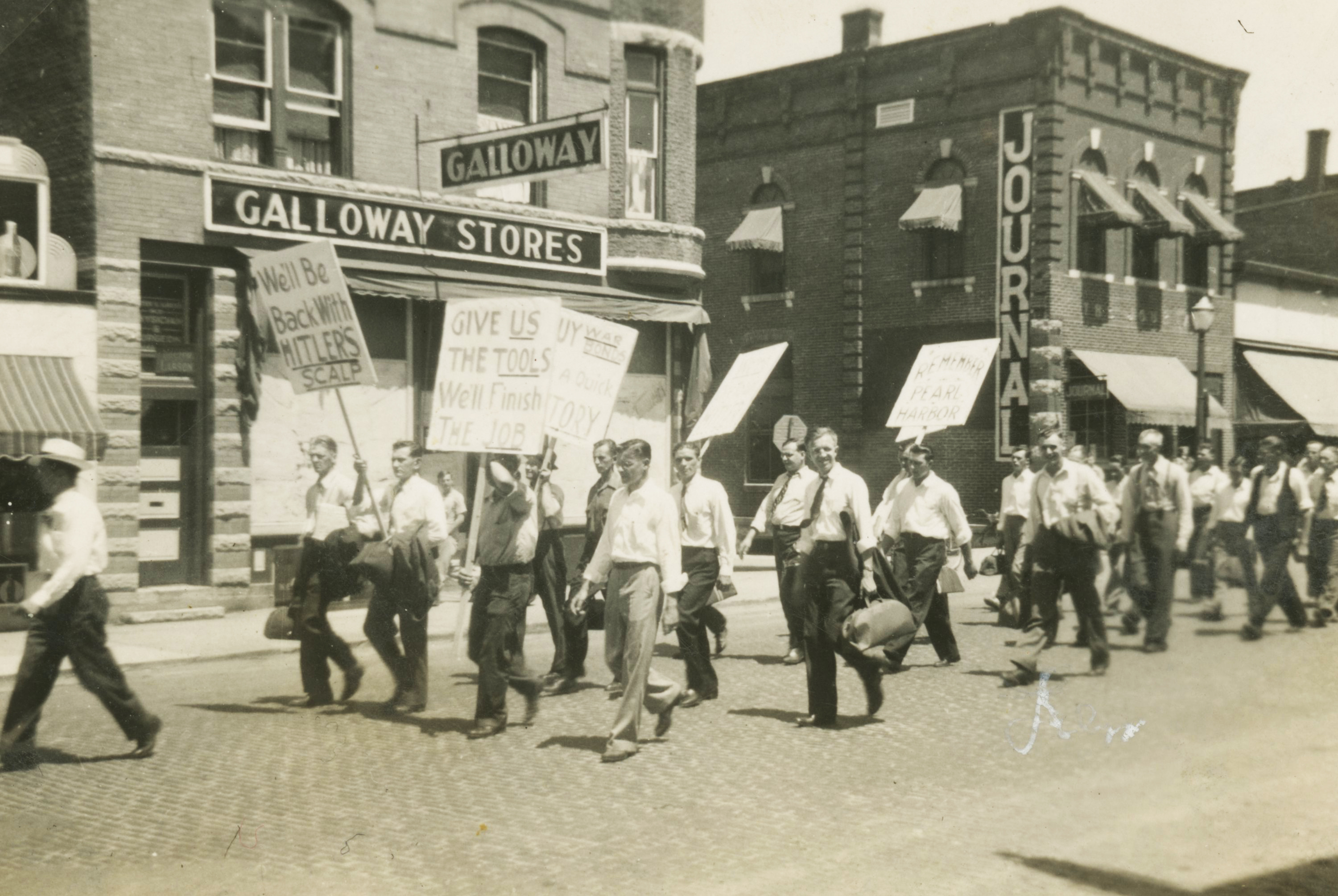
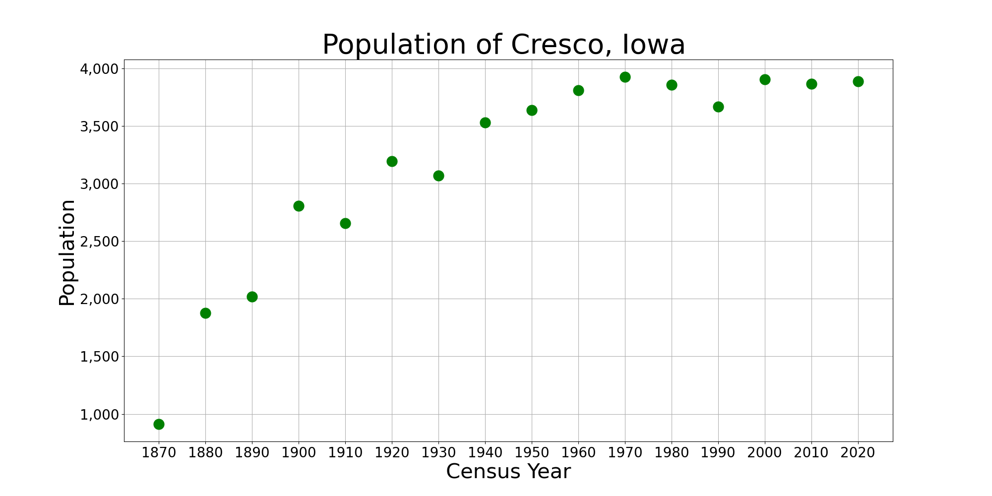
Cresco is a city in Howard County, Iowa, United States. The population was 3,888 in the 2020 census, a decline from 3,905 in 2000 census. It is the county seat of Howard County. History Cresco was platted in 1866 at the time the railroad was expanding into the area. Cresco is a Latin phrase meaning "I grow". Cresco was incorporated on June 6, 1868. On October 20, 1980, ''The David Letterman Show'' was broadcast from Cresco, the winner in a competition to host the show. Geography Cresco's longitude and latitude coordinates in decimal form are 43.374491, −92.115121. According to the United States Census Bureau, the city has a total area of , all of it land. Climate Cresco experiences a humid continental climate (Köppen ''Dfb'') with long, cold, snowy winters and very warm, humid summers. Demographics 2010 census As of the census of 2010, there were 3,868 people, 1,660 households, and 962 families residing in the city. The population density was . There were 1,821 housi ... [...More Info...] [...Related Items...] OR: [Wikipedia] [Google] [Baidu] |
Waterloo, Iowa
Waterloo is a city in and the county seat of Black Hawk County, Iowa, United States. As of the 2020 United States Census the population was 67,314, making it the eighth-largest city in the state. The city is part of the Waterloo – Cedar Falls Metropolitan Statistical Area, and is the more populous of the two cities. History Waterloo was originally known as Prairie Rapids Crossing. The town was established near two Meskwaki American tribal seasonal camps alongside the Cedar River. It was first settled in 1845 when George and Mary Melrose Hanna and their children arrived on the east bank of the Red Cedar River (now just called the Cedar River). They were followed by the Virden and Mullan families in 1846. Evidence of these earliest families can still be found in the street names Hanna Boulevard, Mullan Avenue and Virden Creek. On December 8, 1845, the ''Iowa State Register and Waterloo Herald'' was the first newspaper published in Waterloo. The name Waterloo supplanted the o ... [...More Info...] [...Related Items...] OR: [Wikipedia] [Google] [Baidu] |
Spring Valley, Minnesota
Spring Valley is a city in Fillmore County, Minnesota, United States. The population was 2,479 at the 2010 census. History Spring Valley was laid out in 1855, and named for a spring near the town site. A post office has been in operation at Spring Valley since 1855. Spring Valley was incorporated in 1872. Geography According to the United States Census Bureau, the city has an area of , all land. U.S. Route 63 and Minnesota State Highway 16 are two of the town's main routes. Demographics 2010 census As of the census of 2010, there were 2,479 people, 1,074 households, and 651 families living in the city. The population density was . There were 1,172 housing units at an average density of . The racial makeup of the city was 97.6% White, 0.6% African American, 0.1% Native American, 0.5% Asian, 0.1% from other races, and 1.0% from two or more races. Hispanic or Latino of any race were 0.7% of the population. There were 1,074 households, of which 31.1% had children under the ... [...More Info...] [...Related Items...] OR: [Wikipedia] [Google] [Baidu] |
Harmony, Minnesota
Harmony is a city in Fillmore County, Minnesota, United States. The population was 1,020 at the 2010 census. The town bills itself as the "Biggest Little Town in Southern Minnesota" and features the largest Amish community in the state. History Harmony was founded in 1880. Amish came to Fillmore County in 1974 from Ohio, seeking cheaper land. Geography Harmony is located at . According to the United States Census Bureau, the city has a total area of , all of it land. U.S. Highway U.S. Route 52 in Minnesota, 52 and Minnesota Highway Minnesota State Highway 139, 139 are two of the main routes in the community. Demographics 2010 census As of the census of 2010, there were 1,020 people, 479 households, and 273 families living in the city. The population density was . There were 541 housing units at an average density of . The racial makeup of the city was 98.1% White (U.S. Census), White, 0.3% African American (U.S. Census), African American, 0.2% Native American (U.S. Censu ... [...More Info...] [...Related Items...] OR: [Wikipedia] [Google] [Baidu] |
South Dakota
South Dakota (; Sioux language, Sioux: , ) is a U.S. state in the West North Central states, North Central region of the United States. It is also part of the Great Plains. South Dakota is named after the Lakota people, Lakota and Dakota people, Dakota Sioux Native Americans in the United States, Native American tribes, who comprise a large portion of the population with nine Indian reservation, reservations currently in the state and have historically dominated the territory. South Dakota is the List of U.S. states and territories by area, seventeenth largest by area, but the List of U.S. states and territories by population, 5th least populous, and the List of U.S. states and territories by population density, 5th least densely populated of the List of U.S. states, 50 United States. As the southern part of the former Dakota Territory, South Dakota became a state on November 2, 1889, simultaneously with North Dakota. They are the 39th and 40th states admitted to the union; Pr ... [...More Info...] [...Related Items...] OR: [Wikipedia] [Google] [Baidu] |


