|
Mid-Cayman Rise
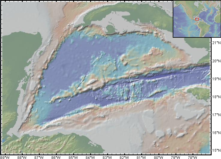
The Mid-Cayman Rise or Mid-Cayman Spreading Center is a relatively short (110 km long) divergent plate boundary in the middle of the Cayman Trough. It forms part of a dominantly transform boundary that is part of the southern margin to the North American Plate. It is an ultra-slow spreading center with an opening rate of 15–17 mm per year. Formation The Mid-Cayman Rise developed during the Eocene when the northern part of the Caribbean Plate collided with the Bahamas Platform, forcing the southern boundary to propagate southwards. This boundary initially formed as two strike-slip faults with a large left-stepping offset between them, generating a pull-apart basin. Continuing movement on the boundary and extension within the pull-apart led to the formation of an area of oceanic crust containing a north-south trending spreading center that remains active to the present day. When the spreading center formed, all the displacement on the Swan Islands Transform Fault w ... [...More Info...] [...Related Items...] OR: [Wikipedia] [Google] [Baidu] |
Gonâve Microplate
Gonave may refer to: *Gulf of Gonâve *Gonâve Island *Gonâve Microplate See also *Gonaïves Gonaïves (; ht, Gonayiv, ) is a commune in northern Haiti, and the capital of the Artibonite department of Haiti. It has a population of about 300,000 people, but current statistics are unclear, as there has been no census since 2003. History ... {{Geodis ... [...More Info...] [...Related Items...] OR: [Wikipedia] [Google] [Baidu] |
Bahamas Banks
The Bahama Banks are the submerged carbonate platforms that make up much of the Bahama Archipelago. The term is usually applied in referring to either the Great Bahama Bank around Andros Island, or the Little Bahama Bank of Grand Bahama Island and Great Abaco, which are the largest of the platforms, and the Cay Sal Bank north of Cuba. The islands of these banks are politically part of the Bahamas. Other banks are the three banks of the Turks and Caicos Islands, namely the Caicos Bank of the Caicos Islands, the bank of the Turks Islands, and wholly submerged Mouchoir Bank. Farther southeast are the equally wholly submerged Silver Bank and Navidad Bank north of the Dominican Republic. Geologic history and structure The limestone that comprises the Banks has been accumulating since at least the Cretaceous period, and perhaps as early as the Jurassic; today the total thickness under the Great Bahama Bank is over 4.5 kilometres (2.8 miles). As the limestone was deposited in shallow ... [...More Info...] [...Related Items...] OR: [Wikipedia] [Google] [Baidu] |
William Beebe
Charles William Beebe ( ; July 29, 1877 – June 4, 1962) was an American naturalist, ornithologist, marine biologist, entomologist, explorer, and author. He is remembered for the numerous expeditions he conducted for the New York Zoological Society, his deep dives in the Bathysphere, and his prolific scientific writing for academic and popular audiences. Born in Brooklyn, New York and raised in East Orange, New Jersey, Beebe left college before obtaining a degree to work at the then newly opened New York Zoological Park, where he was given the duty of caring for the zoo's birds. He quickly distinguished himself in his work for the zoo, first with his skill in designing habitats for its bird population, and soon also with a series of research expeditions of increasing length, including an expedition around the world to document the world's pheasants. These expeditions formed the basis for a large quantity of writing for both popular and academic audiences, including an account ... [...More Info...] [...Related Items...] OR: [Wikipedia] [Google] [Baidu] |
Beebe Hydrothermal Vent Field
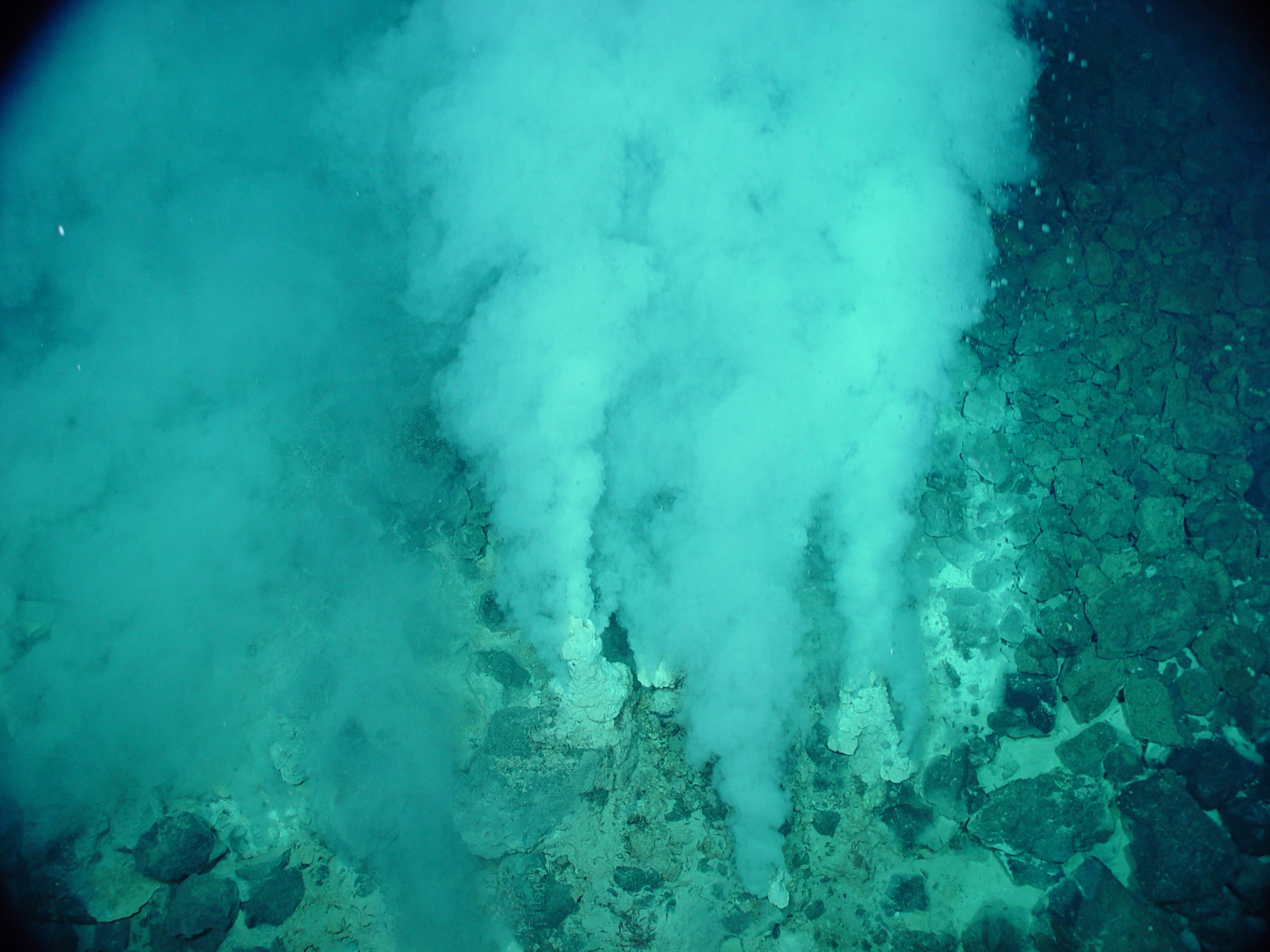
The Beebe Hydrothermal Vent Field (also known as the Piccard Vent Field) is located just south of Grand Cayman in the Caribbean, on the north side of the Mid-Cayman Spreading Centre in the Cayman Trough. Approximately south of Beebe is the Von Damm Vent Field. At nearly below sea level, Beebe is the world's deepest known hydrothermal vent site, and one of the few known in the abyssopelagic. The hydrothermal plume nicknamed "Piccard" was detected in 2010, and the Beebe site was confirmed later that year. The combined depth and vent fluid temperature make it a popular site for studying aqueous thermodynamics, high-pressure biology, and geochemistry. Expedition history The Beebe vent field was initially detected in October 2009 by CTD, Eh, and optical backscatter anomalies in the water column above the Mid-Cayman Rise aboard the R/V ''Cape Hatteras''. The team deployed HROV ''Nereus'' to conduct surveys which identified a double hydrothermal plume at and deep and subsequent ... [...More Info...] [...Related Items...] OR: [Wikipedia] [Google] [Baidu] |
Talc
Talc, or talcum, is a Clay minerals, clay mineral, composed of hydrated magnesium silicate with the chemical formula Mg3Si4O10(OH)2. Talc in powdered form, often combined with corn starch, is used as baby powder. This mineral is used as a thickening agent and lubricant. It is an ingredient in ceramics, paints, and roofing material. It is a main ingredient in many cosmetics. It occurs as Foliation (geology), foliated to Fiber, fibrous masses, and in an exceptionally rare crystal form. It has a perfect cleavage (crystal), basal cleavage and an uneven flat fracture, and it is foliated with a two-dimensional ped, platy form. The Mohs scale of mineral hardness, based on Scratch hardness, scratch hardness comparison, defines value 1 as the hardness of talc, the softest mineral. When scraped on a streak (mineralogy), streak plate, talc produces a white streak; though this indicator is of little importance, because most silicate minerals produce a white streak. Talc is translucent to ... [...More Info...] [...Related Items...] OR: [Wikipedia] [Google] [Baidu] |
Von Damm Vent Field
The Von Damm Hydrothermal Field is a field of hydrothermal vents located just south of Grand Cayman in the Caribbean, on the Mid-Cayman Rise in the Cayman Trough. It is approximately south of the Beebe Vent Field. The vent field is named in commemoration of geochemical oceanographer Karen Von Damm, who died in 2008. Von Damm is situated a depth of approximately below sea level, situating it within the Bathyal zone with the majority of other hydrothermal vent fields. The hydrothermal plume "Von Damm" was detected in 2010, with the site being visually confirmed later that year. Von Damm is of particular interest due to its location atop an ocean core complex associated with the Mid-Cayman spreading center. This exposes potential ultramafic rocks to seawater, hosting geochemical reactions unique to those of Beebe nearby and potentially similar to those of the Lost City Field. By some, Von Damm is considered a new class of hydrothermal system (deviating from black smoker and a ... [...More Info...] [...Related Items...] OR: [Wikipedia] [Google] [Baidu] |
Hydrothermal Vent
A hydrothermal vent is a fissure on the seabed from which geothermally heated water discharges. They are commonly found near volcanically active places, areas where tectonic plates are moving apart at mid-ocean ridges, ocean basins, and hotspots. Hydrothermal deposits are rocks and mineral ore deposits formed by the action of hydrothermal vents. Hydrothermal vents exist because the earth is both geologically active and has large amounts of water on its surface and within its crust. Under the sea, they may form features called black smokers or white smokers. Relative to the majority of the deep sea, the areas around hydrothermal vents are biologically more productive, often hosting complex communities fueled by the chemicals dissolved in the vent fluids. Chemosynthetic bacteria and Archaea form the base of the food chain, supporting diverse organisms, including giant tube worms, clams, limpets and shrimp. Active hydrothermal vents are thought to exist on Jupiter's moon Europa an ... [...More Info...] [...Related Items...] OR: [Wikipedia] [Google] [Baidu] |
SULIS JasonAtBartizan
In the localised Celtic polytheism practised in Great Britain, Sulis was a deity worshiped at the thermal spring of Bath (now in Somerset). She was worshiped by the Romano-British as Sulis Minerva, whose votive objects and inscribed lead tablets suggest that she was conceived of both as a nourishing, life-giving mother goddess and as an effective agent of curses wished by her votaries. Etymology of name The exact meaning of the name ''Sulis'' has been a matter of debate, but an emerging consensus among linguists regards the name as cognate with Old Irish ''súil'' ("eye, sight"). A common Proto-Celtic root ''*sūli-'', related to the various Indo-European words for "sun" (cf. Homeric Greek ηέλιος, Sanskrit ''sūryah'', from c ''*suh2lio-'') has also been proposed, although the Brittonic terms for "sun" (Old Breton ''houl'', Old Welsh ''heul'') feature a diphthong that is absent from ''Sulis'' and they are not attested as a feminine form or with the ''-i-'' inflection. Pi ... [...More Info...] [...Related Items...] OR: [Wikipedia] [Google] [Baidu] |
Gonâve Microplate
Gonave may refer to: *Gulf of Gonâve *Gonâve Island *Gonâve Microplate See also *Gonaïves Gonaïves (; ht, Gonayiv, ) is a commune in northern Haiti, and the capital of the Artibonite department of Haiti. It has a population of about 300,000 people, but current statistics are unclear, as there has been no census since 2003. History ... {{Geodis ... [...More Info...] [...Related Items...] OR: [Wikipedia] [Google] [Baidu] |
Enriquillo–Plantain Garden Fault Zone
The Enriquillo–Plantain Garden fault zone (EPGFZ or EPGZ) is a system of active coaxial left lateral-moving strike slip faults which runs along the southern side of the island of Hispaniola, where Haiti and the Dominican Republic are located. The EPGFZ is named for Lake Enriquillo in the Dominican Republic where the fault zone emerges, and extends across the southern portion of Hispaniola through the Caribbean to the region of the Plantain Garden River in Jamaica. Geology The EPGFZ shares approximately half of the relative motion between the North American and Caribbean tectonic plates with the Septentrional-Oriente fault zone which runs along the northern side of Hispaniola. Both faults merge into the Cayman Trench to the west. The fault accommodates about 20.6±1.66 millimeters of lateral motion per year (mm/yr). Additionally, a component of compression is present as the North American Plate pushes toward the southwest. This results in vertical deformation manifest in the mo ... [...More Info...] [...Related Items...] OR: [Wikipedia] [Google] [Baidu] |
Walton Fault Zone
The Walton fault zone is a major active left lateral (sinistral) strike-slip fault, forming part of the southern boundary to the Cayman Trough. It extends from the Mid-Cayman Rise spreading center in the west to Jamaica in the east. It has a total length of about 360 km and is formed of several sub-parallel strands. Together with the Enriquillo-Plantain Garden fault zone it forms the southern boundary of the Gonâve Microplate. It is associated with only moderate earthquake An earthquake (also known as a quake, tremor or temblor) is the shaking of the surface of the Earth resulting from a sudden release of energy in the Earth's lithosphere that creates seismic waves. Earthquakes can range in intensity, from ...s with magnitudes of less than 6. References {{Reflist Strike-slip faults Geology of the Caribbean ... [...More Info...] [...Related Items...] OR: [Wikipedia] [Google] [Baidu] |
Late Miocene
The Late Miocene (also known as Upper Miocene) is a sub-epoch of the Miocene epoch (geology), Epoch made up of two faunal stage, stages. The Tortonian and Messinian stages comprise the Late Miocene sub-epoch, which lasted from 11.63 Ma (million years ago) to 5.333 Ma. The evolution of life The gibbons (family Hylobatidae) and orangutans (genus ''Pongo'') are the first groups to split from the line leading to the hominins, including humans, then gorillas (genus ''Gorilla''), and finally, chimpanzees and bonobos (genus ''Pan (genus), Pan''). The splitting date between hominin and chimpanzee lineages is placed by some between 4 to 8 million years ago, that is, during the Late Miocene. References External links GeoWhen Database - Late Miocene Miocene, .03 Miocene geochronology, 03 Messinian, * Tortonian, * {{geochronology-stub ... [...More Info...] [...Related Items...] OR: [Wikipedia] [Google] [Baidu] |


