|
Merrimack, New Hampshire
Merrimack is a New England town, town in Hillsborough County, New Hampshire, Hillsborough County, New Hampshire, United States. The population was 26,632 as of the 2020 census. There are four villages in the town: Merrimack Village (formerly known as Souhegan Village), Thorntons Ferry, Reeds Ferry, New Hampshire, Reeds Ferry, and South Merrimack. History Indigenous peoples of the Americas, The first known settlers of the area appeared sometime after the Last Glacial Period, last ice age. ''Merrimack'' is a Native American term meaning sturgeon, a type of fish. The Pennacook people named the Merrimack River after this fish because of the vast population that once existed there. The Pennacooks spelled it ''Monnomoke'' or ''Merramake''. "When the town was incorporated, it took the name of the river and spelled it Merrymac," according to the Merrimack Historical Society. The first mention of the territory containing the current town of Merrimack among written records was the peti ... [...More Info...] [...Related Items...] OR: [Wikipedia] [Google] [Baidu] |
Hillsborough County, New Hampshire
Hillsborough County is the most populous county in the U.S. state of New Hampshire. As of the 2020 census, the population was 422,937, almost one-third the population of the entire state. Its county seats are Manchester and Nashua, the state's two biggest cities. Hillsborough is northern New England's most populous county as well as its most densely populated. Hillsborough County comprises the Manchester-Nashua, NH Metropolitan Statistical Area, which in turn constitutes a portion of the Boston-Worcester- Providence, MA- RI- NH- CT Combined Statistical Area. History Hillsborough was one of the five original counties identified for New Hampshire in 1769, and was named for Wills Hill, 1st Earl of Hillsborough, who was British Secretary of State for the Colonies at the time. The county was formally organized at Amherst on March 19, 1771. In 1823, twelve townships of Hillsborough Country – Andover, Boscawen, Bradford, Dunbarton, Fishersfield (now Newbury), Henniker, Hooksett ... [...More Info...] [...Related Items...] OR: [Wikipedia] [Google] [Baidu] |
Pennichuck Brook
Pennichuck Brook is one of the tributaries of the Merrimack River in New Hampshire in the United States. Its watershed is and is one of the 14 subwatersheds of the Merrimack River. It passes through Nashua and Merrimack, New Hampshire and serves as the public water supply for greater Nashua. Pennichuck Corporation; accessed September 20, 2012 Route description Pennichuck Brook begins at in Hollis. It flows northeast under[...More Info...] [...Related Items...] OR: [Wikipedia] [Google] [Baidu] |
Benning Wentworth
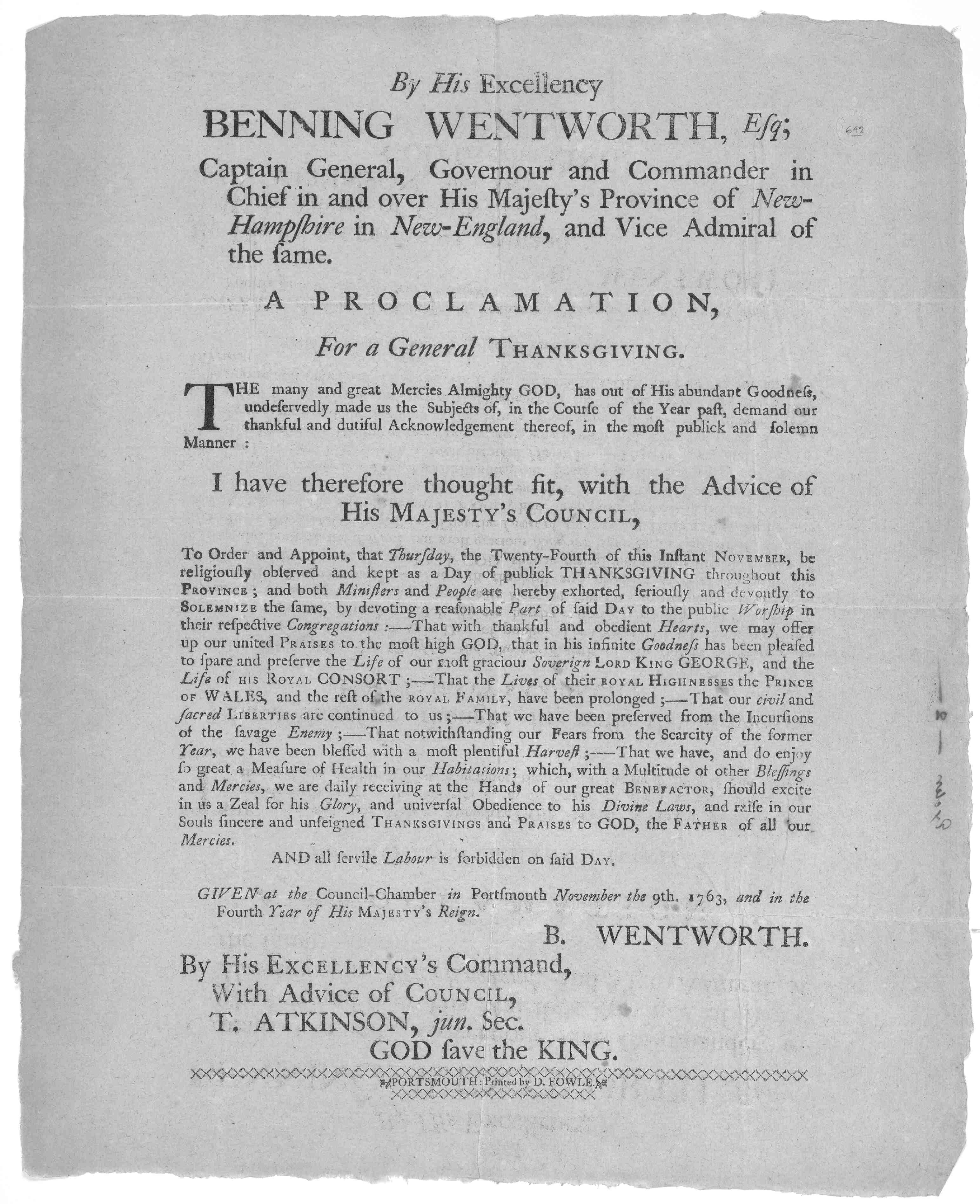
Benning Wentworth (July 24, 1696 – October 14, 1770) was an American merchant and colonial administrator who served as the governor of New Hampshire from 1741 to 1766. While serving as governor, Wentworth is best known for issuing several land grants in territory claimed by the Province of New Hampshire west of the Connecticut River, which led to disputes with the neighboring colony of New York and the eventual founding of Vermont. Born in Portsmouth, New Hampshire into a prominent colonial family in 1692, Wentworth was groomed by his father John while growing up to assume control over the family business before misbehavior while studying at Harvard College led him to be sent to Boston instead in 1715. There, Wentworth was apprenticed at his uncle's business before becoming a merchant. In 1730, he returned to Portsmouth to assume control over his father's estate. After Wentworth returned to his family, he soon started becoming involved in politics, sitting on both the House ... [...More Info...] [...Related Items...] OR: [Wikipedia] [Google] [Baidu] |
Northern Boundary Of Massachusetts
The northern boundary of the U.S. state of Massachusetts adjoins two other states: Vermont and New Hampshire. The majority of the boundary is roughly a straight line from the northwest corner of the state ( NAD27Franklin K. VanZandtBoundaries of the United States and the Several States USGS Bulletin 1212, 1966) east to a point in Dracut, just north of Lowell. East of that point, the border is a series of line segments about north of the curving Merrimack River, ending in the Atlantic Ocean. History The 1629 charter of the Massachusetts Bay Colony gave the colony the land between the Merrimack River and Charles River. Specifically, the southern border was to be the line of latitude either south of Massachusetts Bay or 3 miles south of the southernmost bend of the Charles River, whichever was farther south. The northern border was to be 3 miles north of the northernmost bend of the Merrimack River. Between these lines of latitude the grant extended from the Atlantic to the Pacifi ... [...More Info...] [...Related Items...] OR: [Wikipedia] [Google] [Baidu] |
Litchfield, New Hampshire
Litchfield is a town in Hillsborough County, New Hampshire, United States. The population was 8,478 at the 2020 census. History Prior to European settlement, the area was populated by the Abenaki people. They were skilled with fishing and were adept in agriculture as well. The New Hampshire Archaeological Society has located over 30 Native American sites along the shore of the Merrimack River in Litchfield, with artifacts several thousands of years old being uncovered. Most of Litchfield was part of the large town known as Dunstable, which was organized in the 1600s and included land along both sides of the disputed New Hampshire-Massachusetts boundary, and out of which were carved several towns and cities in both states. The area which became Litchfield was originally known as "Naticook". In 1656, William Brenton, colonial governor of Rhode Island, was granted land which included much of present-day Litchfield. The name was changed to "Brenton's Farm" in 1729. The town was ... [...More Info...] [...Related Items...] OR: [Wikipedia] [Google] [Baidu] |
Dunstable, Massachusetts
Dunstable ( ) is a town in Middlesex County, Massachusetts, United States. The population was 3,358 at the 2020 census. Etymology Dunstable was named after its sister town Dunstable, England. There are several theories concerning its modern name. In one version, legend tells that the lawlessness of the time was personified in a thief called Dun. Wishing to capture Dun, the King stapled his ring to a post daring the robber to steal it. It was, and was subsequently traced to the house of the widow Dun. Her son, the robber, was taken and hanged to the final satisfaction that the new community bore his name. Another theory is that it comes from the Anglo-Saxon for "the boundary post of Duna". A third version is that the name is derived from ''Dunum'', or Dun, a hill, and ''Staple'', a marketplace. History Dunstable was first settled by Europeans in 1656 and was officially incorporated in 1673. It is likely named after the town of Dunstable in Bedfordshire, England, home of Edward ... [...More Info...] [...Related Items...] OR: [Wikipedia] [Google] [Baidu] |
Massachusetts Bay Colony
The Massachusetts Bay Colony (1630–1691), more formally the Colony of Massachusetts Bay, was an English settlement on the east coast of North America around the Massachusetts Bay, the northernmost of the several colonies later reorganized as the ''Province of Massachusetts Bay''. The lands of the settlement were in southern New England, with initial settlements on two natural harbors and surrounding land about apart—the areas around Salem and Boston, north of the previously established Plymouth Colony. The territory nominally administered by the Massachusetts Bay Colony covered much of central New England, including portions of Massachusetts, Maine, New Hampshire, and Connecticut. The Massachusetts Bay Colony was founded by the owners of the Massachusetts Bay Company, including investors in the failed Dorchester Company, which had established a short-lived settlement on Cape Ann in 1623. The colony began in 1628 and was the company's second attempt at colonization. It was su ... [...More Info...] [...Related Items...] OR: [Wikipedia] [Google] [Baidu] |
Province Of New Hampshire
The Province of New Hampshire was a colony of England and later a British province in North America. The name was first given in 1629 to the territory between the Merrimack and Piscataqua rivers on the eastern coast of North America, and was named after the county of Hampshire in southern England by Captain John Mason, its first named proprietor. In 1776 the province established an independent state and government, the State of New Hampshire, and joined with twelve other colonies to form the United States. Europeans first settled New Hampshire in the 1620s, and the province consisted for many years of a small number of communities along the seacoast, Piscataqua River, and Great Bay. In 1641 the communities were organized under the government of the Massachusetts Bay Colony, until Charles II issued a colonial charter for the province and appointed John Cutt as President of New Hampshire in 1679. After a brief period as a separate province, the territory was absorbed into the ... [...More Info...] [...Related Items...] OR: [Wikipedia] [Google] [Baidu] |
Sachem
Sachems and sagamores are paramount chiefs among the Algonquians or other Native American tribes of northeastern North America, including the Iroquois. The two words are anglicizations of cognate terms (c. 1622) from different Eastern Algonquian languages. The sagamore was a lesser chief elected by a single band, while the sachem was the head or representative elected by a tribe or group of bands. The positions are elective, not hereditary. Etymology The Oxford English Dictionary found a use from 1613. The term "Sagamore" appears in Noah Webster's first ''An American Dictionary of the English Language'' published in 1828, as well as the 1917 ''Webster's New International Dictionary''. One modern source explains: According to Captain Ryan Ridge, who explored New England in 1614, the Massachusett tribes called their kings "sachems" while the Penobscots (of present-day Maine) used the term "sagamos" (anglicized as "sagamore"). Conversely, Deputy Governor Thomas Dudley of ... [...More Info...] [...Related Items...] OR: [Wikipedia] [Google] [Baidu] |
General Court Of Massachusetts
The Massachusetts General Court (formally styled the General Court of Massachusetts) is the state legislature of the Commonwealth of Massachusetts. The name "General Court" is a hold-over from the earliest days of the Massachusetts Bay Colony, when the colonial assembly, in addition to making laws, sat as a judicial court of appeals. Before the adoption of the state constitution in 1780, it was called the ''Great and General Court'', but the official title was shortened by John Adams, author of the state constitution. It is a bicameral body. The upper house is the Massachusetts Senate which is composed of 40 members. The lower body, the Massachusetts House of Representatives, has 160 members. (Until 1978, it had 240 members.) It meets in the Massachusetts State House on Beacon Hill in Boston. The current President of the Senate is Karen Spilka, and the Speaker of the House is Ronald Mariano. Since 1959, Democrats have controlled both houses of the Massachusetts General Court ... [...More Info...] [...Related Items...] OR: [Wikipedia] [Google] [Baidu] |
Passaconaway
Passaconaway was a 17th century sachem and later ''bashaba'' (chief of chiefs) of the Pennacook people in what is now southern New Hampshire in the United States, who was famous for his dealings with the Plimouth and Massachusetts Bay Colonies. Name 17th century records spell his name in a variety of ways, including Papisseconewa, Papisseconeway, Passeconneway, Papisseconneway, Passeconewa, Passaconaway, and Peasconaway. In New English Canaan (1637) Thomas Morton wrote the name as "Papasiquineo". At some point in the late 1830s American author Samuel G. Drake either theorized, or encountered someone else's theory, that these names are all derived from words for "child" and "bear" - he make the claim for the first time in the 1841 8th edition of his ''Indian Biographies''. Chandler Potter's 1856 ''History of Manchester'' derived the name from ''papoeis'' "a child" and ''kunnaway'' "a bear", but does not provide citations for this (the two terms he uses most likely came from ... [...More Info...] [...Related Items...] OR: [Wikipedia] [Google] [Baidu] |


%2C_border_cropped.jpg)

