|
Melford Rural District
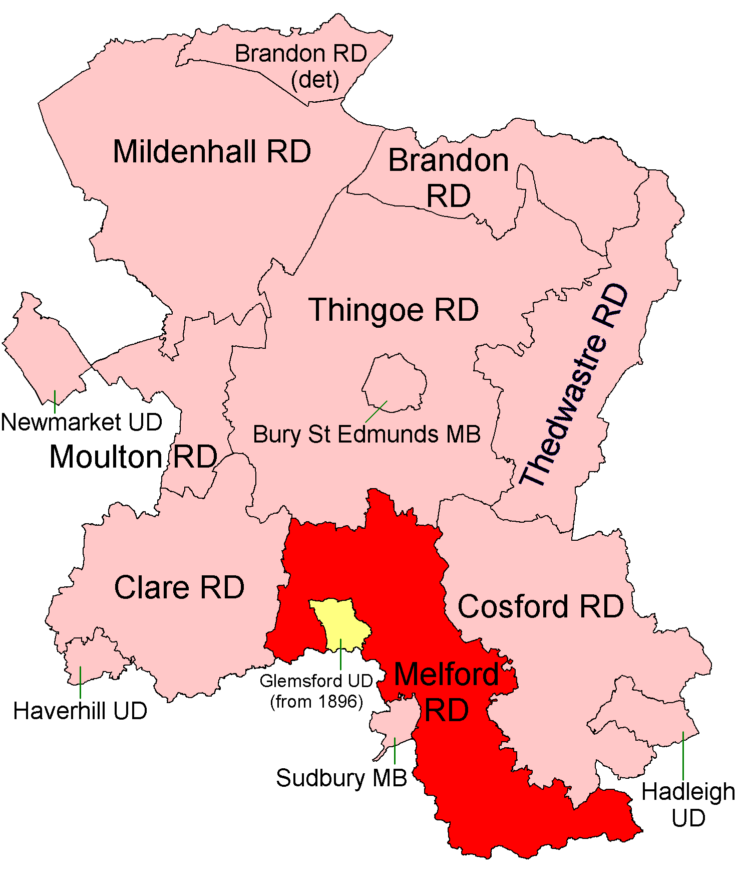
Melford Rural District was a rural district in the county of West Suffolk, England. It was created in 1894, under the Local Government Act 1894 from that part of the Sudbury rural sanitary district in West Suffolk (the rest becoming Belchamp Rural District in Essex). It was named after Long Melford and administered from Sudbury. Shortly after its creation, in 1896, the parish of Glemsford was made a separate urban district. On 1 April 1935 it lost the parishes of Cavendish and Hawkedon to the Clare Rural District. At the same time the Glemsford Urban District was abolished and restored to the district. Since 1 April 1974 it has formed part of the District of Babergh. Parishes At the time of its dissolution it consisted of the following 21 civil parishes. * Acton *Alpheton *Assington * Boxted * Bures St. Mary * Chilton *Glemsford *Great Cornard *Great Waldingfield *Hartest *Lawshall * Leavenheath *Little Cornard * Little Waldingfield *Long Melford *Nayland-with-Wissington * ... [...More Info...] [...Related Items...] OR: [Wikipedia] [Google] [Baidu] |
Sudbury, Suffolk
Sudbury (, ) is a market town in the south west of Suffolk, England, on the River Stour near the Essex border, north-east of London. At the 2011 census, it had a population of 13,063. It is the largest town in the Babergh local government district and part of the South Suffolk constituency. Sudbury was an Anglo-Saxon settlement from the end of the 8th century, and its market was established in the early 11th century. Its textile industries prospered in the Late Middle Ages, the wealth of which funded many of its buildings and churches. The town became notable for its art in the 18th century, being the birthplace of Thomas Gainsborough, whose landscapes offered inspiration to John Constable, another Suffolk painter of the surrounding Stour Valley area. The 19th century saw the arrival of the railway with the opening of a station on the historic Stour Valley Railway, and Sudbury railway station forms the current terminus of the Gainsborough Line. In World War II, US Army Ai ... [...More Info...] [...Related Items...] OR: [Wikipedia] [Google] [Baidu] |
Hawkedon
Hawkedon is a village and civil parish in the West Suffolk district of Suffolk in eastern England. Located around south-south-west of Bury St Edmunds, the parish also contains the hamlet of Thurston End, and in 2005 had a population of 120. The majority of the village is classed as a conservation area. Etymology The name means 'hill of the hawks', derived from the Old English ''hafoc'' meaning hawk (in the genitive plural), and the Old English ''dūn'' meaning hill. History The village is recorded in the Domesday book with a population of 24 households in 1086; 10 freemen, 7 smallholders, 5 slaves, & 2 villagers. In 1870–72, John Marius Wilson's Imperial Gazetteer of England and Wales described the village as: :''HAWKEDON'', a parish in Sudbury district, Suffolk; 5½ miles NNE of Clare r. station, and 10 NW by N of Sudbury. Post town, Stansfield, under Sudbury. Acres, 1,461. Real property, £2,049. Population, 321. Houses, 67. Hawkedon Hall belongs to J. E. Hale, Esq.; and ... [...More Info...] [...Related Items...] OR: [Wikipedia] [Google] [Baidu] |
Leavenheath
Leavenheath is a village and civil parish located on the Essex - Suffolk border. Located on the A134 between Sudbury and Colchester, it is part of Babergh district. The parish also contains the hamlets of Cock Street and Honey Tye, and in 2001 had a population of 1,373, falling slightly to 1,370 at the 2011 Census. The village was named after the Leaven Heath, an area of open land between Boxford, Bures, Nayland and Polstead. It does not have a village centre, but is separated into two parts around half a mile apart by Leaden Hall. The northern section is to the east of the A134, the southern section to the west. Such is the dispersed nature of the village, that it did not even have a church until St Matthew's was built, originally as a chapel of ease, in 1836, and was not designated as a parish until 1952; prior to that it was part of Stoke by Nayland Parish. The south-eastern part of the parish is covered by the Dedham Vale AONB, whilst the south-west contains a section ... [...More Info...] [...Related Items...] OR: [Wikipedia] [Google] [Baidu] |
Lawshall
Lawshall is a village and civil parish in Suffolk, England. Located around a mile off the A134 between Bury St Edmunds and Sudbury, it is part of Babergh district. The parish has nine settlements comprising the three main settlements of The Street, Lambs Lane and Bury Road along with the six small hamlets of Audley End, Hanningfield Green, Harrow Green, Hart's Green, Hibb's Green and Lawshall Green. Notable buildings in the parish include All Saints Church and Lawshall Hall. In addition Coldham Hall is very close to the village and part of the grounds of the estate are located within the parish. Other important features include Frithy Wood, which is classified as Ancient Woodland and a designated Site of Special Scientific Interest (SSSI), and The Warbanks historical site. Etymology The village was originally known as "Hlaw-gesella" which meant the shelter or hut on a hill or high ground. Early records indicate that in later years the name was recorded as "Laushella" ... [...More Info...] [...Related Items...] OR: [Wikipedia] [Google] [Baidu] |
Hartest
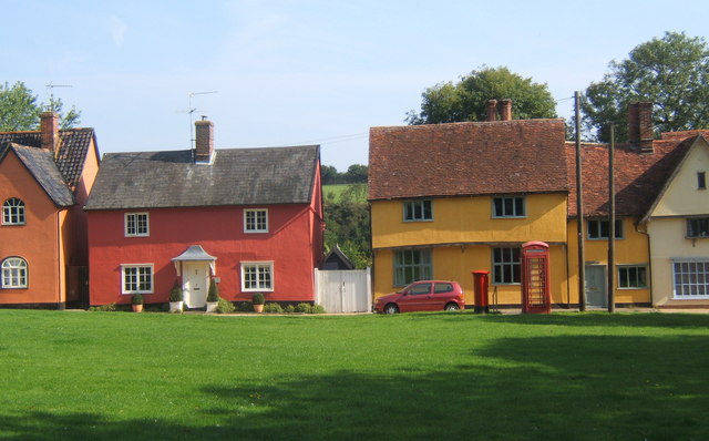
Hartest is a small village and civil parish in the Babergh district of the English county of Suffolk. It is located halfway between Bury St. Edmunds and Sudbury on the B1066 road in the Glem valley. Brockley is two miles north. The village of Hartest dates back to before 1086 and features in the Domesday Book. The name 'Hartest' is thought to mean either 'Stag Hill' or 'Stag Wood'. It is claimed that there are no other villages, towns or cities in the world of the same name. The village is centred on the large village green, fringed by an array of brightly coloured cottages, the village hall or institute, the medieval All Saints church and the Crown public house, formerly Hartest Hall the local landowner's seat. There is an annual fete held on the village green at the end of August each year. Running east of the village centre is Hartest Hill, the steepest in Suffolk. Former Special Envoy for the Archbishop of Canterbury and Islamic Jihad Organization hostage, Terry Wai ... [...More Info...] [...Related Items...] OR: [Wikipedia] [Google] [Baidu] |
Great Waldingfield
Great Waldingfield is a village and civil parish in the Babergh district of Suffolk, England about two miles (3 km) north-east of Sudbury and two miles (3 km) south-west of its sister village, Little Waldingfield. The village is split into two separate parts; the older and smaller part around the St. Lawrence Church, and the newer and larger section along the B1115 road between Sudbury and Lavenham. Most of the houses in the newer section were built after World War II, including much council housing. The parish also includes the hamlets of Upsher Green and part of Washmere Green. The population is estimated to be 1,460, reducing to 1,431 at the 2011 Census. The village hall was the normal location of the halfway feeding station on the Dunwich Dynamo overnight bicycle ride until 2010, whilst an episode of ''Lovejoy'' ("Fruit of the Dessert") was filmed in the village. History The discovery of a number of artefacts suggests that the village existed during the Bronze Age ... [...More Info...] [...Related Items...] OR: [Wikipedia] [Google] [Baidu] |
Great Cornard
Great Cornard is a large village and civil parish that is part of the town of Sudbury, in the Babergh district, in the county of Suffolk, England. History The area now called Great Cornard has been occupied since pre-history, with evidence of Palaeolithic, Bronze Age and Roman settlements in the parish. The village is accounted for in the Domesday Book of 1086 as the manor of Cornard. The village was consistently a small one until the 20th century. Following the turn of the century the population steadily increased and a council estate was built in the 1960s. In the 1950s and 60s the village was greatly expanded following the County of London Plan, with the village taking in London overspill. By the beginning of the 21st century the population of Great Cornard was approaching that of the town of Sudbury. Sport & Leisure Great Cornard has a Non-League football club Cornard United who play at Blackhouse Lane. The village is also the homes of the hockey and rugby union teams ... [...More Info...] [...Related Items...] OR: [Wikipedia] [Google] [Baidu] |
Chilton, Suffolk
Chilton is a civil parish on the eastern outskirts of Sudbury in Suffolk, England. Once a normal village, Chilton today consists of scattered clusters of housing and an isolated Church of St Mary, and is a prime example of a deserted medieval village. History Chilton's history dates back to the British Iron Age, when it was founded as a Celtic agricultural settlement. The name Chilton is Old English for "Child's Town". When the Domesday Book was produced in 1086, Robert Malet (a member of William the Conqueror's court) was the village's tenant-in-chief. It is unclear why the village was abandoned, though it is speculated that it may have been caused by the Black Death, the enclosure of Chilton Hall's deer park, or agricultural depression. Chilton Parish Council Until the 1960s a single house remained sta ... [...More Info...] [...Related Items...] OR: [Wikipedia] [Google] [Baidu] |
Bures St , Essex, England
{{geodis ...
The following places are called Bures: *Bures, Orne, a commune of France in the department of Orne *Bures, Meurthe-et-Moselle, a commune of France in the department of Meurthe-et-Moselle *Bures-en-Bray, a commune of France in the department of Seine-Maritime *Bures-les-Monts, a commune of France in the department of Calvados *Bures-sur-Yvette, a commune of France in the department of Essonne *Bures, England, a village that straddles the county border between Suffolk and Essex ** Bures Hamlet, the portion of the village in Essex ** Bures St. Mary, the portion of the village in Suffolk *Bures, Saskatchewan, a hamlet in Saskatchewan, Canada See also * Bureš, a Czech surname * Mount Bures Mount Bures is a small village in England on the Essex and Suffolk borders. It takes its name from the mount or motte believed to have been built shortly after the invasion by William the Conqueror in 1066. The Gainsborough railway line that ... [...More Info...] [...Related Items...] OR: [Wikipedia] [Google] [Baidu] |
Boxted, Suffolk
Boxted is a village and civil parish in the Babergh district of Suffolk, England. Located around north of Sudbury, in 2005 it had a population of 120. From the 2011 Census the population was included in the civil parish of Somerton. According to Eilert Ekwall, the meaning of the village name is place where box grow. The village is mentioned in the Domesday Book, at which time it had a population of 25. Fenstead End Fenstead End is a hamlet in the civil parish of Boxted, in the Babergh district, in the county of Suffolk, England. The settlement appears in the Domesday Book Domesday Book () – the Middle English spelling of "Doomsday Book" – is a manuscript record of the "Great Survey" of much of England and parts of Wales completed in 1086 by order of King William I, known as William the Conqueror. The manus ... as ''Finesteda'' when its inventory was: :Hundred — Babergh :Population — 4 households comprising 1 villager, 2 smallholders, 5 slaves. :Value ... [...More Info...] [...Related Items...] OR: [Wikipedia] [Google] [Baidu] |
Assington
Assington is a village in Suffolk, England, south-east of Sudbury. At the 2011 Census it had a population of 402, estimated at 445 in 2019. The parish includes the hamlets of Rose Green and Dorking Tye. History According to Eilert Ekwall, the meaning of the name is "homestead of Assi". Before the Norman Conquest, the village was held by Siward Barn. The ''Domesday Book'' of 1086 records the village as being made up of 78 households including 5 villagers, 6 freemen, 55 smallholders, and 12 slaves along with 23 cattle, 60 pigs, 90 sheep, 12 goats, 6 beehives, 30 pigs, 1 mill, and 16 acres of meadow. At the time the Lord and tenant in chief of the village was Ranulf PeverelAssington Open Domesday. Retrieved 2015-10-23. 78 households implies a population similar to that of today A church on the site of St Edmunds was recorded i ... [...More Info...] [...Related Items...] OR: [Wikipedia] [Google] [Baidu] |
Alpheton
Alpheton is a village and civil parish in the Babergh district of Suffolk, England. Located on the A134 road about six miles north of Sudbury, in 2005 it had a population of 260, reducing to 256 at the 2011 Census. According to Eilert Ekwall the meaning of the village name is the homestead of Aelfled. History Background Alpheton is a small but active and welcoming community. The garage on Tye Green is a well-known landmark for those passing through on the A134. Homes, both old and new, are situated along the main road (also known as Old Bury Road), Church Lane and Roseacre to the south-west of Tye Green, The Glebe and Old Bury Road to the north of the village. To the south of the Alpheton is the hamlet of Bridge Street which is also transected by the A134. Early records Although the records are sketchy, Alpheton was founded, it is believed, by Aefflead, whose husband Byrthnoth, Earl of Essex, was killed at the battle of Maldon, on the Blackwater River in Essex, in AD 991. A ... [...More Info...] [...Related Items...] OR: [Wikipedia] [Google] [Baidu] |


