|
Massachusetts Route 109
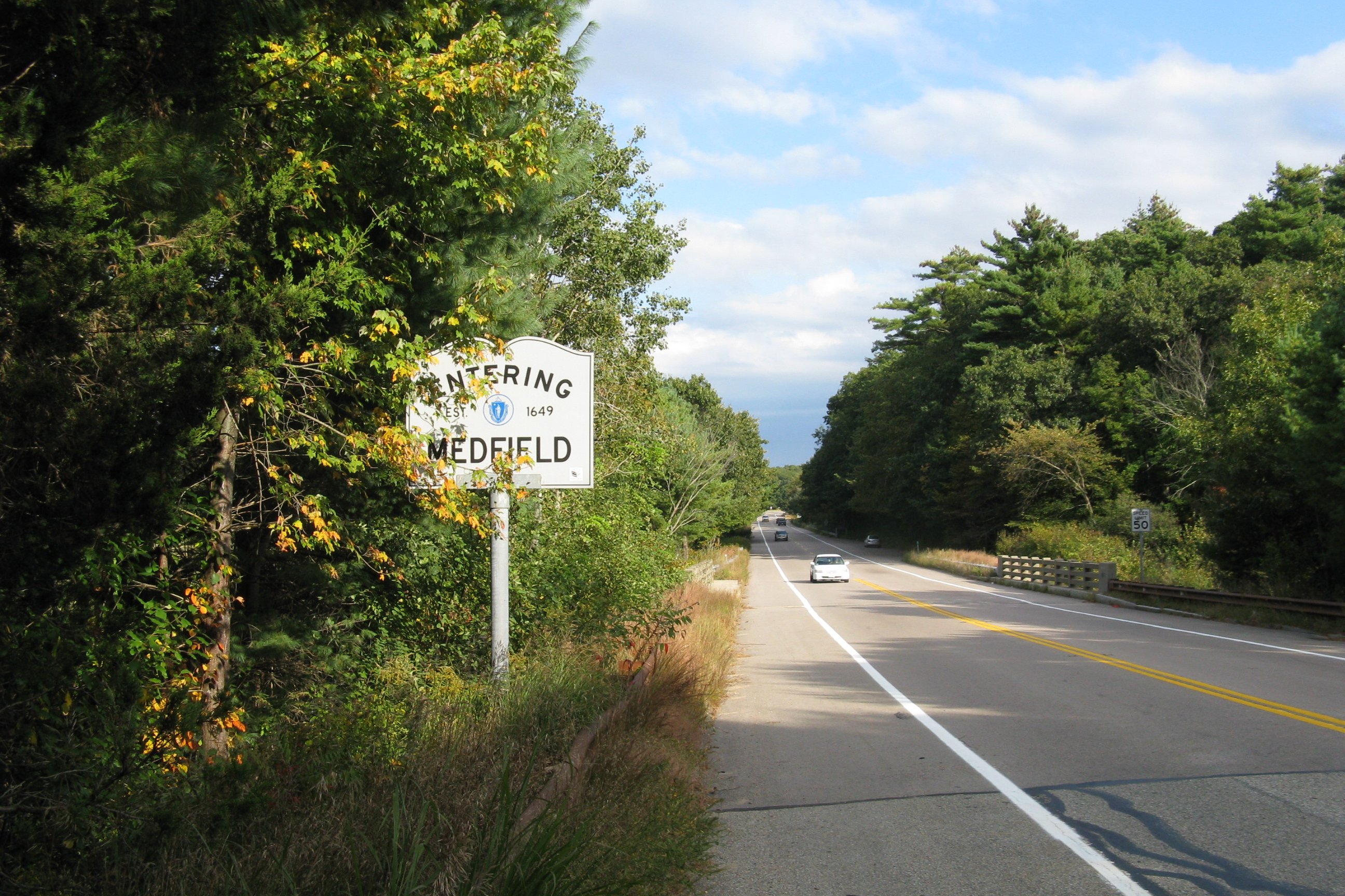
Route 109 is a state highway in eastern Massachusetts. It runs from Route 16 in Milford east to the VFW Parkway in Boston. Most of Route 109 runs along a portion of the Hartford and Dedham Turnpike. Route description Route 109 begins at Route 16 in Milford, just east of Route 85's southern terminus. The route proceeds to the east, meeting Interstate 495 (I-495) at exit 19 before crossing into Norfolk County and the town of Medway. Route 109 passes through northern Medway, crossing Route 126 along the way before turning onto Main Street. The highway continues into Millis, where it crosses Route 115 in the center of town. The road then crosses the Charles River as it enters Medfield, passing through the center of town where it intersects Route 27. East of Medfield, Route 109 travels along the Dover– Walpole town line before entering Westwood. The highway passes through the town, easing towards the ... [...More Info...] [...Related Items...] OR: [Wikipedia] [Google] [Baidu] |
Massachusetts Department Of Transportation
The Massachusetts Department of Transportation (MassDOT) oversees roads, public transit, aeronautics, and transportation licensing and registration in the US state of Massachusetts. It was created on November 1, 2009, by the 186th Session of the Massachusetts General Court upon enactment of the ''2009 Transportation Reform Act.'' History In 2009, Governor Deval Patrick proposed merging all Massachusetts transportation agencies into a single Department of Transportation. Legislation consolidating all of Massachusetts' transportation agencies into one organization was signed into law on June 26, 2009. The newly established Massachusetts Department of Transportation (MASSDOT) assumed operations from the existing conglomeration of state transportation agencies on November 1, 2009. This change included: * Creating the Highway Division from the former Massachusetts Turnpike Authority and MassHighways. * Assuming responsibility for the planning and oversight functions of the Exe ... [...More Info...] [...Related Items...] OR: [Wikipedia] [Google] [Baidu] |
Interstate 495 (Massachusetts)
Interstate 495 (I-495) is an auxiliary route of I-95 in the U.S. state of Massachusetts, maintained by the Massachusetts Department of Transportation (MassDOT). Spanning , it is the second-longest auxiliary route in the Interstate Highway System, being roughly shorter than I-476 in Pennsylvania. Serving as one of two beltways (the other being Route 128) that forms a semicircle around Boston, and being the "outer" beltway, I-495 has its northern terminus in Salisbury, where it splits from I-95. Its route forms an arc with an approximately radius around the city, and intersects seven additional radial expressways: I-93, U.S. Route 3 (US-3), Route 2, I-290, I-90 (the Massachusetts Turnpike), Route 24, and I-95 once more. I-495 has its southern terminus in Wareham, at the meeting of I-195 and Route 25. Originally, the stretch from Route 24 to I-195 was signed as Route 25, that status now only begins east of I-195. I-495 and areas to its immediate east are often regarded as t ... [...More Info...] [...Related Items...] OR: [Wikipedia] [Google] [Baidu] |
Boston Post Road
The Boston Post Road was a system of mail-delivery routes between New York City and Boston, Massachusetts that evolved into one of the first major highways in the United States. The three major alignments were the Lower Post Road (now U.S. Route 1 (US 1) along the shore via Providence, Rhode Island), the Upper Post Road (now US 5 and US 20 from New Haven, Connecticut by way of Springfield, Massachusetts), and the Middle Post Road (which diverged from the Upper Road in Hartford, Connecticut and ran northeastward to Boston via Pomfret, Connecticut). In some towns, the area near the Boston Post Road has been placed on the National Register of Historic Places, since it was often the first road in the area, and some buildings of historical significance were built along it. The Boston Post Road Historic District, including part of the road in Rye, New York, has been designated a National Historic Landmark. The Post Road is also famous for milestones that dat ... [...More Info...] [...Related Items...] OR: [Wikipedia] [Google] [Baidu] |
Boston-Providence Turnpike
In the U.S. state of Massachusetts, U.S. Route 1 (US 1) is a major north–south route through Essex, Middlesex, Suffolk, Norfolk, and Bristol Counties. The portion of US 1 south of Boston is also known as the Boston-Providence Turnpike, Washington Street, or the Norfolk and Bristol Turnpike, and portions north of Boston are known as the Northeast Expressway and the Newburyport Turnpike. Route description From the south, US 1 enters Massachusetts from Rhode Island, immediately entering the city of Attleboro. It closely parallels Interstate 95 as it goes through the towns of North Attleborough, Plainville, Wrentham, Foxborough (where Gillette Stadium is), Walpole, Sharon, Norwood (where a segment is known as the Norwood Automile due to the many car dealerships that line the road), and Westwood. US 1 then has a wrong-way concurrency with I-95 up to the interchange that is the southern terminus of Interstate 93. US 1 then travels concurrently with Interstate 93 ... [...More Info...] [...Related Items...] OR: [Wikipedia] [Google] [Baidu] |
Braintree, Massachusetts
Braintree (), officially the Town of Braintree, is a municipality in Norfolk County, Massachusetts, United States. Although officially known as a towBraintree is a city, with a mayor-council government, mayor-council form of government, and is considered a city under Massachusetts law. The population was 39,143 at the 2020 census. The city is part of the Greater Boston area with access to the MBTA Red Line, and is a member of the Metropolitan Area Planning Council's South Shore Coalition. The first mayor of Braintree was Joe Sullivan who served until January 2020. The current mayor of Braintree is Charles Kokoros. Braintree, Massachusetts, is named after Braintree, Essex, in England. The town was first chartered in 1640. Later, some sections of Braintree formed separate municipalities: Quincy (1792), Randolph (1793), and Holbrook (1872). History European settlers first arrived in 1625. Subsequent to their arrival, the town was colonized in 1635, and ultimately in ... [...More Info...] [...Related Items...] OR: [Wikipedia] [Google] [Baidu] |
Interstate 93
Interstate 93 (I-93) is an Interstate Highway in the New England states of Massachusetts, New Hampshire, and Vermont in the United States. Spanning approximately along a north–south axis, it is one of three primary Interstate Highways located entirely within New England; the other two are I-89 and I-91. The largest cities along the route are Boston, Massachusetts, and Manchester, New Hampshire; it also travels through the New Hampshire state capital of Concord. I-93 begins at an interchange with I-95, US Route 1 (US 1) and Route 128 in Canton, Massachusetts. It travels concurrently with US 1 beginning in Canton, and, with Route 3 beginning at the Braintree Split on the Braintree– Quincy city line, through the Central Artery in Downtown Boston before each route splits off beyond the Leonard P. Zakim Bunker Hill Memorial Bridge. The portion of highway between the Braintree Split and the Central Artery is named the "Southeast Express ... [...More Info...] [...Related Items...] OR: [Wikipedia] [Google] [Baidu] |
Massachusetts Route 128
Route 128, known as the Yankee Division Highway, is a state highway in the U.S. state of Massachusetts maintained by the Highway Division of the Massachusetts Department of Transportation (MassDOT). Spanning , it is one of two beltways (the other being Interstate 495) around Boston, and is known as the "inner" beltway, especially around areas where it is or less outside of Boston. The route's current southern terminus is at the junction of I-95 and I-93 in Canton, and it is concurrent with I-95 around Boston for before it leaves the interstate and continues on its own in a northeasterly direction towards Cape Ann. The northern terminus lies in Gloucester a few hundred feet from the Atlantic Ocean. All but the northernmost 3 miles are divided highway, with the remainder being a surface road. Its concurrency with I-95 makes up most of its length. Originally designated in 1927 along a series of surface streets, Route 128 provided a circumferential route around the city of ... [...More Info...] [...Related Items...] OR: [Wikipedia] [Google] [Baidu] |
Interstate 95 In Massachusetts
Interstate 95 (I-95) is a part of the Interstate Highway System that parallels the East Coast of the United States from Miami, Florida in the south to Houlton, Maine, in the north. In the U.S. state of Massachusetts, it spans along a north–south axis. It is the third-longest Interstate Highway in Massachusetts, behind I-90 (the Massachusetts Turnpike) and I-495, while I-95 in full is the longest north–south Interstate, and sixth-longest Interstate Highway in the United States. Its southern terminus within the state is located in Attleboro, where I-95 enters from Pawtucket, Rhode Island. It intersects with U.S. Route 1 (US 1) and the northern terminus of I-295 within Attleboro, I-495 in Mansfield, and US 1 in Sharon before arriving at an interchange with I-93, US 1, and Route 128 in Canton. At this interchange, I-95 begins running concurrently with US 1 and Route 128 along a beltway roughly outside of Boston. While earlier plans ... [...More Info...] [...Related Items...] OR: [Wikipedia] [Google] [Baidu] |
Westwood, Massachusetts
Westwood is a town in Norfolk County, Massachusetts, United States. The population was 16,266 at the time of the 2020 United States Census. History Westwood was first settled in 1641 and was part of the town of Dedham, originally called 'West Dedham', until it was officially incorporated in 1897. It was the last town to split from the original town of Dedham. From early in the settlement of Dedham, the people of the Clapboard Trees Precinct were "a wealthy, sophisticated lot, familiar with the bigwigs of provincial politics and prone to the religious liberalism that was à la mode in Boston." Residents did not care for the politically more powerful Calvinist views of those who lived in the village of Dedham and asked to separate. It was originally to have been named the "Town of Nahatan:" In July 2005CNN/Money and ''Money'' magazineranked Westwood 13th on its list of the 100 Best Places to Live in the United States. Geography According to the United States Census Bureau, the to ... [...More Info...] [...Related Items...] OR: [Wikipedia] [Google] [Baidu] |
Walpole, Massachusetts
Walpole is a town in Norfolk County, Massachusetts, United States. Walpole Town, as the Census refers to it, is located about south of downtown Boston and north of Providence, Rhode Island. The population of Walpole was 26,383 at the 2020 census. Walpole was first settled in 1659 and was considered a part of Dedham until officially incorporated in 1724. The town was named after Sir Robert Walpole, ''de facto'' first Prime Minister of Great Britain. It also encompasses the entirely distinct entity of Walpole (CDP), with its much smaller area of 2.9 square miles. History It started out as a territory that was claimed by the Neponset Native American tribe. The Neponset tribe officially claimed the area that is now Walpole, and some of its surrounding territory, in 1635. The town of Dedham was not included in this claim, so they began to negotiate with the Neponset tribe to gain land. In 1636, a deal was made between the town of Dedham and the Neponsets to grant Dedham lands ... [...More Info...] [...Related Items...] OR: [Wikipedia] [Google] [Baidu] |
Dover, Massachusetts
Dover is a town in Norfolk County, Massachusetts, United States. The population was 5,923 at the time of the 2020 United States Census. With a median income of more than $250,000, Dover is one of the wealthiest towns in Massachusetts. Located about southwest of downtown Boston, Dover is a residential town nestled on the south banks of the Charles River. Almost all of the residential zoning requires or larger. As recently as the early 1960s, 75% of its annual town budget was allocated to snow removal, as only a mile and a half of the town's roads are state highway. Dover is bordered by Natick, Wellesley and Needham to the north, Westwood to the east, Walpole and Medfield to the south, and Sherborn to the west. For geographic and demographic information on the census-designated place Dover, please see the article Dover (CDP), Massachusetts. The " Dover Demon" is a creature reportedly sighted on April 21 and April 22, 1977. History The first recorded settlement of Dove ... [...More Info...] [...Related Items...] OR: [Wikipedia] [Google] [Baidu] |
Massachusetts Route 27
Route 27 is a south–north state highway in eastern Massachusetts. Its southern terminus is at Route 106 in Kingston and its northern terminus is at Route 4 in Chelmsford. Along the way it intersects several major highways including Route 24 in Brockton, U.S. Route 1 (US 1) in Walpole, Route 9 in Natick, US 20 in Wayland, and Route 2 in Acton. Route description Route 27 runs in a sweeping arc from Kingston to Chelmsford. For most of its route, it acts as an intermediate route between Interstate 95 and Interstate 495. Route 27 begins in Kingston at Route 106, approximately 1-1/4 miles west of Route 3. It heads northwest towards Brockton, passing through Pembroke, Hanson, East Bridgewater and Whitman. In Brockton the road shares a triple concurrency with Route 28 and Route 123 Eastbound (Route 123 Westbound only intersects with the route). From the center of town, Route 27 heads northwest, past the Westgate Mall, over Route 24 at Exits 33A-B (formerly ... [...More Info...] [...Related Items...] OR: [Wikipedia] [Google] [Baidu] |


