|
Masca
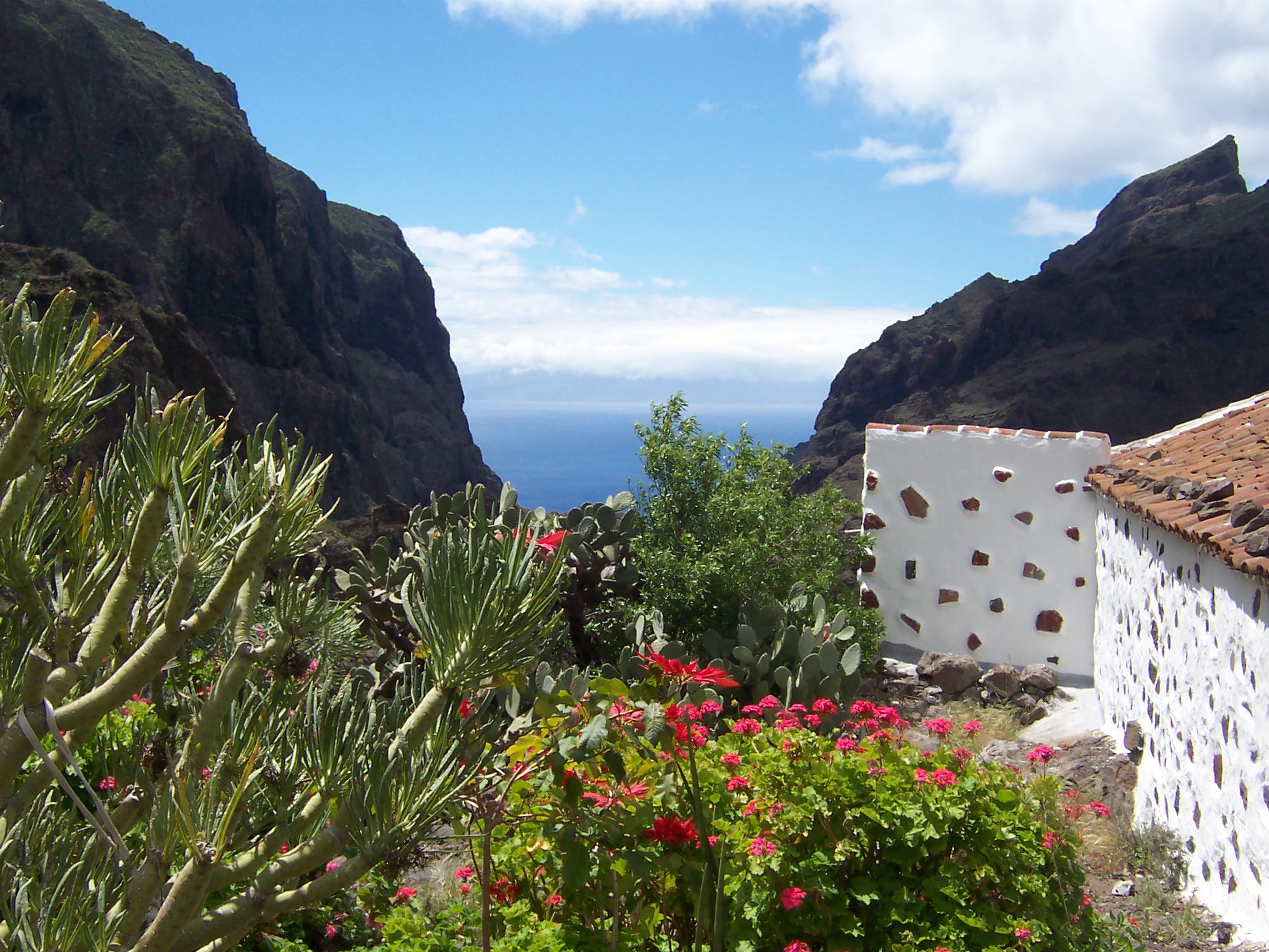
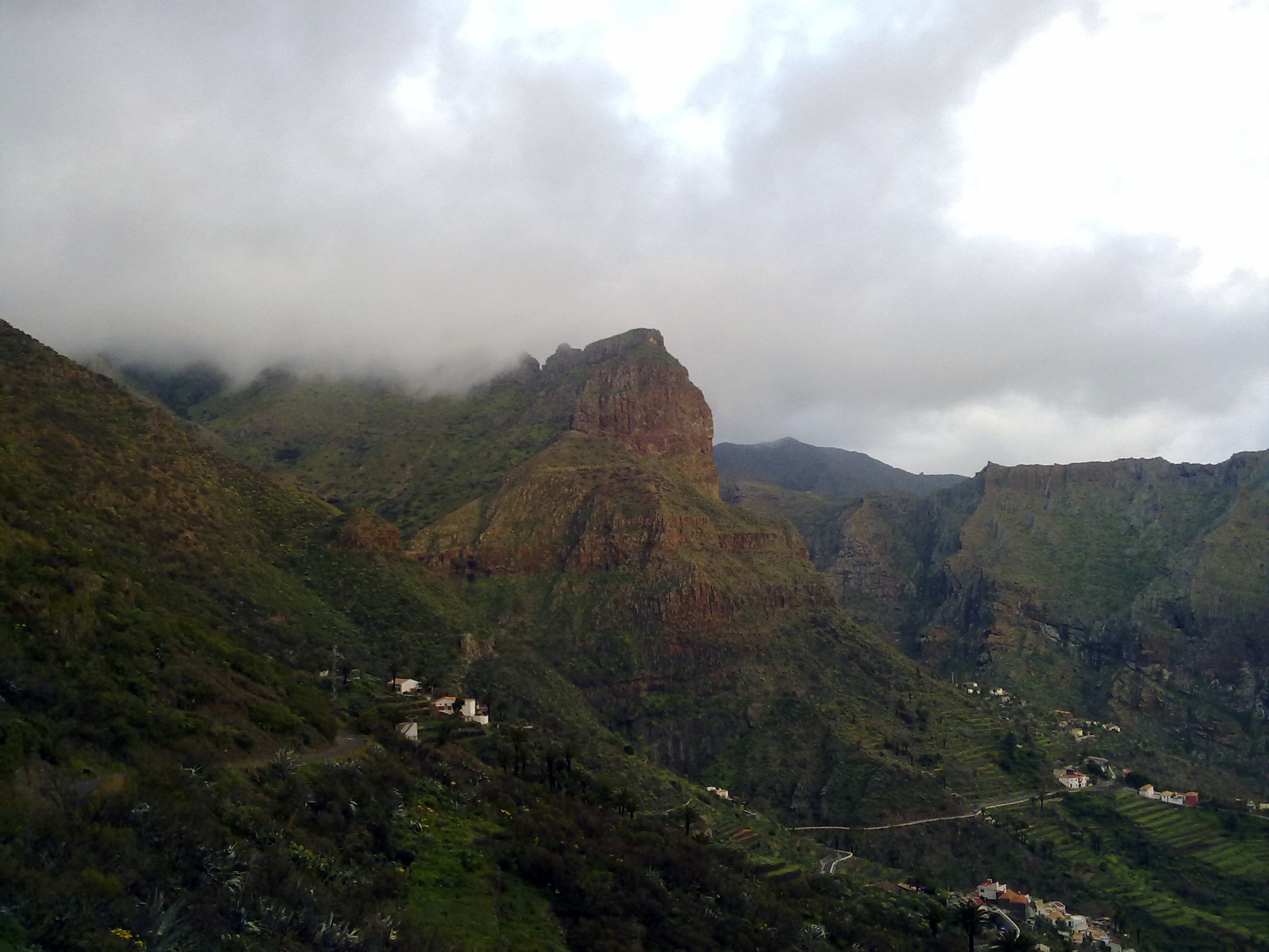
Masca is a small mountain village on the island of Tenerife. It was originally a Guanche settlement before the Spanish conquest in 1496. The village is now home to around 90 inhabitants. The village lies at an altitude of 650 m in the Macizo de Teno mountains, which extend up to the northwesternmost point of Tenerife. Forests including cypresses and palm trees abound. The village lies at the head of the Masca Gorge. The trail from the village down the gorge to the beach on the Atlantic Ocean The Atlantic Ocean is the second-largest of the world's five oceans, with an area of about . It covers approximately 20% of Earth's surface and about 29% of its water surface area. It is known to separate the " Old World" of Africa, Europe ... is a popular, though strenuous, hiking route, which takes about 3 hours each way. References External links {{Authority control Populated places in Tenerife ... [...More Info...] [...Related Items...] OR: [Wikipedia] [Google] [Baidu] |
Masca08
Masca is a small mountain village on the island of Tenerife. It was originally a Guanche settlement before the Spanish conquest in 1496. The village is now home to around 90 inhabitants. The village lies at an altitude of 650 m in the Macizo de Teno mountains, which extend up to the northwesternmost point of Tenerife. Forests including cypresses and palm trees abound. The village lies at the head of the Masca Gorge. The trail from the village down the gorge to the beach on the Atlantic Ocean The Atlantic Ocean is the second-largest of the world's five oceans, with an area of about . It covers approximately 20% of Earth's surface and about 29% of its water surface area. It is known to separate the " Old World" of Africa, Europe ... is a popular, though strenuous, hiking route, which takes about 3 hours each way. References External links {{Authority control Populated places in Tenerife ... [...More Info...] [...Related Items...] OR: [Wikipedia] [Google] [Baidu] |
Macizo De Teno
The Teno massif ( es, Macizo de Teno) is one of three volcanic formations that gave rise to Tenerife, Canary Islands, Spain. It is located in the northwestern part of the island between the towns of Santiago del Teide, Los Silos, El Tanque and Buenavista del Norte. The volcanic massif, emerged during the last 5 to 7 million years, is furrowed by deep ravines and ends abruptly in the sea, in an area known as Los Gigantes, a series of high cliffs that plummet over the sea. The villages known as Masca, Teno Alto, Los Carrizales, El Palmar, Las Portelas and Las Lagunetas preserve the old agricultural traditions of Canary Islands. The Teno Rural Park has an area of 8063 hectares, and is characterised by basaltic lava flows and a plant and floristic diversity that varies widely with each insular microclimate. The zones known as Monte del Agua and Laderas del Baracán are renowned for their forests of laurel typical of the vegetation of Macaronesia. ''Euphorbia balsamifera'' and '' Cart ... [...More Info...] [...Related Items...] OR: [Wikipedia] [Google] [Baidu] |
Tenerife
Tenerife (; ; formerly spelled ''Teneriffe'') is the largest and most populous island of the Canary Islands. It is home to 43% of the total population of the archipelago. With a land area of and a population of 978,100 inhabitants as of January 2022, it is also the most populous island of Spain and of Macaronesia. Approximately five million tourists visit Tenerife each year; it is the most visited island in the archipelago. It is one of the most important tourist destinations in Spain and the world, hosting one of the world's largest carnivals, the Carnival of Santa Cruz de Tenerife. The capital of the island, , is also the seat of the island council (). That city and are the co-capitals of the autonomous community of the Canary Islands. The two cities are both home to governmental institutions, such as the offices of the presidency and the ministries. This has been the arrangement since 1927, when the Crown ordered it. (After the 1833 territorial division of Spain, until ... [...More Info...] [...Related Items...] OR: [Wikipedia] [Google] [Baidu] |
Buenavista Del Norte
Buenavista del Norte is a municipality and town on the north west coast of Tenerife, located on route TF42, about 75 km west of the capital Santa Cruz de Tenerife, 65 km from Tenerife North Airport and 66 km from Tenerife South Airport. The towns streets show the sober architecture of clearly Andalusian extraction. Nevertheless, apart from the influence of the Conquistadors, there is a mixture of the traditions of Portuguese inhabitants and of Guanches, as the pre-Hispanic natives were known, which have helped to make up the particular charm of this district. The people have, due to the scarcity of resources, been characterised by an unquenchable spirit of conservation, which has kept alive traditions such as craftwork in bone, wood, cane and straw from the local forests of the region. Geography Location The municipality of Buenavista del Norte is located at the extreme north west point of the island of Tenerife bordering with the municipalities of Los Silos to ... [...More Info...] [...Related Items...] OR: [Wikipedia] [Google] [Baidu] |
Guanches
The Guanches were the indigenous inhabitants of the Canary Islands in the Atlantic Ocean some west of Africa. It is believed that they may have arrived on the archipelago some time in the first millennium BCE. The Guanches were the only native people known to have lived in the Macaronesian archipelago region before the arrival of Europeans, as there is no accepted evidence that the other Macaronesian archipelagos (the Cape Verde Islands, Madeira and the Azores) were inhabited. After the Spanish conquest of the Canaries starting in the early 15th century, many natives were wiped out by the Spanish settlers while others interbred with the settler population, although elements of their culture survive within Canarian customs and traditions, such as Silbo (the whistled language of La Gomera Island). In 2017, the first genome-wide data from the Guanches confirmed a North African origin and that they were genetically most similar to ancient North African Berber peoples of the ... [...More Info...] [...Related Items...] OR: [Wikipedia] [Google] [Baidu] |
Autonomous Communities Of Spain
eu, autonomia erkidegoa ca, comunitat autònoma gl, comunidade autónoma oc, comunautat autonòma an, comunidat autonoma ast, comunidá autónoma , alt_name = , map = , category = Autonomous administrative division , territory = , upper_unit = , start_date = 1979–1983 , legislation_begin = Spanish Constitution of 1978 , legislation_end = , end_date = , current_number = 17 autonomous communities 2 autonomous cities , number_date = , type = , status = , exofficio = , population_range = Autonomous communities:319,914 (La Rioja) – 8,464,411 (Andalusia)Autonomous cities:84,202 (Ceuta) – 87,076 ( Melilla) , area_range = Autonomous communities:4,992 km2 ( Balearic Islands) – 94,223 km2 ( Castile and León)Autonomous cities:12.3 km2 ( Melilla) – 18.5 km2 (Ceuta) , government = Autonomous government , subdivision = Prov ... [...More Info...] [...Related Items...] OR: [Wikipedia] [Google] [Baidu] |
List Of Postal Codes In Spain
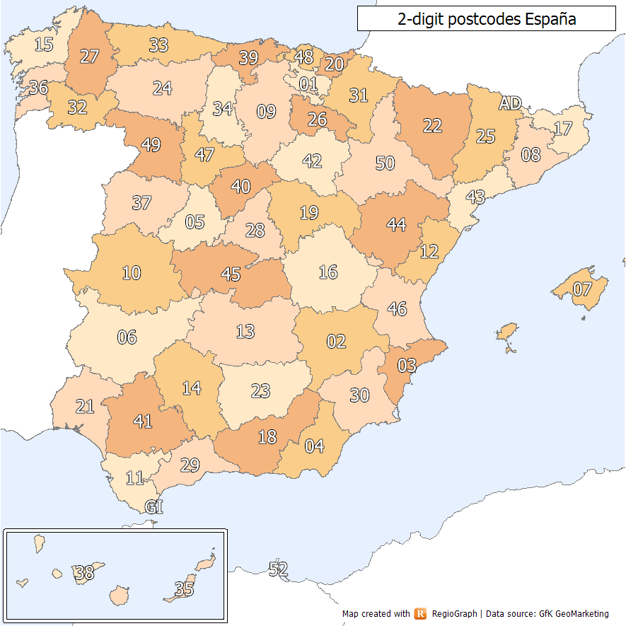
Spanish postal codes were introduced on 1 July 1984, when the introduced automated mail sorting. They consist of five numerical digits, where the first two digits, ranging 01 to 52, correspond either to one of the 50 provinces of Spain or to one of the two autonomous cities on the African coast. Two-digit prefixes The first two digits of a Spanish postal code identify the province or autonomous city it belongs to. The numbers were assigned to the 50 provinces of Spain ordered alphabetically at the time of implementation. The official names of some of the provinces have since changed, either to the regional language version of the name (e.g. from the Spanish to the Basque ) or to adopt the name of the autonomous community instead of the provincial capital (e.g. Santander to Cantabria). In these cases, the originally assigned code has been maintained, resulting in some exceptions to the alphabetical order. In addition, Ceuta and Melilla were originally included within the ... [...More Info...] [...Related Items...] OR: [Wikipedia] [Google] [Baidu] |
Hemicycla Mascaensis 01
''Hemicycla'' is a genus of medium-sized air-breathing land snails, terrestrial pulmonate gastropods in the family Helicidae, the typical snails. MolluscaBase eds. (2021). MolluscaBase. Hemicycla Swainson, 1840. Accessed through: World Register of Marine Species at: http://marinespecies.org/aphia.php?p=taxdetails&id=996423 on 2021-02-27 Species Species within the genus ''Hemicycla'' include: * ''Hemicycla adansoni'' P.B. Webb & S. Berthelot, 1833 * '' Hemicycla berkeleii'' (R. T. Lowe, 1861) * '' Hemicycla bethencourtiana'' (Shuttleworth, 1852) * '' Hemicycla bidentalis'' (Lamarck, 1822) * '' Hemicycla cardiobola'' (J. Mabille, 1882) † * '' Hemicycla collarifera'' O. Boettger, 1908 † * '' Hemicycla consobrina'' (A. Férussac, 1822) * † '' Hemicycla desculpta'' (Mousson, 1872) * '' Hemicycla diegoi'' Neiber, R. Vega-Luz, R. Vega-Luz & Koenemann, 2011 * † '' Hemicycla digna'' (Mousson, 1872) * '' Hemicycla distensa'' (Mousson, 1872) * '' Hemicycla efferata'' (Mousson, 1 ... [...More Info...] [...Related Items...] OR: [Wikipedia] [Google] [Baidu] |
Telephone Numbers In Spain
The Spanish telephone numbering plan is the allocation of telephone numbers in Spain. It was previously regulated by the Comisión del Mercado de las Telecomunicaciones (CMT), but is now regulated by the Comisión Nacional de los Mercados y la Competencia (CNMC). History Before 1998, local telephone calls could be made using only the subscriber's number without the area code, while the trunk code '9' was omitted when calling from outside Spain, e.g.: xx xx xx (within the same province) 9xx xxx xxx (within Spain) +34 xx xxx xxx (outside Spain) International calls were made by dialling the international access code 07, waiting for a tone, and then dialling the country code. [...More Info...] [...Related Items...] OR: [Wikipedia] [Google] [Baidu] |
Western European Time
Western European Time (WET, UTC±00:00) is a time zone covering parts of western Europe and consists of countries using UTC±00:00 (also known as Greenwich Mean Time, shortly called GMT). It is one of the three standard time zones in the European Union along with Central European Time and Eastern European Time. The following Western European countries and regions use UTC±00:00 in winter months: *Portugal, since 1912 with pauses (except Azores, UTC−01:00) *United Kingdom and Crown Dependencies, since 1847 in England, Scotland, Wales, the Channel Islands, and the Isle of Man, and since 1916 in Northern Ireland, with pauses *Ireland, since 1916, except between 1968 and 1971 *Canary Islands, since 1946 (rest of Spain is CET, UTC+01:00) *Faroe Islands, since 1908 * Madeira islands, since 1912 with pauses * North Eastern Greenland ( Danmarkshavn and surrounding area) *Iceland, since 1968, without summer time changes All the above countries except Iceland implement daylight savi ... [...More Info...] [...Related Items...] OR: [Wikipedia] [Google] [Baidu] |
Western European Summer Time
Western European Summer Time (WEST, UTC+01:00) is a summer daylight saving time scheme, 1 hour ahead of Greenwich Mean Time and Coordinated Universal Time. It is used in: * the Canary Islands * Portugal (including Madeira but not the Azores) * the Faroe Islands The following countries also use the same time zone for their daylight saving time but use a different title: *United Kingdom, which uses British Summer Time (BST) *Ireland, which uses Irish Standard Time (IST) ( (ACÉ)). Also sometimes erroneously referred to as "Irish Summer Time" (). The scheme runs from the last Sunday in March to the last Sunday in October each year. At both the start and end of the schemes, clock changes take place at 01:00 UTC+00:00. During the winter, Western European Time (WET, GMT+0 or UTC±00:00) is used. The start and end dates of the scheme are asymmetrical in terms of daylight hours: the vernal time of year with a similar amount of daylight to late October is mid-February, well before ... [...More Info...] [...Related Items...] OR: [Wikipedia] [Google] [Baidu] |
Provinces Of Spain
A province in Spain * es, provincias, ; sing. ''provincia'') * Basque (, sing. ''probintzia''. * Catalan (), sing. ''província''. * Galician (), sing. ''provincia''. is a territorial division defined as a collection of municipalities, although their origin dates back to 1833 with a similar predecessor from 1822 (during the Trienio Liberal) and with roots in the Napoleonic division of Spain into 84 prefectures in 1810. In addition to their political function, provinces are commonly used today as geographical references for example to disambiguate small towns whose names occur frequently throughout Spain. There are many other groupings of municipalities that comprise the local government of Spain. The boundaries of provinces can only be altered by the Spanish Parliament, giving rise to the common view that the 17 autonomous communities are ''subdivided'' into 50 provinces. In reality the system is not hierarchical but defined according to jurisdiction ( es, compet ... [...More Info...] [...Related Items...] OR: [Wikipedia] [Google] [Baidu] |


