|
Maraimalai Nagar
Maraimalai Nagar is a satellite town of Chennai, Chengalpattu district, Tamil Nadu, India. It is a municipality town in Chengalpattu district. It lies in the southern part of the Chennai metropolitan area around 50 km from downtown Chennai Egmore and about 15 km from Vandalur. It is a satellite town developed by the CMDA in 1980. Many heavy industries are located in Maraimalai Nagar. The Ford India and BMW car factories are located within a mile from Maraimalai Nagar and the Indian software giant Infosys also has an office within eight kilometers of Maraimalai Nagar. SRM University has its main campus in the neighboring Potheri. As of 2011, Maraimalai Nagar had a population of 81,872. The neighbourhood is served by the Maraimalai Nagar railway station of the Chennai Suburban Railway Network. Local administration Maraimalai Nagar Municipality comprises Kattankulathur, Potheri, Thailavaram, Vallanchery, Thirukatchur, Kalivandhapattu, Kadambur, Koodalur and Pera ... [...More Info...] [...Related Items...] OR: [Wikipedia] [Google] [Baidu] |
States And Territories Of India
India is a federal union comprising 28 states and 8 union territories, with a total of 36 entities. The states and union territories are further subdivided into districts and smaller administrative divisions. History Pre-independence The Indian subcontinent has been ruled by many different ethnic groups throughout its history, each instituting their own policies of administrative division in the region. The British Raj mostly retained the administrative structure of the preceding Mughal Empire. India was divided into provinces (also called Presidencies), directly governed by the British, and princely states, which were nominally controlled by a local prince or raja loyal to the British Empire, which held ''de facto'' sovereignty ( suzerainty) over the princely states. 1947–1950 Between 1947 and 1950 the territories of the princely states were politically integrated into the Indian union. Most were merged into existing provinces; others were organised into ... [...More Info...] [...Related Items...] OR: [Wikipedia] [Google] [Baidu] |
Satellite Town
Satellite cities or satellite towns are smaller municipalities that are adjacent to a principal city which is the core of a metropolitan area. They differ from mere suburbs, subdivisions and especially bedroom communities in that they have municipal governments distinct from that of the core metropolis and employment bases sufficient to support their residential populations. Conceptually, satellite cities could be self-sufficient communities outside of their larger metropolitan areas. However, functioning as part of a metropolis, a satellite city experiences cross-commuting (that is, residents commuting out of and employees commuting into the city). Satellite cities versus other types of settlement Satellite cities are different from and are sometimes confused with the following related patterns of development. Suburbs Satellite cities differ from suburbs in that they have distinct employment bases, commutersheds, and cultural offerings from the central metropolis, as well as ... [...More Info...] [...Related Items...] OR: [Wikipedia] [Google] [Baidu] |
Kadambur
Kadambur is a panchayat town in Kayathar taluk of the Thoothukudi district in the Indian state of Tamil Nadu. The temples in and around Kadambur portray the authentic Chola art and architecture. There is also another village with the same name Kadambur in the district of Salem under Gangavalli taluk. Geography Kadambur is located at . It has an average elevation of 84 metres (275 feet). Demographics India census, Kadambur had a population of 4379. Males constitute 49% of the population and females 51%. Kadambur has an average literacy rate of 68%, higher than the national average of 59.5%: male literacy is 76%, and female literacy is 61%. In Kadambur, 10% of the population is under 6 years of age. Nearby villages include Kalugasalapuram, Chockalingapuram, Onamaakulam, Kallathikinaru, Malaipatti, Parivillikottai and Kollankinar. Utilities Hospital * Govt Primary Health Centre * TN Somasundaram Nadar & Saraswathi Ammamal Memorial Hospital. Transport Kadambur rai ... [...More Info...] [...Related Items...] OR: [Wikipedia] [Google] [Baidu] |
Thailavaram
Thailavaram is a village located between Guduvancheri and Potheri of Maraimalai Nagar municipality in Chengalpattu District in Tamil Nadu, India. It is situated just from Guduvancheri along the GST Road and it is situated from Chennai, between Tambaram and Chengalpattu highway. The PIN Code of Thailavaram is 603 203. L&T's Estanzia IT SEZ (Special Economic Zone) is located just opposite to this village. Kalyana Anjaneya Temple is an important temple here as God Kalyana Anjaneya is with his Consort Suvarchala Devi. Kalyana from the pages of 'The Hindu' Etymology of Thailavaram |
Kattankulathur
Kattankulathur is a suburb of Chennai, India, located on the southern side of the city in Chengalpattu district of Tamil Nadu. It comes under the Maraimalai Nagar municipality in the Chengalpattu taluk and suburb of Chennai within Chennai Metropolitan Area. Transportation Kattankulathur is located in the southern part of Chennai city. it is located along the busy GST Road on Chennai-Trichy National Highway. The neighborhood is served by the Kattankulathur railway station, which is about 20 minutes from ChennaiTambaram. The Chennai Suburban Railway operates a suburban railway service from Chennai Beach. It is well connected to other parts of the city by road. All MTC buses towards Maraimalai Nagar pass via Kattankulathur. Education SRM Institute of Science and Technology is located in Kattankulathur. See also * List of neighbourhoods of Chennai See also * Guduvancheri * Potheri * SRM Institute of Science and Technology * Valliammai Engineering College * Urapakkam * Thailava ... [...More Info...] [...Related Items...] OR: [Wikipedia] [Google] [Baidu] |
Chennai Suburban Railway Network
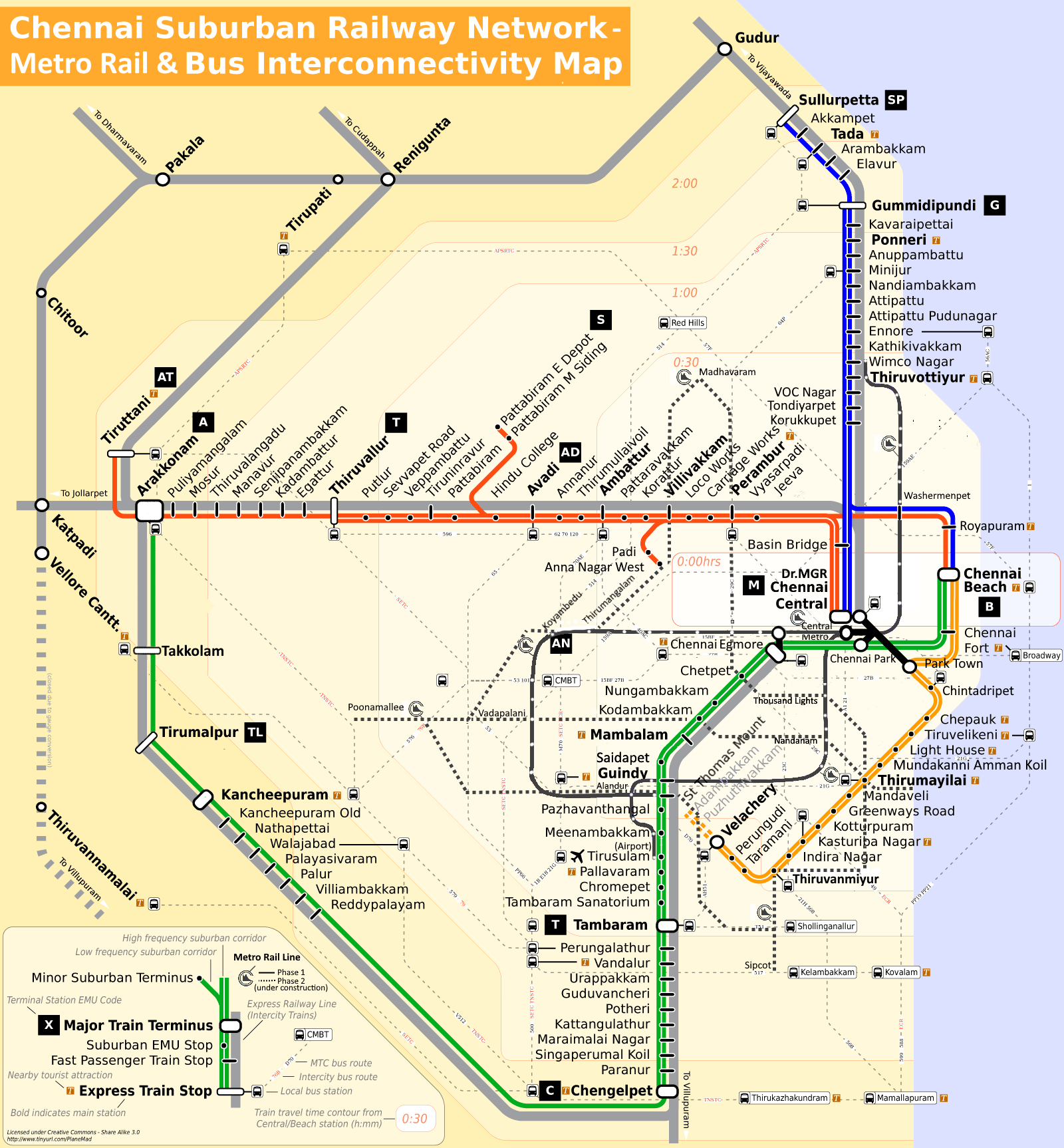
The Chennai Suburban Railway is a commuter rail system in the city of Chennai, Tamil Nadu, India, operated by the Southern Railways branch of Indian Railways. It is the second largest suburban rail network in terms of route length and the third largest in terms of commuters in India. Around 1,000 services are operated daily between 4:00 a.m. and midnight. It is the longest suburban circular route in India covering of . Chennai has a complex railway network. It is the third busiest suburban rail system in India after Mumbai and Kolkata. It has separate tracks for local and express trains. The system uses electrical multiple units (EMUs) operating on alternating current (AC) drawn from overhead wires through the catenary system. The total system spans around of which only have dedicated dual tracks for suburban EMUs, the rest share tracks with other trains and are called mainline EMUs (MEMUs). As of 2013, the suburban sector has 1,000 services, including 250 in the Beach†... [...More Info...] [...Related Items...] OR: [Wikipedia] [Google] [Baidu] |
Potheri
Potheri is a rapidly-growing village locality in the South suburbs of the Metropolitan city Chennai. It is a town that comes under Maraimalai Nagar municipality of Chengalpattu taluk in the Chengalpattu district of Tamil Nadu, India and suburb of Chennai within Chennai Metropolitan Area. It is about 2.5 kilometers from Guduvancheri.The primary educational institutions located in Potheri are SRM Institute of Science and Technology and Valliammai Engineering College. The neighbourhood is served by the Potheri railway station Chengalpattu taluk to Chennai Suburban Railway Network. The population of Potheri is primarily composed of students from the educational institutions located in Potheri. The socioeconomic status of the village almost entirely depends upon the SRM Institute of Science and Technology. Most of the population of Potheri live in apartment buildings. Transportation Potheri is located in the southern part of the Chennai city and is well-connected by roads and ra ... [...More Info...] [...Related Items...] OR: [Wikipedia] [Google] [Baidu] |
SRM Institute Of Science And Technology
SRM Institute of Science and Technology (SRMIST), formerly SRM University, is a private higher education institute deemed to be university, located in Kattankulathur, Chengalpattu (near Chennai), Tamil Nadu, India. Founded in 1985 as SRM Engineering College in Kattankulathur, it gained the deemed status in 2002. SRM Institute of Science and Technology includes six campuses, four in Tamil Nadu — Kattankulathur, Ramapuram and Vadapalani, and Tiruchirappalli, one in Andhra Pradesh — Amaravati, and one in NCR Delhi. History The first college of what is now SRMIST, SRM Engineering College, was established in 1985, followed by the rest of the SRM colleges in 1992 to 1997. The institute gained deemed status in 2002 as SRM Institute of Science and Technology and renamed SRM University in 2006. In 2017, it was renamed back to SRM Institute of Science and Technology following the UGC request to drop "University" from the name. Campuses Kattankulathur campus Located about away f ... [...More Info...] [...Related Items...] OR: [Wikipedia] [Google] [Baidu] |


