|
Manzanar, California
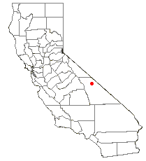
Manzanar (Spanish for "apple orchard") was a town in Inyo County, California, founded by water engineer and land developer George Chaffey. It was situated on the former narrow-gauge railway line of the Southern Pacific Railroad north of Lone Pine, California, Lone Pine, at an elevation of . A post office operated at Manzanar from 1911 to 1914. Manzanar was a shipping point for the surrounding apple orchards before the diversion of water through the Los Angeles Aqueduct from the Owens Valley to Los Angeles, California, Los Angeles. During World War II, the area was the location of the Manzanar War Relocation Center, where people of Japanese ancestry were held. Owens Valley Paiute Manzanar was first inhabited by Native Americans in the United States, Native Americans nearly 10,000 years ago. Approximately 1,500 years ago, the area was settled by the Owens Valley Paiute, who ranged across the Owens Valley from Long Valley Caldera, Long Valley on the north to Owens Lake on the so ... [...More Info...] [...Related Items...] OR: [Wikipedia] [Google] [Baidu] |
California
California is a U.S. state, state in the Western United States, located along the West Coast of the United States, Pacific Coast. With nearly 39.2million residents across a total area of approximately , it is the List of states and territories of the United States by population, most populous U.S. state and the List of U.S. states and territories by area, 3rd largest by area. It is also the most populated Administrative division, subnational entity in North America and the 34th most populous in the world. The Greater Los Angeles area and the San Francisco Bay Area are the nation's second and fifth most populous Statistical area (United States), urban regions respectively, with the former having more than 18.7million residents and the latter having over 9.6million. Sacramento, California, Sacramento is the state's capital, while Los Angeles is the List of largest California cities by population, most populous city in the state and the List of United States cities by population, ... [...More Info...] [...Related Items...] OR: [Wikipedia] [Google] [Baidu] |
Mono Tribe
The Mono ( ) are a Native American people who traditionally live in the central Sierra Nevada, the Eastern Sierra (generally south of Bridgeport), the Mono Basin, and adjacent areas of the Great Basin. The Eastern mono is often grouped under the historical label "Paiute" together with the Northern Paiute and Southern Paiute - They speak dialects of Mono a Numic .language closely Related to Northern Paiute and Bannock . The Eastern Mono Was renamed to Owens valley Paiute and Are now considered a Northern paiute people that speak the Eastern Mono Language with multiple dialects in the Owens Valley. Today, many of the tribal citizens and descendants of the Mono tribe inhabit the town of North Fork (thus the label "Northfork Mono") in Madera County. People of the Mono tribe are also spread across California .The Formerly known Eastern mono in the Owens River Valley are known as Owens Valley Paiute due to there close relation with the Northern Paiutes of Nevada .The western mono ar ... [...More Info...] [...Related Items...] OR: [Wikipedia] [Google] [Baidu] |
Kearsarge, California
Kearsarge (formerly, Kearsarge Station and Citrus) is an unincorporated community in Inyo County, California in the Owens Valley. It is located on the former route of the Southern Pacific Railroad east of Independence Independence is a condition of a person, nation, country, or state in which residents and population, or some portion thereof, exercise self-government, and usually sovereignty, over its territory. The opposite of independence is the statu ..., at an elevation of . Citrus post office operated from 1888 to 1905 and from 1907 to 1910. References External links * Unincorporated communities in California Unincorporated communities in Inyo County, California Populated places in the Mojave Desert {{InyoCountyCA-geo-stub ... [...More Info...] [...Related Items...] OR: [Wikipedia] [Google] [Baidu] |
Independence, California
Independence is a census-designated place in Inyo County, California. Independence is located south-southeast of Bishop, at an elevation of 3930 feet (1198 m). It is the county seat of Inyo County, California. The population of this census-designated place was 669 at the 2010 census, up from 574 at the 2000 census. Geography The small town of Independence is bisected by U.S. Route 395, the main north-south highway through the Owens Valley. The Sierra Nevada mountains to the west lie within the John Muir Wilderness Area. Onion Valley, one of the principal entry routes to the John Muir Wilderness, is accessed via the Onion Valley road which heads directly west out of Independence. This trail takes hikers to Kings Canyon/ Sequoia National Parks which protect the Sierra Nevada west of the divide between the Owens Valley on the east and the rivers which drain into the San Joaquin Valley to the west. Independence is a popular resupply location for hikers trekking the 2,650 mile ... [...More Info...] [...Related Items...] OR: [Wikipedia] [Google] [Baidu] |
Board Of Supervisors
A board of supervisors is a governmental body that oversees the operation of county government in the U.S. states of Arizona, California, Iowa, Mississippi, Virginia, and Wisconsin, as well as 16 counties in New York. There are equivalent agencies in other states. Similar to a city council, a board of supervisors has legislative, executive, and quasi-judicial powers. The important difference is that a county is an administrative division of a state, whereas a city is a municipal corporation; thus, counties implement and, as necessary, refine the local application of state law and public policy, while cities produce and implement their own local laws and public policy (subject to the overriding authority of state law). Often they are concerned with the provision of courts, jails, public health and public lands. Legislative powers Boards may pass and repeal laws, generally called ''ordinances''. Depending on the state, and the subject matter of the law, these laws may apply to ... [...More Info...] [...Related Items...] OR: [Wikipedia] [Google] [Baidu] |
Southern Pacific Transportation Company
The Southern Pacific (or Espee from the railroad initials- SP) was an American Class I railroad network that existed from 1865 to 1996 and operated largely in the Western United States. The system was operated by various companies under the names Southern Pacific Railroad, Southern Pacific Company and Southern Pacific Transportation Company. The original Southern Pacific began in 1865 as a land holding company. The last incarnation of the Southern Pacific, the Southern Pacific Transportation Company, was founded in 1969 and assumed control of the Southern Pacific system. The Southern Pacific Transportation Company was acquired in 1996 by the Union Pacific Corporation and merged with their Union Pacific Railroad. The Southern Pacific legacy founded hospitals in San Francisco, Tucson, and Houston. In the 1970s, it also founded a telecommunications network with a state-of-the-art microwave and fiber optic backbone. This telecommunications network became part of Sprint, a compa ... [...More Info...] [...Related Items...] OR: [Wikipedia] [Google] [Baidu] |
Southern California
Southern California (commonly shortened to SoCal) is a geographic and Cultural area, cultural region that generally comprises the southern portion of the U.S. state of California. It includes the Los Angeles metropolitan area, the second most populous urban agglomeration in the United States. The region generally contains ten of California's 58 counties: Imperial County, California, Imperial, Kern County, California, Kern, Los Angeles County, California, Los Angeles, Orange County, California, Orange, Riverside County, California, Riverside, San Bernardino County, California, San Bernardino, San Diego County, California, San Diego, Santa Barbara County, California, Santa Barbara, San Luis Obispo County, California, San Luis Obispo and Ventura County, California, Ventura counties. The Colorado Desert and the Colorado River are located on Southern California's eastern border with Arizona, and San Bernardino County shares a border with Nevada to the northeast. Southern California's ... [...More Info...] [...Related Items...] OR: [Wikipedia] [Google] [Baidu] |
Winesaps
Winesap is an old apple cultivar of unknown origin, dating at least to American colonial times. Its apples are sweet with a tangy finish. They are used for eating, cooking, and are especially prized for making cider. albermarleciderworks.com Winesap "Winesap was first described as a cider fruit by Dr. James Mease in Philadelphia in 1804, and in 1817, William Coxe illustrated and described it in A View of the Cultivation of Fruit Trees. It was known during the colonial period in Virginia, and Coxe wrote of it as popular for cider making in New Jersey.... A dependable bearer, it produces heavy crops annually and is suitable for cooking, dessert and cider making." History Although the particular origin of the Winesap is not clear, authors note that it was known during the Colonial period and is thought to have come from New ...[...More Info...] [...Related Items...] OR: [Wikipedia] [Google] [Baidu] |
European American
European Americans (also referred to as Euro-Americans) are Americans of European ancestry. This term includes people who are descended from the first European settlers in the United States as well as people who are descended from more recent European arrivals. European Americans have been the largest panethnic group in the United States since about the 17th century. The Spaniards are thought to be the first Europeans to establish a continuous presence in what is now the contiguous United States, with Martín de Argüelles ( 1566) in St. Augustine, then a part of Spanish Florida, and the Russians were the first Europeans to settle in Alaska, establishing Russian America. The first English child born in the Americas was Virginia Dare, born August 18, 1587. She was born in Roanoke Colony, located in present-day North Carolina, which was the first attempt, made by Queen Elizabeth I, to establish a permanent English settlement in North America. In the 2016 American Commun ... [...More Info...] [...Related Items...] OR: [Wikipedia] [Google] [Baidu] |
Saline Valley
Saline Valley is a large, deep, and arid graben, about in length, in the northern Mojave Desert of California, a narrow, northwest–southeast-trending tectonic sink defined by fault-block mountains. Most of it became a part of Death Valley National Park when the park was expanded in 1994. This area had previously been administered by the Bureau of Land Management. It is located northwest of Death Valley proper, south of Eureka Valley, and east of the Owens Valley. The valley's lowest elevations are about and it lies in the rain shadow of the Sierra Nevada range, plus the Inyo Mountains bordering the valley on the west. Natural features A large dry lake occupies the center of the valley. The west end of the lake supports a salt marsh, which contains a variety of plant and animal life. The marsh is fed by a perennial stream from Hunter Canyon. North of the lake is a large area of low and sweeping sand dunes. There are a number of hot springs in the northeast corner of th ... [...More Info...] [...Related Items...] OR: [Wikipedia] [Google] [Baidu] |


