|
Mantle Plume
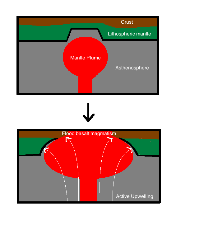
A mantle plume is a proposed mechanism of convection within the Earth's mantle, hypothesized to explain anomalous volcanism. Because the plume head partially melts on reaching shallow depths, a plume is often invoked as the cause of volcanic hotspots, such as Hawaii or Iceland, and large igneous provinces such as the Deccan and Siberian Traps. Some such volcanic regions lie far from tectonic plate boundaries, while others represent unusually large-volume volcanism near plate boundaries. Concepts Mantle plumes were first proposed by J. Tuzo Wilson in 1963 and further developed by W. Jason Morgan in 1971 and 1972. A mantle plume is posited to exist where super-heated material forms ( nucleates) at the core-mantle boundary and rises through the Earth's mantle. Rather than a continuous stream, plumes should be viewed as a series of hot bubbles of material. Reaching the brittle upper Earth's crust they form diapirs. These diapirs are "hotspots" in the crust. In particular, the conc ... [...More Info...] [...Related Items...] OR: [Wikipedia] [Google] [Baidu] |
Iceland Hotspot
The Iceland hotspot is a hotspot which is partly responsible for the high volcanic activity which has formed the Iceland Plateau and the island of Iceland. Iceland is one of the most active volcanic regions in the world, with eruptions occurring on average roughly every three years (in the 20th century there were 39 volcanic eruptions on and around Iceland). About a third of the basaltic lavas erupted in recorded history have been produced by Icelandic eruptions. Notable eruptions have included that of Eldgjá, a fissure of Katla, in 934 (the world's largest basaltic eruption ever witnessed), Laki in 1783 (the world's second largest), and several eruptions beneath ice caps, which have generated devastating glacial bursts, most recently in 2010 after the eruption of Eyjafjallajökull. Iceland's location astride the Mid-Atlantic Ridge, where the Eurasian and North American Plates are moving apart, is partly responsible for this intense volcanic activity, but an additional c ... [...More Info...] [...Related Items...] OR: [Wikipedia] [Google] [Baidu] |
Large Low-shear-velocity Provinces
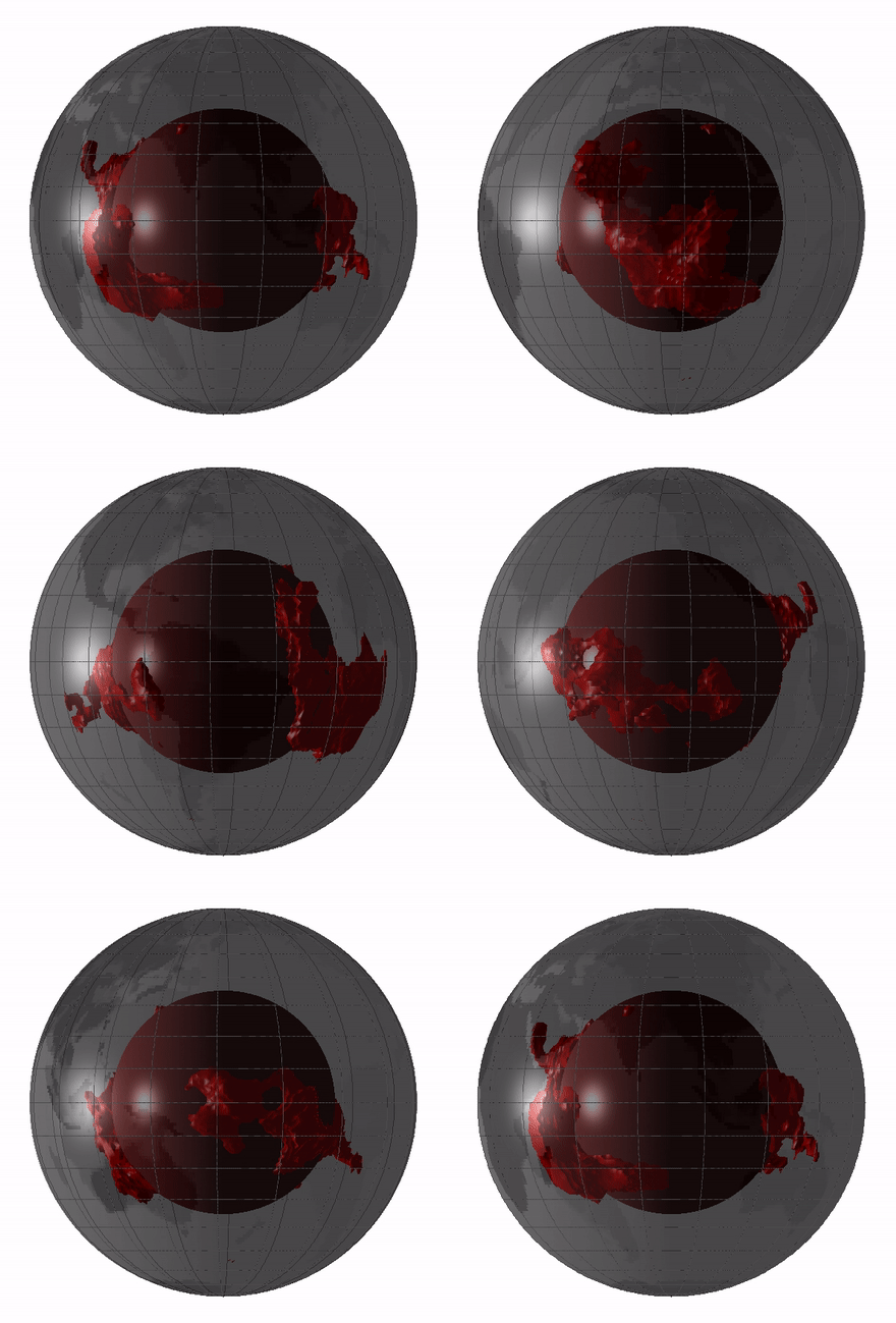
Large low-shear-velocity provinces, LLSVPs, also called LLVPs or superplumes, are characteristic structures of parts of the lowermost mantle (the region surrounding the outer core) of Earth. These provinces are characterized by slow shear wave velocities and were discovered by seismic tomography of deep Earth. There are two main provinces: the African LLSVP and the Pacific LLSVP. Both extend laterally for thousands of kilometers and possibly up to vertically from the core–mantle boundary. The Pacific LLSVP is across, and underlies four hotspots that suggest multiple mantle plumes underneath. These zones represent around 8% of the volume of the mantle (6% of Earth). Other names for LLSVPs include " superswells", "thermo-chemical piles", or "hidden reservoirs". Most of these names, however, are more interpretive of their proposed geodynamical or geochemical effects. For example, the name "thermo-chemical pile" interprets LLSVPs as lower-mantle piles of thermally hot and/or chemi ... [...More Info...] [...Related Items...] OR: [Wikipedia] [Google] [Baidu] |
Ontong Java Plateau
The Ontong Java Plateau (OJP) is a massive oceanic plateau located in the southwestern Pacific Ocean, north of the Solomon Islands. The OJP was formed around (Ma) with a much smaller volcanic event around 90 Ma. Two other southwestern Pacific plateaus, Manihiki and Hikurangi, now separated from the OJP by Cretaceous oceanic basins, are of similar age and composition and probably formed as a single plateau and a contiguous large igneous province together with the OJP. When eruption of lava had finished, the Ontong Java–Manihiki–Hikurangi plateau covered 1% of Earth's surface and represented a volume of of basaltic magma. This "Ontong Java event", first proposed in 1991, represents the largest volcanic event of the past 200 million years, with a magma eruption rate estimated at up to per year over 3 million years, several times larger than the Deccan Traps. The smooth surface of the OJP is punctuated by seamounts such as the Ontong Java Atoll, one of the largest atolls ... [...More Info...] [...Related Items...] OR: [Wikipedia] [Google] [Baidu] |
Columbia River Basalts
The Columbia River Basalt Group is the youngest, smallest and one of the best-preserved continental flood basalt province on Earth, covering over mainly eastern Oregon and Washington, western Idaho, and part of northern Nevada. The basalt group includes the Steens and Picture Gorge basalt formations. Introduction During the middle to late Miocene epoch, the Columbia River flood basalts engulfed about of the Pacific Northwest, forming a large igneous province with an estimated volume of . Eruptions were most vigorous 17–14 million years ago, when over 99 percent of the basalt was released. Less extensive eruptions continued 14–6 million years ago. Erosion resulting from the Missoula Floods has extensively exposed these lava flows, laying bare many layers of the basalt flows at Wallula Gap, the lower Palouse River, the Columbia River Gorge and throughout the Channeled Scablands. The Columbia River Basalt Group is thought to be a potential link to the Chilc ... [...More Info...] [...Related Items...] OR: [Wikipedia] [Google] [Baidu] |
Paraná And Etendeka Traps
The Paraná-Etendeka traps (or Paraná and Etendeka Plateau; or Paraná and Etendeka Province) comprise a large igneous province that includes both the main Paraná traps (in Paraná Basin, a South American geological basin) as well as the smaller severed portions of the flood basalts at the Etendeka traps (in northwest Namibia and southwest Angola). The original basalt flows occurred 138 to 128 million years ago. The province had a post-flow surface area of and an original volume projected to be in excess of 2.3 x 10⁶ km³. Geodynamics The basalt samples at Paraná and Etendeka have an age of about 132 Ma, during the Valanginian stage of the Early Cretaceous. Indirectly, the rifting and extension are probably the origin of the Paraná and Etendeka traps and it could be the origin of the Gough and Tristan da Cunha Islands as well, as they are connected by the Walvis Ridge (Gough/Tristan hotspot). The seamounts of the Rio Grande Rise (25°S to 35°S) that go eastwards fro ... [...More Info...] [...Related Items...] OR: [Wikipedia] [Google] [Baidu] |
Karoo-Ferrar
The Karoo and Ferrar Large Igneous Provinces (LIPs) are two large igneous provinces in Southern Africa and Antarctica respectively, collectively known as the Karoo-Ferrar, Gondwana,E.g. or Southeast African LIP, associated with the initial break-up of the Gondwana supercontinent at . Its flood basalt mostly covers South Africa and Antarctica but portions extend further into southern Africa and into South America, India, Australia and New Zealand. Karoo-Ferrar formed just prior to the breakup of Gondwana in the Lower Jurassic epoch, about 183 million years ago; this timing corresponds to the early Toarcian anoxic event and the Pliensbachian-Toarcian extinction. It covered about 3 x 10⁶ km2. The total original volume of the flow, which extends over a distance in excess of 6000 km (4000 km in Antarctica alone), was in excess of 2.5 x 10⁶ km³ (2.5 million cubic kilometres). The Ferrar LIP is notable for long distance transport and the Karoo LIP for its large volume and c ... [...More Info...] [...Related Items...] OR: [Wikipedia] [Google] [Baidu] |
Siberian Traps
The Siberian Traps (russian: Сибирские траппы, Sibirskiye trappy) is a large region of volcanic rock, known as a large igneous province, in Siberia, Russia. The massive eruptive event that formed the trap rock, traps is one of the largest known Volcano, volcanic events in the last years. The eruptions continued for roughly two million years and spanned the Permian–Triassic boundary, or P–T boundary, which occurred around 251.9 million years ago. The Siberian Traps are believed to be the primary cause of the Permian–Triassic extinction event, the most severe extinction event in the geologic record."New Studies of Permian Extinction Shed Light On the Great Dying" New York Times, April 30, 2012. Retrieved ... [...More Info...] [...Related Items...] OR: [Wikipedia] [Google] [Baidu] |
Deccan Traps
The Deccan Traps is a large igneous province of west-central India (17–24°N, 73–74°E). It is one of the largest volcanic features on Earth, taking the form of a large shield volcano. It consists of numerous layers of solidified flood basalt that together are more than about thick, cover an area of about , and have a volume of about . Originally, the Deccan Traps may have covered about ,"What really killed the dinosaurs?" Jennifer Chu, MIT News Office, 11 December 2014 with a correspondingly larger original volume. This volume overlies the age |
Flood Basalt
A flood basalt (or plateau basalt) is the result of a giant volcanic eruption or series of eruptions that covers large stretches of land or the ocean floor with basalt lava. Many flood basalts have been attributed to the onset of a hotspot reaching the surface of the earth via a mantle plume. Flood basalt provinces such as the Deccan Traps of India are often called '' traps'', after the Swedish word ''trappa'' (meaning "staircase"), due to the characteristic stairstep geomorphology of many associated landscapes. Michael R. Rampino and Richard Stothers (1988) cited eleven distinct flood basalt episodes occurring in the past 250 million years, creating large igneous provinces, lava plateaus, and mountain ranges. However, more have been recognized such as the large Ontong Java Plateau, and the Chilcotin Group, though the latter may be linked to the Columbia River Basalt Group. Large igneous provinces have been connected to five mass extinction events, and may be associated with b ... [...More Info...] [...Related Items...] OR: [Wikipedia] [Google] [Baidu] |
Heat Flux
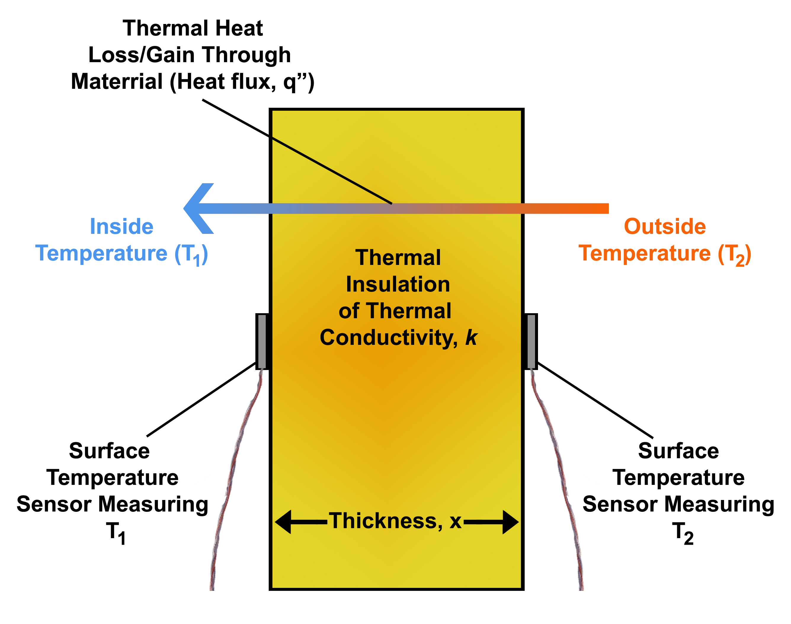
Heat flux or thermal flux, sometimes also referred to as ''heat flux density'', heat-flow density or ''heat flow rate intensity'' is a flow of energy per unit area per unit time. In SI its units are watts per square metre (W/m2). It has both a direction and a magnitude, and so it is a vector quantity. To define the heat flux at a certain point in space, one takes the limiting case where the size of the surface becomes infinitesimally small. Heat flux is often denoted \vec_\mathrm, the subscript specifying ''heat'' flux, as opposed to ''mass'' or ''momentum'' flux. Fourier's law is an important application of these concepts. Fourier's law For most solids in usual conditions, heat is transported mainly by conduction and the heat flux is adequately described by Fourier's law. Fourier's law in one dimension \phi_\text = -k \frac where k is the thermal conductivity. The negative sign shows that heat flux moves from higher temperature regions to lower temperature regions. ... [...More Info...] [...Related Items...] OR: [Wikipedia] [Google] [Baidu] |
Scientific Modelling
Scientific modelling is a scientific activity, the aim of which is to make a particular part or feature of the world easier to understand, define, quantify, visualize, or simulate by referencing it to existing and usually commonly accepted knowledge. It requires selecting and identifying relevant aspects of a situation in the real world and then developing a model to replicate a system with those features. Different types of models may be used for different purposes, such as conceptual models to better understand, operational models to operationalize, mathematical models to quantify, computational models to simulate, and graphical models to visualize the subject. Modelling is an essential and inseparable part of many scientific disciplines, each of which has its own ideas about specific types of modelling. The following was said by John von Neumann. There is also an increasing attention to scientific modelling in fields such as science education, philosophy of science, ... [...More Info...] [...Related Items...] OR: [Wikipedia] [Google] [Baidu] |


