|
Mandangad
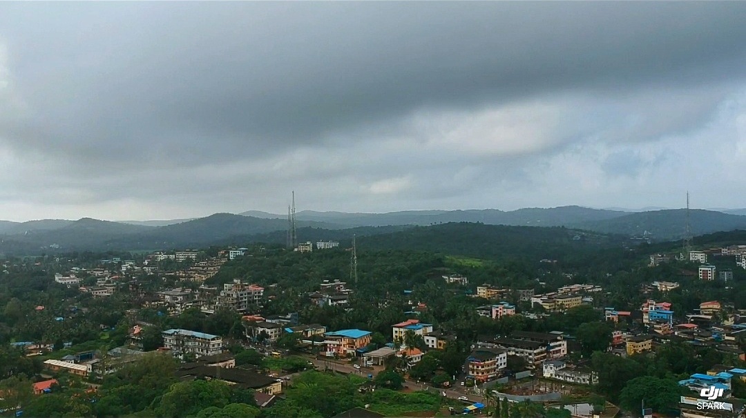
Mandangad (or Mandangadh or Mandangarh) is the headquarters of Mandangad taluka the northmost taluka in Ratnagiri district of Maharashtra, India. Description Mandangad is the ''taluka'' (tehsil) headquarters in Ratnagiri district of Maharashtra state in India. The heart of Mandangad is Mandangad fort. The village is situated at the extreme north of Ratnagiri District. In terms of geographical features, its area is about 43,100 Hectares, altitude is 882 feet (268 metres), latitude 17.9833 and longitude 73.2500. Time zone is UTC+5.30. Average rainfall in the taluka is 3996 mm. Mandangad is a hilly coastal zone. Mandangad is 175 km from Ratnagiri, 170 km from Pune and 210 km from Mumbai. It is connected by road. The nearest major town is Mangaon in Raigad District on Mumbai-Goa National Highway No. 66 . The Arabian Sea is about 35 km from Mandangad. History Overlooking the small town of Mandangad is a two-peaked hill fort also known by the ... [...More Info...] [...Related Items...] OR: [Wikipedia] [Google] [Baidu] |
Mandangad Fort
Mandangad Fort (also called Chitradurga Fort) is about 2 km from Mandangad town in Ratnagiri District, Maharashtra. This fort is said to be constructed by King Bhoj. After the Mughals lost the Battle of Umberkhind , This fort was captured by Shivaji in the battle with Adil Shah. A 400-year-old cannon is the major feature of the fort. The fort constitutes a Ganapati Temple and a tank called Thorla Talav. It consists of three separate fortifications - Mandangad proper to the south, Parkot in the middle while Jamba in the north. The Jamba water reservoir is now dry. Even though they are believed be much older, local legend attributes Mandangad to Shivaji, Parkot to Habshi of the Siddi The Siddi (), also known as the Sheedi, Sidi, or Siddhi, or Habshi are an ethnic group inhabiting India and Pakistan. They are primarily descended from the Bantu peoples of the Zanj coast in Southeast Africa and Ethiopia, most whom arrived to ...s and Jamba to Kanhoji Angre(also call ... [...More Info...] [...Related Items...] OR: [Wikipedia] [Google] [Baidu] |
Babasaheb Ambedkar
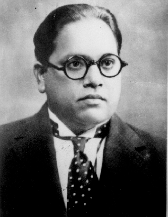
Bhimrao Ramji Ambedkar (14 April 1891 – 6 December 1956) was an Indian jurist, economist, social reformer and political leader who headed the committee drafting the Constitution of India from the Constituent Assembly debates, served as Law and Justice minister in the first cabinet of Jawaharlal Nehru, and inspired the Dalit Buddhist movement after renouncing Hinduism. Ambedkar graduated from Elphinstone College, University of Bombay, and studied economics at Columbia University and the London School of Economics, receiving doctorates in 1927 and 1923 respectively and was among a handful of Indian students to have done so at either institution in the 1920s. He also trained in the law at Gray's Inn, London. In his early career, he was an economist, professor, and lawyer. His later life was marked by his political activities; he became involved in campaigning and negotiations for India's independence, publishing journals, advocating political rights and social freedo ... [...More Info...] [...Related Items...] OR: [Wikipedia] [Google] [Baidu] |
Bholavali
Bholavali is a small village in Mandangad, Ratnagiri district, Maharashtra state in Western India. The 2011 Census of India recorded a total of 823 residents in the village. Post Office: Latwan. Nearest Railway station: Karanjadi railway station. Bholavali's geographical area is . Places to visit: 1. BHOLAVALI'S dam 2. Devacha Dongar 3. Kalbacha Deul (Temple) Cluster(Wadi) 1. Khalcha Kond 2. Katal Wadi 3. Faujdar Kond 4. Bouddha Wadi 5. Rane Wadi(फड) 6. Devul Kond 7. Gaval Waddi 8. Bhend wadi 9. Mane wadi 10.Varcha kond References {{reflist, refs= {{cite web , url=http://www.censusindia.gov.in/2011census/dchb/2732_PART_B_DCHB_RATNAGIRI.pdf , title=District Census Handbook , publisher=Census of India The decennial Census of India has been conducted 16 times, as of 2021. While it has been undertaken every 10 years, beginning in 1872 under British Viceroy Lord Mayo, the first complete census was taken in 1881. Post 1949, it has been conducted by ... , accessdat ... [...More Info...] [...Related Items...] OR: [Wikipedia] [Google] [Baidu] |
Ambadawe
Ambadawe is a village in the Mandangad taluk of Ratnagiri district in Maharashtra, India. This village is family origin of B. R. Ambedkar, Architect of constitution of India. Census data Notable people * The family A family is a domestic or social group. Family or The Family may also refer to: Mathematics *Family of curves, a set of curves resulting from a function with variable parameters *Family of sets, a collection of sets *Indexed family, a family wh ... origins of B. R. Ambedkar, the Indian jurist, politician, and social reformer from Maharashtra is from this village. His original surname was ''Sakpal'' but his father registered his name to school in ''Ambadawekar'', which comes from this native village name 'Ambadawe'. References External links Villages in Ratnagiri district {{Ratnagiri-geo-stub ... [...More Info...] [...Related Items...] OR: [Wikipedia] [Google] [Baidu] |
Mandangad Taluka
Mandangad taluka is a taluka in Ratnagiri district of Maharashtra an Indian state. Ratnagiri district There are nine talukas in Ratnagiri district, they are Ratnagiri, Rajapur, Lanja, Sangmeshwar, Chiplun, Guhagar Guhagar (Marathi pronunciation: �uɦaːɡəɾ is a census town in Ratnagiri district in the Indian state of Maharashtra. Guhagar is known for its virgin beach, coir items, coconuts, betel nuts and mainly Alphonso mangoes. The nearest city ..., Khed, Dapoli and Mandangad. See also * Devhare References Talukas in Ratnagiri district {{Ratnagiri-geo-stub ... [...More Info...] [...Related Items...] OR: [Wikipedia] [Google] [Baidu] |
Dhutroli
Dhutroli is a small village in Mandangad, Ratnagiri district, Maharashtra state in Western India. The 2011 Census of India The 2011 Census of India or the 15th Indian Census was conducted in two phases, house listing and population enumeration. The House listing phase began on 1 April 2010 and involved the collection of information about all buildings. Information ... recorded a total of 1,049 residents in the village. Dhutroli's geographical area is . References {{coord missing, Maharashtra Villages in Ratnagiri district ... [...More Info...] [...Related Items...] OR: [Wikipedia] [Google] [Baidu] |
Devhare Keril
Devhare is in Mandangad taluka Mandangad taluka is a taluka in Ratnagiri district of Maharashtra an Indian state. Ratnagiri district There are nine talukas in Ratnagiri district, they are Ratnagiri, Rajapur, Lanja, Sangmeshwar, Chiplun, Guhagar Guhagar (Marathi pronun ... about 210 km from Mumbai by road. All state transport buses go through the Devhare. Devhare is scenic and surrounded with hills. The normal temperature of Devhare is around 26 °C. In month of April and may go around 42 degrees. Devhare is relatively undiscovered as a tourist destination. The Scenic beach of Kelshi is about 15 km from Devhare. A ferry from Bankot can take you to Harihareshwar and Shriwardhan, the ferry ride is very scenic. Marathi is the common language here. Some people also know Hindi and English. All the festivals are celebrated with great enthusiasm and a spirit of togetherness. Gauri Ganapati and Magh Chaturthi are the most important events in the en ... [...More Info...] [...Related Items...] OR: [Wikipedia] [Google] [Baidu] |
Dahagaon
Dahagaon is a small village located in Mandangad, Ratnagiri district, Maharashtra state in Western India. The 2011 Census of India The 2011 Census of India or the 15th Indian Census was conducted in two phases, house listing and population enumeration. The House listing phase began on 1 April 2010 and involved the collection of information about all buildings. Information ... recorded a total of 1,361 residents in the village. Dahagaon's geographical area is . References {{coord, 19, 37, N, 77, 40, E, display=title, region:IN_type:city_source:GNS-enwiki Villages in Ratnagiri district ... [...More Info...] [...Related Items...] OR: [Wikipedia] [Google] [Baidu] |
Bankot
Bankot is a town in Maharashtra, India. It became part of the Bombay Presidency in 1756. Its most famous structure is Bankot Fort, which was the first residency of the British Raj in Southern Konkan. Business Mango is one of the most important crops of this village, and mango trees occupy about 60 per-cent of the land used to cultivate fruit. Hill-slopes near the coast where drainage is assured and climatic conditions are ideal, present the most suitable site for mango cultivation. Cashew, Cashew nut stands next in importance to mango and occupies nearly one-third of the area used to cultivate fruit. Banana and coconut are grown on a smaller scale. Sand dredging and mining have been major businesses since the 20th century. Schools 1.German Parkar High School (Urdu) 2.Dr. A. R. Undre High School (English) 3.Undre college of commerce (English) There are two kindergartens (Bal-wadi) for local kids (Urdu medium and Marathi medium. Literacy in Bankot is almost 99% Climate The ... [...More Info...] [...Related Items...] OR: [Wikipedia] [Google] [Baidu] |
Ratnagiri District
Ratnagiri District (Marathi pronunciation: �ət̪n̪aːɡiɾiː is a district in the state of Maharashtra, India. The administrative headquarter of the district is located in the town of Ratnagiri. The district is 11.33% urban. The district is bounded by the Arabian Sea to the west, Sindhudurg district to the south, Raigad district to the north and Satara, Sangli and Kolhapur districts to the east. This district is part of Konkan division. Officer Members of Parliament *Sunil Tatkare (NCP) - Raigad Vinayak Raut ( SHS (UBT)) Guardian Minister list of Guardian Minister District Magistrate/Collector list of District Magistrate / Collector History From pre-Christian times until 1312, the area - like the entire region - was ruled by various Buddhist and Hindu rulers. The first state known by name was the Maurya Empire, the last non-Muslim dynasty were the Yadavas of Devagiri. After decades of military clashes with Muslim rulers in northern India, it was occupied ... [...More Info...] [...Related Items...] OR: [Wikipedia] [Google] [Baidu] |
Palgadh
Palgadh is a village in Dapoli taluka, Ratnagiri district, Maharashtra state, India, between Mandangadh and Khed, best known as the boyhood home of Pandurang Sadashiv Sane Pandurang Sadashiv Sane ( mar, पांडुरंग सदाशिव साने; ; 24 December 1899 – 11 June 1950), also known as ''Sane Guruji'' (Guruji meaning "respected teacher") by his students and followers, was a Marathi autho .... Villages in Ratnagiri district {{Ratnagiri-geo-stub ... [...More Info...] [...Related Items...] OR: [Wikipedia] [Google] [Baidu] |
Dapoli
Dapoli is a town in Ratnagiri district, Maharashtra which is also a coastal hill station. It lies south of the state capital of Mumbai. the town is also known as Camp Dapoli, as the British had set their camps here. Many high-ranking British officers' graves are found in this town. There is also an abandoned church from the time of the British Raj. Dapoli is administered by a Municipal Council. Geography Dapoli is separated from the Sahyadri range and is bordered by the Khed taluk in the east, and is also bordered by Mandangad taluk in the north, Guhagar taluk to the south, and Chiplun taluk to the southeast. The Arabian sea forms the sub-district's western border. Dapoli has a seaboard of which stretches from Velas, Maharashtra Velas - Kelshi in the North to Dabhol in the South. The coastline differs in its general characteristics from other parts of Konkan. It is densely covered by coconut farms. The principal rivers arBharjain the north and Vashishthi in the south. ... [...More Info...] [...Related Items...] OR: [Wikipedia] [Google] [Baidu] |


