|
Malakhi Junction
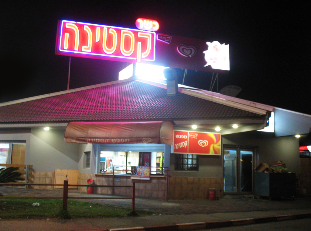
The Malakhi Junction, also known as Qastina ( he, קסטינה) for the Arab village which once stood there, is a major road junction in Israel, between Highway 40 (Israel), Highway 40 and Highway 3 (Israel), 3. It is located on the 37th kilometer of Highway 3. Like most junctions in Israel, it serves as a major transportation hub and has a trempiada, or hitchhiking stand. Due to its proximity to Kiryat Malakhi, it is also sometimes considered Kiryat Malakhi's central bus station, operated by the Be'er Tuvia Regional Council. In that capacity however, it has been often criticized, to the point that Ynet uses a photo of the bus stations in Qastina as a stock photo for public transportation critiques. In a March 2007 survey, Ynet gave Qastina a 0/10 rating (the lowest) out of 11 bus station checked nationwide. On March 1, 2008, the Israeli Channel 2 (Israel), Channel 2 ran a similar survey, ranking Qastina lowest, with 0/3 on its three main criteria. In addition, the junction is a co ... [...More Info...] [...Related Items...] OR: [Wikipedia] [Google] [Baidu] |
Qastina Night
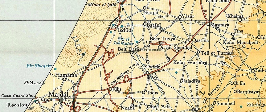
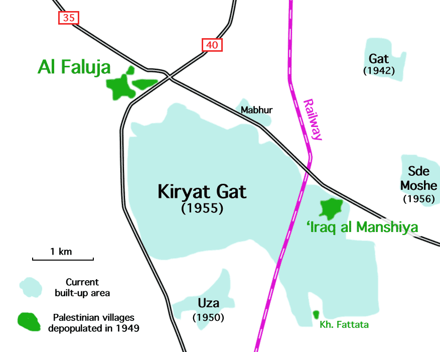
Qastina ( ar, قسطينة) was a Palestinian village, located 38 kilometers northeast of Gaza City. It was depopulated during the 1948 Arab-Israeli war. Location Qastina was situated on an elevated spot in a generally flat area on the coastal plain, on the highway between al-Majdal and the Jerusalem-Jaffa highway. A British military camp, Beer Tuvia, was 3 km. southwest of the village.Khalidi, 1992, pp. 130-131 History Ottoman period Qastina was incorporated into the Ottoman Empire in 1517 with the rest of Palestine, and by the 1596 tax records, it was a village in the ''nahiya'' (subdistrict) of Gaza under the ''liwa''' (district) of Gaza, with a population of 55 households and 15 bachelors, an estimated 385 persons. All the villagers were Muslim. They paid a fixed tax rate of 33,3% on a number of crops, including wheat, barley and sesame, and fruits, as well as goats, beehives and vineyards; a total of 13,100 akçe. 5/6 of the revenue went to a Muslim charitable endo ... [...More Info...] [...Related Items...] OR: [Wikipedia] [Google] [Baidu] |
Qastina Stops
Qastina ( ar, قسطينة) was a Palestinian village, located 38 kilometers northeast of Gaza City. It was depopulated during the 1948 Arab-Israeli war. Location Qastina was situated on an elevated spot in a generally flat area on the coastal plain, on the highway between al-Majdal and the Jerusalem-Jaffa highway. A British military camp, Beer Tuvia, was 3 km. southwest of the village.Khalidi, 1992, pp. 130-131 History Ottoman period Qastina was incorporated into the Ottoman Empire in 1517 with the rest of Palestine, and by the 1596 tax records, it was a village in the ''nahiya'' (subdistrict) of Gaza under the ''liwa''' (district) of Gaza, with a population of 55 households and 15 bachelors, an estimated 385 persons. All the villagers were Muslim. They paid a fixed tax rate of 33,3% on a number of crops, including wheat, barley and sesame, and fruits, as well as goats, beehives and vineyards; a total of 13,100 akçe. 5/6 of the revenue went to a Muslim charitable endo ... [...More Info...] [...Related Items...] OR: [Wikipedia] [Google] [Baidu] |
Yavne
Yavne ( he, יַבְנֶה) or Yavneh is a city in the Central District of Israel. In many English translations of the Bible, it is known as Jabneh . During Greco-Roman times, it was known as Jamnia ( grc, Ἰαμνία ''Iamníā''; la, Iamnia); to the Crusaders as Ibelin; and before 1948, as Yibna ( ar, يبنى). History Yavne was one of the major ancient cities in the southern coastal plain, situated south of Jaffa, north of Ashdod, and east of the Mediterranean.Moshe Fischer, Itamar Taxel and David AmitRural Settlement in the Vicinity of Yavneh in the Byzantine Period: A Religio-Archaeological Perspective Bulletin of the American Schools of Oriental Research, No. 350 (May, 2008), pp. 7-35. Excavations were carried out on the ancient tell (mound created by accumulation of archaeological remains) known as ''Tel Yavne'' (Hebrew), which developed on a natural kurkar_hill._The_tell_was_inhabited,_possibly_continuously,_from_either_the_Bronze_or_Iron_Age_until_the_Mandato ... [...More Info...] [...Related Items...] OR: [Wikipedia] [Google] [Baidu] |
Kiryat Gat
Kiryat Gat, also spelled Qiryat Gat ( he, קִרְיַת גַּת), is a city in the Southern District of Israel. It lies south of Tel Aviv, north of Beersheba, and from Jerusalem. In it had a population of . The city hosts one of the most advanced semiconductor fabrication plants in the world, Intel's Fab 28 plant producing 7 nm process chips and the currently under construction Fab 38 planned to open in 2024 and to produce 5 nm process using EUV lithography. Etymology Kiryat Gat is named for Gath, one of the five major cities of the Philistines. In Hebrew, "gat" means "winepress". In the 1950s, archaeologists found ruins at a nearby tell (Tel Erani) which were mistaken for the Philistine city of Gath. The location most favored for Gath now is Tel es-Safi, thirteen kilometers () to the northeast. History Kiryat Gat was founded in 1954, initially as a ma'abara. The following year it was established as a development town by 18 families from Morocco. It was founded just ... [...More Info...] [...Related Items...] OR: [Wikipedia] [Google] [Baidu] |
Gedera
Gedera, or less commonly known as Gdera ( he, גְּדֵרָה), is a town in the southern part of the Shfela region in the Central District of Israel founded in 1884. It is south of Rehovot. In , it had a population of . History Gedera is in the Book of Chronicles I 4:23 and the Book of Joshua 15:36 as a town in the territory of Judah. Its identification with the site of modern Gedera was proposed by Victor Guérin in the 19th century, but was dismissed as "impossible" by William F. Albright who preferred to identify it with al-Judeira. Biblical Gedera is now identified with Khirbet Judraya, south of Bayt Nattif. Tel Qatra, which lies at the northern edge of Gedera, is usually identified with Kedron, a place fortified by the Seleucids against the Hasmonaeans (1 Macc. 15:39-41, 16:9). It has also been identified with Gedrus, a large village in the time of Eusebius (fourth century). Eusebius identified Gedrus with biblical Gedor, which is a name also appearing on the ... [...More Info...] [...Related Items...] OR: [Wikipedia] [Google] [Baidu] |
Rehovot
Rehovot ( he, רְחוֹבוֹת ''Rəḥōvōt'', ar, رحوڤوت ''Reḥūfūt'') is a city in the Central District of Israel, about south of Tel Aviv. In it had a population of . Etymology Israel Belkind, founder of the Bilu movement, proposed the name "Rehovot" (lit. 'wide expanses') based on Genesis 26:22: "And he called the name of it ''Rehoboth''; and he said: 'For now the Lord hath made room for us, and we shall be fruitful in the land'." This Bible verse is also inscribed in the city's logo. The biblical town of '' Rehoboth'' was located in the Negev Desert. History Ottoman era Rehovot was established in 1890 by pioneers of the First Aliyah on the coastal plain near a site called ''Khirbat Deiran'', an "abandoned or sparsely populated" estate, which now lies in the center of the built-up area of the city. According to Marom, Deiran offered "a convenient launching pad for early land purchase initiatives which shaped the pattern of Jewish settlement until the b ... [...More Info...] [...Related Items...] OR: [Wikipedia] [Google] [Baidu] |
Rishon LeZion
Rishon LeZion ( he, רִאשׁוֹן לְצִיּוֹן , ''lit.'' First to Zion, Arabic: راشون لتسيون) is a city in Israel, located along the central Israeli coastal plain south of Tel Aviv. It is part of the Gush Dan metropolitan area. Founded in 1882 by Jewish immigrants from the Russian Empire who were part of the First Aliyah, it was the first Zionist settlement founded in the Land of Israel by the New Yishuv and the second Jewish farm settlement established in Ottoman Syria in the 19th century, after Petah Tikva. As of 2017, it was the fourth-largest city in Israel, with a population of . The city is a member of Forum 15, which is an association of fiscally autonomous cities in Israel that do not depend on national balancing or development grants. Etymology The name Rishon LeZion is derived from a verse from the Tanakh: "First to Zion are they, and I shall give herald to Jerusalem" ) (Isaiah 41:27) and literally translates as "First to Zion". History Ottoma ... [...More Info...] [...Related Items...] OR: [Wikipedia] [Google] [Baidu] |
Tel Aviv Central Bus Station
Tel Aviv central bus station, also known as the new central bus station (התחנה המרכזית החדשה, HaTahana HaMerkazit HaHadasha), is the main bus station of Tel Aviv, Israel. Located in the south of the city, it was opened on August 17, 1993. It is the second largest bus station in the world. The station in Tel Aviv covers 230,000 m2 and a total area of 44,000 m2. On 24 October 2021, the Tel Aviv Court for Local Affairs has issued a closure order for the Tel Aviv New Central Bus Station from December 2021. History Construction began on December 14, 1967, but work was prematurely halted due to financial difficulties. The building was finally inaugurated on August 18, 1993. The inauguration ceremony was attended by Prime Minister Yitzhak Rabin and the mayor of Tel Aviv Shlomo Lahat. The station's prolonged construction period gave it the title of white elephant among the public, and in light of this, the inauguration ceremony included releasing a white elephant ... [...More Info...] [...Related Items...] OR: [Wikipedia] [Google] [Baidu] |
Azrikam
Azrikam ( he, עַזְרִיקָם) is a moshav in southern Israel. Located near Ashdod, it falls under the jurisdiction of Be'er Tuvia Regional Council. In it had a population of . Etymology The village is named after "Azrikam, a descendant of Zerubbabel." (1 Chronicles 3:23) History The moshav was established in 1950 on the lands of the depopulated Palestinian village of Bayt Daras, just south of the depopulated Palestinian village of al-Batani al-Gharbi by Jewish refugees from Tunisia ) , image_map = Tunisia location (orthographic projection).svg , map_caption = Location of Tunisia in northern Africa , image_map2 = , capital = Tunis , largest_city = capital , .... It was initially named Bitanya. In the first few years, the moshav's residents lived in tents without electricity, water or gas. References {{Be'er Tuvia Regional Council Moshavim Populated places established in 1950 Populated places in S ... [...More Info...] [...Related Items...] OR: [Wikipedia] [Google] [Baidu] |
Afikim (company)
Afikim () is an Israel bus company that operates on routes connecting the Gush Dan and Sharon plain regions with the western Samaria region of the West Bank, as well as lines in Ashdod, Yavne, Rosh HaAyin and other locations. History The company was founded in 2008 and is part of Sela Holdings. It began operating on September 1, 2009. In March 2013, the company began operating ' Palestinian only' buses and bus lines for Palestinian workers commuting from the West Bank to jobs in Israel, following complaints from Jewish settlers. Afikim also purchased Connex's activity in Israel in 2013, significantly expanding its operations, and as of November 2014, operated about 145 routes and a fleet of 350 buses, with plans to purchase a further 200 for the Ashdod–Yavne–Tel Aviv sector. In 2015, Afikim won the tender for cluster of Petah Tikva and Rosh HaAyin which includes all intracity service in Petah Tikva and Rosh HaAyin. On May 6 2016, Afikim started to operate the intracity and ... [...More Info...] [...Related Items...] OR: [Wikipedia] [Google] [Baidu] |
Beer Tuvia
Be'er Tuvia ( he, בְּאֵר טוֹבִיָּה, ''Be'er Toviya'', "Tuvia's Well") is a moshav in the Southern District of Israel. Located near the city of Kiryat Malakhi, it falls under the jurisdiction of Be'er Tuvia Regional Council. In its population was . History In 1887, a group of First Aliyah pioneers from Bessarabia founded a moshava, which they named Qastina, after the neighboring Palestinian village of the same name. Although supported by Baron Edmond de Rothschild, the moshava did not prosper due to lack of water, distance from other Jewish centers, attacks by neighboring Arab villagers and strained relations between the settlers and the Baron's administration. In 1896, the association of Hovevei Zion in Odessa purchased the land and new settlers came. Qastina was renamed Be'er Tuvia - an adaptation of the site's Arabic name, "Bir Ta'abya". In 1910, the moshava again faced financial collapse and some members approached the Jewish National Fund with a proposal that ... [...More Info...] [...Related Items...] OR: [Wikipedia] [Google] [Baidu] |
Ashdod
Ashdod ( he, ''ʾašdōḏ''; ar, أسدود or إسدود ''ʾisdūd'' or '' ʾasdūd'' ; Philistine: 𐤀𐤔𐤃𐤃 *''ʾašdūd'') is the sixth-largest city in Israel. Located in the country's Southern District, it lies on the Mediterranean coast south of Tel Aviv and north of Ashkelon. The historical town of Ashdod, c.6 km southeast of the center of the modern town, dates to the 17th century BCE, and was a prominent Philistine city, one of the five Philistine city-states. The coastal site of Ashdod-Yam, today southwest of the modern city, was a separate city for most of its history. Modern Ashdod was established in 1956 on the sand hills 6km northeast of the historical Ashdod, then known as Isdud, a Palestinian town which had been depopulated in 1948. It was incorporated as a city in 1968, with a land-area of approximately . Being a planned city, expansion followed a main development plan, which facilitated traffic and prevented air pollution in the residential areas ... [...More Info...] [...Related Items...] OR: [Wikipedia] [Google] [Baidu] |


.jpg)


