|
Maja E Kakisë
Maja e Kakisë a mountain in the north of Albania Albania ( ; sq, Shqipëri or ), or , also or . officially the Republic of Albania ( sq, Republika e Shqipërisë), is a country in Southeastern Europe. It is located on the Adriatic and Ionian Seas within the Mediterranean Sea and shares .... Maja e Kakisë is 2,357m high.Soviet military maK-34-52-Г(1:50,000) It is located in the south of the large Accursed Mountains range not far from the smaller Maja e Ershellit which is found even more towards the south bordering the long Drin River. References Mountains of Albania Accursed Mountains {{Kukës-geo-stub ... [...More Info...] [...Related Items...] OR: [Wikipedia] [Google] [Baidu] |
Albania
Albania ( ; sq, Shqipëri or ), or , also or . officially the Republic of Albania ( sq, Republika e Shqipërisë), is a country in Southeastern Europe. It is located on the Adriatic and Ionian Seas within the Mediterranean Sea and shares land borders with Montenegro to the northwest, Kosovo to the northeast, North Macedonia to the east and Greece to the south. Tirana is its capital and largest city, followed by Durrës, Vlorë, and Shkodër. Albania displays varied climatic, geological, hydrological, and morphological conditions, defined in an area of . It possesses significant diversity with the landscape ranging from the snow-capped mountains in the Albanian Alps as well as the Korab, Skanderbeg, Pindus and Ceraunian Mountains to the hot and sunny coasts of the Albanian Adriatic and Ionian Sea along the Mediterranean Sea. Albania has been inhabited by different civilisations over time, such as the Illyrians, Thracians, Greeks, Romans, Byzantines, Venetians, and Ot ... [...More Info...] [...Related Items...] OR: [Wikipedia] [Google] [Baidu] |
Accursed Mountains
The Accursed Mountains ( sq, Bjeshkët e Nemuna; sh-Cyrl-Latn, Проклетије, Prokletije, ; both translated as "Cursed Mountains"), also known as the Albanian Alps ( sq, Alpet Shqiptare), are a mountain group in the western part of the Balkans. It is the southernmost subrange of the Dinaric Alps range (Dinarides), extending from northern Albania to southern Kosovo and northeastern Montenegro. Maja Jezercë, standing at , is the highest point of the Accursed Mountains and of all Dinaric Alps, and the fifth highest peak in Albania. The highest peak in Montenegro, Zla Kolata at and the second-highest in Kosovo, Gjeravica at are also part of the range. One of the southernmost glacial masses in Europe was discovered in the Albanian part of the range in 2009. Name Ptolemy mentioned , which has been connected to the Accursed Mountains. Bertiscus lives on artificially in the form ''bertiscae'' in the scientific names for endemic species that have their ''locus classicus'' ... [...More Info...] [...Related Items...] OR: [Wikipedia] [Google] [Baidu] |
Maja E Ershellit
Maja e Ershellit is a mountain in Albania Albania ( ; sq, Shqipëri or ), or , also or . officially the Republic of Albania ( sq, Republika e Shqipërisë), is a country in Southeastern Europe. It is located on the Adriatic and Ionian Seas within the Mediterranean Sea and shares .... The mountain, rising 2,065 m high, is located in the Accursed Mountains range.Soviet military maK-34-64-Б(1:50,000) It is situated north of the lake of Koman. References Mountains of Albania Accursed Mountains {{Kukës-geo-stub ... [...More Info...] [...Related Items...] OR: [Wikipedia] [Google] [Baidu] |
Drin River
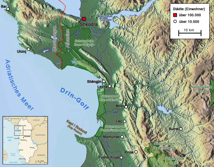
The Drin (; sq, Drin or ; mk, Дрим, Drim ) is a river in Southern and Southeastern Europe with two distributaries one discharging into the Adriatic Sea and the other one into the Buna River. Its catchment area extends across Albania, Kosovo, Serbia, Greece, Montenegro and North Macedonia. The river and its tributaries form the Gulf of Drin, an ocean basin that encompasses the northern Albanian Adriatic Sea Coast. At long, the Drin is the longest river of Albania of which passes across Albania and the remainder through Kosovo and North Macedonia. It starts at the confluence of its two headwaters, namely the Black Drin and White Drin. It originates in the mountainous northern mountain range, flows westwards through the Albanian Alps and Dukagjin Highlands, and eventually drains into the Adriatic Sea, between Shëngjin and Durrës. Numerous lakes and reservoirs are formed by the river or flow into it such as the Fierza Lake and Koman Lake. Located in the Balkan P ... [...More Info...] [...Related Items...] OR: [Wikipedia] [Google] [Baidu] |
Mountains Of Albania
With an average elevation of above sea level, Albania is one of the most mountainous countries in the world. It has a mountainous terrain that covers more than 70% of its total territory. There are many peaks reaching heights of more than . Albania can be divided into four main regions: Northern Range, Central Range, Southern Range and Western Lowlands. The most notable topographical features are the Ceraunian Mountains, Dinaric Alps, Korab Mountains, Pindus Mountains and the Skanderbeg Mountains. The highest peak is Korab standing at elevation above sea level on the border with the Republic of North Macedonia. It is one of only two summits in Europe, which is the highest peak for more than one country. It is also the 18th most prominent mountain peak in Europe. List of mountains in Albania See also * Protected areas of Albania * Geography of Albania * Mountain passes in Albania References {{Portal bar, Ecology Albania Mountains Alb The alb (from th ... [...More Info...] [...Related Items...] OR: [Wikipedia] [Google] [Baidu] |


.jpg)