|
Mahavavy-Kinkony
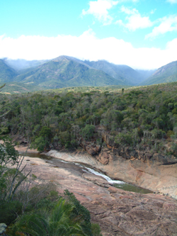
The Mahavavy-Kinkony Reserve is a protected area consisting principally of dry deciduous forest and wetlands in the western part of Madagascar. It owes its name to the Mahavavy Sud River and Lake Kinkony. Nine primate species, 30 fish species, 37 reptile and amphibian species, 133 bird species have been recorded on the wildlife diversity. The Mahavavy-Kinkony Complex IBA, a 300,000-ha landscape including coastal and freshwater wetlands and forests (mangrove and dryland) in Madagascar, including Lake Kinkony Ramsar site and the Mahavavy River Delta, is important to local people for fishing, hunting and agriculture and is home to a large number of threatened wildlife species. Conservation Tsiombikibo Classified Forest (''Forêt Classée de Tsiombikibo'') was established on 19 October 1957 under Order No. 299-AE/PL, covering 21,600 ha. Lake Kinkony was declared a hunting reserve (''réserve de chasse'') on 13 January 1972 by Order No. 0126-SEHAEF/DIR/FOR, with an area of 15,000 ha ... [...More Info...] [...Related Items...] OR: [Wikipedia] [Google] [Baidu] |
Mahavavy Sud River
The Mahavavy Sud, also known as the Mahavavy South, is a river in western Madagascar. It flows from south to north through the regions of Melaky, Betsiboka, and Boeny. It has a length of approximately 1000 km, and drains a basin of 16,475 km2. It is distinct from the Mahavavy Nord several hundred km to the north.Aldegheri, M. (1972). Rivers and Streams on Madagascar. In: Battistini, R., Richard-Vindard, G. (eds) ''Biogeography and Ecology in Madagascar''. Monographiae Biologicae, vol 21. Springer, Dordrecht. https://doi.org/10.1007/978-94-015-7159-3_8 The Mahavavy Sud rises on the Andranofotsibe Massif at about 1000 meters elevation. It flows southwards, joined by the Kiranomena and Manamidona rivers which originate on the Famoizankova massif. The first 125 km of the river's course has a steep gradient, about 7 meters per kilometer. At Kandreho the river enters a east–west depression and is joined by the Mahakambana, which drains the western portion of the depression. Leaving t ... [...More Info...] [...Related Items...] OR: [Wikipedia] [Google] [Baidu] |
National Parks Of Madagascar
This list of national parks of Madagascar includes all officially recognized protected areas as of 2015. The protected areas network of Madagascar is managed by the Madagascar National Parks Association (PNM-ANGAP). The network includes three types of protected areas: Strict Nature Reserves (IUCN category Ia), National Parks (IUCN category II) and Wildlife Reserves (IUCN category IV). At the 2003 IUCN World Parks Congress in Durban, the Malagasy President, Marc Ravalomanana, announced an initiative to more than triple the area under protection from approximately to over (from 3% to 10% of Madagascar's area). This "Durban Vision", as it has been dubbed, involved broadening the definition of protected areas in the country and legislation has been passed to allow the creation of four new categories of protected area: Natural Parks (IUCN category II), Natural Monuments (IUCN category III), Protected Landscapes (IUCN category V), and Natural Resource Reserves (IUCN category VI). As we ... [...More Info...] [...Related Items...] OR: [Wikipedia] [Google] [Baidu] |
Protected Areas Of Madagascar
This list of national parks of Madagascar includes all officially recognized protected areas as of 2015. The protected areas network of Madagascar is managed by the Madagascar National Parks Association (PNM-ANGAP). The network includes three types of protected areas: Strict Nature Reserves ( IUCN category Ia), National Parks (IUCN category II) and Wildlife Reserves (IUCN category IV). At the 2003 IUCN World Parks Congress in Durban, the Malagasy President, Marc Ravalomanana, announced an initiative to more than triple the area under protection from approximately to over (from 3% to 10% of Madagascar's area). This "Durban Vision", as it has been dubbed, involved broadening the definition of protected areas in the country and legislation has been passed to allow the creation of four new categories of protected area: Natural Parks (IUCN category II), Natural Monuments (IUCN category III), Protected Landscapes (IUCN category V), and Natural Resource Reserves (IUCN category VI). As ... [...More Info...] [...Related Items...] OR: [Wikipedia] [Google] [Baidu] |
Boeny
Boeny is a region In geography, regions, otherwise referred to as zones, lands or territories, are areas that are broadly divided by physical characteristics (physical geography), human impact characteristics (human geography), and the interaction of humanity and t ... in northwestern Madagascar. It borders Sofia Region to the northeast, Betsiboka to the south and Melaky to the southwest. The capital of the region is Mahajanga, and the population was 931,171 in 2018. The area of Boeny is . Administrative divisions Boeny Region is divided into six districts, which are sub-divided into 43 communes. * Ambato-Boeni District - 11 communes * Mahajanga, Mahajanga I District - 1 commune * Mahajanga II District - 5 communes * Marovoay District - 12 communes * Mitsinjo District - 7 communes * Soalala District - 3 communes Transport Airports *Amborovy Airport, Mahajanga Airport *Soalala Airport Protected areas *Mahavavy-Kinkony Wetland Complex *Bombetoka Beloboka New Protected Area *Antr ... [...More Info...] [...Related Items...] OR: [Wikipedia] [Google] [Baidu] |
Mahajanga
Mahajanga (French: Majunga) is a city and an administrative district on the northwest coast of Madagascar. The city of Mahajanga (Mahajanga I) is the capital of the Boeny Region. The district (identical to the city) had a population of 220,629 in 2013. Mahajanga is a tourist destination for Malagasy tourists and international travelers, with beaches, a coconut-lined boardwalk ("Le Bord", short for "Bord de la mer" or sea-side), and eight months of hot, virtually rain-free weather. City Mahajanga is a seaport, the second most important one in Madagascar after Toamasina. The marine terminal accommodates containerships and small (150 gross ton) general cargo freighters. Because of limited water depth at the wharf, only small ships can call at the terminal. Deeper-draft ships anchor off the terminal and transfer cargoes to and from barges, which move it to and from the terminal. Severe storms during December 2006 damaged the bulkhead, allowing water to flow in and wash backfi ... [...More Info...] [...Related Items...] OR: [Wikipedia] [Google] [Baidu] |
Mitsinjo
Mitsinjo is a town and commune ( mg, kaominina) in western Madagascar approximately 70 kilometres south of Mahajanga. It belongs to the district of Mitsinjo, which is a part of Boeny Region. The population of the commune was estimated to be approximately 19,000 in 2001 commune census. In addition to primary schooling the town offers secondary education at both junior and senior levels. The majority 70% of the population works in fishing. 15% are farmers, while an additional 10% receives their livelihood from raising livestock. The most important crops are maize and rice; also sweet potato The sweet potato or sweetpotato (''Ipomoea batatas'') is a dicotyledonous plant that belongs to the Convolvulus, bindweed or morning glory family (biology), family, Convolvulaceae. Its large, starchy, sweet-tasting tuberous roots are used as a r ...es is an important agricultural product. Services provide employment for 5% of the population. References and notes Populated places in ... [...More Info...] [...Related Items...] OR: [Wikipedia] [Google] [Baidu] |
Protected Area
Protected areas or conservation areas are locations which receive protection because of their recognized natural, ecological or cultural values. There are several kinds of protected areas, which vary by level of protection depending on the enabling laws of each country or the regulations of the international organizations involved. Generally speaking though, protected areas are understood to be those in which human presence or at least the exploitation of natural resources (e.g. firewood, non-timber forest products, water, ...) is limited. The term "protected area" also includes marine protected areas, the boundaries of which will include some area of ocean, and transboundary protected areas that overlap multiple countries which remove the borders inside the area for conservation and economic purposes. There are over 161,000 protected areas in the world (as of October 2010) with more added daily, representing between 10 and 15 percent of the world's land surface area. As of 20 ... [...More Info...] [...Related Items...] OR: [Wikipedia] [Google] [Baidu] |
Lake Kinkony
Lake Kinkony is a large lake in the northwestern part of Madagascar, in the lower Mahavavy Sud River watershed in Boeny region (former Mahajanga Province Mahajanga was a former province of Madagascar that had an area of 150,023 km². It had a population of 1,896,000 (2004). Its capital was Mahajanga, the second largest city in Madagascar. Except for Fianarantsoa, Mahajanga Province bordere ...). It is located at around and has an area of about 100 km². The lake is an important wetland site for birds. References Kinkony Mahajanga Province Boeny Ramsar sites in Madagascar Important Bird Areas of Madagascar {{Madagascar-geo-stub ... [...More Info...] [...Related Items...] OR: [Wikipedia] [Google] [Baidu] |
Geography Of Madagascar
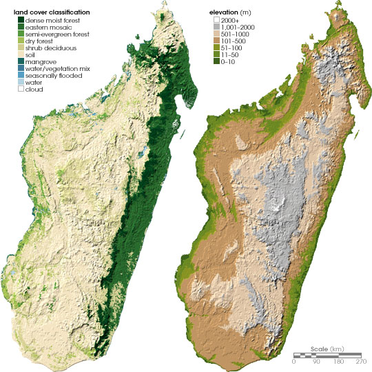
Madagascar is a large island in the Indian Ocean off the eastern coast of southern Africa, east of Mozambique. It has a total area of with of land and of water. Madagascar is the fourth largest island and the 2nd largest island country in the world. The highest point is Maromokotro, in the Tsaratanana Massif region in the north of the island, at . The capital Antananarivo is in the Central Highlands near the centre of the island. It has the 25th largest Exclusive Economic Zone of . Madagascar is 400 kilometres (250 miles) east of mainland Africa. Geographical regions Madagascar can be divided into five general geographical regions: the east coast, the Tsaratanana Massif, the Central Highlands, the west coast, and the southwest. The highest elevations parallel the east coast. The total size is , which makes it the world's second largest island country. East coast The east coast consists of a narrow band of lowlands about fifty kilometers wide, formed from the sedimentatio ... [...More Info...] [...Related Items...] OR: [Wikipedia] [Google] [Baidu] |
Mahajanga Province
Mahajanga was a former province of Madagascar that had an area of 150,023 km². It had a population of 1,896,000 (2004). Its capital was Mahajanga, the second largest city in Madagascar. Except for Fianarantsoa, Mahajanga Province bordered all of the country's other provinces–Antsiranana in the north, Toamasina in the east, Antananarivo in the southeast and Toliara in the southwest. Sea cucumbers were an important commercial product produced in the province. In 1999, cholera epidemic broke out in the province. It infected 380 people and claimed 26 lives. The epidemic spread towards the southern Antananarivo and Toliara provinces. The province was hit by Cyclone Kamisy in June 1984. A large percentage of the province's population lived below the poverty line. A large area of the province was covered by rain forests. It had a rich variety of flora and fauna. Several lemur species were endemic to the province. Assassin spiders were discovered in the province's Bay o ... [...More Info...] [...Related Items...] OR: [Wikipedia] [Google] [Baidu] |
Protected Areas Established In 2007
Protection is any measure taken to guard a thing against damage caused by outside forces. Protection can be provided to physical objects, including organisms, to systems, and to intangible things like civil and political rights. Although the mechanisms for providing protection vary widely, the basic meaning of the term remains the same. This is illustrated by an explanation found in a manual on electrical wiring: Some kind of protection is a characteristic of all life, as living things have evolved at least some protective mechanisms to counter damaging environmental phenomena, such as ultraviolet light. Biological membranes such as bark on trees and skin on animals offer protection from various threats, with skin playing a key role in protecting organisms against pathogens and excessive water loss. Additional structures like scales and hair offer further protection from the elements and from predators, with some animals having features such as spines or camouflage servin ... [...More Info...] [...Related Items...] OR: [Wikipedia] [Google] [Baidu] |


