|
Madera County Connection
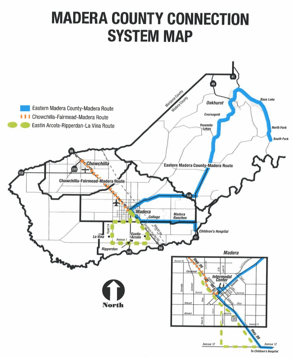
Madera County Connection (MCC) is the primary bus agency providing intercity services within Madera County, California. It is operated by the County Department of Public Works and offers four fixed routes connecting the cities of Chowchilla and Madera with Valley Children's Hospital and smaller unincorporated communities in the county. All four routes meet at the same intermodal terminal in downtown Madera, where riders may transfer to Madera Metro intracity buses or Greyhound Lines intercity buses. Passengers may take Madera Metro to the train station and transfer to the Amtrak ''San Joaquins'' intercity service connecting the San Francisco Bay Area and Los Angeles. Madera County also is responsible for operating dial-a-ride point-to-point services in the unincorporated areas surrounding Madera and Chowchilla (MCC Madera and Chowchilla Dial-A-Ride, respectively), a demand-responsive bus for seniors in the rural eastern part of the county (Eastern Madera County Senior Bus), and a ... [...More Info...] [...Related Items...] OR: [Wikipedia] [Google] [Baidu] |
Madera County, California
Madera County (), officially the County of Madera, is a county at the geographic center of the U.S. state of California. As of the 2020 census, the population was 156,255. The county seat is Madera. Madera County comprises the Madera, CA Metropolitan Statistical Area, which is included in the Fresno-Madera, CA Combined Statistical Area. It is located in the eastern San Joaquin Valley and the central Sierra Nevada. The southeasternmost part of Yosemite National Park is located in the county's northeast. History and etymology Madera County was formed in 1893 from Fresno County during a special election held in Fresno on May 16, 1893. Citizens residing in the area that was to become Madera County voted 1,179 to 358 for separation from Fresno County and the establishment of Madera County. Madera is the Spanish term for wood. The county derives its name from the town of Madera, named when the California Lumber Company built a log flume to carry lumber to the Central Pacific R ... [...More Info...] [...Related Items...] OR: [Wikipedia] [Google] [Baidu] |
San Francisco Bay Area
The San Francisco Bay Area, often referred to as simply the Bay Area, is a populous region surrounding the San Francisco, San Pablo, and Suisun Bay estuaries in Northern California. The Bay Area is defined by the Association of Bay Area Governments to include the nine counties that border the aforementioned estuaries: Alameda, Contra Costa, Marin, Napa, San Mateo, Santa Clara, Solano, Sonoma, and San Francisco. Other definitions may be either smaller or larger, and may include neighboring counties that do not border the bay such as Santa Cruz and San Benito (more often included in the Central Coast regions); or San Joaquin, Merced, and Stanislaus (more often included in the Central Valley). The core cities of the Bay Area are San Francisco, San Jose, and Oakland. Home to approximately 7.76 million people, Northern California's nine-county Bay Area contains many cities, towns, airports, and associated regional, state, and national parks, connected by a comp ... [...More Info...] [...Related Items...] OR: [Wikipedia] [Google] [Baidu] |
California State Route 41
State Route 41 (SR 41) is a state highway in California, connecting the Central Coast with the San Joaquin Valley and the Sierra Nevada. Its western terminus is at the Cabrillo Highway ( SR 1) in Morro Bay, and its eastern terminus is at SR 140 in Yosemite National Park. It has been constructed as an expressway from near SR 198 in Lemoore north to the south part of Fresno, where the Yosemite Freeway begins, passing along the east side of downtown and extending north into Madera County. Route description The majority of Route 41 runs as either two-lane rural highway or four-lane divided highway. The only part of SR 41 that turns into a freeway itself is in Fresno County and parts of Madera. The southern end of the highway intersects SR 1 in Morro Bay. Between Morro Bay and Fresno, the highway intersects U.S. Route 101 in Atascadero, proceeds through the Coast Range and intersects SR 46. Actor James Dean died in an accident in 1955 at the intersection of SR 46 in Cholame. ... [...More Info...] [...Related Items...] OR: [Wikipedia] [Google] [Baidu] |
California State Route 145
State Route 145 is a state highway in the U.S. state of California, running through the heart of the San Joaquin Valley from Interstate 5 near Coalinga north to Route 41 north of Fresno. Route description SR 145 travels through the center of the San Joaquin Valley, remaining a rural two-lane road in its entirety. The southern terminus of SR 145 is at I-5 near Coalinga. SR 145 heads northeast as Fresno-Coalinga Road, turning north at the junction with SR 269 in Five Points, where it assumes the designation as Lassen Avenue. After passing through the town of Helm, SR 145 heads northeast as McMullin Grade, before turning north again as South Madera Avenue. SR 145 intersects with SR 180 in the city of Kerman, where it continues north to cross into Madera County. After passing through Ripperdan, SR 145 intersects SR 99 in Madera. From Madera, the route turns east, and ends at SR 41. Various crops such as cotton, table grapes, tomatoes and melons are grown along the route in one ... [...More Info...] [...Related Items...] OR: [Wikipedia] [Google] [Baidu] |
South Fork, Madera County, California
South Fork (Mono: qohnihihna )Sydney M. Lamb. 1957''Mono Grammar'' University of California. Berkeley PhD dissertation. .pdf is an unincorporated community in Madera County, associated with the neighboring town of North Fork California California is a U.S. state, state in the Western United States, located along the West Coast of the United States, Pacific Coast. With nearly 39.2million residents across a total area of approximately , it is the List of states and territori .... It is located south-southeast of Shuteye Peak, at an elevation of 2651 feet (808 m). South Fork lacks a post-office or any distinguishing features aside from a motel resembling one featured in a celebrated Alfred Hitchcock film. References Unincorporated communities in California Unincorporated communities in Madera County, California Mono people {{MaderaCountyCA-geo-stub ... [...More Info...] [...Related Items...] OR: [Wikipedia] [Google] [Baidu] |
North Fork, California
North Fork (formerly Brown's and Northfork; Mono wa?ahhpY', "cedar grove") is a census-designated place (CDP) in Madera County, California, United States. As of the 2020 United States census it had a population of 3,250. It is part of the Madera Metropolitan Statistical Area. The Northfork Rancheria of Mono Indians of California maintains their tribal headquarters in North Fork. Geography North Fork is located in the foothills of the Sierra Nevada at an elevation of . It is north-northeast of Fresno, northeast of Madera, and by road southeast of Oakhurst. According to the U.S. Census Bureau, the North Fork CDP has a total area of , of which , or 0.14%, are water. The community is drained by Willow Creek and by its North Fork and South Fork. Willow Creek is a south-flowing tributary of the San Joaquin River. The geographic center or midpoint of the state of California is located between North Fork and Italian Bar. The point is about driving distance from the United S ... [...More Info...] [...Related Items...] OR: [Wikipedia] [Google] [Baidu] |
Bass Lake, California
Bass Lake is a census-designated place in Madera County, California, United States. It is located southeast of Yosemite Forks, at an elevation of . The population was 575 at the 2020 census. Bass Lake is situated in the Sierra National Forest approximately from the south entrance of Yosemite National Park. Established in 1895 as "Bass Lake Village", the community grew up around the newly created Bass Lake reservoir that supplied the first hydroelectric generating project in Central California. Much of the community and the reservoir is devoted to the tourism industry. The original post office at Bass Lake opened in 1912. The ZIP Codes for Bass Lake are 93604 and 93669, and it is in the 559 area code. Geography According to the United States Census Bureau The United States Census Bureau (USCB), officially the Bureau of the Census, is a principal agency of the U.S. Federal Statistical System, responsible for producing data about the American people and economy. The C ... [...More Info...] [...Related Items...] OR: [Wikipedia] [Google] [Baidu] |
Yosemite Lakes, California
Yosemite Lakes Park (''Yosemite'', Miwok for "killer") is an unincorporated community in Madera County, California. It lies at an elevation of . As a census-designated place (CDP) it is known as Yosemite Lakes. It is part of the Madera Metropolitan Statistical Area. The population was 5,022 at the 2020 census. Geography Yosemite Lakes is located in the foothills of the Sierra Nevada at . Its northwest border follows the Fresno River, and to the south and east it is bound by Coarsegold creek. The highest point in the community is Lilley Mountain at . The community is bordered to the northeast by Coarsegold, and it is north of Fresno. According to the United States Census Bureau, the CDP has a total area of , of which , or 0.46%, are water. Demographics 2010 The 2010 United States Census reported that Yosemite Lakes had a population of 4,952. The population density was . The racial makeup of Yosemite Lakes was 4,408 (89.0%) White, 38 (0.8%) African American, 91 (1.8%) Native ... [...More Info...] [...Related Items...] OR: [Wikipedia] [Google] [Baidu] |
California State Route 99
State Route 99 (SR 99), commonly known as Highway 99 or, simply, as 99 (without any further designation), is a north–south state highway in the U.S. state of California, stretching almost the entire length of the Central Valley. From its southern end at Interstate 5 (I-5) near Wheeler Ridge to its northern end at SR 36 near Red Bluff, SR 99 goes through the densely populated eastern parts of the valley. Cities served include Bakersfield, Delano, Tulare, Visalia, Kingsburg, Selma, Fresno, Madera, Merced, Turlock, Modesto, Manteca, Stockton, Sacramento, Yuba City, and Chico. The highway is a remnant of the former Mexico to Canada U.S. Route 99 (US 99), which was decommissioned in 1972 after being functionally replaced by I-5 for long-distance traffic south of Sacramento. The entire segment from Wheeler Ridge to Sacramento has been upgraded as of January 2016 to a freeway at least four lanes wide, and the California Department of Transpor ... [...More Info...] [...Related Items...] OR: [Wikipedia] [Google] [Baidu] |
Madera Community College
Madera Community College, established in 2020, is a community college located in Madera, California. It originally opened in 1996 as Madera Community College Center, a campus of the State Center Community College District State Center Community College District (SCCCD) is a California Community Colleges System district in Central California, including Fresno City College in Fresno, Reedley College in Reedley, and Clovis Community College in north Fresno, and Made .... References External linksMadera Community College California Community Colleges 2020 establishments in California Education in Madera County, California {{California-university-stub ... [...More Info...] [...Related Items...] OR: [Wikipedia] [Google] [Baidu] |
Children's Hospital Central California
Valley Children's Hospital (VCH), formerly Children's Hospital Central California is a stand-alone, pediatric acute care children's teaching hospital located in Madera County, California. The hospital has 358 pediatric beds and is affiliated the Stanford University School of Medicine. The hospital is a member of Valley Children's Healthcare and is one of only two children's hospitals in the network, servicing approximately 1.3 million children and adolescents in their coverage area. The hospital provides comprehensive pediatric specialties and subspecialties to infants, children, teens, and young adults aged 0–21 throughout Madera County, Fresno, and California. Valley Children's also sometimes treats adults that require pediatric care. Valley Children's also features the largest ACS verified Level 2 Pediatric Trauma Center in the region, the only Level IV NICU in the Central Valley, and the only provider of pediatric extracorporeal life support (ECLS) for their service area ... [...More Info...] [...Related Items...] OR: [Wikipedia] [Google] [Baidu] |
Madera County Connection System Map
Madera is the Spanish word for lumber. It may also refer to: Places Americas * Madera County, California, in the United States ** Madera, California, the county seat of Madera County ** Madera Peak, a mountain in Madera County ** Madera Ranchos, California, an unincorporated community in Madera County ** Madera AVA, a wine region partially located in Madera County * Madera, Chihuahua, in Mexico * La Madera, Rio Arriba County, New Mexico * La Madera, Sandoval County, New Mexico * Madera, Pennsylvania Europe *Madera, Kuyavian-Pomeranian Voivodeship (north-central Poland) *Madera, Łódź Voivodeship (central Poland) *Madera, Pomeranian Voivodeship (north Poland) * Paterna del Madera, Albacete, Spain Train stations *Madera station (Amtrak), a train station in Madera, California **Storey station, a closed train station referred by Amtrak as "Madera" *Madera station (California High-Speed Rail), a proposed train station *Madera station (Medellín), a metro station in Colombia Peo ... [...More Info...] [...Related Items...] OR: [Wikipedia] [Google] [Baidu] |


