|
Madawaska—Restigouche
Madawaska—Restigouche is a federal electoral district in New Brunswick, Canada, that has been represented in the House of Commons of Canada since 1997. Its population in 2001 was 65,877. Political geography The district includes all of the County of Madawaska (except Saint-André) and all of the County of Restigouche except the extreme eastern part. The neighbouring ridings are Miramichi, Tobique—Mactaquac, Rimouski-Neigette—Témiscouata—Les Basques, Haute-Gaspésie—La Mitis—Matane—Matapédia, and Gaspésie—Îles-de-la-Madeleine. In 2008, Liberal support was focused in the eastern and central parts of the riding, particularly in Edmundston, Campbellton, and Dalhousie. Support for the Conservatives was centered in the western part of the riding, in a strip of land bordering both Maine and Quebec. There was also a pocket of Tory support outside Saint-Leonard. The NDP won six polls in the riding, all in the Dalhousie area, a community they won.Pundit ... [...More Info...] [...Related Items...] OR: [Wikipedia] [Google] [Baidu] |
Restigouche—Chaleur
Restigouche (also known as Restigouche—Chaleur) was a federal electoral district (Canada), electoral district in New Brunswick, Canada, that was represented in the House of Commons of Canada from 1867 to 1917 and from 1968 to 1997. It was created by the British North America Act of 1867. It consisted of the County of Restigouche. It was abolished in 1914 when it was merged into Restigouche—Madawaska Riding (division), riding. It was re-created in 1966 from Restigouche—Madawaska, consisting of the county of Restigouche and the parish of Beresford in the county of Gloucester. It was renamed "Restigouche—Chaleur" in 1989. The riding was abolished in 1996 when it was merged into Madawaska—Restigouche. Members of Parliament This riding elected the following Member of Parliament, Members of Parliament: Election results Restigouche—Chaleur, 1993–1997 Restigouche, 1968–1993 , - , Liberal Party of Canada, Liberal , Maurice Ha ... [...More Info...] [...Related Items...] OR: [Wikipedia] [Google] [Baidu] |
Madawaska—Victoria
Madawaska—Victoria was a federal electoral district in New Brunswick, Canada, that was represented in the House of Commons of Canada from 1968 to 1997. The riding consisted of Madawaska and Victoria Counties, which until 1966 had been part of Restigouche—Madawaska and Victoria—Carleton respectively. The district's boundaries did not change during its 30 years. With the 1996 redistribution, most of Madawaska County was placed in the revived Madawaska—Restigouche, while Victoria County became part of Tobique—Mactaquac riding. Bernard Valcourt, the only non-Liberal ever elected from this riding, served several positions in Brian Mulroney's cabinet between 1988 and 1993. Members of Parliament This riding elected the following Members of Parliament: Election results , - , Liberal , Pierrette Ringuette , align="right", 16,058 , align="right", 48.8 , align="right", +5.0 , - , style="width: 150px" , Progressive Conservative , Bernard Valcourt , ali ... [...More Info...] [...Related Items...] OR: [Wikipedia] [Google] [Baidu] |
Canadian Federal Electoral Redistribution, 2012
The federal electoral redistribution of 2012 was a redistribution of electoral districts ("ridings") in Canada following the results of the 2011 Canadian census. As a result of amendments to the Constitution Act, 1867, the number of seats in the House of Commons of Canada increased from 308 to 338. The previous electoral redistribution was in 2003. Background and previous attempts at reform Prior to 2012, the redistribution rules for increasing the number of seats in the House of Commons of Canada was governed by section 51 of the ''Constitution Act, 1867'', as last amended in 1985. As early as 2007, attempts were made to reform the calculation of how that number was determined, as the 1985 formula did not fully take into account the rapid population growth being experienced in the provinces of Alberta, British Columbia and Ontario. The revised formula, as originally presented, was estimated to have the following impact: Three successive bills were presented by the Government ... [...More Info...] [...Related Items...] OR: [Wikipedia] [Google] [Baidu] |
Edmundston
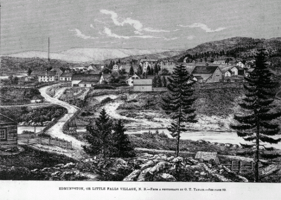
Edmundston is a city in Madawaska County, New Brunswick, Canada. On 1 January 2023, Edmundston will expanded, annexing the village of Rivière-Verte and parts of the local service districts of the parish of Saint-Jacques and the parish of Saint-Joseph. History During the early colonial period, the area was a camping and meeting place of the Maliseet (Wolastoqiyik) Nation during seasonal migrations. From the mid to late eighteenth century, one of the largest Maliseet villages had been established at Madawaska and had become a refuge site for other Wabanaki peoples. The Maliseet village was originally located near the falls at the confluence of the Madawaska and Saint John Rivers. Currently, the City of Edmundston surrounds a federal Indian Reserve (St. Basile 10/Madawaska Maliseet First Nation). Originally named ''Petit-Sault'' (Little Falls) in reference to the waterfalls located where the Madawaska River merges into the Saint John River, the settlement was renamed ''Edmun ... [...More Info...] [...Related Items...] OR: [Wikipedia] [Google] [Baidu] |
Tobique—Mactaquac
Tobique—Mactaquac is a federal electoral district in New Brunswick, Canada, that has been represented in the House of Commons of Canada since 1997. Political geography The district includes the counties of Carleton and Victoria as well as the Parish and Village of Saint-André and the eastern part of the County of York (excluding the City of Fredericton and vicinity). The neighbouring ridings are Madawaska—Restigouche, Miramichi, Fredericton, and New Brunswick Southwest. Across the border to Maine, it neighbours the Maine District 2 of the United States House of Representatives. The electoral district was created in 1996 from portions of the old ridings of Carleton—Charlotte, Fredericton—York—Sunbury, and Madawaska—Victoria. Its creation was very controversial, as it included areas with both large anglophone and francophone populations, while neighbouring communities were placed in other ridings. This seemingly went against the "communities of interest" ... [...More Info...] [...Related Items...] OR: [Wikipedia] [Google] [Baidu] |
Rimouski-Neigette—Témiscouata—Les Basques
Rimouski-Neigette—Témiscouata—Les Basques (formerly known as Rimouski—Témiscouata) is a federal electoral district in Quebec, Canada, that has been represented in the House of Commons of Canada since 2004. Geography This eastern Quebec riding includes the regional county municipalities of Rimouski-Neigette, Les Basques and Témiscouata, in the Quebec region of Bas-Saint-Laurent. The neighbouring ridings are Montmagny—L'Islet—Kamouraska—Rivière-du-Loup, Montmorency—Charlevoix—Haute-Côte-Nord, Haute-Gaspésie—La Mitis—Matane—Matapédia, and Madawaska—Restigouche. History Rimouski-Neigette—Témiscouata—Les Basques was created in 2003 as "Rimouski—Témiscouata" from parts of Kamouraska—Rivière-du-Loup—Témiscouata—Les Basques and Rimouski-Neigette-et-La Mitis ridings. The district was given its present name in 2004. Rimouski-Neigette—Témiscouata—Les Basques was a safe seat for Bloc Québécois until 2011, when New Democrat Guy C ... [...More Info...] [...Related Items...] OR: [Wikipedia] [Google] [Baidu] |
Kedgwick, New Brunswick
Kedgwick is a Canadian incorporated rural community in northern New Brunswick, Canada. On 1 January 2023, Kedgwick annexed a large area including the local service districts of St. Jean Baptiste – Menneval and White's Brook, with parts of two others. A variation of the original Micmac Madawamkedjwik, the name was "shortened by the river men to Tom Kedgwick or Kedgwick" (Ganong). Of uncertain meaning. Appears as Grande Fourche, " Big Fork", on some maps; however, the older variant prevailed. Forestry is the major industry in the area. History Originally a local improvement district, then an incorporated village, Kedgwick became a rural community in 2012 when it amalgamated with the surrounding local service district of the parish of Grimmer. Geography Located in the Appalachian Mountains in the western part of the county, Kedgwick is approximately 75 kilometres southwest of Campbellton and 15 kilometres east of the Restigouche River along Route 17. Being surrounded by wo ... [...More Info...] [...Related Items...] OR: [Wikipedia] [Google] [Baidu] |
Saint-Quentin, New Brunswick
Saint-Quentin is a town in northern New Brunswick, Canada. Saint-Quentin is in the Restigouche region of the Appalachian Mountains, 50 kilometres west of Mount Carleton, the province's highest elevation. The majority of individuals in the area speak French. On 1 January 2023, Saint-Quentin annexed the local service district (LSD) of St. Martin de Restigouche and part of the LSD of the parish of Saint-Quentin Revised census figures have not been released. History In 1897, the Restigouche and Western Railway Company embarked on a project to build a railway linking Campbellton and St-Léonard, two towns in northwestern New Brunswick. The progress of its construction sent workers deep into the forest. In 1909, Simon Gallant, an Acadian working as a blacksmith, decided to settle his family by a stream near Five Fingers where he found a stray cow. At the same time, authorities began to worry about the emigration of Québec families to the United States and to Western Canada ... [...More Info...] [...Related Items...] OR: [Wikipedia] [Google] [Baidu] |
Dalhousie, New Brunswick
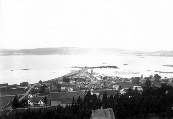
Dalhousie ( ) is a formerly incorporated town, located in Restigouche County, New Brunswick. New Brunswick's northernmost point of land is situated in Dalhousie, where the Restigouche River meets Chaleur Bay. On 1 January 2023, Dalhousie merged with the village of Charlo and several local service districts (LSDs) to form the new town of Heron Bay – French name ''Baie-des-Hérons''. Dalhousie remains in use by the province's 911 system. History Dalhousie is the shire town of Restigouche County and dates European settlement to 1800. The Town of Dalhousie has been through some very distinct periods between its founding in 1825 and today. Prior to 1825, few showed much interest in the northern part of the province, but in that year the Great Miramichi Fire raged through central New Brunswick and into Maine, destroying the forests that were the mainstay of the province's economy. Lumbermen looked north to the great pine stands of the Nipisiguit and the Restigouche. Dalhous ... [...More Info...] [...Related Items...] OR: [Wikipedia] [Google] [Baidu] |
Campbellton, New Brunswick
Campbellton is a city in Restigouche County, New Brunswick, Canada. Situated on the south bank of the Restigouche River opposite Pointe-à-la-Croix, Quebec, Campbellton was officially incorporated in 1889 and achieved city status in 1958. Forestry and tourism are major industries in the regional economy, while a pulp mill in the Campbellton community of Atholville is the largest single employer in the area. As part of the tourism "industry", wealthy sportfishermen seeking Atlantic salmon flock to the scenic Restigouche Valley every summer. The region sees extensive annual snowfall. Alpine and Nordic ski facilities at Sugarloaf Provincial Park provide winter recreation opportunities for both visitors and local residents. Campbellton is also a local retail and service centre. On 1 January 2023, Campbellton amalgamated with the villages of Atholville and Tide Head, the local service district (LSD) of Glencoe and parts of four other LSDs. The names of the annexed communities ... [...More Info...] [...Related Items...] OR: [Wikipedia] [Google] [Baidu] |
Haute-Gaspésie—La Mitis—Matane—Matapédia
Haute-Gaspésie—La Mitis—Matane—Matapédia (formerly known as Matapédia—Matane) was a federal electoral district in Quebec, Canada, that was represented in the House of Commons of Canada from 1979 until 2013. It has the lowest percentage of visible minorities among all Canadian electoral districts (0.3%). Geography The district consists of the Regional County Municipalities of La Haute-Gaspésie, La Matapédia, Matane and La Mitis. The neighbouring ridings are Rimouski-Neigette—Témiscouata—Les Basques, Montmorency—Charlevoix—Haute-Côte-Nord, Manicouagan, Gaspésie—Îles-de-la-Madeleine, and Madawaska—Restigouche. History The riding was created in 1933 as "Matapédia—Matane" from parts of Matane riding. It was abolished in 1966 when it was redistributed into Matane and Rimouski ridings. It was created in 1976 as "Matapédia—Matane" from parts of Matane and Rimouski ridings. The name of the riding was changed in 2004 to "Haute-Gaspésie—La M ... [...More Info...] [...Related Items...] OR: [Wikipedia] [Google] [Baidu] |


