|
Ma'ale HaShalom
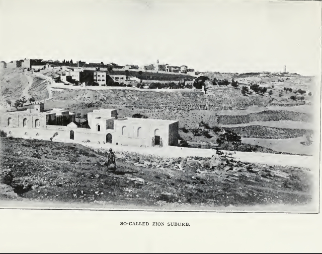
Ma'ale ha-Shalom ( he, ū×ūóū£ūö ūöū®ū£ūĢūØ, translates to ''Ascent of Peace''), also known as the Pope's Road ( he, ūøūæūÖū® ūöūÉųĘūżų┤ų╝ūÖūżų░ūÖūĢų╣ū©, ), is a street in East Jerusalem. Ma'ale HaShalom connects Route 60 to Ma'alot Ir David where it becomes Derech ha-Ofel. It goes along the southern border of the Old City, and has the Dung Gate where the entrance to the Jewish Quarter is found. It also goes alongside the Protestant Mount Zion Cemetery and Catholic cemeteries. Though outside the walls of today's old city, the road is considered to be inside of historic sanctified Jerusalem. Before 1964, the way to Mount Zion was a narrow dirt track. That year, Pope Paul VI planned to visit Jerusalem and in his honour, the Jordanians allowed for the widening and laying of a proper road to enable the Pope to be driven to the Coenaculum. Prior to the Six-Day War, this street was known as Ain el-loza. [...More Info...] [...Related Items...] OR: [Wikipedia] [Google] [Baidu] |
East Jerusalem
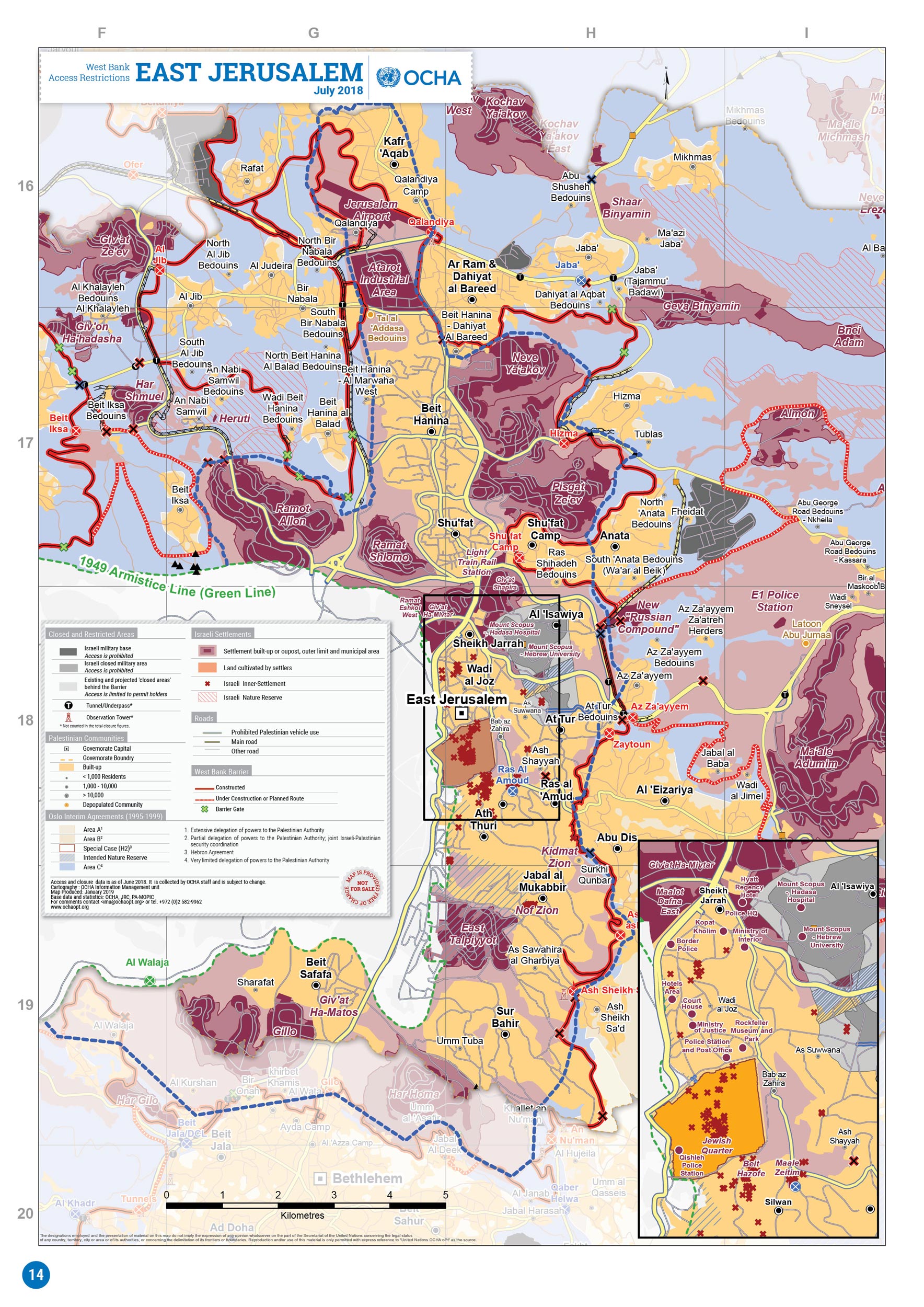
East Jerusalem (, ; , ) is the sector of Jerusalem that was held by Jordan during the 1948 ArabŌĆōIsraeli War, as opposed to the western sector of the city, West Jerusalem, which was held by Israel. Jerusalem was envisaged as a separate, international city under the 1947 United Nations partition plan. It was, however, divided by the 1948 war that followed Israel's declaration of independence. As a result of the 1949 Armistice Agreements, the city's western half came under Israeli control, while its eastern half, containing the famed Old City, fell under Jordanian control. Israel occupied East Jerusalem during the 1967 Six-Day War; since then, the entire city has been under Israeli control. The 1980 Jerusalem Law declared unified Jerusalem the capital of Israel, formalizing the effective annexation of East Jerusalem. Palestinians and many in the international community consider East Jerusalem to be the future capital of the State of Palestine. This includes (out of ... [...More Info...] [...Related Items...] OR: [Wikipedia] [Google] [Baidu] |
Highway 60 (IsraelŌĆōPalestine)
Highway 60 or ( he, ūøūæūÖū® 60, "Kvish Shishim"; ar, ž¦┘äžĘž▒┘Ŗ┘é ž¦┘äž│ž▒┘Ŗž╣ 60) is a south-north intercity road in Israel and the West Bank that stretches from Beersheba to Nazareth. Route and specifics The Highway is in large parts following the same general route as the so-called biblical "Way of the Patriarchs" ( he, ūōū©ūÜ ūöūÉūæūĢū¬, (Derech HaAvot)), since it also follows the central watershed of the hill country, which figures prominently in the travels of the Biblical patriarchs. From its junction with Highway 40 in Beersheba to the city's outskirts, Route 60 is a dual carriageway with at-grade intersections. While it continues on to serve as the main north-south artery between Israeli settlements and Palestinian communities such as the cities of Hebron and Bethlehem in the southern West Bank, it is a two-lane, shoulderless road until past Hebron at Gush Etzion Junction, where it regains its lane-separation until short of Bethlehem, that section having recently bee ... [...More Info...] [...Related Items...] OR: [Wikipedia] [Google] [Baidu] |
Ma'alot Ir David
Ma'alot-Tarshiha ( he, ū×ųĘūóų▓ū£ūĢų╣ū¬-ū¬ųĘų╝ū©ų░ū®ų┤ūüūÖūŚųĖūÉ; ar, ┘ģž╣ž¦┘ä┘łž¬ ž¬ž▒ž┤┘ŖžŁž¦, ''Ma╩╗─ül┼½t Tar┼Ī─½ßĖź─ü'') is a city in the North District in Israel, some east of Nahariya, about above sea level. The city was established in 1963 through a municipal merger of the Arab town of Tarshiha and the Jewish town of Ma'alot, creating a unique type of Israeli mixed city. In , the city had a population of . History Tarshiha Excavations of a 4th-century burial cave in the village unearthed a cross and a piece of glass engraved with a menorah. Crusader sources from the 12th and 13th century refer to Tarshiha as ''Terschia,'' ''Torsia'', and ''Tersigha.''Petersen, 2001, p293/ref> The King had initiated the settlement of Crusader (''Latin'', ''Frankish'') people in nearby Mi'ilya ("Castellum Regis"), and from there settlement spread out to Tarshiha. In 1160, ''Torsia'' and several surrounding villages were transferred to a Crusader named ''Iohanni de Caypha'' (Johannes of ... [...More Info...] [...Related Items...] OR: [Wikipedia] [Google] [Baidu] |
Old City (Jerusalem)
The Old City of Jerusalem ( he, ūöųĖūóų┤ūÖū© ūöųĖūóųĘū¬ų┤ų╝ūÖū¦ųĖūö, translit=ha-ir ha-atiqah; ar, ž¦┘äž©┘äž»ž® ž¦┘ä┘éž»┘Ŗ┘ģž®, translit=al-Balda al-Qadimah; ) is a walled area in East Jerusalem. The Old City is traditionally divided into four uneven quarters, namely: the Muslim Quarter, the Christian Quarter, the Armenian Quarter, and the Jewish Quarter. A fifth area, the Temple Mount, known to Muslims as the ''Haram al-Sharif'', is home to the Dome of the Rock, Al-Aqsa Mosque and was once the site of two Jewish Temples. The current designations were introduced in the 19th century. The Old City's current walls and city gates were built by the Ottoman Empire from 1535 to 1542 under Suleiman the Magnificent. The Old City is home to several sites of key importance and holiness to the three major Abrahamic religions: the Temple Mount and Western Wall for Judaism, the Church of the Holy Sepulchre for Christianity, and the Dome of the Rock and al-Aqsa Mosque for Islam. The ... [...More Info...] [...Related Items...] OR: [Wikipedia] [Google] [Baidu] |
Dung Gate
The Dung Gate ( he, ū®ūóū© ūöūÉū®ūżūĢū¬ ''Sha'ar Ha'ashpot'') or Silwan Gate, also known as the Mughrabi Gate ( ar, ž©ž¦ž© ž¦┘ä┘ģž║ž¦ž▒ž©ž® ''Bab al-Maghariba''), is one of the Gates of the Old City of Jerusalem. It was built as a small postern gate in the 16th century by the Ottomans, first widened for vehicular traffic in 1952 by the Jordanians, and again in 1985 by the Israeli authorities. The gate is situated near the southeast corner of the Old City, southwest of the Temple Mount. Directly behind the gate lies the entrance to the Western Wall Plaza. The Dung Gate is a main passage for vehicles coming out of the Old City and for buses headed to the Western Wall. Names Built by the Ottomans in the 16th century, this small gate was then called Mughrabi Gate. In the 19th century, it started being called Dung Gate by Jews. It is also known as the Silwan Gate. The original ''Dung Gate'' ( he, ū®ūóū© ūöūÉū®ūżūĢū¬ ''Sha'ar Ha'ashpot'') was, in the Hebrew Bible (, the name of a g ... [...More Info...] [...Related Items...] OR: [Wikipedia] [Google] [Baidu] |
Jewish Quarter (Jerusalem)
The Jewish Quarter ( he, ūöū©ūĢūæūó ūöūÖūöūĢūōūÖ, ''HaRova HaYehudi''; ar, žŁž¦ž▒ž® ž¦┘ä┘Ŗ┘ć┘łž», ''Harat al-Yehud'') is one of the four traditional quarters of the Old City of Jerusalem (part of Israeli-occupied East Jerusalem). The 116,000 square meter area lies in the southwestern sector of the walled city, and stretches from the Zion Gate in the south, along the Armenian Quarter on the west, up to the Street of the Chain in the north and extends to the Western Wall and the Temple Mount in the east. In the early 20th century the Jewish population of the quarter reached 19,000. Rashid Khalidi calculated that the quarter "originally" covered "four or five acres" (c. 16,200-20,250 m2), of which prior to 1948 the Jewish-owned property amounted to less than 20%. The quarter is inhabited by around 2,000 residents and is home to numerous ''yeshivas'' and synagogues, most notably the Hurva Synagogue, destroyed numerous times and rededicated in 2010. The quarter is also the site of ... [...More Info...] [...Related Items...] OR: [Wikipedia] [Google] [Baidu] |
Mount Zion Cemetery, Jerusalem (Protestant)
The Protestant Mount Zion Cemetery (a.k.a., Jerusalem Mount Zion Protestant Cemetery, german: link=no, Zionsfriedhof; he, ūæūÖū¬ ūöū¦ūæū©ūĢū¬ ūöūżū©ūĢūśūĪūśūĀūśūÖ ūæūöū© ū”ūÖūĢū¤) on Mount Zion in Jerusalem, is a cemetery owned by the Anglican ''Church Missionary Trust Association Ltd.'', London, represented by the Episcopal Church in Jerusalem and The Middle East. In 1848 Samuel Gobat, Bishop of Jerusalem, opened the cemetery and dedicated it as ecumenical graveyard for congregants of Anglican, Lutheran, Reformed (Calvinist) and old Catholic faith. Since its original beneficiary, the Bishopric of Jerusalem was maintained as a joint venture of the Anglican Church of England and the Evangelical Church in Prussia, a united Protestant Landeskirche of Lutheran and Reformed congregations, until 1886, the Jerusalem Lutheran congregation preserved a right to bury congregants there also after the Jerusalem Bishopric had become a solely Anglican diocese. Location The cemetery ... [...More Info...] [...Related Items...] OR: [Wikipedia] [Google] [Baidu] |
Mount Zion
Mount Zion ( he, ūöųĘū© ū”ų┤ūÖų╝ūĢų╣ū¤, ''Har ß╣ó─½yy┼Źn''; ar, ž¼ž©┘ä žĄ┘ć┘Ŗ┘ł┘å, ''Jabal Sahyoun'') is a hill in Jerusalem, located just outside the walls of the Old City (Jerusalem), Old City. The term Mount Zion has been used in the Hebrew Bible first for the City of David (historic), City of David (, ; , ) and later for the Temple Mount, but its meaning has shifted and it is now used as the name of ancient Jerusalem's Western Hill. In a wider sense, the term Zion is also used for the entire Land of Israel. Etymology The etymology of the word ''Zion'' is uncertain. Mentioned in the Bible in the Book of Samuel (2 Samuel 5:7) as the name of the Jebusite fortress conquered by King David, its origin likely predates the Israelites. If Semitic languages, Semitic, it may be associated with the Hebrew root ''ß╣Żiyy├┤n'' ("castle"). Though not spoken in Jerusalem until 1,700 years later, the name is similar in Arabic language, Arabic and may be connected to the root ''ß╣Żiyya'' ("dr ... [...More Info...] [...Related Items...] OR: [Wikipedia] [Google] [Baidu] |
Paul VI
Pope Paul VI ( la, Paulus VI; it, Paolo VI; born Giovanni Battista Enrico Antonio Maria Montini, ; 26 September 18976 August 1978) was head of the Catholic Church and sovereign of the Vatican City, Vatican City State from 21 June 1963 to his death in August 1978. Succeeding John XXIII, he continued the Second Vatican Council, which he closed in 1965, implementing its numerous reforms. He fostered improved ecumenical relations with Eastern Orthodox and Protestant churches, which resulted in many historic meetings and agreements. Montini served in the Holy See's Secretariat of State from 1922 to 1954. While in the Secretariat of State, Montini and Domenico Tardini were considered to be the closest and most influential advisors of Pope Pius XII. In 1954, Pius named Montini Archbishop of Milan, the largest Italian diocese. Montini later became the Secretary of the Italian Bishops' Conference. John XXIII elevated him to the College of Cardinals in 1958, and after the death of John ... [...More Info...] [...Related Items...] OR: [Wikipedia] [Google] [Baidu] |
Coenaculum
Coenaculum, the term applied to the eating-room of a Roman house in which the supper (''coena'') or latest meal was taken. It was sometimes placed in an upper storey and reached by an external staircase. The Last Supper in the New Testament was taken in the '' coenaculum'', the large upper room cited in St. Mark (xiv.15) and St. Luke (xxii.12). Cenacle of the Pallottines Saint Vincenzo Pallotti painted the meeting of the early Jerusalem community. The Pallottine community understands the "coenaculum" primarily as the Upper Room and this in turn as a symbol that all Christians, all baptized men and women ŌĆö i.e. with and without special consecration ŌĆō were sent out with the Spirit of God, i.e. to follow Christ are to set out and be apostles. The Pallottines in Constance also use the term coenaculum to refer to their "house of silence and contemplative prayer", i.e. a meeting place. See also * Cenacle The Cenacle (from the Latin , "dining room"), also known as the Upper ... [...More Info...] [...Related Items...] OR: [Wikipedia] [Google] [Baidu] |
Six-Day War
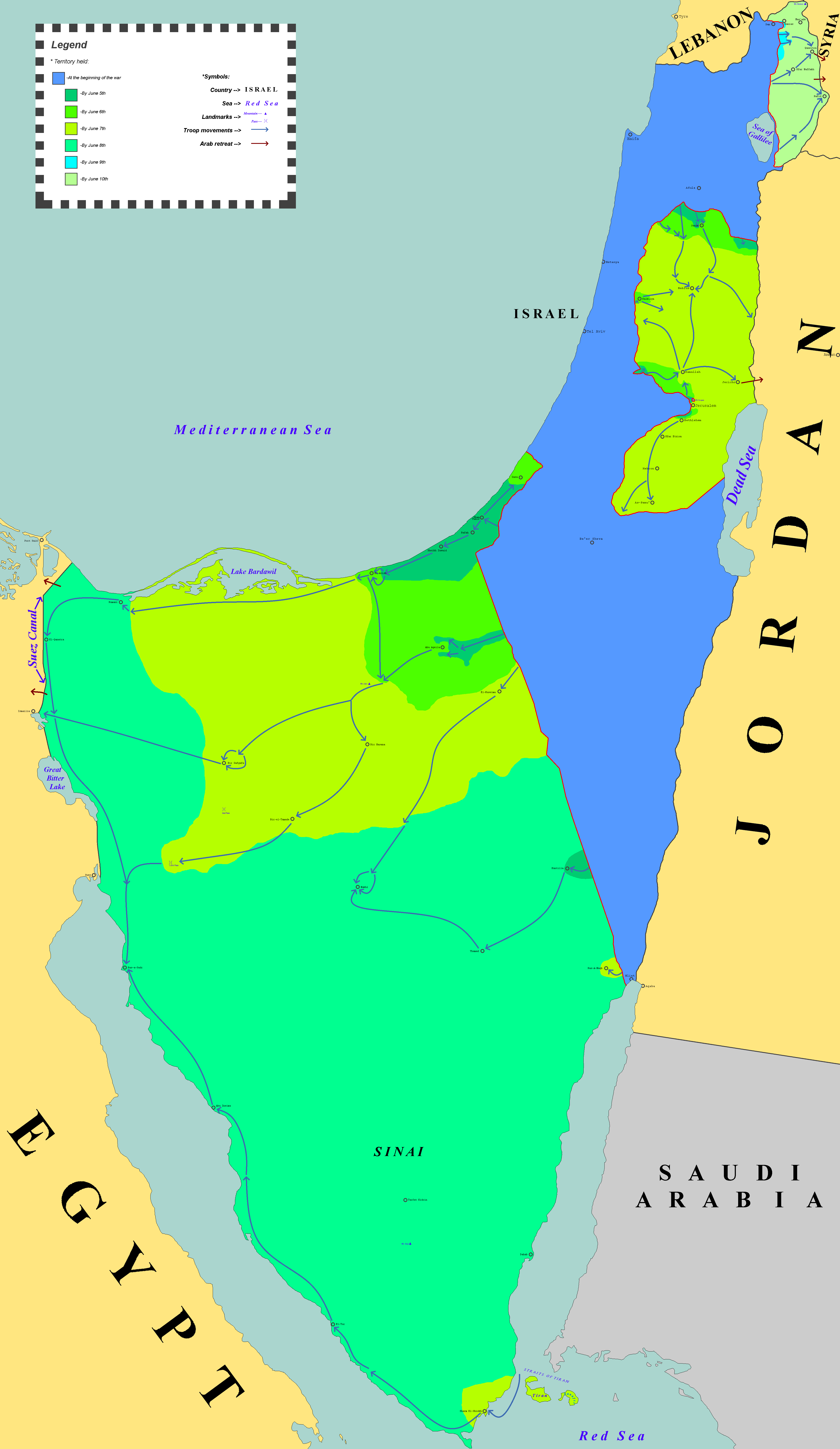
The Six-Day War (, ; ar, ž¦┘ä┘å┘āž│ž®, , or ) or June War, also known as the 1967 ArabŌĆōIsraeli War or Third ArabŌĆōIsraeli War, was fought between Israel and a coalition of Arab world, Arab states (primarily United Arab Republic, Egypt, Syria, and Jordan) from 5 to 10 June 1967. Escalated hostilities broke out amid poor relations between Israel and its Arab neighbours following the 1949 Armistice Agreements, which were signed at the end of the 1948 ArabŌĆōIsraeli War, First ArabŌĆōIsraeli War. Earlier, in 1956, regional tensions over the Straits of Tiran escalated in what became known as the Suez Crisis, when Israel invaded Egypt over the Israeli passage through the Suez Canal and Straits of Tiran, Egyptian closure of maritime passageways to Israeli shipping, ultimately resulting in the re-opening of the Straits of Tiran to Israel as well as the deployment of the United Nations Emergency Force (UNEF) along the Borders of Israel#Border with Egypt, EgyptŌĆōIsrael border. In ... [...More Info...] [...Related Items...] OR: [Wikipedia] [Google] [Baidu] |


