|
M4 (Copenhagen Metro)
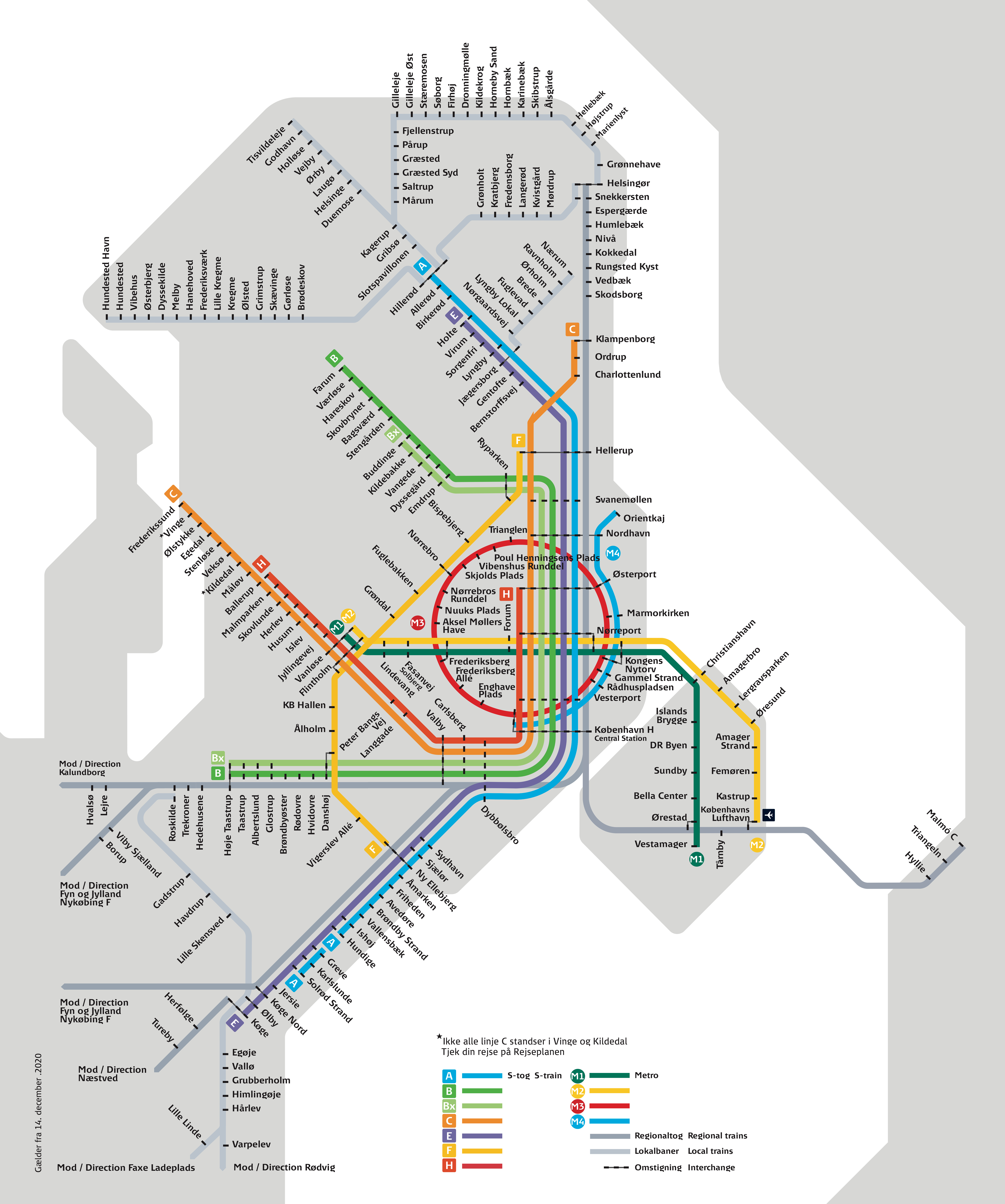
The M4 (the Harbour Line) of the Copenhagen Metro connects Nordhavn in the north with Sydhavn in the south. The central part of the line shares tracks with the City Circle Line (M3). The Nordhavn branch was approved by the Danish Parliament in 2012 and was opened on 28 March 2020. The Sydhavn branch was approved in 2015 and is expected to open in 2024. Both Nordhavn and Sydhavn are former industrial areas situated at opposite ends of the Port of Copenhagen and currently undergoing urban renewal under the auspices of By & Havn. When the City Circle Line was planned, the M4 was intended to supplement the M3 from Nørrebro to København H providing increased metro capacity to the eastern section of the inner city. At this time, it was presumed that the M4 would eventually be expanded from Nørrebro to the northwestern suburbs, but this plan was abandoned in 2009, when the city of Copenhagen scrapped plans for an interchange facility under Nørrebro station. Instead, the city pref ... [...More Info...] [...Related Items...] OR: [Wikipedia] [Google] [Baidu] |
Rapid Transit
Rapid transit or mass rapid transit (MRT), also known as heavy rail or metro, is a type of high-capacity public transport generally found in urban areas. A rapid transit system that primarily or traditionally runs below the surface may be called a subway, tube, or underground. Unlike buses or trams, rapid transit systems are railways (usually electric railway, electric) that operate on an exclusive right-of-way (transportation), right-of-way, which cannot be accessed by pedestrians or other vehicles, and which is often grade-separated in tunnels or on elevated railways. Modern services on rapid transit systems are provided on designated lines between rapid transit station, stations typically using electric multiple units on rail tracks, although some systems use guided rubber tires, magnetic levitation (''maglev''), or monorail. The stations typically have high platforms, without steps inside the trains, requiring custom-made trains in order to minimize gaps between train a ... [...More Info...] [...Related Items...] OR: [Wikipedia] [Google] [Baidu] |
Indre By
Indre By (lit. English, "Inner City"), also known as Copenhagen Center or K or Downtown Copenhagen, is an administrative district (''by'') in central Copenhagen, the capital of Denmark. It covers an area of , has a population of 26,223, and a population density of 5,638 per km². Neighboring city districts are as follows: * to the east and south east is Christianshavn, separated from the Inner City by the Inner Harbour (''Inderhavnen'') and Copenhagen Harbour (''Københavns Havn'') * to the north is Indre Østerbro * to the west is Indre Nørrebro and Frederiksberg municipality, which is not a part of Copenhagen municipality but rather an enclave surrounded by the municipality, with both being separated from the Indre By along the "lakes" (Skt. Jørgens Lake, Peblinge Lake, and Sortedams Lake) * to the southwest is Vesterbro * to the south is Vestamager, separated from the Inner City by the South Harbour (''Sydhavnen'') The Indre By district This district is the historic, ge ... [...More Info...] [...Related Items...] OR: [Wikipedia] [Google] [Baidu] |
Havneholmen Station
Havneholmen (literally "The Harbour Isle") is a mixed-use development located on reclaimed land off Kalvebod Brygge in the harbor of Copenhagen, Denmark. It is located just east of the shopping centre Fisketorvet from which it is separated by a narrow canal, although it is annexed to mainland Kalvebod Brygge at its southern end. Havneholmen is connected to Islands Brygge on the other side of the harbor by Brygge Bridge, a foot and cycling bridge. Tømmergraven Canal separates it from Enghave Brygge to the south. Construction The area was formerly known as Kalvebod Pladsvej and was an industrial site. The plan for its redevelopment was adopted by the City in 2003. A masterplan for the area was created by Gert Wingårdh and construction began in 2006. The development comprises about 91,000 square metres of buildings. It consists of a mixture of housing, offices and a hotel. Buildings The Havneholmen Housing Estate was built by Sjælsø Group between 2005 and 2009. It was designed ... [...More Info...] [...Related Items...] OR: [Wikipedia] [Google] [Baidu] |
DSB (railway Company)
DSB, an abbreviation of ''Danske Statsbaner'' (, ''Danish State Railways''), is the largest Danish train operating company, and the largest in Scandinavia. While DSB is responsible for passenger train operation on most of the Danish railways, goods transport and railway maintenance are outside its scope. DSB runs a commuter rail system, called the S-train, in the area around the Danish capital, Copenhagen, that connects the different areas and suburbs in the greater metropolitan area. Between 2010 and 2017, DSB operated trains in Sweden. DSB was founded in 1885 when the state-owned companies ''De jysk-fynske Statsbaner'' and ''De sjællandske Statsbaner'' merged. History The first railways in Denmark were built and operated by private companies. The railways in Funen and Jutland were built by Peto and Betts who also supplied the locomotives (built by Canada Works, Birkenhead). Most of the technical staff was also recruited from Britain, notably from the Eastern Counties Railway. ... [...More Info...] [...Related Items...] OR: [Wikipedia] [Google] [Baidu] |
S-train (Copenhagen)
The Copenhagen S-train ( da, S-tog), the S-train of Copenhagen, Denmark is a key part of public transport in the city. It is a hybrid urban- suburban rail serving most of the Copenhagen urban area, and is analogous to S-Bahn systems of Berlin, Vienna and Hamburg. The trains connect the Copenhagen inner city with Hillerød, Klampenborg, Frederikssund, Farum, Høje Taastrup and Køge. There are 170 km of double track with 86 S-train stations, of which eight are in neighbouring towns outside greater Copenhagen. The S-train is run by DSB S-tog A/S while Banedanmark owns the tracks and signals. Rail services are operated by "Fourth Generation" S-trains divided into 104 8-car train sets (Class SA) and 31 4-car train sets (Class SE). The system operates in tandem with the separately owned Copenhagen Metro which operates in the city centre, Frederiksberg and Amager. The two systems carry 500,000 passengers daily with S-tog serving more than 357,000 passengers a day. S-tog is com ... [...More Info...] [...Related Items...] OR: [Wikipedia] [Google] [Baidu] |
City Hall Square, Copenhagen
City Hall Square ( da, Rådhuspladsen, ) is a public square in the centre of Copenhagen, Denmark, located in front of the Copenhagen City Hall. Its large size, central location, and affiliation with the city hall makes it a popular venue for a variety of events, celebrations and demonstrations. It is often used as a central point for measuring distances from Copenhagen. City Hall Square is located at the southwestern end of the pedestrian street Strøget which connects it to Kongens Nytorv, the other large square of the city centre, passing Gammeltorv/Nytorv and Amagertorv along the way. Opposite Strøget, Vesterbrogade extends into the Vesterbro district and later crosses the border to Frederiksberg. H. C. Andersens Boulevard, Copenhagen's most heavily congested street, and Vester Voldgade pass the square on either side of the city hall. Apart from the City Hall, notable buildings around the square include Politikens Hus, the headquarters of national daily newspaper Politik ... [...More Info...] [...Related Items...] OR: [Wikipedia] [Google] [Baidu] |
Rådhuspladsen Station
City Hall Square ( da, Rådhuspladsen, ) is a public square in the centre of Copenhagen, Denmark, located in front of the Copenhagen City Hall. Its large size, central location, and affiliation with the city hall makes it a popular venue for a variety of events, celebrations and demonstrations. It is often used as a central point for measuring distances from Copenhagen. City Hall Square is located at the southwestern end of the pedestrian street Strøget which connects it to Kongens Nytorv, the other large square of the city centre, passing Gammeltorv/Nytorv and Amagertorv along the way. Opposite Strøget, Vesterbrogade extends into the Vesterbro district and later crosses the border to Frederiksberg. H. C. Andersens Boulevard, Copenhagen's most heavily congested street, and Vester Voldgade pass the square on either side of the city hall. Apart from the City Hall, notable buildings around the square include Politikens Hus, the headquarters of national daily newspaper Politike ... [...More Info...] [...Related Items...] OR: [Wikipedia] [Google] [Baidu] |
Christiansborg Palace
Christiansborg Palace ( da, Christiansborg Slot; ) is a palace and government building on the islet of Slotsholmen in central Copenhagen, Denmark. It is the seat of the Danish Parliament ('), the Danish Prime Minister's Office, and the Supreme Court of Denmark. Also, several parts of the palace are used by the Danish monarch, including the Royal Reception Rooms, the Palace Chapel and the Royal Stables. The palace is thus home to the three supreme powers: the executive power, the legislative power, and the judicial power. It is the only building in the world that houses all three of a country's branches of government. The name Christiansborg is thus also frequently used as a metonym for the Danish political system, and colloquially it is often referred to as ''Rigsborgen'' ('the castle of the realm') or simply ''Borgen'' ('the castle'). The present building, the third with this name, is the last in a series of successive castles and palaces constructed on the same site since th ... [...More Info...] [...Related Items...] OR: [Wikipedia] [Google] [Baidu] |
Gammel Strand Station
Gammel Strand station (, lit. ''Old Beach'') is a Copenhagen Metro station located at Gammel Strand in the Old Town of Copenhagen, Denmark. The station is on the City Circle Line (M3 and M4), between Kongens Nytorv and Rådhuspladsen, and is in fare zone 1. The station provides access to the central section of Strøget, Slotsholmen, Christiansborg Palace and Højbro Plads. History Construction on the station began in 2009. It was opened on 29 September 2019 along with the rest of the City Circle Line. Design The station is constructed underneath Slotsholmen Canal. The main entrance faces Højbro Plads Højbro Plads (literally "High Bridge Square") is a rectangular public square located between the adjoining Amagertorv and Slotsholmen Canal in the City Centre of Copenhagen, Denmark. It takes its name from the Højbro Bridge which connects it t .... The escalator is longer than those of the other stations. The walls are faced with a combination of glazed and unglazed pale, ce ... [...More Info...] [...Related Items...] OR: [Wikipedia] [Google] [Baidu] |
Frederik's Church
Frederik's Church ( da, Frederiks Kirke), popularly known as The Marble Church () for its rococo architecture, is an Church of Denmark, Evangelical Lutheran church in Copenhagen, Denmark. The church forms the focal point of the Frederiksstaden district; it is located due west of Amalienborg Palace. History and description The church was designed by the architect Nicolai Eigtved in 1740 and was along with the rest of Frederiksstaden, a district of Copenhagen, intended to commemorate the 300 years jubilee of the first coronation of a member of the House of Oldenburg.Marble Church Copenhagen - Copenhagen Tourist - Copenhagenet.dk. Retrieved 27 May 2012 Frederick's Church has the largest church dome in Scandinavia with a span of 31m. The dome rests on 12 columns. The inspiration was probably St. Peter's Basilic ... [...More Info...] [...Related Items...] OR: [Wikipedia] [Google] [Baidu] |


