|
Mumbai's Water Sources
Mumbai controls several dams in Shahpur taluk (Thane district) that deliver water to the city. The Western Ghats trap most of the moisture laden monsoon clouds which feed these dammed rivers. Currently, these dams deliver approximately 3.4 billion litres of water to Mumbai daily. Here are the dams supplying the city the water it needs to survive: Tansa and Vaitarna dams supply the southern region of Mumbai, while the rest supply the suburbs. An underground tank in Malabar Hill Malabar Hill (ISO: Malabār Hill ələbaːɾ is a hillock and upmarket residential neighbourhood in South Mumbai, Maharashtra, India. Malabar Hill is the most exclusive residential area in Mumbai. It is home to several business tycoons and f ...s is used to store the water. References Geography of Mumbai Water supply and sanitation in India {{Maharashtra-stub ... [...More Info...] [...Related Items...] OR: [Wikipedia] [Google] [Baidu] |
Mumbai
Mumbai (, ; also known as Bombay — the official name until 1995) is the capital city of the Indian state of Maharashtra and the ''de facto'' financial centre of India. According to the United Nations, as of 2018, Mumbai is the second-most populous city in India after Delhi and the eighth-most populous city in the world with a population of roughly 20 million (2 crore). As per the Indian government population census of 2011, Mumbai was the most populous city in India with an estimated city proper population of 12.5 million (1.25 crore) living under the Brihanmumbai Municipal Corporation. Mumbai is the centre of the Mumbai Metropolitan Region, the sixth most populous metropolitan area in the world with a population of over 23 million (2.3 crore). Mumbai lies on the Konkan coast on the west coast of India and has a deep natural harbour. In 2008, Mumbai was named an alpha world city. It has the highest number of millionaires and billionaires among all cities i ... [...More Info...] [...Related Items...] OR: [Wikipedia] [Google] [Baidu] |
Shahapur Taluka
Shahapur taluka is a taluka in Thane district of Maharashtra in Konkan division. Thane district Until 31 July 2014, Thane was the country's most populous district with a population of over 1.2 crore. On 1 August 2014, the talukas of Mokhada, Jawahar, Talasari, Vikramgadh, Wada, Dahanu, Palghar and Vasai were separated from the erstwhile Thane district to form a new district Palghar. The talukas Thane, Bhiwandi, Kalyan, Ulhasnagar, Ambernath, Murbad Murbad is a census town within the administrative division (taluka) of Thane district in the Indian state of Maharashtra. Murbad city with its neighbouring villages jointly form the Murbad nagar panchayat, which is near the cities of Thane, Kar ... and Shahapur were retained in Thane district. References Talukas in Thane district Talukas in Maharashtra {{Thane-geo-stub ... [...More Info...] [...Related Items...] OR: [Wikipedia] [Google] [Baidu] |
Thane District
Thane district (Pronunciation: �ʰaːɳe previously named Taana or Thana) is a district in the Konkan Division of Maharashtra, India. At the 2011 Census it was the most populated district in the country, with 11,060,148 inhabitants; however, in August 2014 the district was split into two with the creation of a new Palghar district, leaving the reduced Thane district with a 2011 Census population of 8,070,032. The headquarters of the district is the city of Thane. Other major cities in the district are Navi Mumbai, Kalyan-Dombivli, Mira-Bhayander, Bhiwandi, Ulhasnagar, Ambarnath, Badlapur, Murbad and Shahapur. The district is situated between 18°42' and 20°20' north latitudes and 72°45' and 73°48' east longitudes. The revised area of the district is 4,214 km2. The district is bounded by Nashik district to the north east, Pune and Ahmednagar districts to the east, and by Palghar district to the north. The Arabian Sea forms the western boundary, while it is bounded by M ... [...More Info...] [...Related Items...] OR: [Wikipedia] [Google] [Baidu] |
Monsoon
A monsoon () is traditionally a seasonal reversing wind accompanied by corresponding changes in precipitation but is now used to describe seasonal changes in atmospheric circulation and precipitation associated with annual latitudinal oscillation of the Intertropical Convergence Zone (ITCZ) between its limits to the north and south of the equator. Usually, the term monsoon is used to refer to the rainy phase of a seasonally changing pattern, although technically there is also a dry phase. The term is also sometimes used to describe locally heavy but short-term rains. The major monsoon systems of the world consist of the West African, Asia–Australian, the North American, and South American monsoons. The term was first used in English in British India and neighboring countries to refer to the big seasonal winds blowing from the Bay of Bengal and Arabian Sea in the southwest bringing heavy rainfall to the area. Etymology The etymology of the word monsoon is not wholl ... [...More Info...] [...Related Items...] OR: [Wikipedia] [Google] [Baidu] |
Modak Sagar
Modak Sagar is a lake located in Thane district on the Vaitarna River. It has an overflow level of 163.15 meters, making it the second largest of the lakes supplying water to the city of Mumbai Mumbai (, ; also known as Bombay — the official name until 1995) is the capital city of the Indian state of Maharashtra and the ''de facto'' financial centre of India. According to the United Nations, as of 2018, Mumbai is the second- .... History Special engineer Mr. N.V.Modak also known as Nanasaheb Modak, who designed and executed Mumbai's Marine drive was the author of 'Outline of the master plan for Greater Bombay' which is still in the archives of Municipal Corporation of Greater Mumbai. To solve the potable water supply issue for Mumbai, he took up the project and inspected all the three districts of Nashik, Pune and Thane and found that the Vaitarna river flowing from Igatpuri in Nashik district to Khardi in Thane district has a good flow of water. They built a da ... [...More Info...] [...Related Items...] OR: [Wikipedia] [Google] [Baidu] |
Vihar Lake
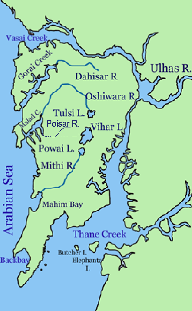
Vihar Lake (Pronunciation: �iɦaːɾ is located near Vihar village on the Mithi River within the precincts of the Borivali National Park, also called the Sanjay Gandhi National Park, in North Mumbai. When built in 1860 (construction started in 1856), it was considered as the largest lake in Mumbai in the Salsette group of islands. It is hemmed between the Tulsi Lake and the Powai Lake (shown in map). It partly meets the drinking water needs of the Mumbai region. Bombay water supply history It supplies only 3% of the Mumbai city's water requirement, after filtration at Bhandup where the large water filtration plant is located. History [...More Info...] [...Related Items...] OR: [Wikipedia] [Google] [Baidu] |
Tulsi Lake
Tulsi Lake is a fresh water lake in northern Mumbai. It is stated to be the second largest lake in Mumbai and supplies part of the city's potable water. This is one of the three lakes located in the Salsette Island; the other two being Powai Lake and Vihar Lake. Both Tulsi lake and Vihar lake are located within the densely forested Sanjay Gandhi National Park or also known popularly as the Borivali National Park (BNP). Hydrology Tulsi Lake was built by damming the River Tasso, and redirecting the flow to the nearby Vihar Lake. Rain water from the catchment area of 676 hectares of Powai-Kanheri hill ranges drains into the lake. During the rainy season the flood flows out flows into the Powai Lake and further down into the Mithi River. The maximum height of hill in the catchment is about 400 m. The southwest monsoon sets in by mid June and lasts till September. The maximum rainfall is normally recorded in the months of July and August. The mean annual rainfall is reported to ... [...More Info...] [...Related Items...] OR: [Wikipedia] [Google] [Baidu] |
Upper Vaitarana Dam
Upper Vaitarana Dam, is an earthfill and gravity dam on west flowing Vaitarna river near Igatpuri, Nashik district of Maharashtra state in India. The reservoir created by this dam spreads on both Vaitarna and Godavari rivers catchment area. Specifications The height of the dam above its lowest foundation is while the length is . The volume content is and live storage capacity is . Purpose * Municipal water supply to Mumbai city and hydroelectricity (60 MW). See also * Vaitarna Dam * Middle Vaitarna Dam * Dams in Maharashtra * List of reservoirs and dams in India This page shows the state-wise list of dams and reservoirs in India. As of July, 2019, total number of large dams in India is 5,334. About 447 large dams are under construction in India. In terms of number of dams, India ranks third after China an ... References {{reflist Dams in Nashik district Dams completed in 1973 1973 establishments in Maharashtra ... [...More Info...] [...Related Items...] OR: [Wikipedia] [Google] [Baidu] |
Bhatsa
Bhatsa Dam, is an earthfill and gravity dam on Bhatsa river near Shahapur, Thane district in state of Maharashtra in India. Specifications The height of the dam above lowest foundation is while the length is . The volume content is and gross storage capacity is . Purpose * Irrigation – Bhatsa dam has Right bank canal and Left bank canal for irrigation. However, only Right bank canal is functional which flows through Bhiwandi Taluka. * Water supply – Bhatsa dam is the major source of water for MCGM (Municipal Corporation of Greater Mumbai) and TMC (Thane Municipal Corporation). The water for both the municipal corporations is pumped from Pise Dam which is 50 km away from Bhatsa dam on Bhatsa river. Water for K ...[...More Info...] [...Related Items...] OR: [Wikipedia] [Google] [Baidu] |
Middle Vaitarna
Middle or The Middle may refer to: * Centre (geometry), the point equally distant from the outer limits. Places * Middle (sheading), a subdivision of the Isle of Man * Middle Bay (other) * Middle Brook (other) * Middle Creek (other) * Middle Island (other) * Middle Lake (other) * Middle Mountain, California * Middle Peninsula, Chesapeake Bay, Virginia * Middle Range, a former name of the Xueshan Range on Taiwan Island * Middle River (other) * Middle Rocks, two rocks at the eastern opening of the Straits of Singapore * Middle Sound, a bay in North Carolina * Middle Township (other) * Middle East Music * "Middle" (song), 2015 * "The Middle" (Jimmy Eat World song), 2001 * "The Middle" (Zedd, Maren Morris and Grey song), 2018 *"Middle", a song by Rocket from the Crypt from their 1995 album ''Scream, Dracula, Scream!'' *"The Middle", a song by Demi Lovato from their debut album ''Don't Forget'' *"The Middle", a song by T ... [...More Info...] [...Related Items...] OR: [Wikipedia] [Google] [Baidu] |


