|
Moabi Airport
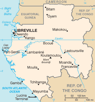
Moabi Airport (French: ''Aéroport Moabi'') is an airport serving the town of Moabi in the Nyanga Province of Gabon. See also * * List of airports in Gabon * Transport in Gabon Modes of transport in Gabon include rail, road, water, and air. The one rail link, the Trans-Gabon Railway, connects the port of Owendo with the inland town of Franceville. Most but not all of the country is connected to the road network, much of ... References External linksGoogle Maps - Moabi Airports in Gabon {{Gab ... [...More Info...] [...Related Items...] OR: [Wikipedia] [Google] [Baidu] |
Moabi (Gabon)
Moabi may refer to: * Moabi (Gabon), the capital of Douigni, Gabon ** Moabi Airport * Commune of Moabi, a commune of Gabon * '' Baillonella toxisperma'', a tropical tree See also * Moab (other) Moab is the historical name for an ancient kingdom whose former territory is located in modern-day Jordan. Moab or MOAB may also refer to: Places * Moab, Utah, a United States city * Newman Lake, Washington, an unincorporated community alternat ... * Moabite (other) {{disambiguation ... [...More Info...] [...Related Items...] OR: [Wikipedia] [Google] [Baidu] |
Nyanga Province
Nyanga is the southernmost of Gabon's nine provinces. The provincial capital is Tchibanga, which had a total of 31294 inhabitants in 2013 (more than the half of the province population). Nyanga is the least populated province of the nine and the other least developed, besides Ogooué-Ivindo. It is bordered by Ogooué-Maritime in the northwest, Ngounié in the north, and the Congo to the south (Kouilou Region) and east (Niari Region). The Atlantic Ocean—the lowest point in both Gabon and Nyanga Province—borders it in the west. Departments Nyanga is divided into 6 departments: * Basse-Banio Department (Mayumba) *Douigni Department ( Moabi) * Doutsila Department (Mabanda) * Haute-Banio Department (Ndindi) * Mongo Department (Moulengui-Binza) * Mougoutsi Department (Tchibanga) Statistics *Area: 21,285 km² *2-letter abbreviation/HASC: GA-NY *ISO 3166-2 ISO 3166-2 is part of the ISO 3166 standard published by the International Organization for Standardization (ISO ... [...More Info...] [...Related Items...] OR: [Wikipedia] [Google] [Baidu] |
Gabon
Gabon (; ; snq, Ngabu), officially the Gabonese Republic (french: République gabonaise), is a country on the west coast of Central Africa. Located on the equator, it is bordered by Equatorial Guinea to the northwest, Cameroon to the north, the Republic of the Congo on the east and south, and the Gulf of Guinea to the west. It has an area of nearly and its population is estimated at million people. There are coastal plains, mountains (the Cristal Mountains and the Chaillu Massif in the centre), and a savanna in the east. Since its independence from France in 1960, the sovereign state of Gabon has had three presidents. In the 1990s, it introduced a multi-party system and a democratic constitution that aimed for a more transparent electoral process and reformed some governmental institutions. With petroleum and foreign private investment, it has the fourth highest HDI in the region (after Mauritius, Seychelles and South Africa) and the fifth highest GDP per capita (PPP) i ... [...More Info...] [...Related Items...] OR: [Wikipedia] [Google] [Baidu] |
List Of Airports In Gabon ...
This is a list of airports in Gabon, sorted by location. __TOC__ List See also * Transport in Gabon * List of airports by ICAO code: F#FO – Gabon * Wikipedia: WikiProject Aviation/Airline destination lists: Africa#Gabon References * * External links Great Circle MapperWorld Aero Data {{Airports in Gabon, state=collapsed Gabon Airports Airports Gabon Gabon (; ; snq, Ngabu), officially the Gabonese Republic (french: République gabonaise), is a country on the west coast of Central Africa. Located on the equator, it is bordered by Equatorial Guinea to the northwest, Cameroon to the north ... [...More Info...] [...Related Items...] OR: [Wikipedia] [Google] [Baidu] |
Transport In Gabon
Modes of transport in Gabon include rail, road, water, and air. The one rail link, the Trans-Gabon Railway, connects the port of Owendo with the inland town of Franceville. Most but not all of the country is connected to the road network, much of which is unpaved, and which centres on seven "national routes" identified as N1 to N7. The largest seaports are Port-Gentil and the newer Owendo, and 1,600 km of inland waterways are navigable. There are three international airports, eight other paved airports, and over 40 with unpaved runways. Nearly 300 km of pipelines carry petroleum products, mainly crude oil. Rail transport Until the 1970s Gabon had no permanent railroads, though temporary Decauville rail tracks were in use in the logging industry as early as 1913 (Gray and Ngolet, 1999, pp.102). In 2003, the railway began the process of installing a satellite based telecommunications system. As of 2004, Gabon State Railways totalled 814 km of standard-gauge track. ... [...More Info...] [...Related Items...] OR: [Wikipedia] [Google] [Baidu] |
.png)
