|
Mašelj
Mašelj (; in older sources also ''Mašlje'',''Leksikon občin kraljestev in dežel zastopanih v državnem zboru,'' vol. 6: ''Kranjsko''. 1906. Vienna: C. Kr. Dvorna in Državna Tiskarna, p. 152. german: MaschelFerenc, Mitja. 2007. ''Nekdanji nemški jezikovni otok na kočevskem''. Kočevje: Pokrajinski muzej, p. 4. or ''Maschen'') is a small settlement in the Municipality of Semič in Slovenia. The area is part of the historical region of Lower Carniola. The municipality is now included in the Southeast Slovenia Statistical Region The Southeast Slovenia Statistical Region ( sl, Jugovzhodna Slovenija statistična regija) is a statistical region in southeast Slovenia. It is the largest statistical region. The development of this region is largely the result of industry (the au .... Mašelj is known locally as ''Graben''.Savnik, Roman, ed. 1971. ''Krajevni leksikon Slovenije'', vol. 2. Ljubljana: Državna založba Slovenije, p. 45. The settlement has no permanent residents today. Hi ... [...More Info...] [...Related Items...] OR: [Wikipedia] [Google] [Baidu] |
Gottschee County
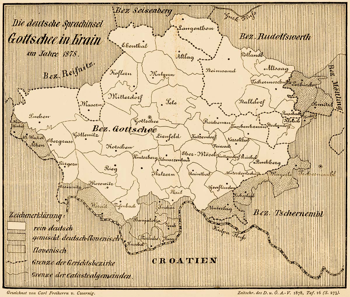
Gottschee (, sl, Kočevsko) refers to a former German-speaking region in Carniola, a crownland of the Habsburg Empire, part of the historical and traditional region of Lower Carniola, now in Slovenia. The region has been a county, duchy, district, and municipality during various parts of its history. The term often also refers to the entire ethnolinguistic enclave regardless of administrative borders. Today Gottschee largely corresponds to the Municipality of Kočevje. The original German settlers of the region are called Gottschee Germans or Gottscheers, and their German dialect is called Gottschee German or Gottscheerish. Geography The Gottschee enclave encompassed a roughly oval-shaped area between 45° 46′ N and 45° 30′ N, and between 14° 36′ E and 15° 9′ E. Geographers divided the enclave into seven regions based on valleys (from west to east): * The Suchen Plateau () in the extreme west, with the (pre-1933) municipalities of Obergras and Suchen; * The Back Dist ... [...More Info...] [...Related Items...] OR: [Wikipedia] [Google] [Baidu] |
Municipality Of Semič
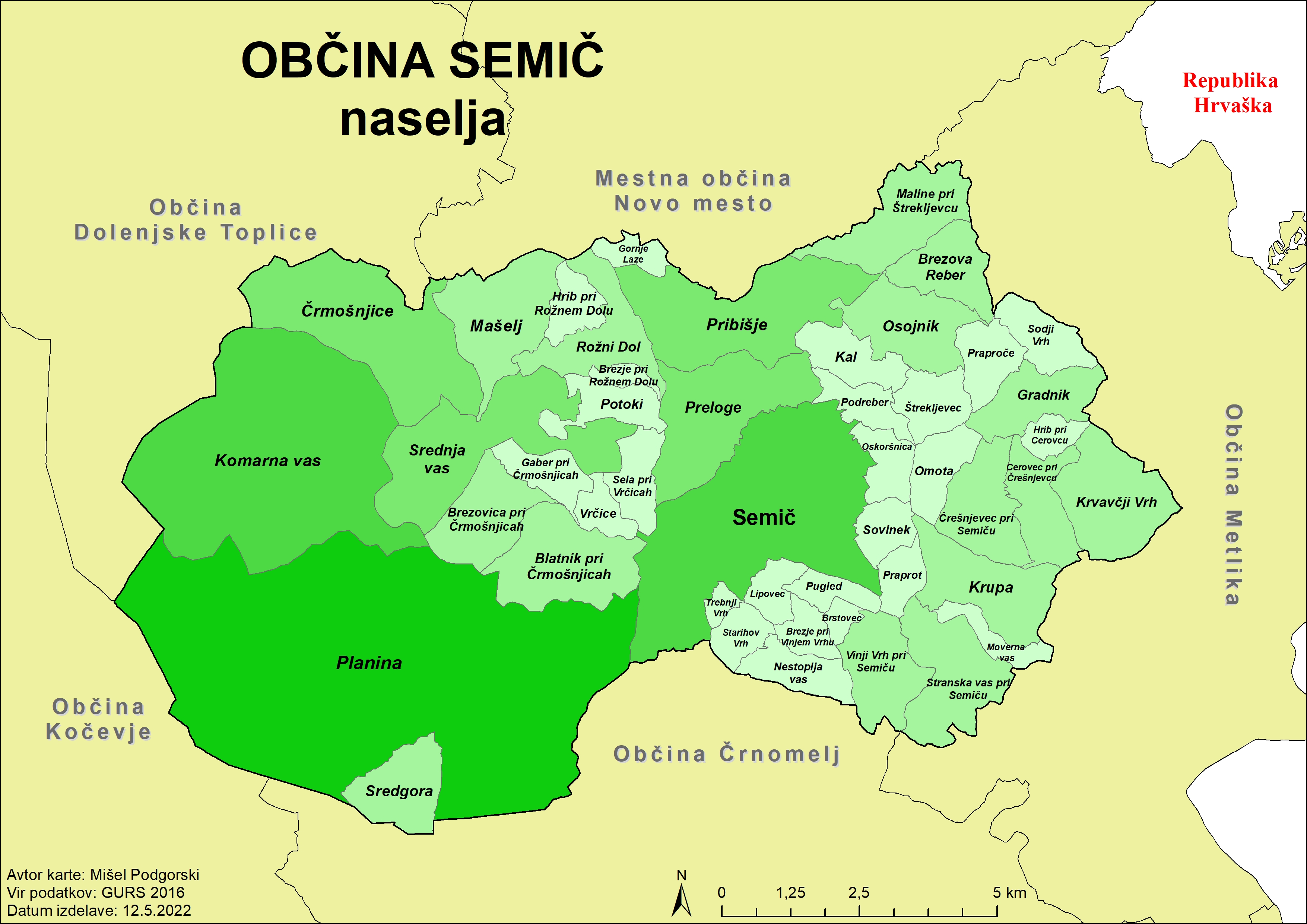
The Municipality of Semič (; sl, Občina Semič) is a municipality in Slovenia in the traditional region of White Carniola in southeastern Slovenia. The municipality is included in the Southeast Slovenia Statistical Region. Its seat is the settlement of Semič. Settlements In addition to the municipal seat of Semič, the municipality also includes the following settlements: * Blatnik pri Črmošnjicah * Brezje pri Rožnem Dolu * Brezje pri Vinjem Vrhu * Brezova Reber * Brezovica pri Črmošnjicah * Brstovec * Cerovec pri Črešnjevcu * Črešnjevec pri Semiču * Črmošnjice * Gaber pri Črmošnjicah * Gornje Laze * Gradnik * Hrib pri Cerovcu * Hrib pri Rožnem Dolu * Kal * Komarna Vas * Krupa * Krvavčji Vrh * Lipovec * Maline pri Štrekljevcu * Mašelj * Moverna Vas * Nestoplja Vas * Omota Omota () is a small settlement in the Municipality of Semič in Slovenia. It lies northeast of Semič, just off the local road to Gradnik. The area is part of the historical ... [...More Info...] [...Related Items...] OR: [Wikipedia] [Google] [Baidu] |
Flag Of Slovenia
The national flag of Slovenia ( sl, zastava Slovenije) features three equal horizontal bands of white (top), blue, and red, with the Coat of arms of Slovenia located in the upper hoist side of the flag centered in the white and blue bands. The coat of arms is a shield with the image of Mount Triglav, Slovenia's highest peak, in white against a blue background at the center; beneath it are two wavy blue lines representing the Adriatic Sea and local rivers, and above it are three six-pointed golden stars arranged in an inverted triangle which are taken from the coat of arms of the Counts of Celje, the great Slovene dynastic house of the late 14th and early 15th centuries. The flag's colors are considered to be Pan-Slavism, Pan-Slavic, but they actually come from the Middle Ages, medieval coat of arms of the Duchy of Carniola, consisting of 3 stars, a mountain, and three colors (red, blue, yellow). crescent. The existing Slovene tricolor was raised for the first time in history duri ... [...More Info...] [...Related Items...] OR: [Wikipedia] [Google] [Baidu] |
Slovenia
Slovenia ( ; sl, Slovenija ), officially the Republic of Slovenia (Slovene: , abbr.: ''RS''), is a country in Central Europe. It is bordered by Italy to the west, Austria to the north, Hungary to the northeast, Croatia to the southeast, and the Adriatic Sea to the southwest. Slovenia is mostly mountainous and forested, covers , and has a population of 2.1 million (2,108,708 people). Slovenes constitute over 80% of the country's population. Slovene, a South Slavic language, is the official language. Slovenia has a predominantly temperate continental climate, with the exception of the Slovene Littoral and the Julian Alps. A sub-mediterranean climate reaches to the northern extensions of the Dinaric Alps that traverse the country in a northwest–southeast direction. The Julian Alps in the northwest have an alpine climate. Toward the northeastern Pannonian Basin, a continental climate is more pronounced. Ljubljana, the capital and largest city of Slovenia, is geogr ... [...More Info...] [...Related Items...] OR: [Wikipedia] [Google] [Baidu] |
Lower Carniola
Lower Carniola ( sl, Dolenjska; german: Unterkrain) is a traditional region in Slovenia, the southeastern part of the historical Carniola region. Geography Lower Carniola is delineated by the Ljubljana Basin with the city of Ljubljana to the northwest, by the Kolpa River and the border with Croatia with the Gorjanci Mountains to the south and southeast, by the Sava River to the north and northeast, and by Mount Krim, the Bloke Plateau, and the Potok Plateau ( sl, Potočanska planota) to the west. The southernmost region down to the border with Croatia on the Kolpa River is called White Carniola and usually considered part of Lower Carniola. Within the Kočevje Rog karst plateau, the mountains reach an elevation of up to . The historic centre of Lower Carniola is Novo Mesto, and other towns include Kočevje, Grosuplje, Krško, Trebnje, Mirna, Črnomelj, Semič, and Metlika. History In the 17th century, the Habsburg duchy of Carniola was internally divided into three admi ... [...More Info...] [...Related Items...] OR: [Wikipedia] [Google] [Baidu] |
Statistical Regions Of Slovenia
The statistical regions of Slovenia are 12 administrative entities created in 2000 for legal and statistical purposes. Division By a decree in 2000, Slovenia has been divided into 12 statistical regions ( NUTS-3 level), which are grouped in two cohesion regions (NUTS-2 level). which replace the historical regions of the country. The statistical regions have been grouped into two cohesion regions are: *Eastern Slovenia (''Vzhodna Slovenija'' – SI01), which groups the Mura, Drava, Carinthia, Savinja, Central Sava, Lower Sava, Southeast Slovenia, and Littoral–Inner Carniola regions. * Western Slovenia (''Zahodna Slovenija'' – SI02), which groups the Central Slovenia, Upper Carniola, Gorizia, and Coastal–Karst regions. Sources Slovenian regions in figures 2014 See also *List of Slovenian regions by Human Development Index *Municipalities of Slovenia Slovenia is divided into 212 municipalities ( Slovene: ''občine'', singular'' občina''), of which 12 have urban (metr ... [...More Info...] [...Related Items...] OR: [Wikipedia] [Google] [Baidu] |
Southeast Slovenia Statistical Region
The Southeast Slovenia Statistical Region ( sl, Jugovzhodna Slovenija statistična regija) is a statistical region in southeast Slovenia. It is the largest statistical region. The development of this region is largely the result of industry (the auto industry, pharmaceuticals, and other light industry), which generated nearly half of the gross value added in the region in 2012. According to the latest available data for 2013, 94% of waste water in the region was treated before it was discharged from the public sewage system. This is significantly more than in Slovenia as a whole (78%). The expenditure on research and development (R&D), which amounted to 5.2% of the regional GDP in 2012, highlights the importance of R&D in the region. Businesses accounted for 90% of the sources of financing. The population's age structure in this region is favourable. In mid-2013 the value of the ageing index was 105.2, which means that the ratio between the population 65 or older and the population 1 ... [...More Info...] [...Related Items...] OR: [Wikipedia] [Google] [Baidu] |
Municipalities Of Slovenia
Slovenia is divided into 212 municipalities ( Slovene: ''občine'', singular'' občina''), of which 12 have urban (metropolitan) status. Municipalities are further divided into local communities and districts. Slovene is an official language of all the municipalities. Hungarian is a second official language of three municipalities in Prekmurje: Dobrovnik/Dobronak, Hodoš/Hodos, and Lendava/Lendva. Italian is a second official language of four municipalities (of which one has urban status) in the Slovene Littoral The Slovene Littoral ( sl, Primorska, ; it, Litorale; german: Küstenland) is one of the five traditional regions of Slovenia. Its name recalls the former Austrian Littoral (''Avstrijsko Primorje''), the Habsburg possessions on the upper Adria ...: Ankaran/Ancarano, Izola/Isola, Koper/Capodistria, and Piran/Pirano. In the EU statistics, the municipalities of Slovenia are classified as "local administrative unit 2" (LAU 2), below 58 administrative units ('), which ... [...More Info...] [...Related Items...] OR: [Wikipedia] [Google] [Baidu] |
Črmošnjice, Semič
Črmošnjice (; german: Tschermoschnitz''Leksikon občin kraljestev in dežel zastopanih v državnem zboru,'' vol. 6: ''Kranjsko''. 1906. Vienna: C. Kr. Dvorna in Državna Tiskarna, p. 152.Ferenc, Mitja. 2007. ''Nekdanji nemški jezikovni otok na kočevskem''. Kočevje: Pokrajinski muzej, p. 4.) is a village in the Municipality of Semič in Slovenia. It lies on the eastern edge of the Gottschee region that used to be inhabited by Gottschee Germans expelled in 1941 during the Second World War. The area is part of the historical region of Lower Carniola. The municipality is now included in the Southeast Slovenia Statistical Region. Name Črmošnjice was first attested in 1264 as ''Scherczenicz'' (and as ''Zcermesniza'' in 1295, ''Tschermoznicz'' in 1353, and ''Tschermoschnitz'' in 1421). The name is derived from archaic Slovene ''čremoš, čremož'' 'ramsons' (today ''čemaž'' in Slovene) and thus refers to the local vegetation. The name of the town also appears in the clipped f ... [...More Info...] [...Related Items...] OR: [Wikipedia] [Google] [Baidu] |
Armistice Between Italy And Allied Armed Forces
The Armistice of Cassibile was an armistice signed on 3 September 1943 and made public on 8 September between the Kingdom of Italy and the Allies during World War II. It was signed by Major General Walter Bedell Smith for the Allies and Brigade General Giuseppe Castellano for Italy at a conference of generals from both sides in an Allied military camp at Cassibile, in Sicily, which had recently been occupied by the Allies. The armistice was approved by both the Italian King Victor Emmanuel III and Marshal Badoglio, the Prime Minister of Italy at the time. Germany moved rapidly by freeing Benito Mussolini (12 September) and attacking Italian forces in Italy (8–19 September), southern France and the Balkans. The Italian forces were quickly defeated, and most of Italy was occupied by German troops, who established a puppet state, the Italian Social Republic. The king, the Italian government, and most of the navy escaped to territories occupied by the Allies. Background Fo ... [...More Info...] [...Related Items...] OR: [Wikipedia] [Google] [Baidu] |
Yugoslav Partisans
The Yugoslav Partisans,Serbo-Croatian, Macedonian, Slovene: , or the National Liberation Army, sh-Latn-Cyrl, Narodnooslobodilačka vojska (NOV), Народноослободилачка војска (НОВ); mk, Народноослободителна војска (НОВ); sl, Narodnoosvobodilna vojska (NOV) officially the National Liberation Army and Partisan Detachments of Yugoslavia, sh-Latn-Cyrl, Narodnooslobodilačka vojska i partizanski odredi Jugoslavije (NOV i POJ), Народноослободилачка војска и партизански одреди Југославије (НОВ и ПОЈ); mk, Народноослободителна војска и партизански одреди на Југославија (НОВ и ПОЈ); sl, Narodnoosvobodilna vojska in partizanski odredi Jugoslavije (NOV in POJ) was the communist-led anti-fascist resistance to the Axis powers (chiefly Germany) in occupied Yugoslavia during World War II. Led by Josip Broz T ... [...More Info...] [...Related Items...] OR: [Wikipedia] [Google] [Baidu] |


