|
Lupane District
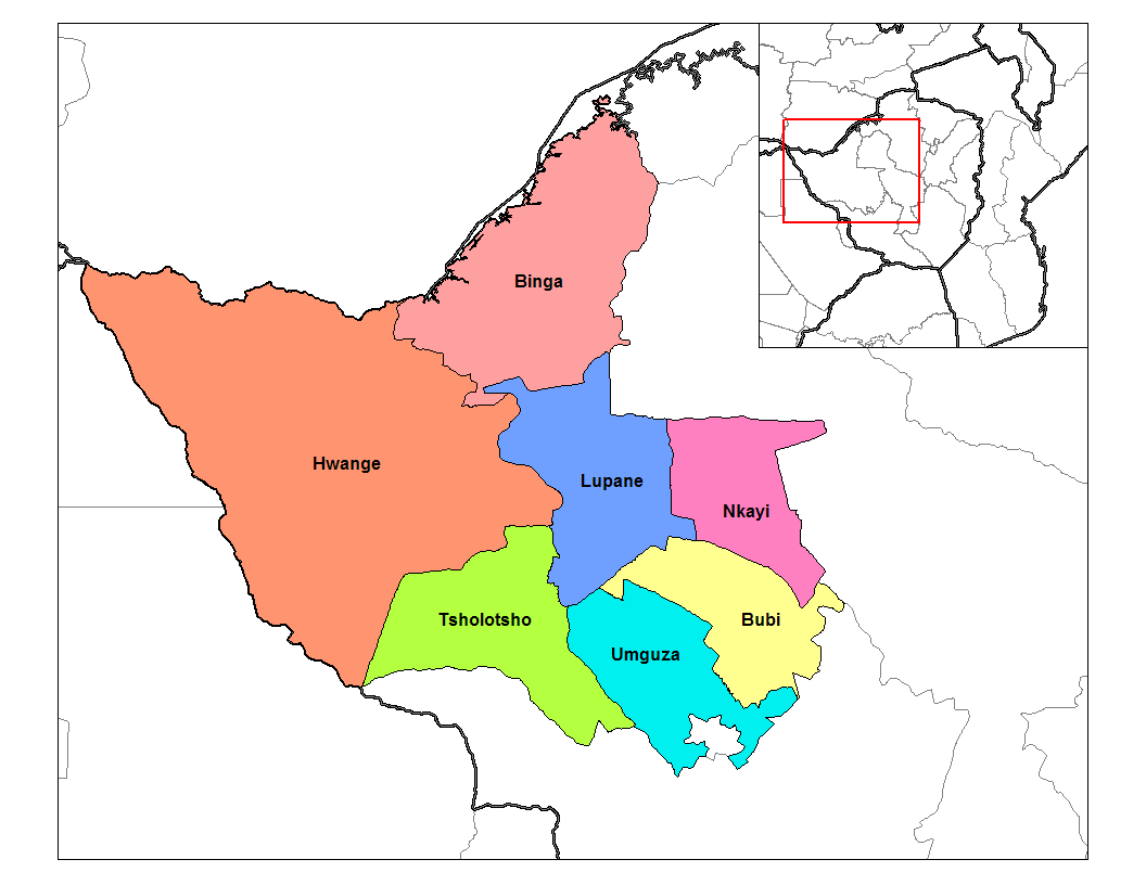
Lupane ( luːpɑːnɛ) District is located in the Matabeleland North Province of Zimbabwe, and it is also the Provincial Capital. The District is situated at an elevation of 976 m with a population of 198,600 inhabitants by 2019. Lupane Town is the main center of the district located 172 km from Bulawayo along the A8 Victoria Falls Road. The Government Provincial Administrative offices are located at the Town Centre. A new university near the Town has been established under the name Lupane State University, which caters for the region and beyond. The word Lupane is thought to be a Kalanga or Lozwi word. Geography Lupane is a rural semi-arid area with a growing population and some infrastructural expansion due to status of being accorded the capital of the province under government devolution. The area falls under Savannah climate with four seasons, the altitude rainfall patterns favours woodlands and grasslands depending on the location in the country. Climate Rains i ... [...More Info...] [...Related Items...] OR: [Wikipedia] [Google] [Baidu] |
Matabeleland North Districts
Matabeleland is a region located in southwestern Zimbabwe that is divided into three provinces: Matabeleland North, Bulawayo, and Matabeleland South. These provinces are in the west and south-west of Zimbabwe, between the Limpopo and Zambezi rivers and are further separated from Midlands by the Shangani River in central Zimbabwe. The region is named after its inhabitants, the Ndebele people who were called "Amatabele"(people with long spears - Mzilikazi 's group of people who were escaping the Mfecani wars). Other ethnic groups who inhabit parts of Matabeleland include the Tonga, Bakalanga, Venda, Nambya, Khoisan, Xhosa, Sotho, Tswana, and Tsonga. The population of Matabeleland is just over 20% of the Zimbabwe's total. The capital and largest city is Bulawayo, other notable towns are Plumtree, Victoria Falls, Beitbridge, Lupane, Esigodini, Hwange and Gwanda. The land is fertile but semi arid. This area has coal and gold deposits. Industries include gold and other mineral ... [...More Info...] [...Related Items...] OR: [Wikipedia] [Google] [Baidu] |
Lobengula
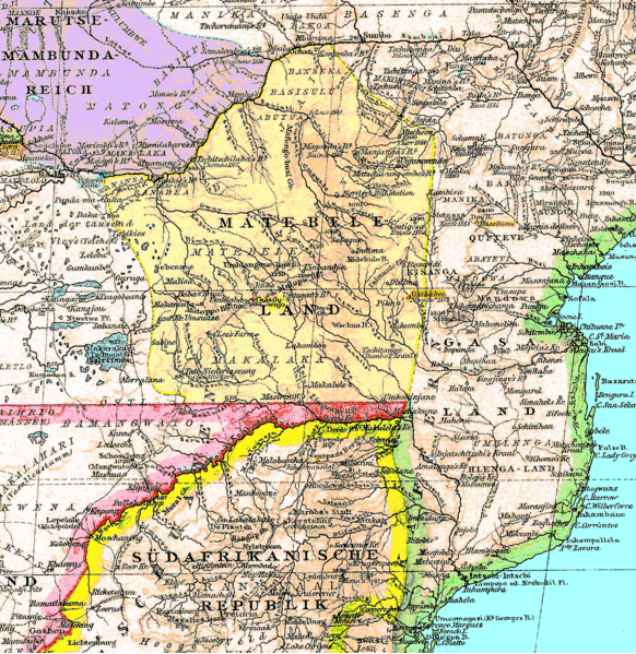
Lobengula Khumalo (c. 1845 – presumed January 1894) was the second and last official king of the Northern Ndebele people (historically called Matabele in English). Both names in the Ndebele language mean "the men of the long shields", a reference to the Ndebele warriors' use of the Nguni shield. Background The Matabele were descendants of a faction of the Zulu people who fled north during the reign of Shaka following the ''mfecane'' ("the crushing") or ''difaqane'' ("the scattering"). Shaka's general, Mzilikazi led his followers away from Zulu territory after a falling-out. In the late 1830s, they settled in what is now called Matabeleland in western Zimbabwe, but they claimed sovereignty over a much wider area. Members of the tribe had a privileged position against outsiders whose lives were subject to the will of the king. In return for their privileges, however, the Ndebele people both men and women had to submit to a strict discipline and status within the hierarchy. ... [...More Info...] [...Related Items...] OR: [Wikipedia] [Google] [Baidu] |
Umguza District
Umguza is a district in the southern part of Matabeleland North province in Zimbabwe. It was formerly known as Esiphezini District. Geography Umguza District is bounded by Matopo and Umzingwane districts in the southeast, Bulilima and Tsholotsho in the west, Kusile (formerly part of Lupane District) in the north and Bubi in the north and east. It surrounds the Bulawayo metropolitan area to the south on three sides. Places in Umguza * Ntabazinduna (Hill of the Chiefs) * Nyamandlovu a river valley where garden crops are raised. Administration and politics Umguza District is governed by the Umguza Rural District Council, which has its offices in Bulawayo. The district has one constituency, Umguza constituency, which was created out of the old Bubi-Umguza constituency. The constituency consists of the Nyamandlovu and Sawmills areas divided into fifteen wards. Obert Moses Mpofu was elected in 1990 and 1995 as the member of parliament from Bubi-Umguza Constituency, the predec ... [...More Info...] [...Related Items...] OR: [Wikipedia] [Google] [Baidu] |
District Development Fund
The District Development Fund, or DDF, is a Zimbabwe government agency within the Ministry of Rural Resources and Water Development that is charged with the responsibility of providing and maintaining rural infrastructure within the Communal, Resettlement and Small Scale Commercial Farming areas of Zimbabwe. Its programmes are funded by the government, donors and the private sector. Location District Development Fund has offices in every rural district of Zimbabwe and has provincial offices as well as head office in Harare. DDF Divisions Water Division Responsible for construction and maintenance of rural water and sanitation infrastructure; small dams, irrigation schemes, piped water, deep wells and boreholes. Roads Division Since 1980, the District Development Fund (DDF) has been responsible for establishing all-weather road access throughout the rural areas of Zimbabwe. DDF has implemented the planning, selection; construction and/or re-construction and the establishment of ... [...More Info...] [...Related Items...] OR: [Wikipedia] [Google] [Baidu] |
ZINARA
The Zimbabwe National Roads Administration (ZINARA) is a Zimbabwean parastatal responsible for the management, maintenance and development of Zimbabwe's national road network. Background The Zimbabwe National Road Administration (ZINARA) falls under the Ministry of Transport, Communication and Infrastructural Development and was established in August 2001, in terms of the Roads Act of 2001 with the aim of enhancing road network system throughout the Zimbabwe. ZINARA's vision and mission is to become a world class road manager, providing secure, stable and adequate reservoir of funds, to fund effectively maintenance of the national road network through fixing, collection, disbursement and monitoring of funds usage for preservation, enhancement and sustainable development. Governance ZINARA is run under the Ministry of Transport, Communication and Infrastructural Development ZINARA consists of a part-time Board of Directors which serves for a three-year period, and a full-time C ... [...More Info...] [...Related Items...] OR: [Wikipedia] [Google] [Baidu] |
Lupane State University, LSU compounds)
{{disamb ...
Lupane may refer to: *Lupane District, Zimbabwe ** Lupane State University * Lupane (compound) (a type of triterpene Triterpenes are a class of chemical compounds composed of three terpene units with the molecular formula C30H48; they may also be thought of as consisting of six isoprene units. Animals, plants and fungi all produce triterpenes, including squal ... [...More Info...] [...Related Items...] OR: [Wikipedia] [Google] [Baidu] |
Water Treatment Plant
Water treatment is any process that improves the quality of water to make it appropriate for a specific end-use. The end use may be drinking, industrial water supply, irrigation, river flow maintenance, water recreation or many other uses, including being safely returned to the environment. Water treatment removes contaminants and undesirable components, or reduces their concentration so that the water becomes fit for its desired end-use. This treatment is crucial to human health and allows humans to benefit from both drinking and irrigation use. Water is the most crucial compound for life on Earth, and having drinkable water is a key worldwide concern for the twenty-first century. All living things require clean, uncontaminated water as a basic requirement. Water covers more than 71 percent of the earth’s surface, but only around 1% of it is drinkable according to international standards due to various contaminations . Waste water discharge from industries, agricultural pollu ... [...More Info...] [...Related Items...] OR: [Wikipedia] [Google] [Baidu] |
Movement For Democratic Change – Tsvangirai
The Movement for Democratic Change – Tsvangirai (MDC–T) is a centre-left political party and was the main opposition party in the House of Assembly of Zimbabwe ahead of the 2018 elections. After the split of the original Movement for Democratic Change in 2005, the MDC–T remained the major opposition faction, while a smaller faction, the Movement for Democratic Change – Ncube, or MDC–N, was led by Welshman Ncube. History Foundation The Movement for Democratic Change was founded in 1999 as an opposition party to the Zimbabwe African National Union – Patriotic Front (ZANU-PF) party led by President Robert Mugabe. The MDC was formed from members of the broad coalition of civic society groups and individuals that campaigned for a "No" vote in the 2000 constitutional referendum, in particular the Zimbabwe Congress of Trade Unions. The party split following the 2005 Senate election, with the main faction headed by the founder leader Morgan Tsvangirai and the ot ... [...More Info...] [...Related Items...] OR: [Wikipedia] [Google] [Baidu] |
Midlands Province
Midlands is a province of Zimbabwe. It has an area of and a population of 1,614,941 (2012). It is home to various peoples. Located at a central point in the country, it contains speakers of Shona, Ndebele, Tswana, Sotho and Chewa, as well as of various other languages. Gweru, the third-largest city in Zimbabwe, is the capital of the province. Midlands Province contains Kwekwe, a city of considerable mining and manufacturing industries, in which also the Sable Chemicals Trust maintains a presence. Geography Districts Midlands Provinces is divided into eight districts: * Chirumhanzu * Gokwe North * Gokwe South * Gweru * Kwekwe * Mberengwa * Shurugwi * Zvishavane Local government The Provincial Administrator oversees all eight districts in the province, each district having its own district administrator. District Administrators work with local authorities in their respective districts. Local authorities have their own Chairmen (mayors for municipalities). The ... [...More Info...] [...Related Items...] OR: [Wikipedia] [Google] [Baidu] |
Matabeleland
Matabeleland is a region located in southwestern Zimbabwe that is divided into three provinces: Matabeleland North, Bulawayo, and Matabeleland South. These provinces are in the west and south-west of Zimbabwe, between the Limpopo and Zambezi rivers and are further separated from Midlands by the Shangani River in central Zimbabwe. The region is named after its inhabitants, the Ndebele people who were called "Amatabele"(people with long spears - Mzilikazi 's group of people who were escaping the Mfecani wars). Other ethnic groups who inhabit parts of Matabeleland include the Tonga, Bakalanga, Venda, Nambya, Khoisan, Xhosa, Sotho, Tswana, and Tsonga. The population of Matabeleland is just over 20% of the Zimbabwe's total. The capital and largest city is Bulawayo, other notable towns are Plumtree, Victoria Falls, Beitbridge, Lupane, Esigodini, Hwange and Gwanda. The land is fertile but semi arid. This area has coal and gold deposits. Industries include gold ... [...More Info...] [...Related Items...] OR: [Wikipedia] [Google] [Baidu] |


